Items tagged with 'Upstate New York'
The slow population arc of upstate
One in three towns in New England have barely grown since the Civil War: post and visualization. pic.twitter.com/fJhi8ejrNQ
— Benjamin Schmidt (@benmschmidt) July 25, 2017
Check out the map embedded above depicting the era in which municipalities around the Northeast reached 3/4 of their current size. The green marks the era before 1855 -- and, as you can see, there's a lot of green around Upstate New York.
The map is the creation of Benjamin Schmidt, an assistant professor of history at Northeastern. He discusses the map over at his blog, touching on how it highlights the 19th century shift away from agriculture, the later de-industrialization, as well as the rise of suburbs -- and zooming out, one of the ways the Northeast is different from the rest of the country.
Anyway, this map reminded us a little bit of something one of the national consultants who worked on neighborhood-specific assessments for Rezone Albany said to us, that this part of the country is like the Europe of the United States -- there's a lot of history and slow growth. The challenge is finding a way to embrace that and work with it.
[via @sandypsj]
Another look at New York State's population change, this time along the urban/rural split
There's a clickable map inside, because of course there is.
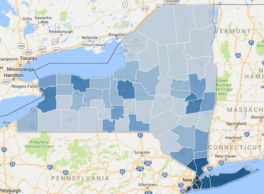
Here's a bonus track from last week's post about the slow population growth of the Albany metro area -- and the melting populations of many upstate counties.
That map above depicts counties by population density. The deeper the blue, the more people per square mile of land. It's pretty much you'd expect. But we had the numbers leftover so we figured we'd roll the map together.
As we mentioned last week, there's been an urban/rural split in the state over the last handful of years for population growth -- basically, counties with higher population densities have added people, while counties with lower population densities have lost. (With a few notable exceptions)
So we grouped the state's population by county density and it makes this divide very clear -- let's have a look, along with a clickable map...
Where Upstate cities are mentioned
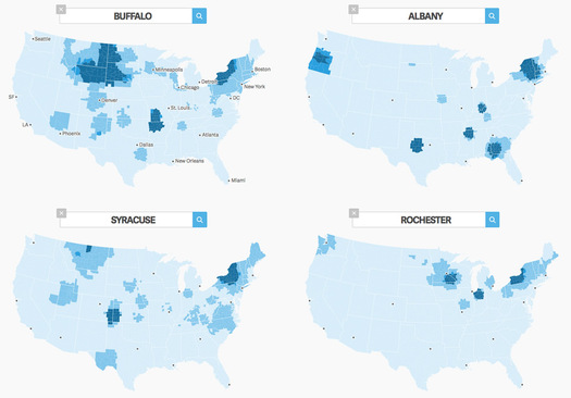
Filed under the Mental Geographies of Upstate: We were playing around with this Twitter word mapper over at Quartz during the break -- it maps the frequency of use of words on Twitter in US counties -- and dropped in the names of Upstate's major cities to get (another) smudgy sense of the regional divisions.
The aggregate map is above -- but here's a larger version.
As with other regional comparisons of Upstate, the results highlight that there appears to a dividing line of sorts that runs through Central New York -- Upstate leans toward Buffalo on the west, and toward Albany on the east. (Call it the Wegmans-Price Chopper line.)
Aside from showing the various spheres of upstate city Twitter influence (or whatever you would call it), another fun thing about the map is way it highlights other cities around the country with the same names. (And in the case of "Buffalo", maybe also the presence of actual buffalo/bison out west.)
Earlier on AOA: What if Albany is upstate, but not "Upstate"?
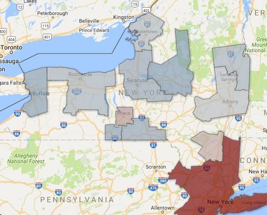
What if Albany is upstate, but not "Upstate"?
What are we really talking about when we use the term "Capital Region"? Is it a geographic place? A population of people? A set of economic connections? A culture?
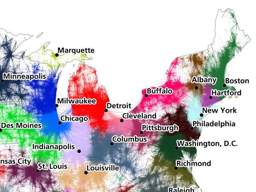
That's one of the questions we were thinking about while looking over a recent attempt by researchers to define megaregions and lay out a "functional economic geography of the United States." The work -- by Garrett Dash Nelson of Dartmouth and Alasdair Rae of the University of Sheffield (UK) -- takes a ton of Census data about commuting patterns and processes it into a series of maps. It's published in PLOS One.
So, let's have a look at those maps for this area, along with a few thoughts about the results.
Clickable county by county results for 2016 presidential election in New York State
There's a clickable map after the jump.
Updated
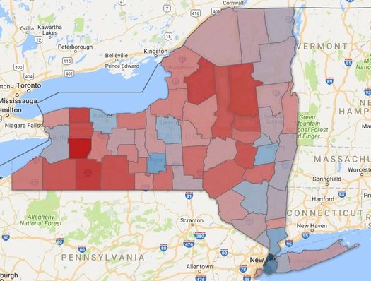
In a presidential election marked by polling surprises, the voting in New York State pretty much shook out as expected.
Here are county-by-county clickable maps of the results, along with a few notes about some geographic voting patterns around the state...
A snapshot of New York State's immigrants
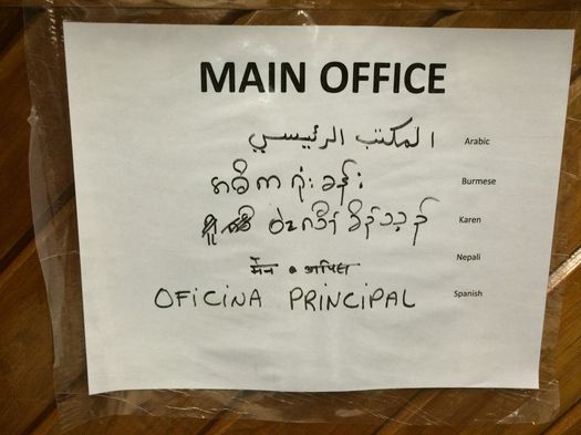
We snapped this pic in the front lobby of Albany High School during a tour last fall.
About 22 percent of the residents of New York State -- almost 4.4 million people -- are immigrants. The second-highest total of immigrants for a state in the United States, behind only California.
That's one of the bits from a report out this week from the state comptroller's office about immigrants in New York State.
There are a bunch of interesting bits in there, and here are a few of them...
The Capital Region leads Upstate in job growth
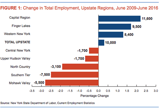
The Capital Region led Upstate New York* in employment grown between 2009 June and 2016 June -- that's from a new report by the state comptroller's office. The Capital Region* was up 2.2 percent over that period, while all of Upstate employment was up just 0.3 percent. It was one of just three (of eight) regions Upstate to see employment growth.
So... good for the Capital Region, right? Yep, but it's not all great.
Here are a few more interesting bits from the report about jobs Upstate...
One thing that sticks out about prices here
You might have seen that map floating around online recently about "the real value of $100 in each state" -- and New York State had one of the lowest "real" values of any state.
That map was based on figures published by the federal Bureau of Economic Analysis. And one of those figures is something called the regional price parities (RPPs) -- an attempt to measure how much goods and services cost in an area compared to the rest of the country.
You can probably now guess why the state level number for New York is kind of misleading -- if you're lumping in numbers for New York City with numbers for, say, Utica, it's going to be skewed. And to the credit of the think tank that made that state map -- the Tax Foundation -- it followed up this week with a similar map based on metro areas.
Anyway, this is just a long setup for looking at RPPs for metro areas around New York State. There's a static map above for the RPPs for all items across the state's metro areas -- and a clickable map after the jump. And as you can see, most parts of upstate have prices that are about average for the nation -- or lower.
Which is probably what you might expect -- except for one category...
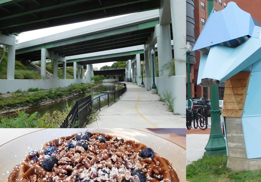
Defining an upstate cuisine
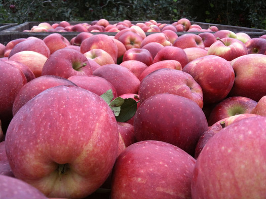
Apples, sure. But the bounty of great local products extends far beyond that.
With the harvest from this past summer finishing up, and Thanksgiving just ahead, we figured it would be a good time for some thinking and discussion about local food. So, it's Following Food Week here on AOA.
Is there an Upstate New York Cuisine?
Sure, in the Capital Region we have mini hot dogs, foot-long fish fry, and mozzarella with melba -- but that's not quite a cuisine, per se. And we have a strong tavern culture, but regardless of how soul satisfying a cheesy, doughy, saucy, tavern pie may be in the midst of winter, it doesn't provide the flavor of the region.
Many regional cuisines are based on the unique combination of local ingredients that are available in the area. And here, at the intersection of the Hudson and Mohawk rivers, surrounded by farms, woods, and mountains, we have plenty of raw materials from which to draw inspiration.
So, with that as a starting place, we asked some talented chefs: "What would an Upstate New York Regional Dinner menu look like?"

Day trip: Syracuse
When you think Syracuse your thoughts probably shift towards collegiate sports, or the image of a snowbound post-industrial city.
But Syracuse is reinventing itself and has a lot to offer. The drive from Albany is a little more than two hours on I-90, so why don't you see what's going on there for yourself?
Here are a few ideas to get you started...
Important predictions about the zombie apocalypse
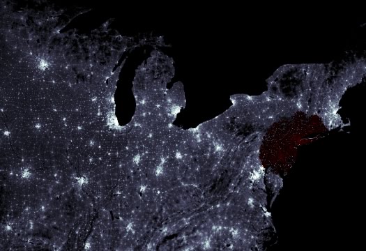
New York City, so many brains, so little time.
Update: Here's a link to an interactive map that research group posted that models how a zombie outbreak would theoretically spread. The map clip above shows the spread from an outbreak in New York City after 96 hours -- AKA, a good time to have already left the Capital Region.
____
So, there's that: When the zombie apocalypse arrives New York City will probably fall in about a day, while upstate New York will have weeks to prepare for the undead assault. So conclude a group of Cornell researchers who have done statistical modeling of a zombie outbreak.
The group was set to present its research at an American Physical Society meeting this month. Press release blurbage:
In most films or books, "if there is a zombie outbreak, it is usually assumed to affect all areas at the same time, and some months after the outbreak you're left with small pockets of survivors," explains [Cornell grad student Alex] Alemi. "But in our attempt to model zombies somewhat realistically, it doesn't seem like this is how it would actually go down."
Cities would fall quickly, but it would take weeks for zombies to penetrate into less densely populated areas, and months to reach the northern mountain-time zone.
"Given the dynamics of the disease, once the zombies invade more sparsely populated areas, the whole outbreak slows down--there are fewer humans to bite, so you start creating zombies at a slower rate," he elaborates. "I'd love to see a fictional account where most of New York City falls in a day, but upstate New York has a month or so to prepare."
Maybe the Regional Economic Development Councils can work zombie-prevention projects into the next round funding pitches.
Also, new slogan: "Upstate New York, Fewer Humans to Bite!" See, any negative can be in turned into a positive.
(In all seriousness, the zombie stuff is just another way to talk about modeling disease outbreaks.)
[via Upstater]
Earlier on AOA: How to survive the zombie apocalypse in the Capital Region
The future is mobile
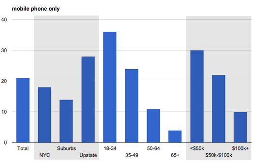
Don't squint -- there's a larger version after the jump.
A Siena poll out this week had some interesting bits about mobile phone and other communications tech usage.
Among those bits: 28 percent of upstate respondents to the poll reported having only a mobile phone -- no landline. That was the highest mobile-only percentage for any region in the poll.
Here are a few things that caught our eye, in quick chart form...
Coxsackie. Skaneateles. Canajoharie.
This is total linkbait, but it's funny linkbait: The real estate website Movoto asked Californians how to pronounces the names of places in upstate New York.
Coxsackie. Skaneateles. Canajoharie. And so on. Hijinks ensue.
What if Upstate New York and Downstate New York were separate states?
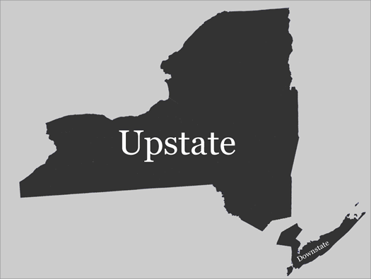
Not that this would ever happen.
The other day Rob Astorino, the Westchester County exec who's running for governor as a Republican, tweeted a jab at the Cuomo administration over the number of jobs upstate. We'll leave it to someone else to assess the merits of this jab, but a construction Astorino (or whoever tweets for him) used caught our eye: "If upstate New York were a state itself..."
And that got us thinking a little bit: What if Upstate and Downstate New Yorks broke up? What would they look like in a few basic ways?
So we pulled together some numbers...
A future of more extremes
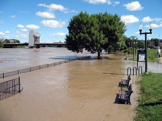
Very heavy precipitation events -- like Hurricane Irene in 2011, which flooded many areas of the region -- are becoming more common in the Northeast, according to the National Climate Assessment.
Unusually large rainfall events that result in flooding. Early spring that results in fruit tree blossoms getting zapped by frost. Exceptionally hot days in places where people haven't typically used much air conditioning.
Those are a few examples of events that are projected to become more common in the Northeast due to climate change, according to a report out today called the National Climate Assessment. It's the product of a federally-organized effort to "understand, assess, predict, and respond to human-induced and natural processes of global change."
The report looks at the whole country, but it also breaks down what's happened already -- and what's predicted to happen -- regionally. So, let's take a look at some of the bits for the Northeast...
A redrawing of the Jeter-Papi line
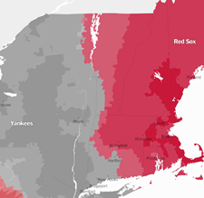 A follow up on the very important matter of the Jeter-Papi Line that divides New York from the rest of the Northeast: The New York's Times' new Upshot site/blog/explainer product got a hold of the Facebook data used for that previous major league baseball fan map and created an interactive fan map with more detail.
Two quick things:
+ The Jeter-Papi line actually runs through Western Massachusetts, southern Vermont, and then -- gasp -- into New York State along Lake Champlain.
+ Outside a few counties in the Hudson Valley, the Red Sox registered as having more fans than the Mets in just about every other upstate New York county.
(Thanks, Tim)
map clip: NYT/The Upshot
Disasters, relatively speaking
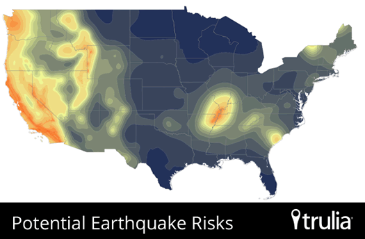
Upstate New York is among the "lower-risk" areas of the country for natural disasters, according to calculations/maps created by Trulia. The real estate website has been rolling out natural hazard maps -- for earthquakes, hurricanes, tornadoes, wildfires, flooding -- for locations across the country. (Example: Here's the flooding risk map for Schoharie.)
Specifically, Syracuse and Buffalo were ranked among the top-10 lower-risk metros:
1. Syracuse, NY*
2. Cleveland, OH
3. Akron, OH
4. Buffalo, NY
5. Bethesda-Rockville-Frederick, MD
6. Dayton, OH
7. Allentown, PA-NJ
8. Chicago, IL
9. Denver, CO
10. Warren-Troy-Farmington Hills, MI
* Trulia note: The data on flood risk, which comes from the Federal Emergency Management Agency (FEMA), is incomplete for Syracuse and for several other metros not on the ten lower-risk list.
As Trulia points out, lower risk is not the same as no risk. And there are natural challenges beyond floods and earthquakes:
Notice that we're not calling these "safe" or "low-risk" metros. It's all relative, and every metro has some risk. Even the 10 lower-risk metros, above, all have some natural disasters in their distant or recent past. This ranking, and our hazard maps, are based on the best data available: recent government assessments of flood, earthquake, and wildfire risk, and years of historical data on hurricanes and tornadoes (all from the federal government, plus some earthquake data from the California Geological Survey). But disasters can be unpredictable. Even Buffalonians need to be prepared for the worst. ...
The 10 lower-risk metros for natural disasters have other crosses to bear. What upstate New York and northern Ohio lack in tornadoes and wildfires, they make up for in snow. While winter weather may be more predictable than earthquakes or hurricanes, harsh winters bring their own risks: blizzards, frostbite, and falling on the ice. Syracuse, Buffalo, Cleveland, Akron, and Denver are all among the snowiest large metros in the country.
As that clip above notes, the maps are based on data from the federal government. Of course, the map is only as good -- and as fine-grained -- as the data set from which it draws. And for some risks, like flooding, there are probably better, more-detailed maps.
The map at the top is Trulia's national picture of earthquake risk. Two more national maps -- for hurricanes and tornadoes -- are after the jump.
[via Atlantic Cities via Innovation Trail]
A whey difficult problem
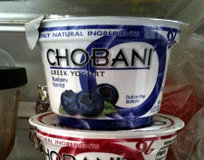 There's an interesting article over at Modern Farmer about "the dark side" of Greek yogurt production: whey -- what's left over from the process of making yogurt. A clip from the article by Justin Elliot:
For every three or four ounces of milk, Chobani and other companies can produce only one ounce of creamy Greek yogurt. The rest becomes acid whey. It's a thin, runny waste product that can't simply be dumped. Not only would that be illegal, but whey decomposition is toxic to the natural environment, robbing oxygen from streams and rivers. That could turn a waterway into what one expert calls a "dead sea," destroying aquatic life over potentially large areas. Spills of cheese whey, a cousin of Greek yogurt whey, have killed tens of thousands of fish around the country in recent years.
The scale of the problem--or opportunity, depending on who you ask--is daunting. The $2 billion Greek yogurt market has become one of the biggest success stories in food over the past few years and total yogurt production in New York nearly tripled between 2007 and 2013. New plants continue to open all over the country. The Northeast alone, led by New York, produced more than 150 million gallons of acid whey last year, according to one estimate.
And as the nation's hunger grows for strained yogurt, which produces more byproduct than traditional varieties, the issue of its acid runoff becomes more pressing. Greek yogurt companies, food scientists, and state government officials are scrambling not just to figure out uses for whey, but how to make a profit off of it.
As you know, New York State was the nation's biggest producer of yogurt in 2012, thanks in large part to the Greek yogurt factories in the state (including Chobani). So this is a pressing issue upstate -- especially as companies to continue to expand production. And there doesn't appear to be an easy answer.
Update: Chobani sent along a statement about the situation surrounding whey. It's in full after the jump.
Modern Farmer: Yep, that's the new publication based in Hudson.
It makes us happy to know that there's a Kazoo Museum in New York
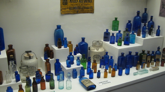
At the National Bottle Museum in Ballston Spa.
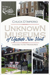 Noted and filed under road trippage: There is book titled Unknown Museums of Upstate New York, by Chuck D'Imperio. Blurbage (links added):
Unknown Museums of Upstate New York is an informative and entertaining guide to the rich resources available at fifty small, often overlooked, regional museums. Even those familiar with the upstate area will likely have never visited and perhaps never heard of some of the treasures this guide unearths, such as the Catskill Fly Fishing Museum, the Kazoo Museum, and the Robert Louis Stevenson Cottage and Museum. D'Imperio tells each museum's story, in light of its cultural and historical relevance, and he provides a wealth of information about the museums as places of interest to visit, not just to read about.
One of the museums in the book is the National Bottle Museum in Ballston Spa -- but, of course, that is not unknown to you.
D'Imperio really seems to have honed in on niche. Among his other books: Monumental New York! A Guide to 30 Iconic Memorials in Upstate New York and Great Graves of Upstate New York
[via North Country Public Radio]
book cover: Syracuse University Press
Yogurt Empire State
Dairy product fact of the day: New York was the nation's top producer of yogurt in 2012, the Cuomo admin reports.
Producers in the Empire State turned out 692 million pounds of yogurt in 2012 -- up almost 25 percent over the year before. That pushed New York ahead of California, whose production fell almost 7 percent. Ferment that, Golden State.
New York's rise to the top is in large part due to the Greek-style yogurt boom. Chobani, the #1 brand of that type, has a large plant outside Oneonta -- that facility alone produces about half of the yogurt in the state* and consumes 10 percent of all the milk produced by New York dairy farms. And Fage -- the #2 Greek-style brand -- has a plant in Johnstown. And there are more plants in western New York. [USA Today] [Fage]
As the state's yogurt production surges, the state's milk production is having a hard time keeping up -- in part because of the costs of expanding dairy herds and regulations on milk pricing. The situation even has a name: "The Chobani Paradox." The milk crunch was one of the reasons Chobani built a new plant in Idaho. [WSJ] [Food Engineering Mag]
The situation has prompted state leaders to look for ways to help dairy farms expand. Example: Chuck Schumer has proposed federal tax breaks ( not without criticism) and immigration reform (to help dairy farms with workforce issues). And today the Cuomo admin announced it was relaxing some environmental rules on the number of cows that can be kept at large feeding operations. [Chuck Schumer office] [NYDN] [Slate] [Chuck Schumer office]
By the way: Chobani founder Hamdi Ulukaya is scheduled to be the speaker at the Sage Colleges' commencement in May.
* Estimate is based on production figures from USA Today and NYT in 2012.
Earlier and elsewhere:
+ Businessweek profile of Hamdi Ulukaya, which declares Upstate New York "the Silicon Valley of Yogurt"
+ Upstate is yogurt country
Siena poll: many New Yorkers, especially upstate, not feeling better off than four years ago
 A few bits from the Siena Research Institute's "Annual New York Survey of the Economy and Personal Finances," out today:
+ "Would you say you and your household are better off financially today than you were at this time four years ago or that you are not better off financially than you were in October 2008?"
better off: 35% | not better off: 47% | the same: 17% -- upstate, the split was 34/51/14.
+ When people were asked whether they thought businesses in their community were better off now than four years ago, 64% of people upstate said "worse off" compared to just 14% who said "better off." (The split was 56/17 statewide.)
+ Middle class people in your area, upstate response: 62% worse off | 8% better off | 24% about the same.
+ When asked if people thought the current economic problems were temporary, or "our country's best economic days are behind us" (temporary/behind us): Democrats 56/44 | Republicans 34/66 | Independents 51/49.
+ Support or oppose repealing the federal healthcare reform legislation?
Support: 40% | Oppose: 43% -- the split for Democrats: 29/56 | Republicans: 61/28 | Independents: 43/42
Here are the full cosstabs. SRI says the survey has a margin of error of +/- 3.9%.
Things wooly and Scottish in Upstate New York
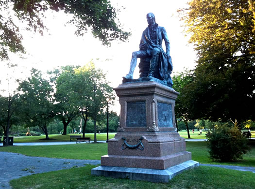
Robert Burns: statue resident of Washington Park, author of New Year's Eve songs no one understands, Scotsman.
You may have noticed there are quite a few Scottish people in the Helderbergs this weekend. They appear to be drinking heavily and throwing telephone poles around.
There's a lot I could say to shed a little light on these odd activities and all things Scottish and local. In fact, I've asked the publishers of this blog to let me do that. So pour yourself a hot toddy (if it's cold) or just a whiskey if it's not, and let's get to it.
1) Those telephone poles are called "cabers."
2) Scotch is a drink, Scots are a people, and Scottish is an adjective.
3) We're not Irish.
An Albany dialect?
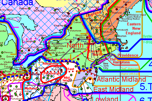
Albany is at the intersection of different dialect areas on this map.
@ajw93 pointed out an interesting site: it's a dialect map of North America. According to this map -- compiled by a linguist named Rick Aschmann -- there's an Albany dialect of American English. A few of the things that characterize this dialect:
+ "Fronted" (tongue near the front of the mouth) vowels in words such as "lot" and "cot."
+ Very little fronting of the vowel in "far."
+ The vowel in "caught" is strongly raised.
+ And these words sound the same: "hoarse" and "horse" | "mourning" and "morning" | "four" and "for."
We've never really noticed a strong "Albany" accent. But if there is one, it's definitely different from other parts of upstate. For example, some people in Central New York have relatively strong accents -- words such as "fire" are pronounced "feuer," and there's the ele-men-TARY pronunciation that occasionally pops up here, too. And, of course, there's the soda/pop divide.
It turns out there's a difference between dialects and accents -- accents are subsets of dialects. And the dialect spoken in Albany and along the Hudson is called, appropriately, Hudson Valley English -- and was influenced by Dutch. Some of the influences from Dutch are still obvious: words such as "kill" (for a creek) and "hook" (for a land point, example: Newton Hook in Columbia County). [Wikipedia] [Wikipedia] [HL Mencken's The American Language]
By the way: The example of the Albany dialect on the Aschmann site is a video clip of Jerry Jennings. Babe.
map: North American English Dialects, Based on Pronunciation Patterns
Upstate Americans
 Casey emails:
A group of concerned upstaters (many of them Capitol denizens) have designed a T-shirt to promote upstate solidarity in the wake of the flooding. Check it out.
Any profits will go to charities providing disaster assistance in the affected regions.
We've all been posting "I am an Upstate American" on our Facebook pages today; on Wednesdsay, we'll change our status to the link above.
The t-shirts are $25 and up. We like the ones with the up arrow design (image right).
Update: Mr. Dave on his pride in being an Upstate American.
Upstate is yogurt country
 The market for Greek-style yogurt has been booming in the US over the last few years.
The manufacturing epicenter for the boom: upstate New York.
Three of the prominent Greek-style yogurt brands are made in this general area. Chobani, now the nation's #1 yogurt brand, is made in New Berlin (it says it's the largest producer of yogurt in the state). Fage opened a new plant in Johnstown a few years ago (as it happens, Chobani also traces its roots to Johnstown). And up-and-comer Siggi's -- which is technically skyr (we believe that's Icelandic for "Greek yogurt") -- is made in Norwich (and there's actually a guy named Siggi). [Businessweek] [Oneonta Daily Star] [Inc.]
The surge in demand for this kind of yogurt has been remarkable. The market has grown 100 percent a year for the last three years. Fage describes the situation as "ridiculously strong consumer demand." And the last time we were in Hannaford, a sign on the Chobani case said they were out of some flavors because the company couldn't keep up. [Business Insider]
But why upstate New York? Watershed Post's Julia Reischel had the best line about that: "Maybe it's the culture."
[via Watershed Post]
image: Fage
Capital Region 2010 census population totals
The Census Bureau released 2010 populations totals for places in New York State Thursday afternoon.
The population of the Capital Region's four core counties was up more than five percent since the last census in 2000, which made this area an outlier for upstate. Breakouts for the individual local counties are above (breakouts for all the cities and towns in the Capital Region are after the jump).
New York State's population was up about two percent, as was New York City's population. Officials there are already arguing there was an undercount.
Breakouts for Capital Region cities and towns -- as well as a few notes -- after the jump.
The last decade: not so good
 Only 19 percent of New Yorkers in a recent Siena poll said their quality of life and that of the people around them had gotten better during the last 10 years. Thirty-nine percent said it was about the same. And 40 percent said it had gotten worse.
The responses from upstaters were even more grim. Just 11 percent reported quality of life was better. And 49 percent said things had gotten worse.
The groups with the highest percentages reporting quality of life improvements: people in the "other" ethnic category (31 percent), and people in the New York City (27 percent).
The groups with the highest percentages reporting thing had gotten worse: ages 50-64 (53 percent), and Republicans (52 percent).
Responses were more or less the same across income levels. Though only 13 percent of people in the $50k-100k range reported that things had gotten better for them (versus 20 percent in the group below, and 22 percent in the group above).
And what about over the next ten years? Responses were about equally split among better, about the same, and worse.
Leveling the snowy playing field
Sure, Albany and the other cities in the Golden Snowball competition are getting owned by Syracuse and its epic 173.5 inches of snow this year. Outlier season or not, the Salt City should dominate -- it averages 121 inches a year (lake effect!).
So let's level the snow field a bit. How would the upstate New York competition for snowiest winter stack up if the cities were competing against their typical totals? The table above shows the results.
OK, so Syracuse still crushes. But look at Albany in the #2 spot. Taste the cold reality of third place, Binghamton. Get in line, Rochester. And Buffalo, dude, you're better than this.
By the way: This season's total of 83.6 now ranks 12th 15th on the list of recorded snowfall seasons.
(Thanks, Rhea!)
Data via New York State Golden Snowball Award. Totals as of end of March 7.
... said KGB about Drawing: What's something that brought you joy this year?