The CDTA iPhone app

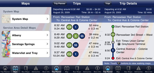
Screenshots from the app.
CDTA released an update to its iPhone app this week, so we decided to check it out. And it's pretty cool.
The app has four primary functions: map, stop finder, trip planner, advisories. The map alone would be worth a download, but the other functions are helpful, too -- especially if you don't ride the same route all the time or you're not a hardcore CDTA rider.
Maps
The app includes a system map, along with detail maps for Albany, Saratoga Springs and Watervliet/Troy. (Oddly, there's no Schenectady detail map.) The maps zoom in and out with the standard iPhone tap/pull/pinch gestures. There's also a "locate my spot" crosshairs (which uses GPS), like in Google maps and other apps.
One thing that would have been nice: to be able to tap a stop and pull up its info.
Stop finder
The stop finder is even better than a clickable map, though. It includes three options: locate nearby stops, search stops, browse by route. The "locate" function is great -- it uses GPS to figure out where you're at and then pulls up nearby stops. A tap on a stop pulls up info on the next scheduled arrivals (and, with another tap, a map). The "search" function returns a huge list of stops (sorted alphabetically) with a search field. The "browse" function is another list, this time sorted by route number.
Trip planner
This is great. You tell it where you're at (or let it guess using GPS), where you want to go, when you want to go and it returns a list of routes you could take. The trip details include stop info, travel time and cost. There are also links to pedestrian maps.
Advisories
Basically a stream of notes about service advisories.
One thing that could have been helpful
As one of the app's reviewers noted, a "favorites" list of routes or destinations, which would navigating the app faster and could be used to notify riders of changes/advisories/upcoming arrivals.
And... it'd be good to have apps for other phones, too. Not everyone has an iPhone (or, for that matter, a smartphone).
Bonus: CDTA is testing a stripped-down text message service for upcoming arrivals.
Say Something!
We'd really like you to take part in the conversation here at All Over Albany. But we do have a few rules here. Don't worry, they're easy. The first: be kind. The second: treat everyone else with the same respect you'd like to see in return. Cool? Great, post away. Comments are moderated so it might take a little while for your comment to show up. Thanks for being patient.
Comments
This is cool, but unless its lightning quick, you can get great bus directions via the built in google maps "directions" feature...just select the public transportation button on the top of hte screen
... said Ike on May 27, 2010 at 6:39 PM | link
how about a function that tracks the imminent arrival of your bus?
As in, the #10 will arrive at your stop in ... 10 minutes.
a la trimet.org transit tracker.
... said Kathy on May 28, 2010 at 9:06 AM | link
One of the things I really noticed when I moved back here from Syracuse was how bad CDTA's printed maps and schedules were, in comparison to Syracuse's Centro. For my own home route, I found it difficult to even figure out what direction around a loop the bus was going in from the maps. They haven't improved a bit on paper, so hopefully this app is an improvement.
However, if I've got an iPhone, am I taking the bus very often? They have a similar trip planner on their website, which works okay once you figure out that the Defreestville park & ride is called "D'ville". Searching for Defreestville won't get you there.
... said CJ on May 28, 2010 at 10:54 AM | link
I have an iphone and take the bus to work every day...not all of us have to live out in the burbs because we're scared of people with brown skin
... said ike on May 28, 2010 at 11:28 AM | link
A quick comment to Ike,
Google maps does a good job as a general tool, but the CDTA app offers a few advantages in the Capital District because it is so tailored to the region. Here are some specifics...
1. It will work quickly regardless of internet availability or speed because the schedules are pre-loaded and trips can be planned without internet. (Especially great for iPod Touch users)
2. It has a list of stops and routes you can choose from... So if you know you want to take public transit, you don't have to do any coaxing by typing in an address or doing a "pin drop" in google maps.
3. It offers quick and direct access to maps showing just the routes. (The google maps are often too busy and make it hard to find bus routes)
4. It offers direct access to advisories. Otherwise you'd have to go online and find the page or lookup a bookmark in safari.
Again, the basic theme of the reasons why CDTA iRide might suit your needs better then Google maps is that it was specifically designed for the region and not designed as a general tool for all regions.
... said David Hodge on May 28, 2010 at 2:00 PM | link