Politics and cartography
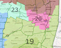
 The state task force in charge of drawing legislative districts based on new census data has yet to release its final maps. But this week Common Cause New York proposed a set of "non-politicized" legislative districts using "a blank state without reference to existing district lines or incumbents." And using a web app from Newsday, you can see how CC's map compares to the current districts -- and even try drawing your own. (CC's maps would include the core Capital Region in three different Congressional districts, as opposed to current two.) Here's a good overview of where the redistricting process is at -- and the "chaos" it could become (this is New York, of course). [Gotham Gazette]
Say Something!
We'd really like you to take part in the conversation here at All Over Albany. But we do have a few rules here. Don't worry, they're easy. The first: be kind. The second: treat everyone else with the same respect you'd like to see in return. Cool? Great, post away. Comments are moderated so it might take a little while for your comment to show up. Thanks for being patient.
... said KGB about Drawing: What's something that brought you joy this year?