Tracing the old canal

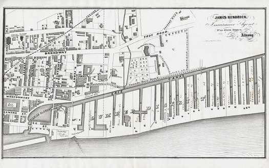
The canal, running along where Erie Boulevard is now, helped create a lumber district in North Albany.
A series of Albany Archives tweets this afternoon about the Erie Canal -- and how you can see the effects of its path still today in Albany -- got us thinking: There's gotta be a map of the old canal route over a modern map. Right? You know, because... the internet.
And guess what: It's true! A website -- the aptly-titled Erie Canal Mapping Project -- has an interactive Google map of the old canal routes layered on top of the modern map. It's interesting to follow along the old canal path to see how often modern roads conform to the waterway's former route.
The map also makes it apparent why so many upstate cities -- Albany, Schenectady, Rome, Syracuse, and maybe others -- have an Erie Boulevard. Those roads are where the canal once was.
Perils of modern maps: Speaking of maps and whatnot -- Carl pointed out a rather bothersome plastic bag captured by the Google Streetview mobile while it recorded along Broadway in North Albany.
Hi there. Comments have been closed for this item. Still have something to say? Contact us.
Comments
Well that was really cool!
Fascinating to see how it went right through neighborhoods and how the path is really still visible today in many places. Makes me want to go check some of the old locks I saw in Cohoes.
... said AlbanyLandlord on Sep 25, 2013 at 9:20 PM | link
One of the the most important engineering feats mankind has ever pulled off - the Canal opened the nation to expansion, carried ideas like suffrage, abolition, and temperance. It put NYC on the map, it made Troy. And yet.... how it this remarkable achievement celebrated in Albany? A historic marker. A 3x5' sign for Canalway Trail users saying "Buffalo, 360 mi. -- >"
We can and should do better. Some ideas that were sent along to the City of Albany that I'm happy to share:
"Albany is the Eastern terminus of the world-famous Erie Canal that made New York City a major center of commerce and finance and opened the western U.S. for expansion. Extending 365 miles across New York, the Erie Canalway Trail brings important economic, public health, tourism, and quality of life benefits to more than 3.7 million New Yorkers living within the 14 counties where the trail is located – yet this trail’s terminus in Albany suffers from little fanfare.
• In the short term additional signage, a gateway arch (See the enclosed document Gateways and Arches), and a monument entrance sign could be installed to commemorate the site.
• In the long term a larger Canalway Trail Gateway could be developed on land reclaimed by removal of 787’s Colonie St. Exit and redesign / relocation of the Clinton Avenue exit and flyover. A significant, world-class gateway should be constructed to commemorate the Canal and Canalway Trail. A plaza could be developed with interpretive signs, reproductions of Canalway infrastructure (eg. locks, boats, buildings), and temporary exhibits. The plaza itself would be a draw for visitors and tourists. The 232km Le Petit Train Du Nord trail, the longest multiple-use trail in Canada, features a large pedestrian plaza at its southern gateway near the city of Montreal. The plaza is home to shops, restaurants, and celebratory features that create a place that attracts tourists and welcomes trail riders into the area."
Food for thought...
... said daleyplanit on Sep 26, 2013 at 1:09 PM | link
Interesting! Thanks for the link.
... said Kathleen Lisson on Sep 27, 2013 at 10:28 AM | link