Checking out the Troy crime map

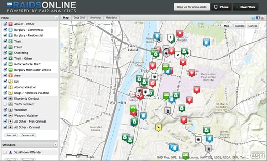
A screengrab from this afternoon.
The Troy Police Department unveiled a new online crime map for the public today. From the press release:
With the exception of crimes related to domestic incidents and sexual assaults, all reported crime in our city will be mapped with a built in 72 hour posting delay. The delay is designed to give Investigators a "first look" at an incident and apply any limitations they see fit specifically relevant to their investigation. Once mapped, the information remains embedded in the mapping, subject to numerous choices the user can make; eg. date range, type of crime, etc. Previously noted exceptions to the mapping will always be subject to inclusion should a public safety need to post the incident be evident.
This is a good step, as we've said a bunch of times before, it'd be great to see other local municipalities head in this direction.
A few more quick thoughts:
Ease of use
In trying out the map for a bit this afternoon, the interface was relatively straightforward and the map functionality will immediately be recognizable to anyone who's used a Google Map-type map. That's a big thing because something like this isn't easy and understandable, people won't use it.
More info
The information provided for each incident is minimal -- just the type of crime, time, date, location type (residential, business), and block-level address. It would be good to see that expanded to include more details about what police say transpired and whether an arrest was made. Further, it'd be interesting if police could tag a string of events as related or possibly related. And even further, it'd great if the map could be the starting point in a storyline of information that links the incident to an arrest to a court outcome.
What shouldn't be shared
As the press release mentioned, the TPD has set up a delay so information shared on the map can be moderated. That touches on some of the important issues related to this sort of public information:
+ How sharing details publicly could help -- or hinder -- the investigation of a crime.
+ To what extent should the privacy of victims protected?
As this sort of public data sharing becomes more common, these issues will keep popping up -- and almost surely there will be missteps along the way. But it's good to see that TPD is thinking about them now.
Different views
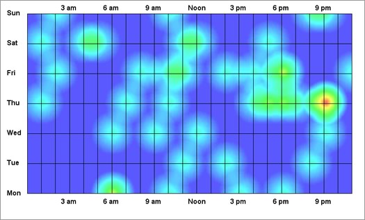
The map also provides views of the incident data by list and in the form of charts and graphs. For example, here's a day/time representation of traffic incident reports for a roughly 10 day period in September:

Those views of the data could be interesting over time.
Upside and downside
Part of the upside to making this sort of information more easily accessible by the public is that 1) people can have a better understanding of what's happening where they live, and 2) maybe it can allow residents to help out by offering tips or suggestions.
But there's also potential downside. Data can often be interpreted a bunch of different ways, and it's easy to string together a bunch of points in a way that's maybe not fair or responsible. As much as there should be a responsibility for governments to share public data, we as citizens also have to make an effort to use it wisely.
In and out
As far as we could tell, there's no public feed or download capability for the crime data. Why keep it locked it up? The data's public and should be available in usable formats for the public, researchers, even other public agencies.
In that vein, it's worth noting that Troy is using a private company to share this data, which is understandable. But what happens if that company stops operating? Will there be a public backup?
The future
As we said up top, this is a good step. And we'd like to see other municipalities go in a similar direction. But you know what we'd really like to see: Local municipalities -- perhaps along with local news orgs -- getting together to agree on common, flexible formats for this sort of data (just say no to PDFs). That way Troy's crime data could easily be pulled together with Watervliet's crime data. Or Troy's codes enforcement data could be cross-referenced with Albany's. (Schenectady mayor Gary McCarthy has been talking about something similar.)
And once all this stuff is published in common, it could be aggregated in a regional online hub to make it easy to find, potentially opening the way for all sorts of projects and products.
____
Earlier on AOA:
+ Car crashes, snow, crime, and public data
+ Keeping up with crime data
Hi there. Comments have been closed for this item. Still have something to say? Contact us.
Comments
I wonder how accurate this is. It would be to their advantage to not post everything. Better for business.
... said Tim on Oct 4, 2013 at 11:31 AM | link