Hudson River rise

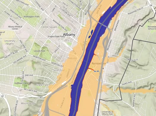
The areas shaded in tan are "100 year floodplains and low-lying areas" after a sea level rise of 6 feet.
After seeing this National Geographic continent-level map based on projections of sea level rise from melting ice, we were curious how rises in sea level could affect the Hudson Valley.
Wait, the Hudson Valley? Yep, it's tidal all the way up to the Federal Dam at Troy. From a Scenic Hudson report (link added):
Over the past century, sea level on the Hudson has risen about a foot--more precisely about 3.2mm per year--a rate greater than the global average. The best data available indicates that we can expect the Hudson's water levels to continue rising up to six feet by the end of this century, and perhaps that much again during the next century.
To help people get a better understanding on the implications of the rising water levels, Scenic Hudson has posted an interactive "Sea Level Rise Mapper." It's good -- it allows you to zoom in on a specific area to see what areas will be threatened, along with projected numbers for affected acreage and households, for the Hudson Valley from just north of NYC all the way up to Troy.
The short story for this area, based on the Scenic Hudson map: Even with a six-foot rise in sea level, many parts of this area along the river would still be protected from permanent inundation (though those low-lying areas of East Greenbush and Schodack along the train tracks get swallowed up). But the area in potential danger during a large flooding event would increase, covering significant portions of Green Island, Troy, Watervliet, Rensselaer, and downtown Albany.
[via Buzzfeed]
Politics Recent argument from Bruce Gyory, a political consultant here in Albany and adjunct professor of political science at SUNY Albany: Climate change will become "the fundamental factor realigning American politics." [City & State]
Earlier on AOA: Photos of Irene flooding in Troy
map: Scenic Hudson
Say Something!
We'd really like you to take part in the conversation here at All Over Albany. But we do have a few rules here. Don't worry, they're easy. The first: be kind. The second: treat everyone else with the same respect you'd like to see in return. Cool? Great, post away. Comments are moderated so it might take a little while for your comment to show up. Thanks for being patient.
Comments
According to the Sea Level Rise Mapper, at 72", Albany has one person at risk of permanent inundation and North Greenbush has 2 at risk of increased flooding. Who are these people, and where exactly do they live?
... said Interesting on Nov 4, 2013 at 9:07 PM | link
Curious & too lazy to look it up: how much did the Hudson rise when we had those storms a few years ago that flooded the Albany waterfront? I remember parts of Broadway/Downtown being underwater.
... said ethan on Nov 5, 2013 at 9:45 AM | link
That National Geographic story was awesome. Great visuals!
... said J. Welf on Nov 5, 2013 at 10:07 AM | link
I did some digging into my own question. That was Irene, around August 29, 2011. According to NOAA that was the 12th highest Hudson on record at more than 15ft.
... said ethan on Nov 5, 2013 at 10:39 AM | link
I will consider this my weekly map 'fix.' Thank you AOA.
... said Jason on Nov 5, 2013 at 12:33 PM | link