The trip to New York City, then

This is total historical/map nerd candy: The 1936 Atlas of the Historical Geography of the United States is now online in an interactive version, courtesy of the Digital Scholarship Lab at the University of Richmond.
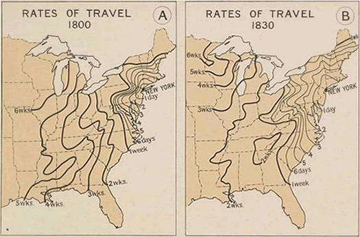
That image above is a clip from an atlas page depicting travel times from New York City in 1800 and 1830. Yep, Albany was a three-day trip from NYC in 1800. (Because there was no E-ZPass, yet. Obviously.)
What makes this online presentation of the atlas so great is the way the pages have overlaid with clickable, zoomable present day maps and paired with additional explanation. Regarding the map clipped above:
In 1800 travel by stagecoach was limited to the area bounded by Boston, Bennington, and Albany on the north, Richmond on the south, and the Allegheny Mountains to the west. It required 10 days of sailing to travel from New York City to Charleston and a minimum of 26 to 28 days to reach New Orleans. Buffalo was a 9-day journey via the Hudson-Mohawk route, and the trip over the mountains to Pittsburgh required 10 days. It required 22-25 days to reach Louisville by way of the Ohio and 28-30 days to reach Cairo. In Tennessee and Kentucky travel on horseback was more rapid than water transportation, because of the circuitous courses of the rivers, and several well-defined overland routes such as the Natchez Trail had already developed.
The period between 1800 and 1830 was one of rapid development of water transportation and extension of highways. It marked both the development of the steamboat as a means of transportation and the completion of the Erie Canal. The traveling time from New York to Charleston was reduced to 6 days and to New Orleans to 14 days. To Cleveland was a 10-day and to Detroit a 13-day journey. From Detroit to Chicago was a 6-day trip overland, the much longer trip by water requiring about two weeks.
The atlas and website are filled with interesting bits, many of which include Albany and New York State in some way. Among them: Public Post Roads and Stage Routes 1774; and the De Laet Map of 1630, depicting Nieuw Neder Land and Fort Orange.
The whole thing is definitely worth a look.
[via Quartz]
image: Atlas of the Historical Geography of the United States/Digital Scholarship Lab, University of Richmond
Hi there. Comments have been closed for this item. Still have something to say? Contact us.
Comments
Are you people not aware I'm trying to get some work done today? Cut it out!
... said Carl on Jan 3, 2014 at 12:35 PM | link
@Carl: lol. I'm about to get sucked into Map Heaven myself.
... said Ellen on Jan 3, 2014 at 5:20 PM | link
an interesting point to think about....about 100 years ago (and then some), the average American didn't go beyond six miles from where they were born.... puts it into perspective, eh?
... said stacey shinske on Jan 5, 2014 at 9:00 PM | link