Icy, Snowy Apocalypse Watch (updated)
Update: Thursday 9 am
We're revising the snowy apocalypse for this storm upward based on the latest forecasts. (previous watch post jump) The paraphrased outlook from the NWS:
Thursday: Light snow through the morning, picking up as the day continues. The later afternoon might see snowfall rates of an inch an hour, increasing into the evening. Daytime totals could range between 3-7 inches. Highs in the mid 20s.
Thursday night: Snowy drama continues, perhaps with periods of 2 inches of snow an hour -- some places might even hit three inches an hour at some point (that's... a lot). Additional accumulation of 3-7 inches. Lows in the mid 20s.
Friday: Maybe a bit more snow in the morning, probably no more than an inch. Mid 30s.
NWS has issued a winter storm warning for the Albany area from Thursday 10 am to Friday 10 am.
As mentioned in the first version of this snow apocalypse watch, this storm is a Nor'easter, which are always a little tricky to figure. And you can see that in the snowfall prediction totals -- 6-14 inches is a rather wide target. Based on the accumulation probability map, it looks like the chances for 8 inches are very good (something like 80 percent), and the chances of a foot or more aren't bad at all (something like 40-50 percent). And as it happens, a NWS Albany snowfall total forecast map posted early this morning has most of Albany and Rensselaer counties pegged for 10-14 inches, with Saratoga and Schenectady counties in for 8-10.
Again, though, Nor'easters are tricky, and if its path shifts one way or the other as it moves up the coast, we could see a swing up or down. The Capital Region is toward the edge of the storm -- a few counties away the forecasted snowfall totals are just 4-6 inches.
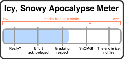
Still, 10 inches from this storm doesn't seem like a bad bet, and a foot -- or even a bit more -- wouldn't be surprising. So we've upgraded to a solid "grudging respect" icy, snowy apocalypse.
Shovels at the ready, upstaters.
Media freakout forecast: Continues to be high. Obviously.
Necessary note: You should take this all with an enormous bag of rock salt. AOA has absolutely no weather forecasting expertise. At all. That said, the world will probably not end because of some snow. Most likely.
____
You know those movies -- thrillers/action flicks/the occasional dramedy -- where you're pretty sure you know how the story's going to play out, but there's a part of you, maybe 25 percent, that thinks the movie could still throw in an unexpected twist at the end?
Well, welcome to our latest icy, snowy apocalypse. The plot: A classic Nor'easter storms up the coast, spreading icy mayhem through the southern states, burying sections of the mid Atlantic, while the Northeast waits with quiet determination, shovels and plows poised to strike. All the while, the hype monkeys spasm with joy until a Weather Channel personality is found half naked, frost in his hair, clutching a microphone, trying to take one last hit off the outdoor live remote pipe.
How does it end? We think we know -- but we don't really know until it all plays out.
The paraphrased forecast:
Wednesday: Sunny, cold. Watch as the characters go about their normal day, they're just like you.
Wednesday night: Calm, cold. Maybe too calm. Then the snow begins.
Thursday: Light snow through the morning, then the snowy fury is unleashed shortly before noon. Maybe four inches. The non-starring characters gather by the office window to take in the developing apocalypse.
Thursday night: Snowy drama continues with another 4 inches. But... maybe this apocalypse is just misunderstood -- maybe it's actually lovable on the inside and just needed someone to listen.
Friday: Maybe a bit more snow. Mid 30s.
You know the deal with a Nor'easter: The track of the storm can make a big difference in how much snow we get here. A little farther west, we get dumped on. A little farther east, and, eh, not so much. The forecasts are tricky and we never seem to really know what's going to happen until it actually happens.
And this storm doesn't seem to be any different. The forecast discussion indicates the models aren't all pointing the exact same direction, so the whole picture is a bit unclear. But the bottom line seems to be that were are in for "moderate to heavy" snowfall in this area. And based on the probabilistic forecast and accumulation map, it looks like the best bet -- a greater than 50 percent chance -- is for at least 8 inches in the Albany area. The thing to keep in mind is that Capital Region is going to be on the outer reaches of the storm, so there will probably more snow to the east and south, and less snow to the west and north. And, of course, the track of the storm -- in this case, Cape Cod is the reference point -- could push those totals either way.
Things could change, but as of right now, we're going to peg this as moderate "effort acknowledged" icy, snowy apocalypse.
Shovels at the ready, hardy Upstaters.
Media freakout forecast: High. This storm will be plowing through some of the most populated areas of the country. And the forecasts for Atlanta and nearby parts of the south include "mind-boggling if not historical" zombie-apocalypse-level predictions of ice and snow.
Necessary note: You should take this all with an enormous bag of rock salt. AOA has absolutely no weather forecasting expertise. At all. That said, the world will probably not end because of some snow. Most likely.
Hi there. Comments have been closed for this item. Still have something to say? Contact us.
Comments
YAY! A REAL WINTER! HUZZAH!
Better make sure all my woolens are clean.
... said ethan on Feb 12, 2014 at 10:59 AM | link
My favorite weather forecast (that isn't the AOA forecast)
http://www.atmos.albany.edu/index.php?d=wx_forecast
Though I'm not liking how this is shaping up...
A major snowstorm is expected tomorrow as a cyclone currently
affecting the southeast U.S. with rare heavy snow and ice will
make its way up the east coast of the U.S. tomorrow. The models
are finally coming to a consensus that will give the Capital
Region substantial snowfall with this storm. Expect the snow to
begin late morning tomorrow, and pick up in intensity by late
afternoon tomorrow. The heaviest snow looks to fall as a snow
band sets up over the region from around sunset tomorrow through
early morning Friday. Locations beneath this heavy snow band
the longest may still be just to our southeast over western
Massachusetts, northwest Connecticut, and about 50 miles south
of Albany...but a subtle change in the models would bring the
heaviest snow axis right through Albany, and there are some
models that do indeed show this. Along with the snow, strong
winds should also be occurring, causing blowing and drifting
and poor visibility...although the snow won't be extremely dry
and powdery as some of our more recent snow events.
The snow should wind down by Friday morning, but widespread
snow totals of 8-14" are expected across the region, with
higher amounts likely in places that remain beneath the heavy
snow band longest.
The weekend looks quieter with light snow possible early
Saturday morning. Temperatures in the next week look seasonable,
with slightly cooler than normal expected...especially with
overnight lows considering our predicted deep snow pack.
... said Andy on Feb 12, 2014 at 12:03 PM | link
I just wanted to take a moment to say that you all are great. I don't refuse to get my snowpocolypse news anywhere else. Keep up the good work and the succinct, entertaining, shrill-free and largely accurate weather reporting.
... said Katherine on Feb 13, 2014 at 8:54 AM | link
Quote of the week:
"Well, welcome to our latest icy, snowy apocalypse. The plot: A classic Nor'easter storms up the coast, spreading icy mayhem through the southern states, burying sections of the mid Atlantic, while the Northeast waits with quiet determination, shovels and plows poised to strike. All the while, the hype monkeys spasm with joy until a Weather Channel personality is found half naked, frost in his hair, clutching a microphone, trying to take one last hit off the outdoor live remote pipe."
Good stuff!
... said Diana on Feb 13, 2014 at 2:37 PM | link
After shoveling for 2 plus hours and still not being done, I'd like to kindly request the meter be adjusted to SnOMG. Thanks!
... said Valerae on Feb 14, 2014 at 8:20 AM | link
@Valerae: Heh. If it had looked like we were in for 20 inches, it definitely would have registered as such! This Nor'easter franchise is full of surprise twists.
... said Greg on Feb 14, 2014 at 9:54 AM | link
No snow grade inflation on AOA.
... said chrisck on Feb 14, 2014 at 11:56 AM | link
This storm lived up to the hype.
... said Rob on Feb 14, 2014 at 2:35 PM | link