Icy, Snowy, Apocalypse Watch (update x2)
Updated overnight Tuesday to Wednesday
Again, significant updating because the forecast for this "complex winter storm" continues to change.
The paraphrased NWS forecast:
Wednesday morning: Precipitation starts. And because temps will be in the upper 30s, it will be rain. And there could be a lot of it -- more than half an inch.
Wednesday afternoon: Temperatures fall during the day. The rain starts to turn to the ever popular freezing rain in the late afternoon/early evening.
Wednesday night: Freezing rain turns to sleet. And then the sleet turns to snow. Accumulation totals between 2 and 4 inches.
Thursday: Snow continues. Very windy. And very cold -- temps in the lower 20s. Generally unpleasant.
Thursday night: Maybe a bit more snow. Lows in the single digits.
Friday: Sunny and 36.
As mentioned before, this storm is going to be like a giant smear across this part of the United States, stretching from the west/southwest to northeast. And within that wintry smear will be very steep gradients for precipitation. How steep? Well, forecasts have the Adirondacks pegged for as much as 20 inches of snow. Lake George/Saratoga for 7-14 inches. And closer to Albany, something like 2-6 inches total.
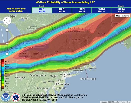
Have a look at the snowfall probability forecast map (screengrabbed post jump) -- it looks like a topographic map of a long (snowy) butte or something: a big plateau of a highly probable snowy deluge stretches from Buffalo through the Adirondacks and into Vermont and Maine, and then steeply declining probability high snowfall totals from about Glens Falls through Albany and into the Hudson Valley.
So small changes in the track of the storm -- or shifts in temperature -- could have a big effect on how things shake out Wednesday and Thursday.
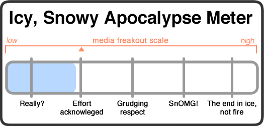
Even though the forecast is now calling for mostly rain during the day Wednesday, we're keeping this pegged as a solid "effort acknowledged" icy, snow apocalypse because of the uncertainty and the threat of possible icing. (We'll take snow over ice any day of the winter.) Depending on when the freezing rain starts, the commute home could be messy.
Lucky shovels at the ready, upstaters.
Media freakout forecast: Low, but trending upward. The hype monkeys live for icy drama, and they're starting to pick up the scent.
Necessary note: You should take this all with an enormous bag of rock salt. AOA has absolutely no weather forecasting expertise. At all. That said, the world will probably not end because of some snow. Most likely.
Here's the NWS snowfall probability forecast map, screengrabbed overnight Tuesday to Wednesday. It's set for snowfall of 8 or more inches. That big, long splotch of deep red is a 95 percent chance of 8 inches or more. And then each band of color from there represents a lower probability. See how the bands are all squished together? That means the probability of that much snow drops quickly as you move away from the splotch.
____
Previous updates
Updated Tuesday morning
Lots of updating because the forecast has shifted a lot.
The paraphrased forecast:
Wednesday morning: Snow begins early, switching to sleet/freezing rain shortly after. And then switching to regular rain later in the morning.
Wednesday afternoon: Rain.
Wednesday night: Precipitation switches back sleet/freezing rain around 8 pm. And then snow after that. There could be a few hours of heavy snowfall resulting in "light to locally moderate accumulation."
Thursday: A bit more snow, tapering off during the day. Cold. Temps in the 20s, dropping into single digits at night.
The track of this storm is going to make a big difference, and there appears to be a lot uncertainty about how it's going to play out. From the NWS forecast discussion:
By the time the storm has completely ended... there will be as much as 20 inches of snow across the Adirondacks. However... a sharp gradient will be in place to the south... with around a foot in the Glens Falls area and western Mohawk Valley... around 6 inches in the Saratoga region...and just 2-4 inches in the Capital Region. Some higher amounts are possible just west of the Capital Region in the Helderbergs... and only a coating to an inch or two for far southern areas. However... these snow amounts are based on the latest guidance... and any slight change in track could allow for more/less snowfall in the transition zone. It's a rather low confidence forecast.
In other words, stay tuned. It's not clear how this is going to turn out.
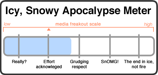
That said, the signs are apparently pointing toward more of a rainy, snowy apocalypse, so we've downgraded this particular apocalypse. It's still higher than what a 4-inch apocalypse would merit because of the uncertainty and the possibility of ice.
Get out your lucky shovel, upstaters.
Media freakout forecast: Low-ish. Everyone's probably got snowy apocalypse fatigue by this point.
Necessary note: You should take this all with an enormous bag of rock salt. AOA has absolutely no weather forecasting expertise. At all. That said, the world will probably not end because of some snow. Most likely.
____
Original Icy, Snowy Apocalypse Watch
@#$%^ snow &^%$# @#$%^&*(*&()) winter @#$%^.
The paraphrased forecast:
Wednesday morning: Snow begins. It will probably be wet and heavy.
Wednesday afternoon: Snow continues, rain/freezing rain/sleet could be mixed in depending how things go.
Wednesday night: More snow, drying out as the temperature drops from upper 30s into the 20s. That should mean fluffier snow -- and higher accumulation totals. Snowfall rates could hit 1 or 2 inches per hour in the evening.
Thursday: A bit more snow, tapering off during the day. Cold. Temps in the 20s, dropping into single digits at night.
The National Weather Service has issued a winter storm watch, projecting a possible 7 inches or more of snow, along with maybe a quarter inch of ice.
Here's the thing about this storm: It's going to be stretched from southwest to the northeast, with vary narrow projected bands of accumulation (see this image). So small shifts in the track of the storm could mean big differences in how much snow we get, and whether there's ice/sleet/rain. Check out the probability forecasts for accumulation -- there are a whole bunch of bands squished together from just south of Albany north to the edge of the Adirondacks.
Here's the 48-hour snowfall accumulation probability map from the National Weather Service, for Wednesday and Thursday. (We'd link to this specific view directly if we could figure out how.) The bands depict the probability of an area getting 8 or more inches of snow.
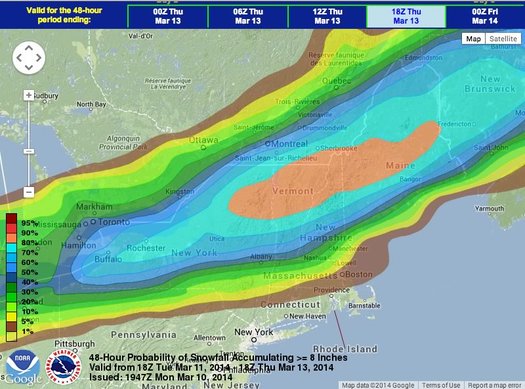
As it stand now, it looks like there's about a 50-50 chance we get hit with 8 or more inches of snow (the probability of higher amounts declines pretty quickly). And, really, we're probably better off with a bit more snow if that means we miss out on ice or freezing rain. Another inch or two of snow is nothing compared to having everything glazed with ice. But because freezing rain is a possibility, we're going to mark this storm a bit higher than we normally would. Thus, the high "effort acknowledged" icy, snow apocalypse.
Get out your lucky shovel, upstaters.
Media freakout forecast: Low-ish. Everyone's probably got snowy apocalypse fatigue by this point.
Necessary note: You should take this all with an enormous bag of rock salt. AOA has absolutely no weather forecasting expertise. At all. That said, the world will probably not end because of some snow. Most likely.
Hi there. Comments have been closed for this item. Still have something to say? Contact us.
Comments
Ha-ha! In your face, winter!
... said Rob on Mar 11, 2014 at 3:58 PM | link