Icy, Snowy Apocalypse Watch

Updated Tuesday 8:30 am.
There continues to be a lot of uncertainty about how this storm will affect the Capital Region, but it looks like forecasts are now leaning toward this being more rain/freezing rain/sleet than snow.
The paraphrased forecast:
Tuesday: Sleet during the late morning, switching over to freezing rain, then rain by the afternoon. Highs in the mid 30s.
Tuesday night: Rain into the night, switching over to sleet and snow late.
Wednesday: Precipitation switches to rain/sleet again, the rain and snow. Mid 30s.
Wednesday night: More rain and sleet. Then some snow.
Thursday: Snow, then -- surprise! -- rain and snow. Then maybe some snow into the evening.
Friday:Maybe some snow in the morning, finished by later in the morning. High around 37.
The most recent NWS 24-hour projection for snow accumulation has the Capital Region core pegged for 1-4 inches of snow, depending on location. The projected totals rise quickly to the west -- the Helderbergs could get six inches and western Schoharie County could get 10-14 inches.
Even so, all that wintry mix could make travel tricky -- there was ice on roads already Tuesday morning. And the next few days look sloppy and wet.
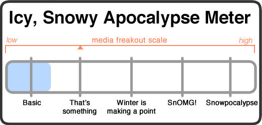
As mentioned Monday, things were bound to change, and they have. We're downgrading this apocalypse to a basic-plus apocalypse. It doesn't look like snow will be a big problem. ** But there's still a possibility of freezing rain and sleet and that could make things messy. And travel will probably be tricky at times because of ice. **
Brake early and lightly, upstaters.
Media freakout forecast: Let down.
Necessary note: You should take this all with an enormous bag of rock salt. AOA has absolutely no weather forecasting expertise. At all. That said, the world will probably not end because of some snow. Most likely.
____

When you're expected to know what's going to happen, it can be uncomfortable to admit that you don't know what's going to happen.
So the Icy, Snowy Apocalypse Watch has respect for the forecasters who are openly admitting they don't have much certainty about the icy, snowy, possibly very wet apocalypse that approaches this Tuesday and Wednesday. Sometimes the most certain thing is that no one is certain.
The paraphrased forecast:
Tuesday morning: A coastal storm will start to drop snow on the Capital Region, maybe a few inches.
Tuesday midday: It looks like this snow will change over to ice/sleet and then rain. There will probably be a lot of precipitation -- on the order of 1 inch for the day. High temps around 37.
Tuesday night: More precipitation. Rain? Snow? Something in between? Who knows! Lows around 34.
Wednesday: More rain and snow, eventually switching over to snow (probably). Highs in the mid 30s.
Wednesday night: Snow continues. Temps around 33.
Thursday: More snow, shifting over to rain into the evening. Temps in the 30s.
The one thing clear about this impending apocalypse is that it could go a few different ways, and the models are pointing different directions. Snowfall accumulation of 7 inches or more, along with ice, is possible. But as the NWS Albany forecast discussion notes, "exact precip type will be a challenge." Also: "The Capital Region is in a tough spot" when it comes to predicting what sort of precipitation it will get. And totals could vary greatly across the region.
The probabilistic snowfall map has the Capital Region core with about a 75 percent chance of 4 inches of snow or more over a 48-hour period. It's less than 50 percent for 8 inches or more. (And definitely click over that map -- it's unusually varied for this type of storm.)
One more key line from the NWS Albany forecast discussion: "This is an extremely difficult forecast... and there is potential for it to change quickly."
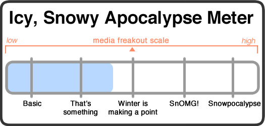
Again, this is a hard one to figure. On one hand, six inches of snow plus rain to melt it isn't necessarily a big deal. On the other, that could be some very heavy, slushy, miserable snow -- with the possibility of blocked storm drains and whatnot. Because of the uncertainty, we're pegging this as a that's-something-plus icy, snowy apocalypse -- though that's probably bound to change.
Shovels at the ready, intrepid upstaters.
Media freakout forecast: Moderate.
Necessary note: You should take this all with an enormous bag of rock salt. AOA has absolutely no weather forecasting expertise. At all. That said, the world will probably not end because of some snow. Most likely.
Hi there. Comments have been closed for this item. Still have something to say? Contact us.
Comments
Yawn.
... said ethan on Dec 8, 2014 at 11:19 AM | link
Soorrry.
... said Sno-bot on Dec 8, 2014 at 5:53 PM | link