The Capital Region lit up by Twitter

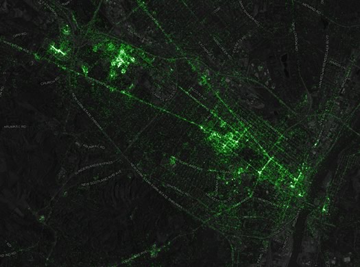
Check out this map of the Capital Region (and the wider world) depicting geotagged tweets for the last 3.5 years. (That's a screengrab above.)
The map is the creation of Eric Fischer, a developer at the mapping company Mapbox. Here's how it was created using some 6.3 billion geotagged tweets.
The patterns here in the Capital Region aren't super surprising -- there are big clusters of tweets pretty much wherever people gather. But a few quick things that caught our eye:
+ Areas with large college students populations registered high concentrations of tweets -- not just campuses, but also neighborhoods like the midtown section of Albany.
+ Transportation nodes and corridors -- such as the Albany-Rensselaer train station, Albany bus station, and interstates -- stand out. (Again, this makes sense -- people are concentrated on transportation corridors. Also, um, maybe there's some tweeting while driving.)
+ Other high density spots: entertainment venues (like the TU Center), hospitals, shopping centers.
(Thanks, Katy!)
Hi there. Comments have been closed for this item. Still have something to say? Contact us.
Comments
Wonderful! Now I know all of the places to avoid.
... said Paul on Dec 9, 2014 at 4:49 PM | link
And the importance of this is?... Twitter will be dead within two years. You can bet your hashtag on it.
... said ace on Dec 10, 2014 at 9:45 AM | link
lol @ twitter being dead within two years... that's idiotic. the fastest quickest way to get and share information is somehow going to disappear? yeah. nope.. not happening ace. stick to your AOL chat rooms to get your breaking news bud.
this map is another reminder of why i am glad i dont share my location on tweets... my places would light up like light bulbs.
... said B on Dec 10, 2014 at 1:05 PM | link