Mapping out bike routes through Albany

Here's the link the full-size map.
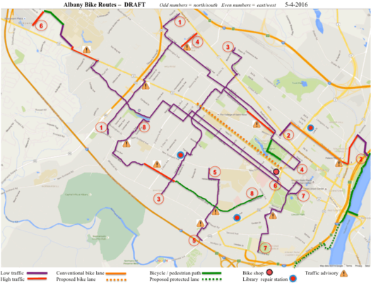
Check it out: The Albany Bicycle Coalition is putting together of map of bike-friendly streets in the city of Albany. And it's looking for help. Blurbage:
Objective: an online map of bicycle-friendly streets in the City of Albany.
Primary considerations: safety and comfort. We hope to encourage novice and first-time riders, by showing that you can cycle throughout Albany yet avoid most busy streets. The map concentrates on secondary roads, side streets, and multi-use paths. Major arteries are used only where necessary to make connections. Traffic density is indicated by color coding.
This is a work in progress, and we value your input!
We encourage you to download and print any of the DRAFT files below, and ride as many routes as you want. Your feedback will ensure that the final map is a valuable tool for the Capital Region cycling community. Please email us:
Comments & suggestions about maps - ghscom1@gmail.com
General questions & comments about this project - lorenzworden@gmail.com
The org is also breaking individual maps out in to their own maps. (The maps are at that link above.) Example: Center Square to the Hannaford on Central Ave.
ABC says it's working with Parks and Trails New York to develop an online interactive version of the map.
Say Something!
We'd really like you to take part in the conversation here at All Over Albany. But we do have a few rules here. Don't worry, they're easy. The first: be kind. The second: treat everyone else with the same respect you'd like to see in return. Cool? Great, post away. Comments are moderated so it might take a little while for your comment to show up. Thanks for being patient.
Comments
Fantastic!
... said Jamie on May 16, 2016 at 1:24 PM | link
I am about to start a job in Troy, Id like to find out the best way to bike from mid-town Albany to downtown Troy.
... said Steve B on May 16, 2016 at 2:28 PM | link
A novice could also include someone generally comfortable with riding a bike, but new to riding or racing a road bike. In those instances, you would like a little more open road where you can comfortably get up to speed and execute a workout without having to be as aware of pedestrians or cars. In that case, I would add the Harriman State Campus (inner loop) to the list. After 5:30pm on weeknights and all weekend long its devoid of cars and full of bikes.
... said Sean on May 16, 2016 at 3:24 PM | link
@Steve B - the "best" way is too subjective. I'd start by heading downtown by either Clinton or State (or one of the mapped secondary/side street routes linked here might be your preference). Then you basically have the option of the bike path or Pearl/Broadway/32 north. NYS Bike Route 9 utilizes the bike path and Broadway from Albany to Watervliet, and crosses the Green Island Bridge into Troy.
... said Ed on May 16, 2016 at 3:49 PM | link
@Sean - my interpretation/assumption is that the project is intended more for transportation routes than recreational routes. There are many resources out there for recreational riding (ride-mapping sites, for example) than for transportation, and I think to serve its (assumed on my part) purpose best, it would be good to avoid watering the Albany Bike Map Project down with purely recreational options. But I think you make a great point; maybe a parallel project can be developed?
... said Ed on May 16, 2016 at 3:55 PM | link
How do they stack up? http://www.cdtcmpo.org/linkage/albanybmp.pdf
... said daleyplanit on May 18, 2016 at 12:47 PM | link