Plotting a path for the Albany waterfront bike trail connector
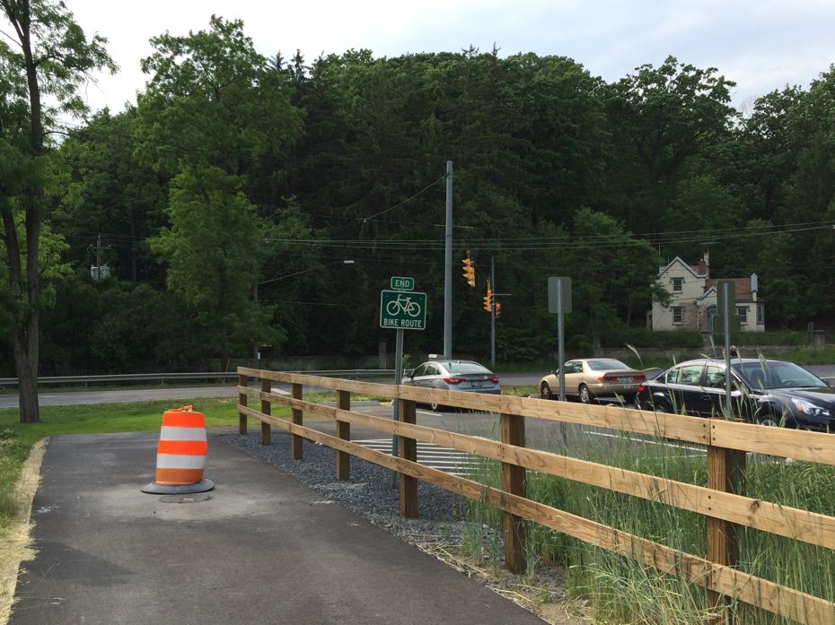
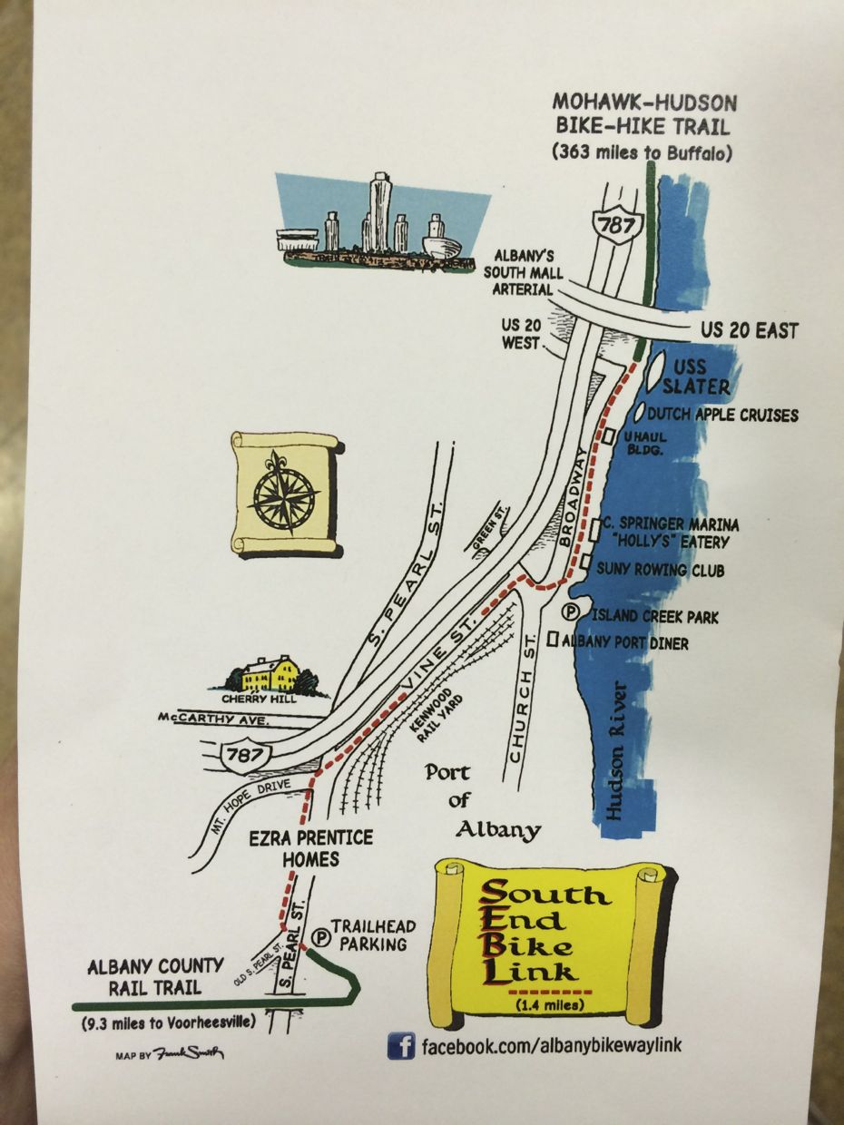
A paved section of the Albany County's Helderberg Hudson Rail Trail recently (officially) opened from Slingerlands to Albany's South End neighborhood. That end point on South Pearl is just about two miles from where the Mohawk-Hudson Hike-Bike Trail picks up along the Albany riverfront.
And that proximity, of course, prompts the idea: Hey, maybe these should be connected in some meaningful way, right?
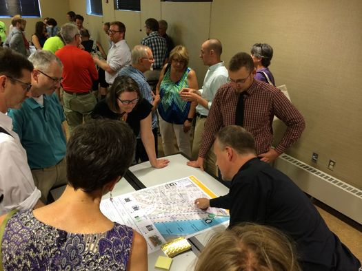
The question of how that make connection happen is at the center of the Albany Waterfront Connector project. And Thursday night there was a public meeting laying out some of the possible options.
Here's a quick look.
What is it?
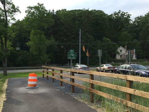
There aren't a lot of specifics, yet, but broadly speaking the idea here is to lay out some sort of explicit path that connects the Helderberg-Hudson Rail Trail and Mohawk-Hudson Hike-Bike Trail in Albany's South End.
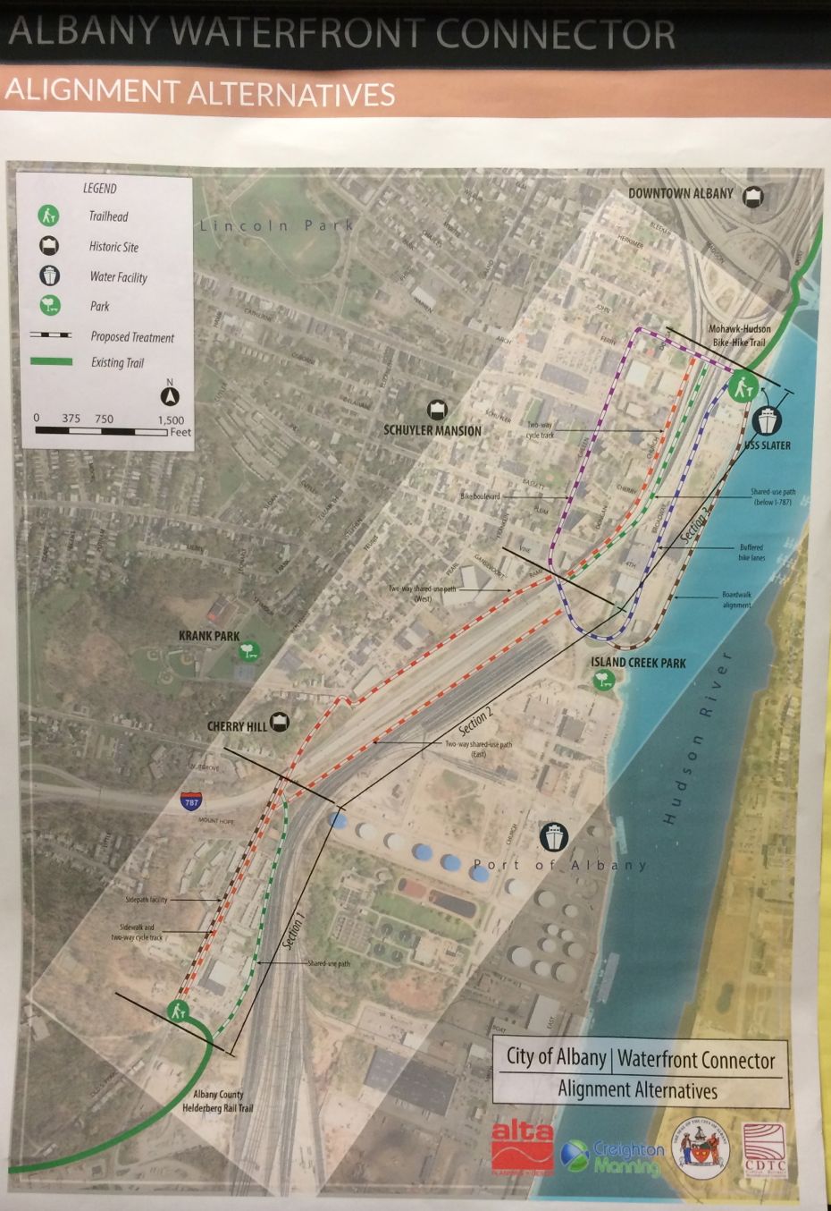
The project could ultimately end up involving the construction of some sort of new bike/walk trail or new amenities for biking on already-existing streets (like bike lanes) or some combination. Planners have broken down the distance between the two trails into three sections, and it's possible that each section could get its own treatment.
The city of Albany is working with Alta Planning + Design on the waterfront connector, a firm that specializes in these sorts projects.
The options (so far)
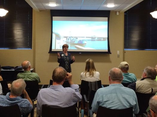
It's important to note that nothing was presented as a done deal. As mayor Kathy Sheehan said at the start of the meeting at the Howe Branch library: "I really want us to explore all of the possibilities." And she emphasized that at this point the potential ideas shouldn't be ruled out because of cost or complications involving land acquisition.
So, here were the initial options that were floated. There are versions of these photo above in large format.
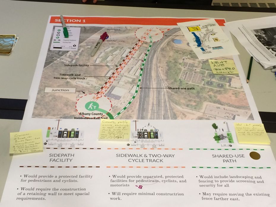
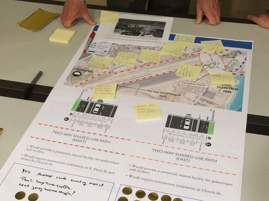
Section 1: rail trail terminus to Mt. Hope

+ Side path along Pearl Street: This would be a multi-use path built alongside the street. (None of the consultants used this example, but based on the description, we kind of got the idea it would be like the multi-use path along Hackett Boulevard.)
+ Sidewalk and two-way cycle track along South Pearl: In this case cycle track essentially means a two-way bike lane built on the street with some buffer between the bike lane and vehicle traffic.
+ Shared-use path behind Ezra Prentice Homes: This would involve building a multi-use path in a thin strip of space between the train tracks and the Albany Housing Authority's Ezra Prentice Homes. No one ruled this idea out -- again, the consultants emphasized that everything was on the table -- but we got the feeling this option seemed like a long shot because there were three points along the route where this isn't a space between EPH and the train tracks, and there'd have to be some arrangement made with the railroad to get the space.
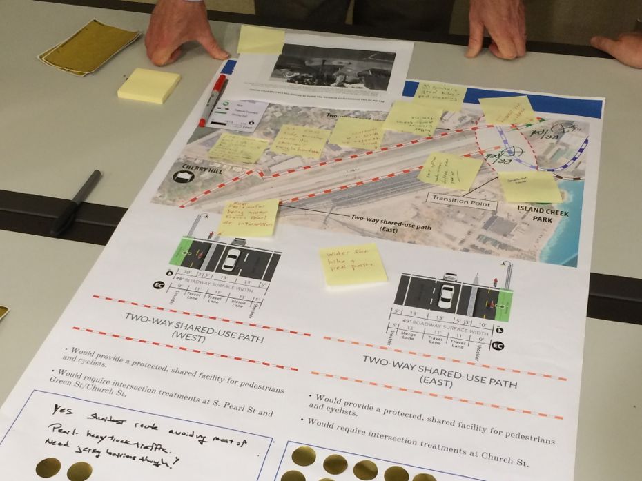
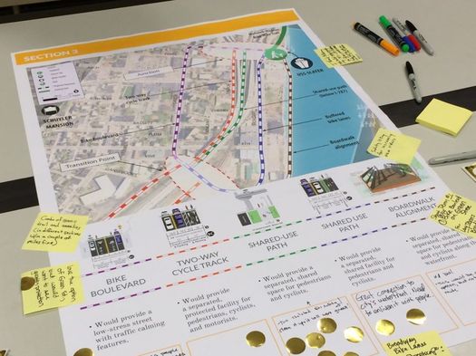
Section 2: Cherry Hill to near Island Creek Park
+ Shared-use path west: A multi-use path built alongside the street that would run up Pearl and then follow Green Street along the west side of 787.
+ Shared-use path east: A multi-use path built along the street that would run along the east side of 787 next to the railroad tracks. There's a one-way, two-lane thoroughfare there that looks like an on-ramp for 787 (and you can use it for that), but it actually is a street that leads up to Church Street.
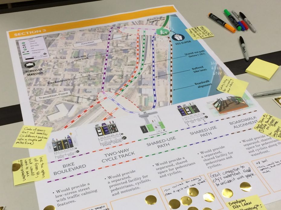
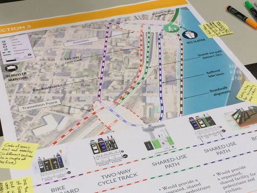
Section 3: Church Street to the USS Slater
+ Bike boulevard along Green Street: This option would route bike traffic along Green Street. And while there wouldn't be bike lanes (the diagram depicts sharrows), the planners say there would steps taken to calm traffic along the route to make it comfortable for cyclists.
+ Two-way cycle track along Church Street: Essentially a two-way bike lane along Church Street on the west side of 787.
+ Shared-use path below 787: This would involve constructing a multi-use path that would take advantage of the space below 787 (apparently there's a lot of room there that's not really being used). This seemed like an interesting idea.
+ Shared-use path along Broadway: A multi-use path built along the stretch of Broadway that passes the U-Haul building.
+ Boardwalk along the river: Construct a multi-use path on a boardwalk along the riverfront. (Just a guess on our part, but this option seems unlikely given what we suspect would be a not-small cost and complications.)
Considerations
There's probably no perfect solution for this project. And some of the tradeoffs and considerations will be the same ones that pop up on any project like this: how much funding is ultimately available, how long it would take to build, what negotiations might need to be made with property owners, and the level of safety and comfort the amenities will provide to cyclists and walkers.
But the most important and interesting consideration/challenge/question might be: How can this project be a benefit for the South End neighborhood and the people who live there?
For example: A route that traces along the east side of 787 would probably be the most direct, and if a multi-use protected is built, could also be most comfortable for cyclists. But that would also mean traveling a path that largely misses much of the residential part of the South End, and could blunt some of the project's benefits in terms of utility for people within the neighborhood -- and even economic gain for neighborhood businesses. (In her opening remarks Thursday, Kathy Sheehan noted that she sees bike infrastructure like this project in part as an economic development tool.)
Based on the Albany Bicycle Coalition t-shirts and the cycling gear in the crowd Thursday, we're guessing many of the people there were coming at this project from more of a cycling perspective. And that's OK. But it will also be important to get local neighborhood perspectives involved, something one of the planners at Alta told us they've been working on.
The network
One other, wider-picture thing: A bike path is fine. Two bike paths is better. But a system of bike paths, connecting within the city of Albany and to its surrounding areas, holds the most potential in helping foster a culture here in which a broad range of people, in a range of places, feel comfortable choosing cycling as a transportation option.
So, in some way, this is just a two-mile bike route. But its significance is greater than that because it helps connect the growing network.
What's next?
There's another public meeting about this project slated for later this summer, though the date hasn't been set yet -- the planners said it will probably be late June or sometime in July.
There's also a walking tour with planners about the potential options on Saturday, June 11. It's free to attend, though registration is requested.
And the planners are taking comments about the project via its website.
Say Something!
We'd really like you to take part in the conversation here at All Over Albany. But we do have a few rules here. Don't worry, they're easy. The first: be kind. The second: treat everyone else with the same respect you'd like to see in return. Cool? Great, post away. Comments are moderated so it might take a little while for your comment to show up. Thanks for being patient.
Comments
I'm so very grateful for the work done by the Albany Bicycle Coalition, the Mayor and all others to get these bicycle facilities going! Thanks to their hard work, the wind is changing direction. It's no longer a question of whether bicycles are going to get their place in our transportation mix--it's just a question of how fast and in what form. Thanks also to AOA for the coverage! Invaluable!
... said Randal Putnam on Jun 3, 2016 at 5:10 PM | link
I love the idea of connecting the two paths and honestly, any way it gets done that is safe and clearly marked is great. I like the idea of keeping off Pearl as much as possible. The green shared use path starting at the current trail head, and the black boardwalk path running behind the U-Haul lot branching off the buffered bike lane. seems great, although a boardwalk might be a bit pricey.
Thank you for everything that has already been done to make what is already done! it's beautiful!
... said Ryan Keller on Jun 6, 2016 at 2:01 PM | link
A safe connection achievable with available funding should be the first priority. More expensive routes such as boardwalks can come later as funding is obtained.
... said Zed Fechten on Jun 7, 2016 at 8:09 AM | link
What about my idea of having the trail run along the river to Krank park, using an open space overlay like they do in San Antonio? Water enhanced uses (restaurants, bars, apts, etc) can go behind the trail on the waterfront (only water dependant uses like the marina need the direct access to the water). I mailed a map & description to the mayors office & planning dept but I don't see it mentioned here. If San Fran & San Antonio can do it so can you Albany! Stop thinking small & start thinking big. We are NOT smallbany!!!! With the northern Catskills, southern ADK's, Berkshiers, AND Green Mountains within an hours drive (not to mention the Hudson River) we should be marketing ourselves as the place to be for the outdoor adventure crowd! They spend alot of $ on food, lodging, & area entertainment!
... said Myra on Jun 7, 2016 at 11:34 AM | link
@Myra, I think you mean Island Creek Park, Krank Park is not near the river.
If you look at the SECTION3 on the map you would notice that there is a Boardwalk Alignment (Brown) to Island Creek Park from the USS Slater.
The biggest issue is getting from Heldeberg-Hudson through the residential South End (Ezra Pentice Homes) so that it is not only Bicycle friendly but Pedestrian/Runner usable.
... said Peds on Jun 7, 2016 at 4:50 PM | link
I'm excited they see it as an economic tool.
Just rode from Voorheesville to Troy this past weekend and had lunch up there. Used both paths and scooted in between on the connector roads. There are a number of bike stores in the vicinity of the paths as well.
I saw that Wolffs had organized a ride from their Albany location up the Mohawk path to Troy with their new location. The area needs things like this.
... said K on Jun 7, 2016 at 10:58 PM | link
I prefer a shared path. Keep it off the highway as much as possible. In fact, I favor keeping it totally off the highway.
... said David Pisaneschi on Jun 9, 2016 at 8:24 PM | link
As the only significant improvement in the area's bike trails since the '80s was the reconstruction of the Black Bridge in Cohoes (and that came after I left the area), I'm inclined to shout to Albany: JUST DO ANYTHING. Planning is great with follow-through, but for the most part in the tri-cities, we just plan. And plan. And plan. And nothing happens. And when something does happen, it often makes cycling (or just plain walking) actively dangerous, as is the case with the ridiculous cobbled crossings on Pearl Street and Lark Street.
Where I live now, admittedly a major metro area, THREE bicycle crossings of a major river have opened within a year. Meanwhile, advocates of a bike crossing with a rebuilt Livingston Avenue Bridge are stuck waiting and hoping that someday somebody will convince Amtrak not to kill their idea. I have no hope there will be a crossing other than the Dunn in my lifetime.
So, Albany, DO A THING.
... said Carl on Jun 10, 2016 at 8:16 AM | link
Thanks for the shot out for tomorrow's walking tour!
... said daleyplanit on Jun 10, 2016 at 9:59 AM | link