A winter that's back to normal?

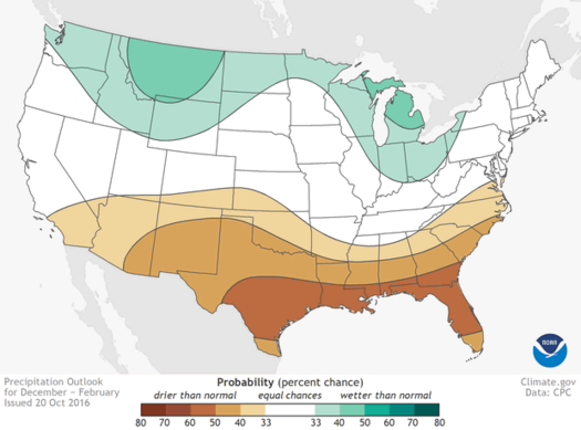
An outlook for precipitation this winter from NOAA.
Projections for what a winter is going to be like here -- especially when it comes to snowfall -- are probably best taken with some salt (because healthy skepticism and... icy sidewalks). For example: A "typical" seasonal total of snow can be tipped by a few coastal storms that just happen to track a little farther inland. You don't know until you know.
But there are some large scale phenomena that do generally point toward some sort of direction. Last year's winter is a good example: A strong El Nino -- that is, warm water off the Pacific coast of South America by the equator -- helped prompt a historically warm, un-snowy winter here.
The El Nino has ended. And for this winter we're now looking at the prospect of La Nina -- basically the inverse of El Nino -- influencing things. Maybe.
From the US Winter Outlook released Thursday by NOAA:
Forecasters at NOAA's Climate Prediction Center issued the U.S. Winter Outlook today, saying that La Nina is expected to influence winter conditions this year. The Climate Prediction Center issued a La Nina watch this month, predicting the climate phenomenon is likely to develop in late fall or early winter. La Nina favors drier, warmer winters in the southern U.S and wetter, cooler conditions in the northern U.S. If La Nina conditions materialize, forecasters say it should be weak and potentially short-lived. ...
This seasonal outlook does not project where and when snowstorms may hit or provide total seasonal snowfall accumulations. Snow forecasts are dependent upon the strength and track of winter storms, which are generally not predictable more than a week in advance. However, La Nina winters tend to favor above average snowfall around the Great Lakes and in the northern Rockies and below average snowfall in the mid-Atlantic.
Boiled down a lot for this part of the country: La Nina winters tend to include colder temperatures and more snow around the Great Lakes (sorry, Buffalo).
But as a good video posted with the winter outlook explains, the La Nina is projected to be relatively weak, so it might not shift the probabilities much (the video is embedded above). In fact, NOAA has this part of the country pegged as having an "equal chance" of below average, average, and above average winter temps and precipitation. (Though earlier this year Eric Holthaus at Slate noted that El Nina winters tend to mean fewer big blizzards along the East Coast.)
Typical winter?
Last year's seasonal snowfall total for Albany was just 16.7 inches, one of the lowest totals on record -- and way off the typical total. The 30-year normal season total is 60.3 inches.
image: NOAA
Hi there. Comments have been closed for this item. Still have something to say? Contact us.
Comments
"Phenomenon" should be "phenomena" (since it's plural).
Greg: Thanks for catching that. It's Greek to me.
... said Correction on Oct 21, 2016 at 9:08 AM | link