Snowy, in a normal way

Albany snowfall this winter so far.
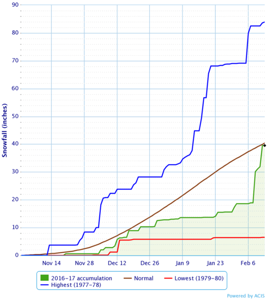
That graph above shows the snowfall accumulation for the Albany area this winter (green) versus the 30-year normal (brown), the record high (blue), and the record low (red). (That graph was generated by the NWS Albany website.)
So, yeah, the last few storms have caught things up with the normal pace quite a bit. As the NWS Albany Facebook page points out today (with even more up to date figures), the 20.6 inches this area has gotten in the last four days equals all the snow it had gotten previously this winter. And the seasonal total is now just slightly ahead of the normal.
The 30-year normal seasonal snowfall here is a little more than 60 inches. But the variation season to season is wide, something that was clear when we recently looked at 120 Albany winters. That we're coming off an exceptionally weird winter last time around -- it was very warm and un-snowy -- maybe makes all this recent snow feel unusual. But it's not, really. Upstate's gonna upstate eventually. (Probably.)
NWS Albany
By the way: This seems like as good a time as any to point out that the National Weather Service Albany posts all sorts of interesting forecast and historical info on its website and Facebook page. The NWS website hasn't always been the easiest to use -- it's gotten a bit better -- but if you're looking info with out all the hype, it's a go-to option.
We've become fans of the probabilistic forecast page, which give a better sense of what, say, a forecast of 6 inches of snow means. And if you're just a general weather nerd, the NWS Albany Facebook page post a steady stream of local weather bits.
... said KGB about Drawing: What's something that brought you joy this year?