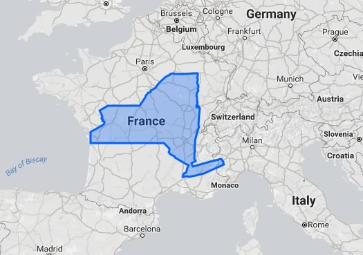
The true size of New York State

A little goofy, but what good is the internet if you can't superimpose the borders of states and countries onto other states and countries to get a sense of their relative sizes during an afternoon lull.
A site called The True Size allows just that. So, of course, we selected New York State and moved it around the world. See the screengrab above.
By the way, one of the interesting things about that site is the way it highlights how map projections affect the size of countries. As you move New York State north and south around the world, its outline grows, shrinks, and warps.
[via @yayitsrob]
Hi there. Comments have been closed for this item. Still have something to say? Contact us.
Comments
Very cool.
Here is another interesting geography comparison I've come upon recently. The hardiness zone of Albany is similar to....Russia! Albany is now zone 5b, like St. Petersburg (which is near Finland). I don't know why I thought we would be like France or Germany, but those countries are akin to Virginia. So those of us anxious for the soil to warm up and the gardening season to hit its stride, we're in Russia.
... said chrisck on Apr 19, 2017 at 2:14 PM | link
to follow up on chrisck's comment...
Plattsburgh is at about the same latitude as Minneapolis, MN; Bordeaux, France; Bologna, Italy; Bucharest, Romania; and northern tip of the Japanese island of Hokkaido.
Albany is at the about the same latitude as fellow state capitol Lansing, MI; the island of Corsica; Sofia, Bulgaria; and the very northern tip of North Korea.
Rockaway Beach is at about the same latitude as Fort Collins, CO; Ferndale, CA; Guarda, Spain; Baku, Azerbaijan; and the northern tip of the Japanese island of Honshu.
... said -B on Apr 19, 2017 at 4:44 PM | link
I was playing around with the 'True Size' website, and New York just ate Connecticut, Massachusetts, Rhode Island, Vermont, and New Hampshire. Then it burped up New Jersey....
... said Bob on Apr 19, 2017 at 6:01 PM | link