A potential map for Troy's future
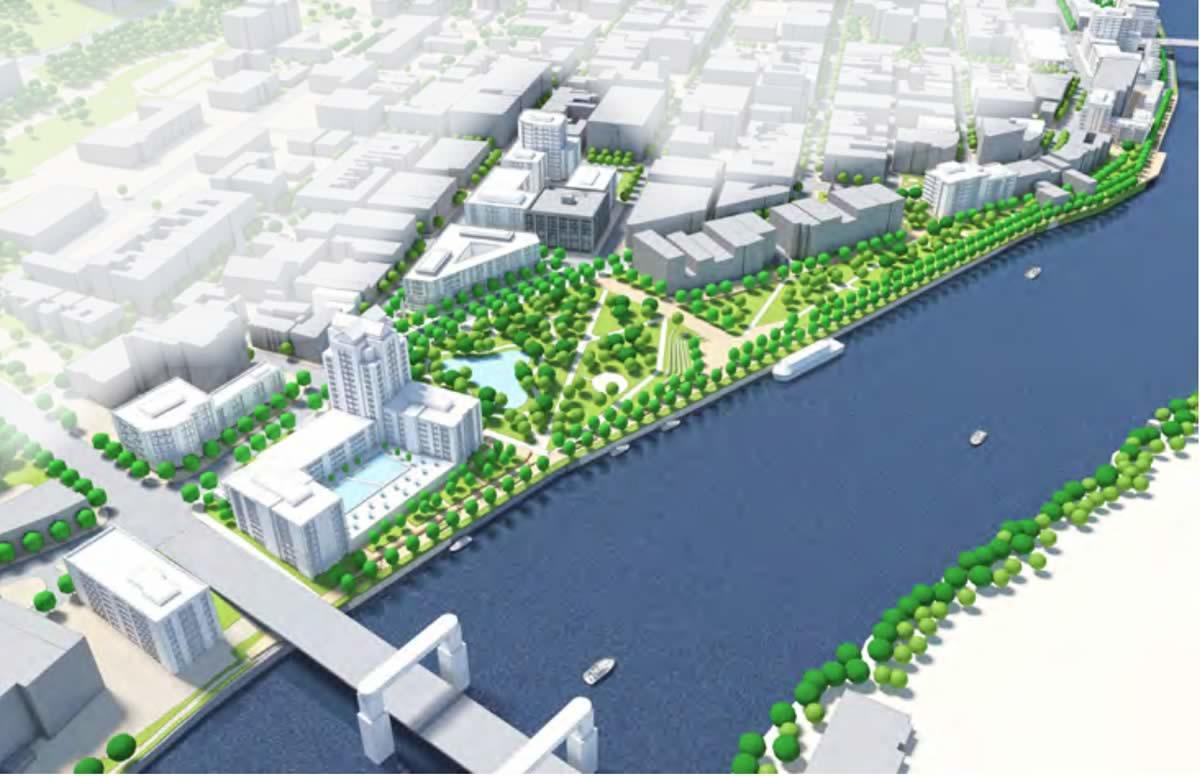
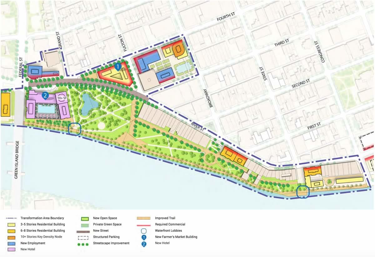
A conceptual plan for a reconfiguration of the riverfront in downtown Troy.
The draft of Troy's new comprehensive plan -- Realize Troy -- was released this week after more than two years in the making. It's basically a proposed road map for the city's future over the next 25 years and beyond.
The full draft is available over at the Realize Troy site.
We read through the plan this week and picked out a handful of bits that caught our eye -- from a major reconfiguration downtown to... forks.
This isn't a comprehensive scan of the whole plan. There will no doubt be things that you notice or highlight as important that are not mentioned here, and in that case we encourage you to note them in a comment.
Click on each image for a larger view.
Overview
How the plan's authors describe the plan itself:
The Realize Troy Comprehensive Plan (the 'Plan') establishes this vision, strategy and framework. It is a blueprint for community transformation aimed at enhancing prosperity, community well-being and the quality of life and opportunity the City of Troy offers its citizens. This Plan identifies city-wide networks, systems and policies to support the city's waterfront, foster a thriving city center, and strengthen and promote the city's diverse neighborhoods. It will also help focus and align public and private sector initiatives around a set of common goals aimed at becoming a more attractive and vibrant city with a distinct role within the region. [pdf p. 3]
A quick clip from the section about how it's intended to be used:
This Comprehensive Plan provides a framework to guide new development and transformation in the city over the next 25 years and beyond. It will be used by the City to guide land use decisions and to seek funding and support for key infrastructure and capital improvement projects. Neighborhood groups and nonprofits will use it to seek funding as well. It will also provide developers with an understanding of the City's development priorities by identifying and illustrating the scale and form of new development that may occur in designated Reinvestment Areas and in other areas throughout the city. Information on projects/programs should be interpreted as guidance to the City, property owners, developers and future residents. The exact location and timing of public investment will be subject to future detailed analysis, design, and capital budget approvals. [pdf p. 10]
OK, onto a few things that caught our eye...
The riverfront
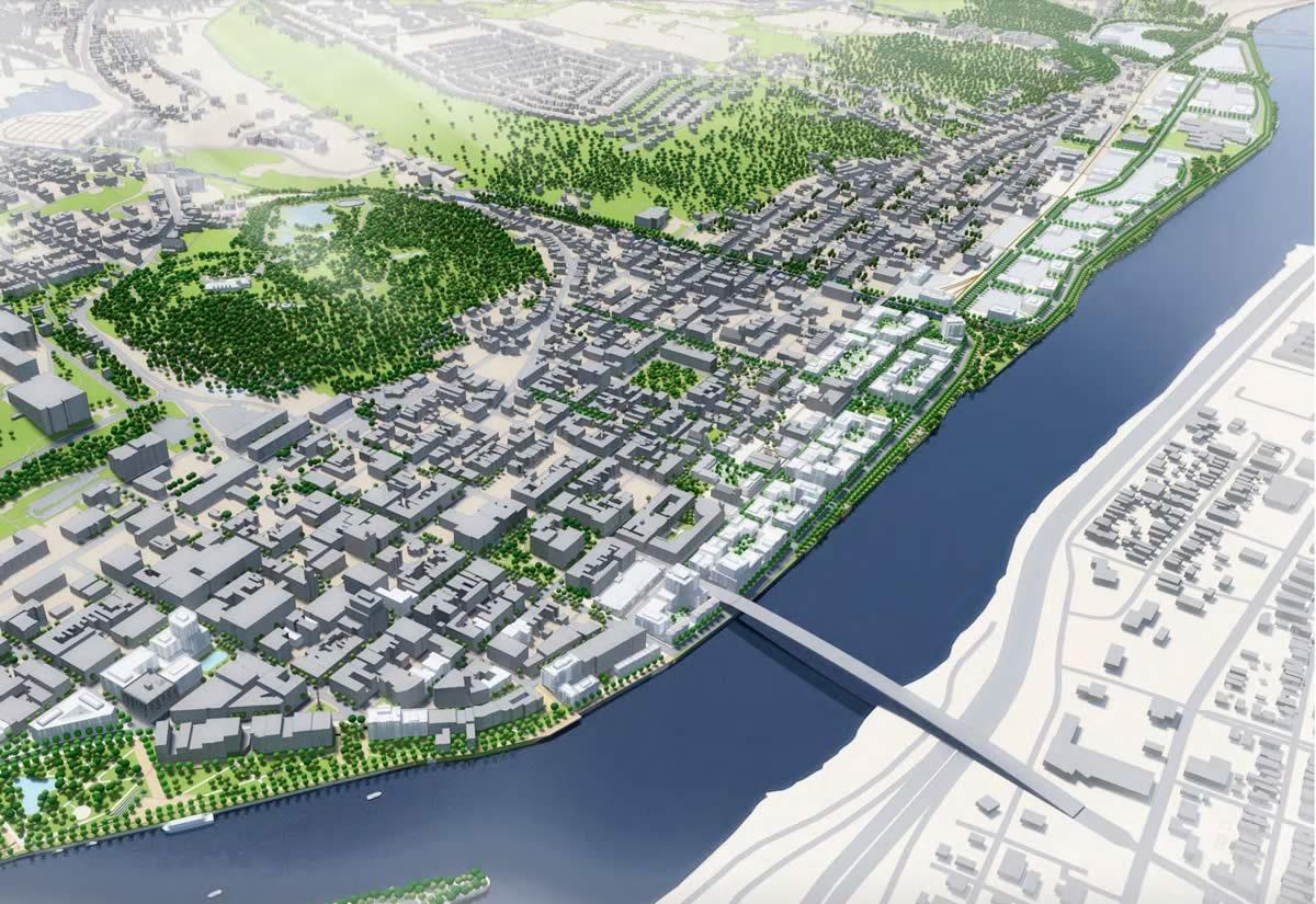
A recurring theme through the draft plan is a goal to make better use of the Troy's extensive riverfront -- providing greater public access, setting opportunities for development, and increasing resilience for dealing with future flooding.
Toward that end, the plan proposes the creation of linear parks along the riverfront in multiple neighborhoods, ranging from Lansingburgh, to the city center, to areas of south Troy.
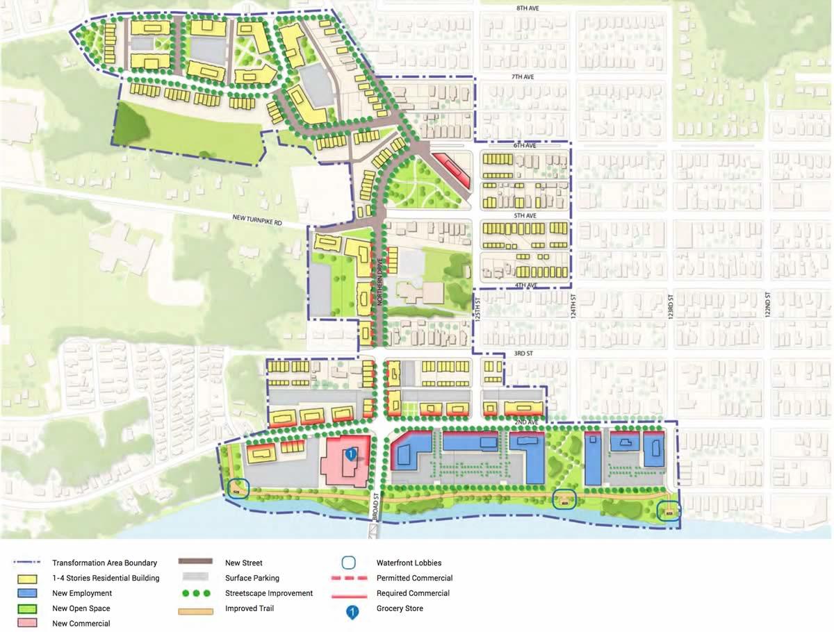
It also calls for the creation of "waterfront lobbies," a term that's new to us: "Spaces along the water's edge that are located at the end of public streets and provide opportunities for enhanced recreational enjoyment and public access to the waterfront." [pdf p. 59]
And this bit, about the current riverfront, stuck out (emphasis added): "A major challenge in the city is the lack of access to the waterfront by land and water. Nearly 25% of the city's riverfront properties are currently in use as surface parking lots, and more than 30% of Hudson River frontage is occupied by vacant parcels." [pdf p. 25]
Mixed use
As part of the plan's aim to "promote healthy, safe, and green neighborhoods," it calls for the creation of new mixed-use areas around the city. "The creation of new areas for mixed-use development with a range of housing choices will support new home ownership and rental options which are needed to keep established neighborhoods healthy" [pdf p. 40]. Mixed use can mean a range of things, but one example is, say, a building with retail on the first floor and residential on the upper floors.
To go along with the mixed-use goal, the plan also calls for the encouragement of diverse types of housing, ranging from town homes, to apartments, to live-work spaces, to affordable housing mixed in with market-rate housing. [pdf p. 41]
Lansingburgh / Knickerbacker Park
The comprehensive plan identifies four "major reinvestment areas," with longterm conceptual plans for making over those sections of the city: Lansingburgh, North Central, the City Center, and the South Waterfront.
The plan for Lansingburgh includes two large potential changes:
126th Street District
A realignment of 126th street so that it leads from the Troy-Waterford Bridge up to Northern Drive with the hope of creating a mixed-use corridor: " The realignment of 126th Street will help establish a logical and direct connection in and out of the city. It will also provide the opportunity to link the two commercial nodes to create one larger mixed-use district with the extension of 126th Street as the mixed-use and commercial spine. Over time, commercial uses will be replaced by new mixed-use buildings with an improved relationship to the street by framing the street and public realm to support an attractive pedestrian environment. Small-scale parks throughout the district will create gathering places for civic and social functions for people of all ages. A continuous waterfront trail will stretch from 123rd Street linking across the Waterford Bridge to include the river frontage along the Hannaford Supermarket." [pdf p. 78]
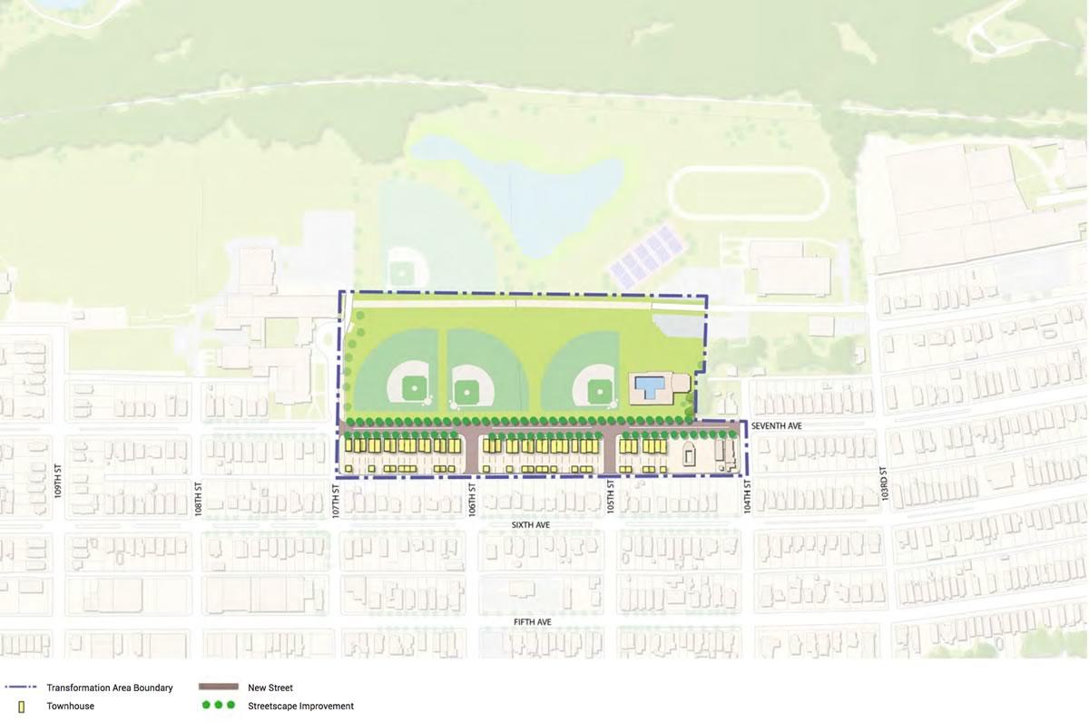
Knickerbacker Park Reconfiguration
And a reconfiguration of Knickerbacker Park that would reconnect 7th Avenue. "The reconfiguration of the Park and reconnection of 7th Avenue will improve the interface with the park by developing uses that front, as opposed to back onto the park, improving visibility and enhancing safety for park users. Converting the portion of the park west of the new road on 7th Avenue into new residential uses would bring significant investment to this neighborhood and would support neighborhood renewal and lend greater stability to the area. This would also provide an opportunity to develop a greater diversity of low density housing in the eastern part of the Lansingburgh neighborhood, including townhouses and semi-detached units." [pdf p. 82]
Downtown riverfront reconfiguration
Another identified reinvestment area is the city center, and the plan proposes a large-scale reconfiguration of the area just south of the Green Island Bridge:
The Riverfront District will leverage this reinvestment by significantly expanding the park and adding new recreational, entertainment and tourism uses to strengthen the waterfront as a focus for culture, visitation, recreation, and social interaction. Riverfront Park will be expanded from State Street to Grand Street and will be supported with new park programing, a new public marina in the park, a new landmark hotel/residence and convention facility on the waterfront with a public parking component. The new signature hotel/residence and conference facility will be developed at the entry point to the downtown at the intersection of the Green Island Bridge and River Street. The District will also include the establishment of a permanent home for the Farmer's Market within a new mixed-use building that fronts the park expansion. Uncle Sam's Atrium may be redeveloped into a mixed-use building with the potential for a small mid-sized cinema to better support the city center as a cultural and entertainment destination. The vacant land at Monument Square will be filled in with a ramped park space and additional mixed-use buildings that will serve to add more people and activity to the core of the city. [pdf p. 98]
Among the many aspects of this area-specific plan: The hotel would be a "mid-rise building of six to eight-stories will feature a signature tower element of up to 25-stories."
This idea has been in circulation for a long time -- it was part of preliminary presentations back in the spring of 2016.
The comprehensive plan also proposes further reconfiguration farther south along the riverfront near Sage in the "Riverside District," calling for a linear park, changing the ramps to/from the bridge, and redeveloping the sites owned by the Troy Housing Authority. [pdf p. 104]
Regional commuter station
The plan mentions the possibility of a regional commuter station that would use the existing rail line from south Troy to the Albany-Rensselaer Amtrak station to "help better link Troy to the City of Albany and
other significant destinations." [pdf p. 21] This idea doesn't get a lot of attention in the plan, but it is pitched a few different places.
Forks
Compared to those major reconfigurations, this idea is small, but it struck as interesting and accomplishable in the near term: The comprehensive plan calls for the places where streets "fork" to be turned into small parks. "The forks are important places to enhance the character and desirability of Troy's neighborhoods by creating small, attractive gathering places where the intersection of roadways create a triangular open space. Enhancing these with seating, street tree planting, landscaping and public art will emphasize the importance of a socially inclusive city. The City should utilize Community Block Grants to develop and enhance the series of neighborhood forks identified in this Plan. Locations where existing or proposed capital works, Land Bank activities or neighborhood revitalization initiatives are already underway should be prioritized." [pdf p. 122]
UNESCO World Heritage Site
As part of its section on encouraging tourism, the plans calls for the city to pursue a UNESCO World Heritage Site designation. "Troy has one of the most intact 19th century downtowns in the U.S., and on its face it meets UNESCO's selection criteria. Pursuit of a UNESCO designation could be expanded to include designation for the Erie Canal as well. There are no other UNESCO heritage sites designated in the northeastern U.S., which would differentiate Troy from other historically and architecturally significant communities." [pdf p. 95]
This seems like a bit of a stretch -- there aren't all that many in the entire United States -- but if successful, it'd be interesting to see how that changes perceptions of Troy.
Public meetings
The draft plan will be up for public discussion at two meetings of the Troy Planning Commission -- February 21 and then again in March. And the Troy City Council will have a public hearing April 5 ahead of a vote to adopt the plan.
Say Something!
We'd really like you to take part in the conversation here at All Over Albany. But we do have a few rules here. Don't worry, they're easy. The first: be kind. The second: treat everyone else with the same respect you'd like to see in return. Cool? Great, post away. Comments are moderated so it might take a little while for your comment to show up. Thanks for being patient.
Comments
I understand the general idea of the plan, but some of the elements are so off target it makes me wonder why Troy spent so much money on a report that proposes many things based solely on conjecture. The city needs realistic planning, not architectural fantasy. The comprehensive plan should be based on establishing solid foundations, then those areas can grow to a secondary level creatively. Zone properly, provide reliable infrastructure, good streets, lots of green space. Then let the market take over.
... said ace on Feb 9, 2018 at 10:28 AM | link
I like the ideas here and I hope they can be realized. I like that they are looking outside of downtown. I'd love to see the waterfronts better utilized in both North and South Troys. I don't know how they'll make that actually happen with the businesses in the South and the way things are currently situated in the North, but I don't think it's impossible.
I also love the idea of applying to be a UNESCO site. It's not your traditional UNESCO site but I think Troy certainly is just as beautiful and as historically important as other sites I've visited.
I'll be at that February meeting. Looking forward to hearing more discussion on this.
... said Danielle Sanzone on Feb 9, 2018 at 1:27 PM | link
Haven't looked at the plan beyond AOA's bullets, but Ace is 100% right. Proposal for immediately south of GIB is absurd, did they talk to any of the stakeholders? Doesn't really mesh with CDTAs plans. The lansingburgh items look more realistic.
... said Ed on Feb 9, 2018 at 2:02 PM | link
@ace
The first step in city wide re-visioning is a comp plan. Then a rezoning to put that plan into place. There are goals, and then there are rules. Goals tell you where you want to go - rules tell you how to get there.
... said Daleyplanit on Feb 9, 2018 at 5:05 PM | link
No snark intended but did I miss what's supposed to happen to dinosaur bbq and why it's getting replaced with a big hotel?
... said Jason on Feb 9, 2018 at 6:14 PM | link
Any plan for the city has to first deal with citizen safety. As a former resident, I hope this plan works better than the plan that gutted the downtown and replaced it with the Atrium. Businesses moved out and never returned.
... said Bob Hoffmeister on Feb 10, 2018 at 9:09 AM | link
Any plan that envisions greater recognition of the aesthetic value of the waterfront is to be applauded. As a transplant to Troy I have been bewildered by how the city seems to turn its back on the river.
... said Wesley on Feb 16, 2018 at 9:02 AM | link