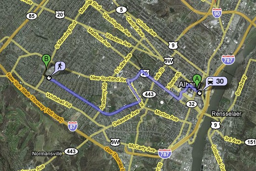
Google Transit makes a stop in the Capital Region

The downtown Albany to St. Peter's example.
As ThisQualityLife reported in a comment earlier this week, coverage of the Capital Region on Google Transit started today. And it is pretty cool.
You plug in where you're at, where you want to go, and Google figures out which bus to take, how far you'll have to walk, and how long the whole trip will probably last. (Check out this example for a trip from downtown Albany to St. Peter's.) Another interesting feature is the ability to plan/map a trip if you just want to walk. (See that same downtown to St. Peter's trip via foot.)
We can see this being really helpful for bus riders -- especially people who ride only occasionally (it's probably easier than getting a coach). But even if you never ride the bus, it's kind of fun to play around with these maps.
Say Something!
We'd really like you to take part in the conversation here at All Over Albany. But we do have a few rules here. Don't worry, they're easy. The first: be kind. The second: treat everyone else with the same respect you'd like to see in return. Cool? Great, post away. Comments are moderated so it might take a little while for your comment to show up. Thanks for being patient.
Comments
started today? this has been up for a month!
... said bill on Aug 1, 2008 at 10:48 AM | link
@Bill: Weird. When we tried it yesterday, it wasn't working (and Albany still doesn't appear on the Google Transit list of cities served). The transit info has been embedded on the maps for a while, but this was the first time we the routing worked for us.
... said Greg on Aug 1, 2008 at 12:28 PM | link
admittedly, i haven't been a regular user for a month, but while trying to figure out bus directions from troy to albany in early july, i wound up using this feature. perhaps it was in an early form of testing back then....
... said bill on Aug 1, 2008 at 1:34 PM | link
You're ahead of the curve!
... said Greg on Aug 1, 2008 at 1:55 PM | link