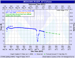
The Mohawk's ups and downs
 Summer's comment about the Mohawk this morning prompted us to go looking for info about the river's water levels. And, as it turns out, there's a bunch of data posted on online -- something to keep in mind if you're a boater, fisherperson or other river user of some sort.
The US Geological Survey posts some pretty simple river level graphs created from data taken at a station in Cohoes. And the National Weather Service uses that data to create a whole bunch of graphs, charts and forecasts for points in Schenectady and Cohoes.
Bonus river data: the USGS service that tracks the Mohawk also tracks rivers and streams all over the state. As you might expect, this list includes the Hudson (here's the reading near Green Island) -- but also smaller streams such as the Normanskill.
Mohawk graph: National Weather Service
Say Something!
We'd really like you to take part in the conversation here at All Over Albany. But we do have a few rules here. Don't worry, they're easy. The first: be kind. The second: treat everyone else with the same respect you'd like to see in return. Cool? Great, post away. Comments are moderated so it might take a little while for your comment to show up. Thanks for being patient.
Comments
This is really cool. It looks like lakes and reservoirs are listed there too. Here's data for Sacandaga Lake:
http://waterdata.usgs.gov/ny/nwis/uv?site_no=01323500
... said Paul on Jun 1, 2009 at 2:33 PM | link
Thanks for posting that. If more people took a moment to check the data before heading out on the water for whatever reason, perhaps some lives could be spared. I know I'll be keeping an eye on it.
... said Summer on Jun 1, 2009 at 3:17 PM | link