Reconfiguration of Washington and Fuller starts

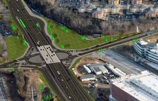
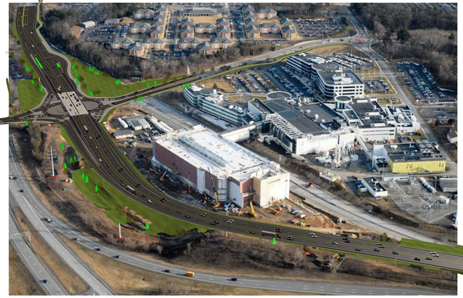
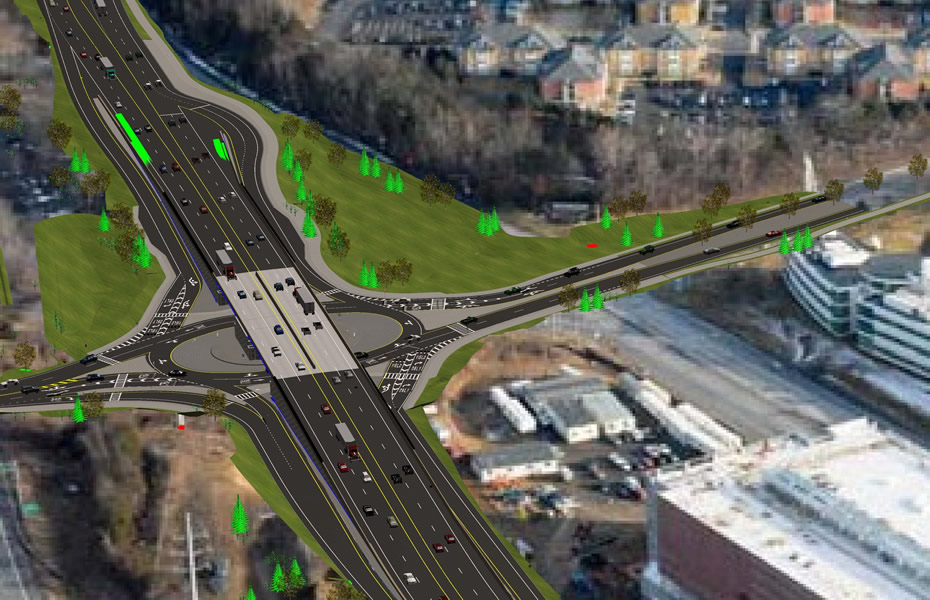
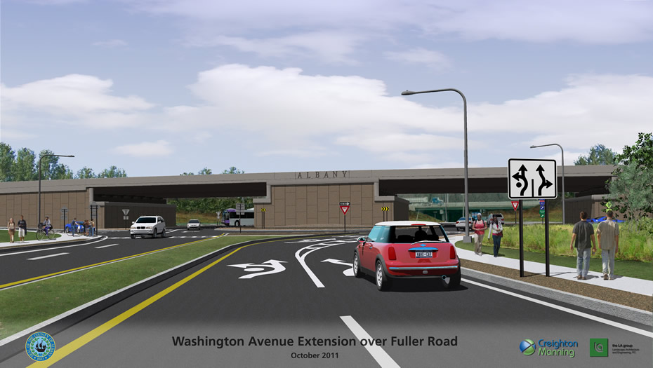
A rendering of the what the reconfigured intersection will look like.
The state Department of Transportation announced today that the realignment of the Washington Ave Ext/Fuller Road intersection has started. (You might have noticed the recent tree clearing around the site.) From the press release:
NYSDOT will realign Washington Ave. Ext. to the north and install a two-lane roundabout at the Fuller Road/County Road 156 intersection. A flyover bridge will be built to carry through-traffic, thereby removing 20,000 cars daily from the intersection and providing improved access to CNSE's Albany NanoTech Complex, which is currently engaged in a $366 million expansion project. Nearly 30,000 vehicles travel through the intersection each day.
Pedestrian and bicycle access will be improved with new sidewalks and a new, 10-foot bicycle lane that will connect to existing bike trails. Reduced congestion will enhance transit schedules; new bus bays on Washington Ave. Ext. will provide safer stopping areas for riders.
Most of the work can be done without impacting traffic. More than 3.5 miles of Washington Ave and Washington Ave. Ext. will be reconstructed, together with a half mile stretch of Fuller Rd.
NYSDOT says it's an $18 million project, funded by the Fuller Road Management Corporation -- a not-for-profit org created to manage the nanotechnology facilities at UAlbany's CNSE -- Albany County, and the state. It says FRMC is picking up 45 percent of the cost.
The project is expected to be "substantially completed" this fall -- with minor work on Fuller Road next summer. The re-alignment will open up more space for Albany NanoTech. (The area under the bridge that currently spans Wash Ave Ext will become a parking lot.)
Large-format renderings are after the jump.
So, what's this intersection called? We were hoping that a flyover bridge over a roundabout had a special name or transpo planner slang -- you know, like SPUI. So we checked with NYSOT spokeswoman Carol Breen -- and, alas, it does not. Of course, that's an opportunity to coin one. Florcle? FlyAbout? Roflyover?
The large-format renderings are at the top of this page -- scroll all the way up.
renderings via NYSDOT
Earlier on AOA:
+ The NanoBridge over Washington Ave Ext
+ What's up at Washington and Fuller?
Find It
Washington and Fuller
Washington Ave Ext and Fuller Road
Albany, NY 12203
Say Something!
We'd really like you to take part in the conversation here at All Over Albany. But we do have a few rules here. Don't worry, they're easy. The first: be kind. The second: treat everyone else with the same respect you'd like to see in return. Cool? Great, post away. Comments are moderated so it might take a little while for your comment to show up. Thanks for being patient.


Comments
Notice the little red car with a license plate that reads "Nano Car."
Regardless, I think the County and the City needs to be wary of giving such broad leeway to NanoTech to push development or realignment simply to cater to itself.
... said Sean Collins on Apr 12, 2012 at 4:57 PM | link
An AntiLatham? (Looks a little like the reverse of Latham Circle.) Or wait... how 'bout we just call it what it looks like, a Cluster?
... said KB @ Home-Baked Happiness on Apr 12, 2012 at 5:07 PM | link
So they're suggesting that bicyclists use the sidewalks? See the street-level view. Not seeing any bike lanes in the others either. Am I missing something?
... said Rich on Apr 12, 2012 at 5:15 PM | link
Don't think there's a name, but based on prior experiences with this configuration, I'm a little terrified: http://en.wikipedia.org/wiki/Somerville_Circle
... said Pete on Apr 12, 2012 at 5:22 PM | link
@Rich I saw that too. There is what looks like a 1-2 foot shoulder. If you're brave.
... said ethan on Apr 12, 2012 at 6:14 PM | link
Personally, I can't wait. I hate waiting for those lights... Yes, I'm very impatient. =D
... said Andy on Apr 12, 2012 at 6:48 PM | link
I second the notion that those bike lanes don't appear to be there. I would be really disappointed if we sink millions into another infrastructure project in this region that gives token reference to pedestrian/bike friendly access and once complete is no where near that truth. I work in the area and would love to have a more bike friendly commute.
... said Rich on Apr 12, 2012 at 7:31 PM | link
how about flotary? or fly-otary?
... said ken on Apr 12, 2012 at 8:36 PM | link
Like the lanes on Hoosick Street, and near the Latham interchange, no one will ever use those bike lanes. Why build them?
... said Wanttobeanonymous on Apr 12, 2012 at 8:42 PM | link
I'd love to see a complete accounting of the bike/pedestrian features of this planned intersection. Is that available anywhere, in detail? This intersection is on my main bike route from Schenectady to Albany. Western and Central at the Northway are non-starters, especially eastbound in rush hour, but this one always worked. I used to ride the Wash Ave Ext service road til it ended, then continued on Wash Ave Ext to Fuller and beyond on Wash Ave and downtown. With Wash Ave Ext to now apparently ban bikes, that means the bike path from Rapp to Fuller, and then what? They mention a connection with existing bike paths, but the how and where need to be spelled out.
... said Rich on Apr 12, 2012 at 10:37 PM | link
LOL, as if people will actually walk there.
I dont even see whats wrong with the existing intersection style, ive never had a problem driving through there.
This is some awful sprawl. $18 million? Seriously?
Oh I see... the nanotech is paying for it.
... said BBnet3000 on Apr 12, 2012 at 11:52 PM | link
I agree with KB. It looks like the Latham Circle, only with the through road on top rather than underneath.
... said Tim in Waterford on Apr 13, 2012 at 1:55 AM | link
I have been following this development for some time, and I still find the whole thing bizarre. Why was the new nanotech facility built so close to a major roadway, with all the vibrations from traffic, in the first place? Why couldn't they build it on the main university campus, on state land, or even on Railroad Avenue (which is sorely in need of redevelopment) instead of on a greenfield site? It appears that Six-Mile Waterworks (aka Rensselaer Lake) is being reduced to a little pond stuck between two major roads. You may as well have a garbage dump there... oh yeah, there's already one nearby. So much for saving the Pine Bush.
I disagree with BBnet3000 that people don't walk in this area. I often see SUNYA students walking along the shoulders of Washington Avenue Extension to reach Crossgates... not exactly safe for pedestrians.
... said Ellen on Apr 13, 2012 at 8:49 AM | link
Oh, by the way, it's the state Department of Transportation, not Department of Transit.
AOA Greg: Erf. Of course. I had transit stuck in my mind from the previous post. Eventually there's going to be a post where every topic runs into every other topic. Jim Tedisco's going to be hugging corgis while riding on a bike lane through Craigslist.
... said Ellen on Apr 13, 2012 at 8:51 AM | link
I agree with BBLnet3000- the last rendering made me laugh. The thought that this intesection will get as much foot traffic as is depicted in this image is a bit optimistic.
... said Jules on Apr 13, 2012 at 9:12 AM | link
Anything on Washington Ave. west of 85 has always screamed to me that pedestrians and cyclists are persona non grata. This sure doesn't change that impression.
... said James on Apr 13, 2012 at 9:14 AM | link
People said the same thing about adding sidewalks to 9/20 a decade ago: "Why would you do that? No one walks there!" Of course they didn't when it was dangerous, and of course they will when it's not. Wouldn't it be pleasant to be able to get from SUNY or the surrounding neighborhoods to Six Mile Waterworks without taking your life in your hands?
This is a massively critical intersection for bicycle travel. There is no other practical crossing of I-90 or way to connect the Western Avenue and Central Avenue corridors between I-85 and New Karner Road. Fuller Road has been too dangerous for too long, and given its critical importance, it's time to accommodate travel that isn't by car.
... said Carl on Apr 13, 2012 at 10:11 AM | link
@Ellen I understand (and share) your frustration with endless road-building projects but I can't see that *this project* adversely affects the Pine Bush or Rensselaer Lake. As far as I can see, the strip of land the road is moving onto is a tiny area between the new Nanotech building and I-90 - hardly wilderness. Rensselaer Lake is on the other side of the highway - as you say already surrounded by major roads.
... said the_exile on Apr 13, 2012 at 10:39 AM | link
I drive by this everyday going East on I-90. Here's what I can't visualize: what the hell are they going to do with the high voltage power lines currently running along side the highway. Best I can tell, the new road will run right where the big metal polls now sit. Those things can't be easy to move.
Does anyone know that, I'm really curious?
... said FAU on Apr 13, 2012 at 10:44 AM | link
if they had just plowed under the state campus they could of had an endless supply of space to grow this project.
inefficent politicians stuffed this project into a small space , now look at what they have to spend. at least they can still go straight up to expand in the future, untill it impeads plane flight and they have to move the airport.
... said waste on Apr 13, 2012 at 11:16 AM | link
The Capital Region has some of the most poorly-designed highways and interchanges I've ever seen, and the growth of traffic in recent years certainly hasn't helped.
(Bonus question: How much crack must an engineer smoke to design I-90 onramps to curve in the WRONG direction, counter to traffic flow, necessitating a full >360 degree loop? Not just once but for every westbound onramp?)
The region in question DESPERATELY needs this redesign. Frankly so does the intersection just to the east in front of UAlbany. And the interchange between 7 and the Northway. Etc.
... said bk on Apr 13, 2012 at 11:44 AM | link
This looks like serious traffic trouble to me. Bridges themselves slow people down, and even after a few years of dealing with roundabouts in this area, most people still don't know what to do with them. This is going to be an avoid-at-all-costs intersection.
... said Casey on Apr 13, 2012 at 11:55 AM | link
I have to concurr that those who see this as a pedestrian wasteland aren't paying attention. As a biker (and occassionaly driver) I encounter tons of runners and walkers, primarily those from SUNY Albany. With the addition of "walkable" sidewalks along Fuller Rd to Stuy Plaza in the past two years, I've also seen a huge uptick in pedestrian traffic along that route and see that spilling over here with proper pedestrian/cycling options.
Also, while I agree that it was poor planning to squeeze the NanoTech sprawl in such a small (and on an undeveloped piece of the rare Pine Bush) space, I don't see it being the be-all-end-all for this endeavor, which will most likely start to spill over to the Harriman State Campus (where it should have started), hopefully, putting some much needed property on the City tax rolls. As a state worker who works on the State Campus, it would be great to be relocated downtown in some of our unused OGS spaces and much closer to my home. I'm sure Cuomo is ontop of that with the latest state agency reshuffles.
... said Rich on Apr 13, 2012 at 12:56 PM | link
When I used to work in Stuyvesant Plaza we would often see "Nano Geek" cruising the plaza in his Ferrari...just going around and around..(which everyone knows is super cool and a surefire way to attract hot chicks) .I think he probably had a say in making this a roundabout.
... said Rebecca on Apr 14, 2012 at 8:34 AM | link
To clarify what I said, I am not opposing sidewalks or even saying that people dont walk there (I have walked and ridden a bike between Crossgates and SUNY plenty of times).
It is still fairly rare for people to walk there, and the type of land use that this interchange encourages and enables means that the trend for walking in this area will be down, not up.
... said BBnet3000 on Apr 14, 2012 at 2:14 PM | link
I thought this article about what happens when roads are designed on the assumption that nobody wants to walk along them are built was timely and germane.
... said B on Apr 16, 2012 at 1:39 PM | link
Roundabouts don't get bike lanes because roundabouts with them have more car-bike crashes.
If properly designed, motor vehicles will be slowed to 15-20 mph. Experieced cyclists can ride through as vehicles. Inexperienced ones can go up onto the sidewalks and use the crosswalks
... said Z. Fechten on May 8, 2012 at 8:07 AM | link
Is it possible to label some of the major roads? The maps above are very confusing.
... said Mary Ellen Tardiff on Aug 13, 2012 at 3:00 PM | link
KB said, "how 'bout we just call it what it looks like, a Cluster?"
Obviously it's going to be a giant clusterflorcle.
... said g33kboi on Aug 16, 2012 at 3:08 PM | link