What if Albany is upstate, but not "Upstate"?

What are we really talking about when we use the term "Capital Region"? Is it a geographic place? A population of people? A set of economic connections? A culture?
That's one of the questions we were thinking about while looking over a recent attempt by researchers to define megaregions and lay out a "functional economic geography of the United States." The work -- by Garrett Dash Nelson of Dartmouth and Alasdair Rae of the University of Sheffield (UK) -- takes a ton of Census data about commuting patterns and processes it into a series of maps. It's published in PLOS One.
So, let's have a look at those maps for this area, along with a few thoughts about the results.
Look up
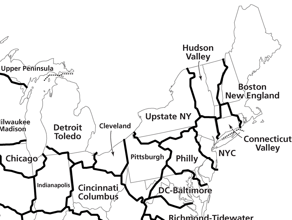
Map clips are above in large format -- click or scroll all the way up.
About the maps
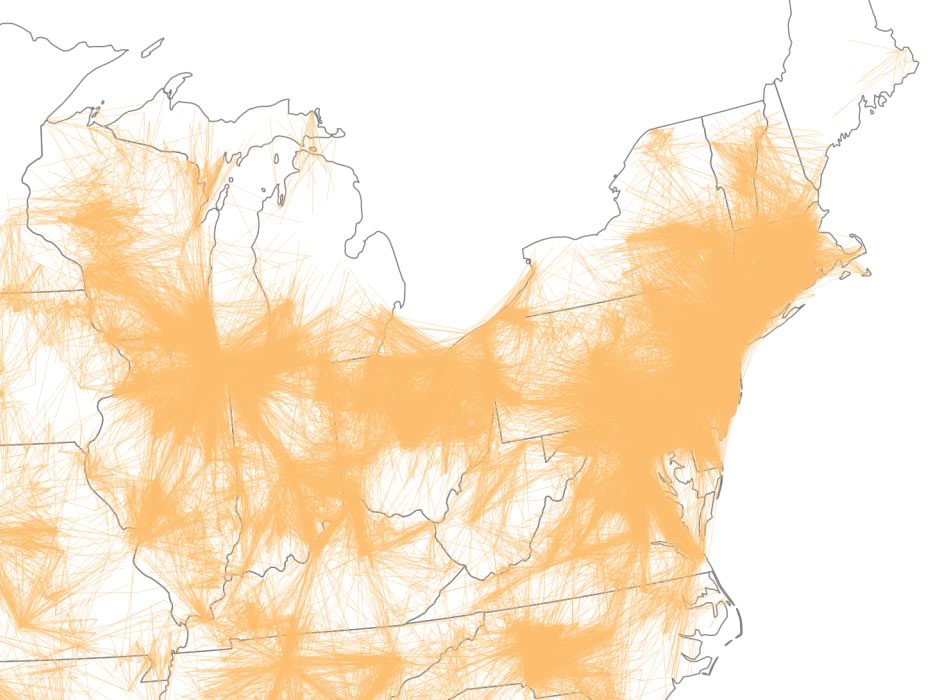
As mentioned, the researchers used Census data from 2006-2010 for commuting trips between census tracts. And they processed and analyzed this data using a variety of mapping techniques and algorithms. In fact, a large part of the paper is about the various strengths and weaknesses of these approaches. Boiled down a lot, the researchers basically conclude there's no single best way to do this, but they've tried to use a set of techniques to create maps that are helpful.
The full (open) version of the paper walks through these details and also includes full national maps.
And for a quick, not very technical overview of the paper, Wired has a write-up.
A few things
The structure of the Capital Region
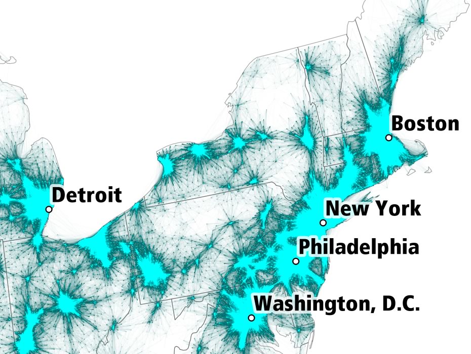
One of the defining geographic characteristics of the Albany metro area is that it doesn't really have a clear, single center. So the "shape" of this region is a streak stretching from Glens Falls to south of Albany, with Schenectady and Amsterdam pulling to the west.
That's in contrast to many other metros around the country that are more or less central hubs with radiating spikes. (The PLOS One paper focuses on Minneapolis as a prominent example of this starburst metro shape.)
Of course, this isn't a new observation -- this area has been like that for a long time. But it highlights how this place isn't necessarily like other places. And it adds some different development challenges. (If you could combine many of the aspects of Albany, Schenectady, and Troy into one place, you'd have a pretty great urban area. But... you can't.)
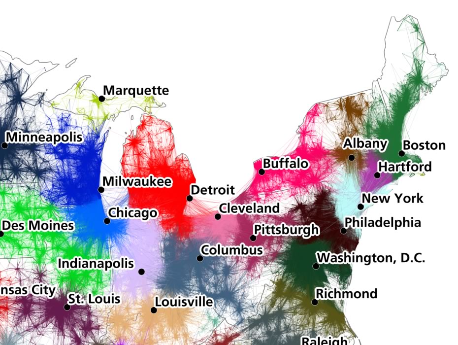
The Capital Region's relationship to the rest of Upstate
Another thing that sticks out in the various maps is how the Albany metro sort of stands apart from the rest of Upstate. And in some interpretations, it's more closely linked with Western Massachusetts and Vermont than, say, Syracuse.
We've always thought that Albany was somehow different from Syracuse, Rochester, and Buffalo -- that Albany leaned more toward New York City and the East Coast, while those other cities seemed more like they belonged to the Great Lakes. Maybe there really is something to that.
If anything, it's a reminder that "Upstate" is a big place and it's probably wise to not make generalizations about what sort of place Upstate is or is not.
Vermont
You know, Vermont was once part of (colonial) New York. Maybe it sort of still kind of is. (Don't tell Vermont that.) Or maybe Albany and eastern New York are still sort of part of Vermont. (Don't tell Albany that.) Maybe the Capital Region and Burlington need to talk more.
Also: This apparent connection between this part of New York and Vermont reminded us of the data from a recent NYS Attorney General's report indicating Vermont was one of the hot spots from which "likely trafficked" guns came to the Capital Region.
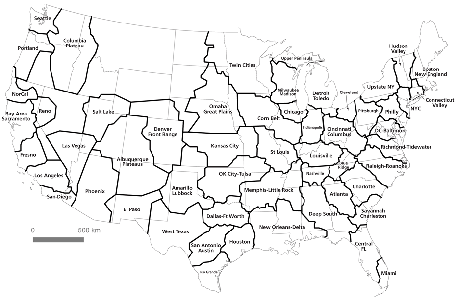
High-speed rail
One other quick thought: There's long been talk of maybe, potentially, someday running high-speed rail along a path that more or less follows I-90, so that it would connect NYC, Albany, Syracuse, Rochester, and Buffalo.
Complications and cost -- of which there are many -- aside, the Albany-New York City link seems obvious. That route is already highly traveled on the existing rail line. And this analysis of connections does't seem to provide any argument against it.
But... What about Albany to Buffalo? It makes sense when you look at a traditional map, but maybe it makes less sense when considering connections among those major cities. That said, if you could hop a train in Syracuse and be in Albany in less than an hour, maybe more connections start to form.
Say Something!
We'd really like you to take part in the conversation here at All Over Albany. But we do have a few rules here. Don't worry, they're easy. The first: be kind. The second: treat everyone else with the same respect you'd like to see in return. Cool? Great, post away. Comments are moderated so it might take a little while for your comment to show up. Thanks for being patient.
Comments
You ask about - what is the "Capital Region"? In 1982, I created and published a magazine named "Capital Region Life" . This was before anyone was even talking about a "Capital Region" and in it I defined what the "Capital Region" consisted of and devoted my stories to all of it. If you would like a copy, send me an e.mail I will mail you one (I published 6 editions - then got married to a man who was not interested in it - so, I put it on hold and so far, have never returned to it)
I believe it has on the introductory page the best definition of the Capital Region that exists - and does the most to tie it all together and promote the "region" as a whole. I hope you are interested. Let me know. DLH
... said Debora Liddle on Dec 6, 2016 at 2:17 PM | link
Confirms the theory that all of New Jersey is either a NYC or Philadelphia suburb.
... said Jackers on Dec 6, 2016 at 2:22 PM | link
For a lack of better terms (but slightly better than the broad brush of 'Upstate'), I have always called the Albany region the 'Middle East' of NY
... said James at 46 or so on Dec 6, 2016 at 2:31 PM | link
I grew up in the Utica area and moved out here in 1998. It really is funny how different the cultures are less than 100 miles away.
It's more laid back in the Utica/Syracuse area, and the culture is much more "country" whereas Albany and a lot of the are around it is much more fast paced and has more of a NYC influence. Both are nice places to live, but definitely different vibes.
At SUNY Albany I used to have countless arguments with one of my Long Island roommates about "Upstate" ... he would say "I'm not from Upstate like Paul" (who was from Suffern) and I would scream back "That's not upstate, Paul lives 5 minutes north of Jersey!!!". All about your perspective I guess.
... said Jeff W on Dec 6, 2016 at 3:22 PM | link
The regional designation map includes Sullivan, Ulster, Dutchess, Orange, Putnam, Rockland, and Westchester counties (as well as Nassau and Suffolk counties, of course) as part of the NYC metro-area.
Does this add any clarity to what constitutes "Upstate" verses "Downstate" geographically?
... said Bob on Dec 7, 2016 at 9:06 AM | link
>>Or maybe Albany and eastern New York are still sort of part of Vermont. (Don't tell Albany that.) >>
I dunno ... there are a lot of us that wouldn't mind being lumped in with VT! :) (If only it was as quirky and the beer was as good ... but, at least on the latter point, we are getting there pretty quickly!)
... said JOTeepe on Dec 7, 2016 at 10:30 AM | link
>>>Or maybe Albany and eastern New York are still sort of part of Vermont. (Don't tell Albany that.)
At this moment I don't even mind being lumped in with Canada. At least for the next 4 years
... said Lu on Dec 7, 2016 at 11:02 PM | link
"I dunno ... there are a lot of us that wouldn't mind being lumped in with VT!"
I escaped Vermont. Please don't make me part of it again.
... said JayK on Dec 8, 2016 at 12:44 PM | link
Upstate is anything north of I90 and/or west of I88. :)
Interesting map. I don't know anyone who would agree with the label of 'Hudson Valley'.
... said komradebob on Dec 8, 2016 at 3:35 PM | link
How about we start with a normal train line connecting Albany and Boston...
... said Duh on Dec 27, 2016 at 12:12 PM | link