
A few bits about the proposed Albany Skyway
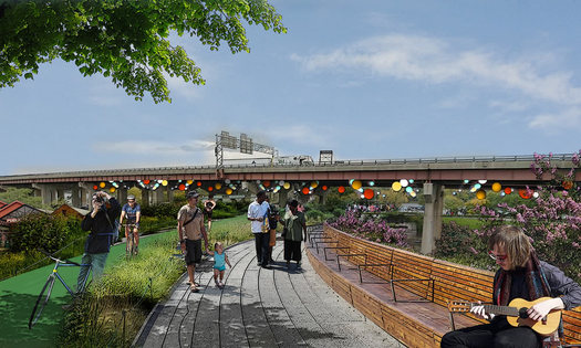
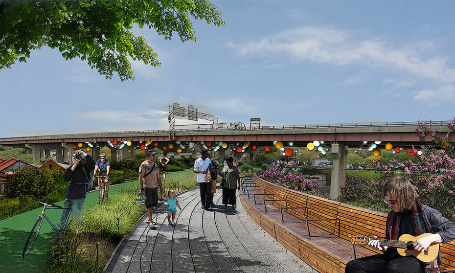
A rendering of the proposed park.
Updated with comment from NYSDOT.
One of the more intriguing Capital Region projects to pop up in the state's Regional Economic Development Council funding announcements this week is a linear park that would take over an off-ramp that connects currently connects Quay Street along the Albany riverfront to Clinton Ave downtown.
Here are a few details about the "Albany Skyway"...
Project description
From the REDC briefing book:
Capitalize Albany Corporation will conduct planning and feasibility studies that will ultimately result in conversion of the northbound exit ramp from I-787 from Quay Street to Clinton Avenue to the region's first and only highline park. Upon conversion, the former ramp will serve as a promenade, bike route, and linear park making valuable connections, dramatically increasing accessibility to both downtown and waterfront."
Capitalize Albany was awarded $375,000 for the studies.
This idea sounds vaguely familiar...
This isn't the first time the project has come up -- it was tucked into the Impact Downtown Albany "playbook" released in 2015. We have to admit, at the time, it sounded like a long shot. The funding for a planning and feasibility study moves it closer to actually happening.
Why this project?
Sarah Reginelli -- the president of Capitalize Albany, the economic development arm of the city of Albany -- said Friday the idea grew out of the realization that the traffic numbers for this off ramp are very low -- so much so that ramp is essentially redundant. (There's still a way to exit via Quay Street.)
So then the question became: How can this piece of infrastructure be reused?
Reginelli said the success of similar projects in other cities -- most notably the High Line in Manhattan -- got planners thinking about a park. And that idea happened to line up with a lot of other goals the city and Capitalize Albany have been pursuing, including taking back parts of 787 and building better connections across the highway to the riverfront; increasing pedestrian and bike amenities; and helping to reduce storm water runoff.
The ramp is also located at the northern end of downtown, so it can provide a riverfront connection not only for downtown, but also Arbor Hill and the developing Warehouse District just to the north.
"It hits every priority that people have been looking for in downtown revitalization," Reginelli said.
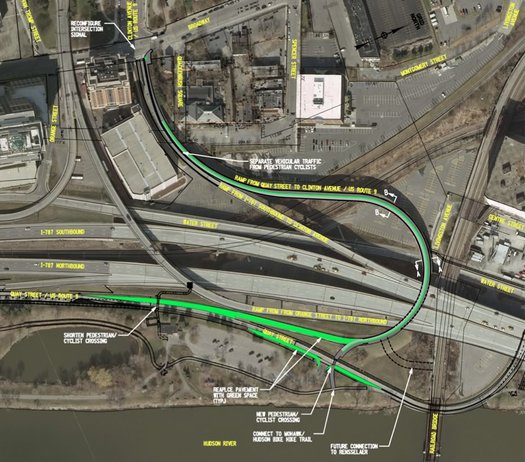
There's a larger version of this diagram above in large format -- click or scroll all the way up.
How much is this going to cost?
There's not a solid projection of the cost of converting the ramp to a park yet -- that will be one of the goals of the feasibility study.
Reginelli said Capitalize Albany got two earlier, very rough estimates from engineering firms that a basic conversion -- with pedestrian and bike amenities -- would probably cost about $5 million. A more extensive conversion -- with lots of added greenery and other features -- would be more like $12 million.
But Reginelli said the project doesn't necessarily have to be done all at one time. It could be completed in phases if the full funding isn't available at the beginning.
"This isn't something that we want to start designing and have sit on the shelf," Reginelli said.
Toward that end, she said the city has already been working on finding funding for the project.
What's next?
Reginelli said Capitalize Albany will be issuing a request for proposals for the planning and feasibility study. The results of that will guide the next steps.
There's also the issue of working with the New York State. The ramp is owned by the state, and Reginelli said they're looking forward to working with the state Department of Transportation on every step.
Update: From Bryan Viggiani, the Capital Region public information officer for the state Department of Transportation:
DOT supports this concept, which would provide a new, vital link between downtown Albany and surrounding neighborhoods with the Hudson River and its cultural and natural resources. We look forward to working with the City of Albany on this innovative and transformative project.
Hi there. Comments have been closed for this item. Still have something to say? Contact us.
Comments
The High Line in NYC is great. It brings a wonderful pedestrian green-space into areas that lack it. Unlike the High Line, this proposes creates green-space right next to existing green-space, the Corning Preserve. Additionally, the city already created a bridge over 787 to Jennings Landing for pedestrians and cyclists. The city has allowed the landscaping at Jenning Landing to become nothing but overgrown shrubbery and weeds. You can expect the same neglect for this new space. In my opinion this money could be better spent elsewhere.
... said Spencer on Dec 10, 2016 at 9:23 AM | link
Spend the money on something else maybe like a new high school more trade schools n more jobs.
... said Saycheeze on Dec 10, 2016 at 11:38 AM | link
Not to be a naysayer, but . . . I have to agree with Spencer. What makes the High Line in Manhattan great is its excellent design and landscaping, the variety of interesting spaces created within the confines of the elevated track, commitments to continue to fund its maintenance and security, and the intimate views onto an urban neighborhood it offers pedestrians. The High Line has spurred so much residential building that in many places pedestrians can now peer right into new condos at eye level or look up at them. The elevated track is integrated into the urban fabric of the city. If one can't realistically achieve any of these things in Albany, there is no point to modeling a new project on the High Line. Come up with a new idea. Or, better, if the ramp isn't needed, remove it! There is far too much elevated highway-ramp structure in Albany. Let people get to the riverfront and Corning Preserve as directly as possible (not by a circuitous route), and make them a destination people want to get to.
... said Peter on Dec 10, 2016 at 12:29 PM | link
A project like this is the "fluff" you put on at the end. It's a nice concept but first the city has to develop around it not vice versa. Let's start out with something pretty basic like a bookstore or a movie theater or a men's store or a women's clothing store, or a library, or _________(enter just about anything).
... said BS on Dec 10, 2016 at 3:03 PM | link
I was curious about the actual path, so thanks. The article on another news outlet described it as a "little-used" ramp, which confused me. I used to use this ramp 2-4 times a day when I lived there, so it's hard to picture it as little used. Don't care one way or the other but it would sure be nice to see that effort and money put into getting the path to cross at the Livingston Avenue Bridge.
... said Carl on Dec 10, 2016 at 4:22 PM | link
What I'm missing here is where is the demand for such a thing? And why would anybody on foot take such a roundabout way to get to park that already has direct access via a very expensive bridge over 787 built specifically for that purpose? Comparing this to the High Line, that's just wishful thinking here. Also, it's still a bridge that will need to be maintained by DOT at the same cost as it takes now, plus the maintenance of the 'green space' which Albany isn't exactly stellar about these days.
Want to improve Albany? Being some retail to downtown, not just the typical transient restaurants and pubs that come and go every few years. Albany needs more commerce, and a few less intoxicated 20-somethings wandering about N. Pearl St. & Broadway on Saturday nights.
... said Captain Geritol on Dec 10, 2016 at 4:45 PM | link
I live on North Swan Street just off Clinton and I and my neighbors use this Clinton Ave exit from North 787 all the time. Once again it's hipsters over the 'hood. The Quay street route is lame. The Albany High Line? Laughable fantasy. Have you ever been down there? Keep fixng up the Preserve and the Landing, they are getting close.
... said james lanni on Dec 10, 2016 at 8:34 PM | link
BS, cities aren't supposed to build businesses like bookstores.
Still, it's important to ask, what would the real return on investment be for this project? If it will attract private investment in businesses that will generate more revenue than the project will cost, sure, go ahead. If not, then it's just a nifty thing that raises taxes, and the money should be used on another project that will pay for itself.
On the other hand, if we want the Mohawk Hudson Trail and the Rail Trail to be more than just long skinny parks, they need to be connected to places people want to ride to and from. This could be an important link into the city.
... said Zed Fechten on Dec 10, 2016 at 9:07 PM | link
Whatever happened to the idea of having a waterfront along Broadway?
... said alan on Dec 11, 2016 at 4:40 PM | link
It's December. There will probably be 20 people pass through the area where this project is proposed between now and April, Unlike the High Line, the proposed pathways don't connect anything at least during the months of darkness here in the near arctic.
That said, the most interesting thing about the proposal is the vague future connection to Rensselaer. Make that an actuality by funding it and you'd have something interesting that would drive traffic way up especially for cyclists. The other option for cyclists for getting across the river, the Dunn Bridge, is about as "unfriendly" as it gets and almost impossible to remediate.
... said Frank Kelly on Dec 11, 2016 at 5:18 PM | link
This is very infrastructure that you put in so you get the clothing store, cafes, indie bookstores, etc. Easy quality of life things that attract young people who pay taxes and spend money.
Shout-out the mandolin player.
... said Dan on Dec 11, 2016 at 5:20 PM | link
Related aside: I read books. I love books. I occasionally buy books. (I'm more of a library user). There's no bigger fan of books than this girl. But I'm baffled by people always suggesting the need for book stores when a development opportunity arises. Major chains can't compete with Amazon (RIP Borders and B.Dalton, among others) and the independent bookstores are hanging by their fingernails. Despite our deep affection for them, I respectfully submit that small bookstores are not quite the sustainable business model/destination that will lure crowds of people.
... said Rebecca on Dec 12, 2016 at 8:14 AM | link
I'm sorry but this is dumb. The concept is fine but as noted above, it's a very indirect, maintenance would still be an issue, and the jennings landing bridge is a quarter mile away. A connection to livingston ave would be much more useful. Maybe if the livingston ave bridge is ever tackled, parts of this could be attached to that project. But on its own it seems pretty pointless.
... said Ed on Dec 12, 2016 at 9:20 AM | link
Just take it down if it is redundant. The less concrete separating downtown Albany from the Hudson the better. Access is better achieved at ground level and as mentioned by others, continued maintenance is never considered in these type of municipal projects.
... said ace on Dec 12, 2016 at 10:14 AM | link
"Still, it's important to ask, what would the real return on investment be for this project?"
That's easy. It is just in time for Sheehan's re-election campaign. This project will sound good to lots of people who never go into this neighborhood, but who vote.
Remember where we are.....this is Albany.
... said Stan on Dec 12, 2016 at 10:53 AM | link
I love the High Line but agree with the comments above that an elevated park is not right for this spot. It's basically above an existing park and the extra connection doesn't seem necessary when the park is already accessible by foot at the landing and by car at Quay St.
The riverfront park has seen huge improvements this year - put the millions that would be spent on this project toward finishing the connection between the park and the Helderberg Rail Trail. Orrr getting the Livingston Bridge suitable for pedestrians and bikes (or put it into the Gondola fund :)
... said Paul on Dec 12, 2016 at 12:32 PM | link
PS to those who babbled on endlessly about a bookstore......it's NOT about the books......
... said BS on Dec 12, 2016 at 1:58 PM | link
Some peopke need to get out more:
https://www.northshire.com/saratoga-springs-store
... said Frank on Dec 12, 2016 at 9:45 PM | link
Albany has been aggressively pursuing access to the waterfront since Corning's time - that's 3 decades for folks counting. The Albany 2020 plan and efforts to study 787 and a potential staring point for it's removal or downsizing started a decade ago.
A downtown is only as good as the amenities it offers. Cities across the US, large and small, that have invested in waterfront amenities have seen a surge in downtown investment. Baltimore, Indianapolis, Providence, Minneapolis, Denver.
Let's also consider that the average daily traffic on this ramp is so low that NYSDOT is considering abandoning it. Consider that, the state is considering jettisoning infrastructure that doesn't get enough traffic to warrant continued maintenance. So what would here? See Buffalo's Niagara Scenic Parkway for a historic perspective.
With demand increasing for waterfront connection and the possibility of NYSDOT abandoning the ramp, this is a wonderful opportunity to look at.
School and transportation funds come from very different sources. The city and state cannot take transportation dollars and build a school with it, or a movie theater for that matter. It doesn't work like that.
I appreciate the shot out for the Livingston Ave Bridge, so let's put that in perspective too. How would one access the bridge? By a ramp, of course. But where would the ramp be located? Why, this structure is at grade of the railroad! This would make the PERFECT access for a rebuilt bridge! Now, the source of funds for the multi-million dollar RR bridge reconstruction, if Congress ever appropriates high speed rail money, would be federal, and years out (I'm going to guess it will be January 2020 before we can even think of real transportation investment) but that doesn't mean this idea has to be put on ice.
Kudos to Capitalize Albany for taking on the venture. It's really encouraging that the economic development non-profit is stepping forward and helping the City meet the goals we developed in our Comprehensive Plan. Want to make a 24-hour downtown? Need to create linkages to amenities that make people want to live and visit downtown.
... said daleyplanit on Dec 14, 2016 at 9:09 PM | link
I am just going to offer a prediction here:
a) This plan will be touted between now and November 2017
b) Sheehan is re-elected
c) ......crickets.......
... said Stan on Dec 15, 2016 at 10:59 AM | link
Thank you, daleyplanit, for this perspective. We can sit around endlessly complaining that there isn't enough that is already going on this area, or we can do whatever we can to make it happen. This project is part of the latter.
And let's not forget that this small area is rapidly improving. We already have great, well-established businesses such as the Pump Station, McGeary's, Olde English and now a creperie (with excellent food!). Beyond that, the Palace is planning an expansion and two new apartment buildings are going in roughly a block away.
There are real concerns with this idea that deserve discussion, such as the cost difference between the two versions, the quality of the final project based on that cost difference, the long looping path to the water (that as was just pointed out, could actually be a benefit leading to more connections) and necessary cooperation with the state to get anything done. Let's not distract ourselves with irrelevant concerns like bookstores or inane suggestions like spending far more to remove the ramp only to be left with a remaining highway barrier and no cool park.
... said JayK on Dec 15, 2016 at 11:14 AM | link
A few thoughts…
Albany…is…not…NYC: We tend to be negative Ned and Nancies’ about such opportunities, because how possibly could folks in our region gravitate to such concepts like they do in NYC. In my book, this will always be an apples to oranges comparison, and such thinking continues to pull this region down from what it could really be. Just look a bit south of us, and this same negative group think dominated talk in Poughkeepsie when they sought to convert a decommissioned bridge into a walkway over the Hudson. “Who the hell would want to see the smelly Hudson and terminate such a trip in the armpit of Poughkeepsie!!†Well, expectations have been shattered over the recently installed Walkway Over the Hudson, it’s become a regional gem that draws visitors from the broader NYC metro region, and business downtown in Poughkeepsie and the Town of Highland (on the Western side of the Walkway) are enjoying the increased foot traffic, along with the growing number of events associating themselves around the Walkway. Again, I think this plays into the notion that if Albany does “X†it can’t possibly see “Y†results like in NYC. Reminder NYC/Greater Metro = 8 million/20million; Albany/Albany Metro = 100k/900k. These don’t even factor in tourists (yes, the Capital Region does benefit from a healthy number of them). End of the day, the scale will never balance, so let’s stop comparing and enjoy the fruits of our own labor.
Albany…is…not…NYC (Part II): Maybe I’m overly optimistic, maybe I’m just plain blind and stupid, but I see good things emerging downtown. More specifically, in the past three years, I’ve witnessed a pretty healthy uptick in foot traffic in the evening and on the weekends. I often take the bus from uptown to downtown and am pleasantly happy to see folks downtown enjoying Cider Belly, The French Press, etc. On a recent 30 degree Saturday morning, Old English’s outdoor patio was filled up, preventing me from stopping by with my dogs after a walk along the water front (where, mind you, I saw a good 20+ people in the 15 minutes I was out there). I don’t see the crushing pedestrian masses piling into Times Square, but things seem on pare with any one of the residential neighborhoods you may see in NYC like Tudor City or Upper West Side, with a healthy dose of casual foot traffic. End of day, stop complaining, get out there, take advantage of what downtown has to offer and love it.
What comes first, the chicken or the egg: Neither, let’s crack that darn egg, dispense with waiting for that chicken to come, and stop shooting down projects and ideas because perception says that the book store should come before the walking trail, which needs to come before the gondola, which needs to come before we build that rocket pad to Mars…I think you get it. Urban planning doesn’t always need to be sequential. I think the Skyway in the short term ties into a lot of good things happening downtown and is a forward thinking piece of the broader ecosystem being fostered between downtown south and the bubbling downtown north (read as the Warehouse District), and the waterfront more broadly. I’d love to see the day when we have the Jennings Walkway, the Skyway, the South-End Bike Trail access way, and my own fancy idea of a tunnel under or walkway over 787 from Huck Finn’s Playland to the Corning Park, allowing several opportunities to cross between downtown and the waterfront.
The Skyway to Nothing: I total disagree that this is in an awkward location with no value. Totally ignoring all the residential units that will be coming online around this section of North Pearl (and a few blocks up, the Sheridan Hollow evolution via Habitat for Humanity and other stakeholders), which will add to growing number of residents in the immediate neighborhood, this walkway will start or terminate (depending where you start) at Quackenbush Square, feeding into existing business (Pump Station, Old English, Albany Distillery, Visitors Center, etc) and hopefully future opportunities, specifically when the reminder of Quackenbush Square gets developed. Plus, you are 10 minute walk or 2 minute bus ride from the Warehouse District. Furthermore, I think this will be a far more pleasant (and direct) walk for all those state workers who have to walk the boring, claustrophobic “Walkway†along Water Street. Again, more points of access to the waterfront and downtown is the way to go in order to ensure everyone can enjoy this asset and that businesses can weave around these points of egress/ingress.
But…but…but: The roads are crumbling, the sewers are exploding, there’s no preparation efforts for the impending Zombie Apocalypse. Yes, all true, but infrastructure management is as old as the concept of cities themselves. We will always have these issues, and I’ll be first to admit that we sometimes don’t take good stock of all our resources and stakeholders and how best to leverage them appropriately to address all those needs on our “to-do list.†However, the funding going towards the design study is state money, wrapped up in a lot of Cuomo top-down-I-know-better-than-thou-ness, so we need to play the game in order to up our game. State DOT is pretty darn serious about divesting in this infrastructure, which means the City of Albany would be on the hook to maintain (and most likely, provide expensive TLC to the ramps, like all the other ramps along 787 are receiving in various fiscal years), meaning we’d have to foot a good $2-4 million (at least) to keep this in place. I could be wrong, but converting to a pedestrian pathway is probably a cheaper long-term proposition.
... said Rich on Dec 16, 2016 at 8:09 AM | link