Mapping out a future for bikes in Troy

What's the route to follow to make Troy more bike and pedestrian friendly?
That's the question at the heart of the current push to create the Troy Bike Connections Plan. The backers of the project -- which include the city of Troy, the Capital District Transportation Committee, and Parks & Trails New York -- released a draft of the plan at a public meeting Wednesday evening.
And the materials are now online, if you'd like to have a look.
"There are a lot of streets in Troy that can be transformed with not a ton of engineering to become more bike friendly," said CDTC's Jennifer Ceponis Thursday, emphasizing the plan is a way of mapping out a direction for future projects as money and opportunity present themselves. "This is going to be incremental, for sure."
A few things about the proposed plan...
Three types of streets
The plan lays out a network of possible bike-friendly streets identified by Parks and Trails NY according to three categories:
Primary bikeways
These are higher traffic streets such as Burdett Ave, Congress Street, Federal Street, and 2nd Ave. These would be candidates for some robust bike lanes options such as cycle tracks (which some sort of barrier to separate a bike lane from car traffic), buffered bike lanes (a regular bike lane with striped buffer zone separating it from the vehicle lane), and striped bike lanes.
Secondary bikeways
These are medium traffic streets such as 4th Street, Campbell Ave, and Oakwood Ave. They'd be candidates for amenities such as striped bike lanes, "contra-flow" bike lanes (which allow cyclists to ride in the opposite direction of vehicular traffic), a new higher-visibility markings at intersections.
Neighborhood bikeways
As the name suggests, these are relatively low-traffic streets within neighborhoods. Street treatments could be focused on calming vehicle traffic via things like speed tables and small neighborhood traffic circles and curb extensions.
There's map at the top of the proposed bike routes and categories -- click or scroll all the way up.
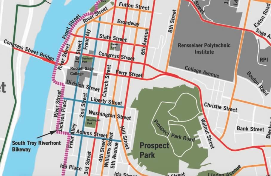
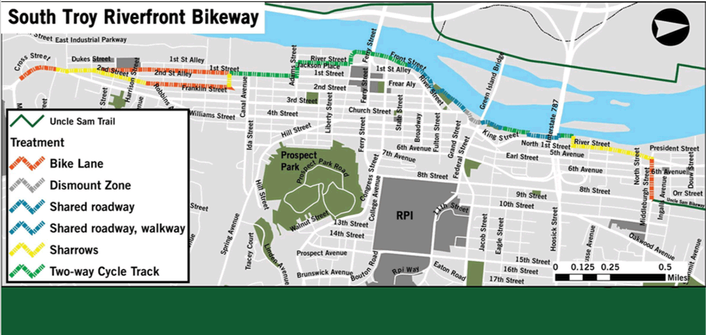
South Troy Riverfront Bikeway
Part of the plan includes a project that's already been rolling along: the South Troy Riverfront Bikeway -- which is pretty much what it sounds like. It would create a bike corridor stretching from South Troy up to the Uncle Same Bikeway north of Hoosick Street.
The city of Troy is planning to move forward with the project in 2018.
Among the notable aspects of the plan: A two-way cycle track -- that is, a separated bike lane -- that cover about a third of the route. If that ends up being built, it would be the first such bike lane in this region.
Issues up for discussion, and feedback
Among the topics CDTC's Jennifer Ceponis said came up Wednesday evening and planners are thinking about:
+ How best to deal with east-west connections that travel up the hillside in Troy. Ceponis said there's some thought that maybe there could routes that zig zag up the hill so it's not so hard a climb.
+ Ways in which bike infrastructure might also help people with disabilities.
+ More awareness and connections for the Uncle Same Bikeway, which despite its location in the heart of the city, has relatively low levels of use compared to other trails.
Ceponis said planners are looking for feedback -- and a form on the project website if you'd like to offer some ideas. She said the final plan is expected be ready in early 2018.
Hi there. Comments have been closed for this item. Still have something to say? Contact us.

Comments
How can you call something a "primary bikeway" if there are signs saying you cannot ride your bike on it? The Troy-Menands bridge has large signs saying that "cyclists must walk". In fact, from Mill Street to the other side of the bridge, according to the signage, bicycles are not supposed to be ridden. That's something like 3/4 mile. Yet that's a "primary bikeway"?
... said Blergh on Nov 28, 2017 at 11:34 AM | link