Some number of facts about the Normanskill
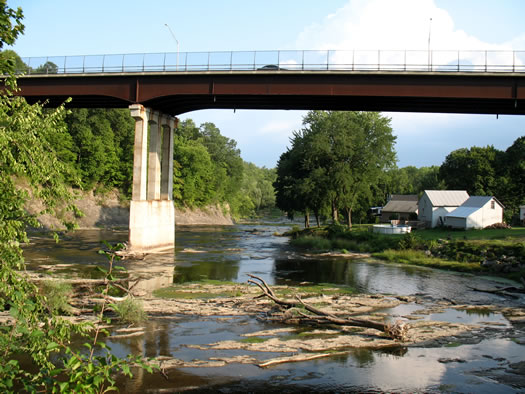
It's a long running thread through this area.
With the Normanskill in the news this week, we thought it'd be interesting to look into the stream's course through this area -- both in geography and history. We started with the intent of digging up one fact or bit for each mile of the Normanskill -- but, frankly, we lost count.
So here is an undetermined number of facts or bits about the Normanskill.
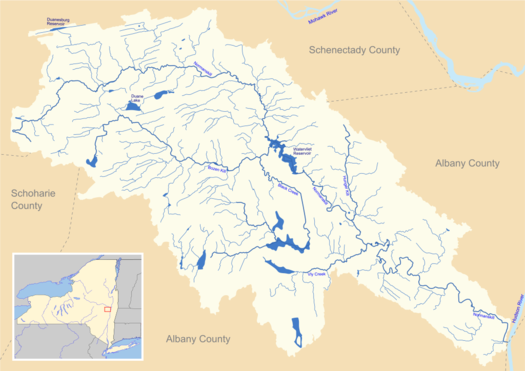
The Normanskill watershed. / map: Wikipedia user ZooFari (CC BY-SA 3.0)
+ 45.4 miles long.
+ It drains an area of more than 170 square miles.
+ It starts in Gallupville on the western edge of Schenectady County, and then winds its way through Delanson, Duanesburg, Princetown, Rotterdam, Guilderland, New Scotland, Bethelehm, and then along the Albany/Bethlehem border, and then a little more Bethlehem before emptying into the Hudson River.
+ Along the way it feeds the Watervliet Reservoir.
+ The Watervliet Reservoir is not in Watervliet, but in Guilderland. (You've probably caught a glimpse of it from Western Turnpike/Route 20.) It's owned by the city of Watervliet, and provides drinking water to Watervliet and Guilderland.
+ The reservoir was created in 1915 by damming the Normanskill. In the 1980s a small hydroelectric facility was incorporated into the reservoir to generate electricity to run pumps.

A map from 1893. [via]
+ The Normanskill empties in the Hudson River just south of the Port of Albany in Bethlehem, an area that's been shaped considerably by humans over the years. The piece of land is flows past there is called Cabbage Island -- though it's not an island any longer. A marshy collection of islands has been filled in over the years there. Among the islands: Castle Island, which is thought to be the location of the earliest European forts in the area.
+ There's archaeological evidence that Native Americans once had small camps and one or two small villages in areas along the Normanskill in Albany County.
+ Among the Native American names for the Normanskill: Tawasentha, which is an Iroquois word. (This name still shows up in a few places, including as the name of a park in Guilderland.)
+ Tawasentha (and the area along the Normanskill) makes an appearance in Henry Wadsworth Longfellow's "The Song of Hiawatha".
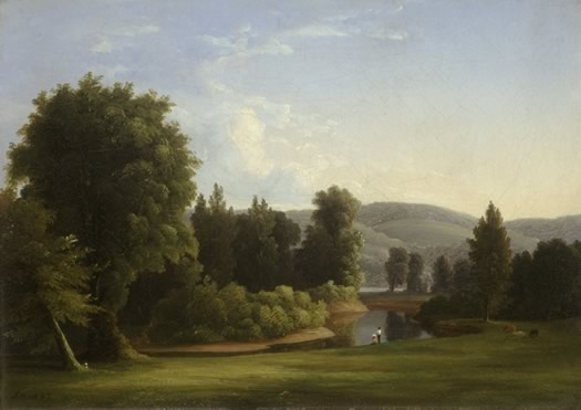
"View of the Normanskill, near Albany, New York" by James M. Hart, circa 1850, from the collection of the Albany Institute of History and Art.
+ The Normanskill also served as a subject for Hudson River School painter James McDougal Hart, who grew up in Albany.
+ The name "Normanskill" is, like many stream names in this area, from Dutch. "Kill" means creek or water course. The "Norman" refers to Norway, specifically a person from Norway.
+ That person was Albert Andriessen Bradt, one of the first non-Dutch Europeans to settle in the Rensselaerswyck colonial estate. He came here in 1637. From a post on AOA that Carl Johnson wrote a few years back:
Albert Andriessen Bradt held the water rights for the creek that emptied into the Hudson south of Beverwyck and Fort Orange. He operated what was probably the first sawmill in the area, as well as trying to grow tobacco for the patroon. The creek that powered it came to be known as the Norwegian's Creek, or, in Dutch, Normans Kill.
+ One of Bradt's children, born during the crossing of the Atlantic, had one of the all-time great names in Albany history: Storm Vanderzee -- "storm from the sea."
+ Bradt's descendants -- both Bradts and Vanderzees -- participated in the founding of both Albany and Schenectady. And there are members of the family still here today.
+ The portion of the Normanskill near where Delaware Ave crosses it today has been the site of multiple mills and other operations over the years. There was even an ice house at one point.
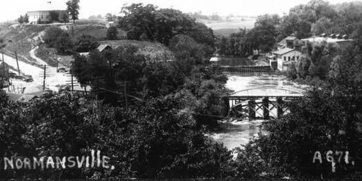
Normansville, circa 1900. The building on the right is an ice house. / photo via Wikipedia
+ That area between Albany and Betlehem, on both sides of the Normanskill, at the Delaware Ave crossing is called Normansville. It was once totally in Bethlehem until Albany annexed the land up to the stream.
+ There have been a series of bridges at this spot. One of the old bridges, part of the old Delaware Turnpike -- still remains, though it's closed to vehicle traffic. It's known as "Yellow Brick Road" because of the pavers used on it. (There's an old story, very unconfirmed, involving Edgar Allan Poe, a letter, and L. Frank Baum, the author of The Wizard of Oz. )
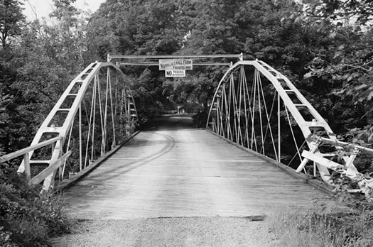
The Whipple Bridge, probably sometime in the late 1960s. / photo: Historic American Engineering Record via LOC
+ Another old bridge from the area -- the Whipple Cast and Wrought Iron Bowstring Truss Bridge, which dates back to 1867 -- also still exists, though it's not in its original location. It's one of the oldest remaining bridges of its type.
+ In the late 1920s a viaduct was built to carry Delaware Ave above (and past) Normansville and the Normanskill. And in the 1990s a new bridge -- the current bridge -- was built.
+ The landslide this week wasn't the first along the Normanskill in recent memory. In May of 2000 a landslide on the Bethlehem side opposite the Normanskill Farm property in Albany closed a portion of Delaware Ave for three months -- and Normanskill was re-routed. And in 1968 there was a 15-acre landslide farther up in the Normanskill in Slingerlands that blocked the creek and prompted flooding. A 2007 Albany County report stated that "erosion and landslides appear to be persistent problems along the Normans Kill, particularly where there is stream-side development and/or significant clearing of slopes."
+ Another issue that's gotten attention in recent years: water quality. The point at which the Normanskill empties into the Hudson River has often tested above acceptable limits for sewage-indicating bacteria levels, according to Riverkeeper. (Here's Riverkeeper's page compiling test results.) The problem: "combined sewer overflows," in which storm water ends being mixed with sewage during heavy rain events.
+ Today a large portion of the area along the Normanskill in the Normansville area is open to the public thanks to the city of Albany's Normanskill Farm. The land includes trails along the stream, a dog park, a community garden, and training facilities for Albany police. The land also connects with the city's Capital Hills golf course property. Some of the land on the south side of the stream at that spot is also open to the public as part of the Mohawk Hudson Land Conservancy's Normans Kill Preserves.
Hi there. Comments have been closed for this item. Still have something to say? Contact us.
Comments
So interesting! Thanks!
... said LC on Apr 23, 2015 at 3:09 PM | link
Thanks for the flashback; I'd completely forgotten we'd covered that way back when. I can just say that my kids are VERY pleased that I found out they were descended from the Norman AFTER they were already named, because otherwise there'd be a Storm Vanderzee Johnson running around the halls of higher ed today.
... said Carl on Apr 23, 2015 at 5:18 PM | link
"The 'Norman' refers to a Norway, specifically a person from from Norway."
Normandy, not Norway.
... said Blergh on Apr 24, 2015 at 1:17 PM | link
@Blergh: In most cases, Norman does refer to Normandy. But not in this one.
Albert Andriessen Bradt was originally from Norway, by way of Amsterdam.
In Dutch, the word for Norway is Noorwegen. So, a person from Norway: Noorman. His stream: Noormanskill. Anglicize it a bit: Normanskill.
(Thank you for highlighting the typo in that sentence -- it's been fixed.)
... said Greg on Apr 24, 2015 at 1:56 PM | link
This is very cool stuff, I grew up in Slingerlands and am from the Bradt line. I live in the British Virgin Islands where we have Norman Island (Hence) Very Old for Norweegan.
... said Douglas Perry on Apr 27, 2015 at 10:16 PM | link
Very happy to have seen this post. Wonderful bit of local History. Thanks to the Author. MOH
... said Mike OHeaney on Jun 16, 2015 at 4:11 PM | link
The Normanskill starts near Gallupville Road in Schenecetady County. Gallupville is in Schoharie County.
... said john on Jul 29, 2015 at 9:32 PM | link
Are there records of drowning's over the years in the Normanskill? My father''s brother drowned in the Normanskill when he was 5 years old in the early 1940s in Albany and I was hoping to find information about the event.
... said Peter on Sep 17, 2017 at 12:09 AM | link
@Peter
Your best option would be to search a newspaper database like this one (it's free and, while the search options are a little quirky and take some getting used to, it's a treasure with millions of pages of newspapers).
http://www.fultonhistory.com/Fulton.html
It's very possible the newspaper would have mentioned such a drowning.
... said Paula on Sep 17, 2017 at 2:26 PM | link
I live along the creek wondering if there is any aid or help for replanting. In order to help keep the erosion in check .Erosion during heavy rain is a large reason these slides are going on .Yes the landslide in Delmar behind Normanside golf course was due to the dumping of materials where there should not have. The slide behind the fruit stand on Delaware Ave was erosion. I feel it was caused by the very sharp turn of the creek just below the fruit stand .Also the clearing of the power lines did not help ,less rooted plants and trees at that steep of an incline .The slide at Maher road in Slingerlands was do to the allowance of materials being dumped on the property where the slide Occurred .But not engineered in properly
... said Tony on Apr 15, 2018 at 7:51 PM | link
Tony, there is a program for landowners to plant trees and shrubs along tributaries to the Hudson River, including the Normanskill. It's called Trees for Tribs and run by NYS DEC's Hudson River Estuary Program.
https://dec.ny.gov/lands/43668.html
Also keep in mind that the areas thick, clay soils are prone to landslides, which should inform land use along the creek.
... said karen on Oct 28, 2018 at 12:42 PM | link