Options for the Madison Ave Road Diet
Could it stand to lose a lane or two?
Can Madison Avenue in Albany's Pine Hills neighborhood be a better version of itself, one that both moves cars along but also provides a safer, more comfortable experience for cyclists and pedestrians?
That's the question at the heart of the proposed Madison Ave Road Diet, one of the region's most interesting transportation projects -- and a high-priority focus for cycling advocates pushing for protected bike lanes. Wednesday night at the College of Saint Rose city officials and consultants unveiled the menu of proposed options for reconfiguring the thoroughfare.
"It's most important that we get it right," Albany mayor Kathy Sheehan told the crowd Wednesday in emphasizing the importance of public feedback on the project. "We're really going to have one opportunity and then this will become the model for what we do in other parts of the city."
Here's the menu of options, along with a few thoughts...
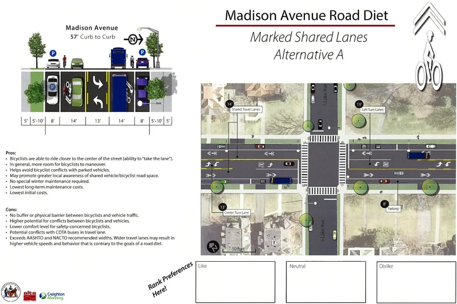
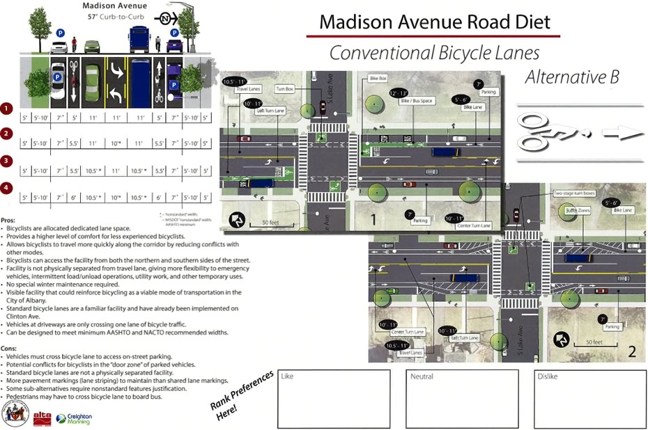
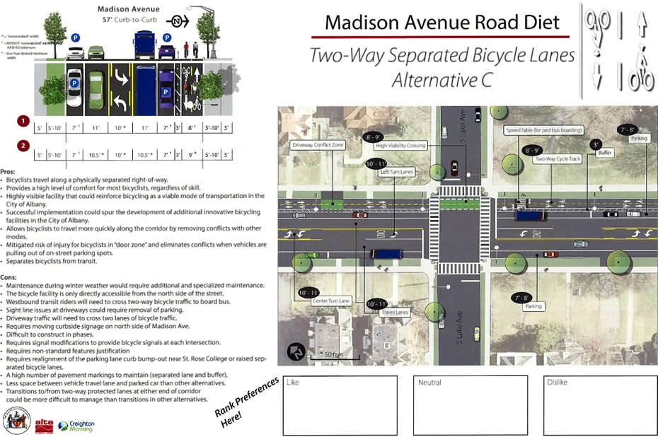
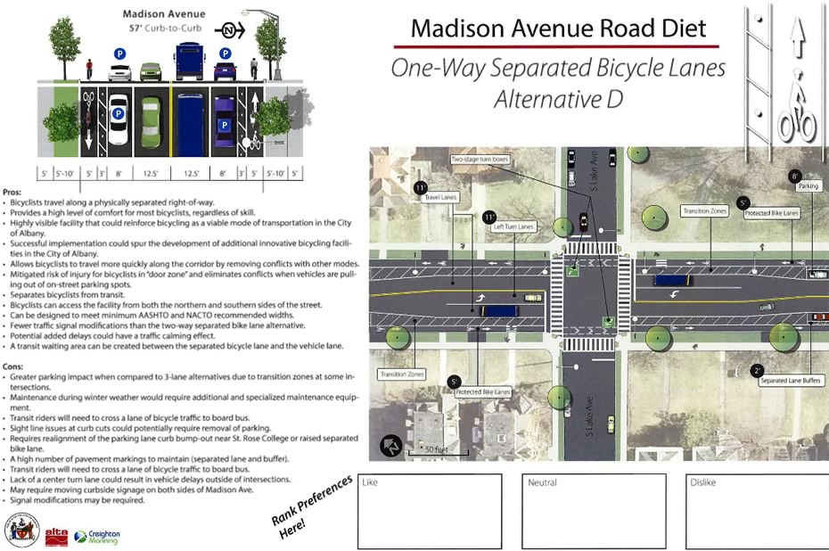
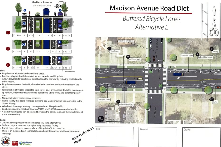
Proposed layouts
They're above in large format -- click or scroll all the way up to have a look.
A few thoughts
Bike lanes are a yes... generally
The presentation at Saint Rose involved poster boards at which people could express their preferences for options by placing a sticker on the board under "like," "neutral," and "dislike." Informally surveying the results near the end of the session, two things struck us about the apparent crowd preferences:
+ Pretty much no one preferred Alternative A, which didn't include dedicated bike lanes, and instead made us of "sharrows."
+ The other four options -- which include various types of bike lanes, both those demarcated by lines and those set aside by some sort of barrier -- all got strong support. And that support was spread across the four options.
The effect of better bike lanes could be relatively big
One of the questions about significantly increasing the amenities for bikes along Madison Ave is, essentially, whether it will make a difference in the number of people who cycle along the stretch. And one of hard parts of that question is figuring how many people would be riding there if they felt more comfortable.
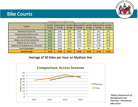
A slide from the public presentation.
Wednesday's public presentation included bits that point to some possible answers. Lindsay Zefting -- an engineer with Alta Planning + Design, one of the consultants working on the road diet for the city -- mentioned that previous counts indicated that Madison Ave averages about 30 cyclists per hour -- and some spots along it see more than 50 per hour. And if there were better bike amenities that would make less confident riders feel more comfortable? She said a group of studies reported on average a 90 percent increase in ridership for streets that went from no bike facilities to separated bike lanes.
There are going to be tradeoffs
Because there always are. Generally speaking, the tradeoffs involved are:
+ Space within the road: The first three alternatives include a third lane in the middle for turns. Of course that eats up width for travel lanes, parking, and bike lanes. Eliminating the middle turn lane opens up space -- it's roughly an additional 10-11 feet to work with -- but that also creates the potential for backups as vehicles wait to turn. It also might make it a bit more difficult for emergency vehicles to squeeze through.
+ Bike amenities: The more robust the amenities for bikes, the more space they tend to take up. The less robust the bike amenities, the less comfortable riding along the street will be for a wider range of cyclists.
+ Parking: Some of the bike lane options -- like the "buffered bike lane" option in Alternative D, would take up some space from parking.
+ Maintenance costs: The more complicated the bike amenities, the higher the potential costs of building and maintaining them. For example: simple striped off lane is going to be less expensive to build and maintain than a lane with vertical barriers. One potentially big maintenance issue: clearing snow. Mark Sargent from Creighton Manning, the engineering firm acting as the lead consultant on the project for the city, told the crowd Wednesday night that protected bike lanes could require new equipment to clear snow, and the plowing costs could be in the hundreds of thousands. But as Bill Trudeau, the city's coordinator of traffic engineering, added, the city could also just opt to let the snow pile up more frequently in bike lanes and clear it when it's more convenient. He framed it as situation in which the city could gradually increase its service of the lanes during winter as affordability and equipment allowed.
Reconfiguring the lanes is just one part of all this
It's easy to end up focusing most of the attention on how Madison Ave should -- or should not -- be laid out. But another important aspect of the project is how the traffic signals along the 1.6 mile stretch are coordinated. That fact is highlighted by a table from the Madison Avenue Road Diet Feasibility Study, which Creighton Manning produced a few years back for the city and is now also posted online. Here's a clip of the table from the report:
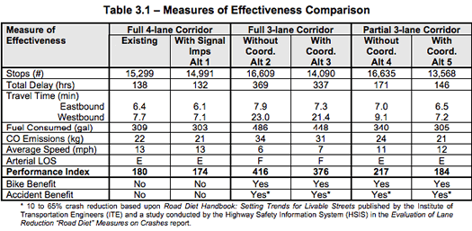
(The "performance index", as the report explains, "represents a combination of delay, stops
and queuing and is a method for quantifying overall traffic operations. A lower PI number
corresponds to better operations.")
The feasibility study looked at a three-lane configuration, and did projections based on reconfiguration with and without signal coordination. (You can look past Alternatives 2 and 3 because those were based on making changes to Western Ave, west of Madison Ave, which isn't in play.) And it's interesting that the analysis concludes that reducing Madison Ave to three lanes from its current four could potentially result in roughly the same travel time for vehicles -- if the signals are coordinated. (We're curious to see if that would be true for configurations that don't involve a middle lane.)
Wednesday night Trudeau told the crowd the city is currently working to incorporate signal coordination -- along with the new red light cameras -- into the road diet plan. So that's something to keep an eye on. And it might be some reassurance to people who are concerned the road diet will lead to backups and disruptive congestion -- something that came up during the public comments at the forum.
By the way: If you're interested in some of the specific numbers related to this project -- such as traffic and crash data -- that feasibility study is worth a look. Here's a pdf.
Whatever happens, it will probably be better than what's there now
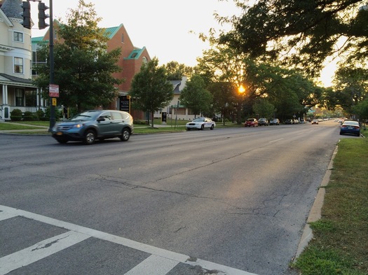
Madison Ave is sort of an odd case right now. It travels along a park, through the heart of the city, through some mixed-income areas with nice homes and a range of businesses. And yet... there's something about its scale and feel that just doesn't quite work. So whatever configuration option gets picked -- with whatever type of bike amenities -- it should theoretically help change the feel of Madison to something quieter, calmer, and more human scale. And that should benefit everyone.
What's next?
The city is accepting public comments on the Madison Ave Road Diet plan through August 15: MadisonAveStudy@albany-ny.org
The decision on how to proceed rests with the mayor Kathy Sheehan. Creighton Manning's Mark Sargent told the crowd Wednesday night that the goal is to implement phase one of the road diet -- that's the segment from South Allen to Partridge -- next year.
Hi there. Comments have been closed for this item. Still have something to say? Contact us.
Comments
As I posted elsewhere, many streets in the city have very little traffic. Many of these streets, from East/West and North/South could be converted to bike-only streets, without major disruptions to the flow of traffic. They would also connect all of Albany's neighborhoods. Only resident parking would be allowed on these streets, if necessary. Bike parking areas could be created along these routes, for bikers to stop and tie their bikes. New types of businesses could be encouraged along these routes, like cafes, ice cream shops, newstands, etc. because these streets would be closed to traffic, they would also be very friendly for pedestrians, and sidewalks could be enlarged to accommodate more pedestrians and outdoor sitting/gathering areas. It's quite easy to envision such project if one picks up a map of Albany and starts drawing lines along possible, low traffic streets. The implementation cost would be minimal, or at least much lower than carving large avenues. A couple of things would have to be addressed, like more street lighting for night riders (safety), and perhaps alarm stations (safety). As I mentioned before, it would also be nice to have an electric elevator riding along rails between Broadway and, say, Swan St., to negotiate that hill. While some bikers can walk their bikes up, older folks may have a more difficult time. A simple traffic study could turn the City of Albany into one of the friendlier bike cities in the US.
... said Joe A on Jul 30, 2015 at 3:52 PM | link
One con not mentioned in the non-separated bike lane alternatives: the likelihood of cars, delivery vehicles, police, and utility trucks regularly blocking the bike lanes. In other cities this is a huge and difficult to enforce problem, and given how rarely double parking is enforced around here, it's hard to imagine it not being an issue here.
Some cities use parked cars as a buffer for bike lanes, so they would be positioned as in option D above, but with cars rather than a permanent barrier to provide the separation. That would risk the same issues I mentioned above, but could reduce cost and maintenance issues, and should generate fewer "dooring" issues than traditional bike lanes (because bikes would not be traveling on the driver's side).
... said Sarah Rain on Jul 30, 2015 at 6:48 PM | link
I like plan c
... said Josh Michael on Jul 30, 2015 at 10:05 PM | link
I agree it would be nice to have some streets closed off to traffic- I've enjoyed these ideas in Schenectady and in Burlington VT However, you point out that these "bike only" streets would be available for parking to residents. That statement in itself means that your proposal is not in fact a "bike only" street.
... said MargieC on Jul 31, 2015 at 2:16 PM | link
@Margie:
agreed, it's not completely "car free." I don't think, however, that parking for residents only would significantly affect the safety of bike riders. How do you control that? Well, we would probably have to find a way, but one way is to color code the bike only streets and affix a large decal to the window or windshield of cars allowed to drive into and park on those streets. Any "trespassers" would be easy to identify and ticket. There are no perfect fixes, but I still think that taking part of our city streets back for our modern version of horse and buggy (for which they were created), without completely disrupting the lives of people who bought homes and rely on the as-is situation to park their cars, is a good compromise.
... said Joe A on Jul 31, 2015 at 4:14 PM | link
I usually do not bike on Madison Avenue but instead take either New Scotland or Hacket to New Holland/Morton via Pearl to downtown. I believe option D on Madison would be best solution if we could keep the third lane. Otherwise, option B is the best except cars attempting to park could disrupt the flow of biking traffic and create a hazard to both the driver trying to park and the cyclist. It would be safer to have the route on the right side of the parking lane. Plan C is the worst plan unless the two way bike path ran the entire length of Madison, with a safe way to return to correct side of the road once it ends. Even if the third lane has to be eliminated Plan D might be better than B. I can live with either one of these two, but NOT Plan C.
... said Hugh Johnson on Aug 5, 2015 at 7:12 PM | link