
The plan to connect two major bike paths at the Albany waterfront
Part of the plan includes a new multi-use path that runs through the space under 787.
Two major bike paths -- the Mohawk-Hudson Hike-Bike Trail and the Helderberg Hudson Rail Trail -- run into Albany's South End. But they don't connect. They're separated by roughly two miles filled with interstate off-ramps, truck traffic, and trains.
For the past year the city of Albany and consultants have been working on way to connecting these bikeways. And now there's a plan.
Quick background
Options from last summer's meeting.
The paved section of the Albany County Helderberg Hudson Rail Trail runs from Slingerlands to Albany's South End neighborhood, ending on South Pearl Street near Old South Pearl. That end point is just about two miles from where the Mohawk-Hudson Hike-Bike Trail picks up along the Albany riverfront, just south of the Dunn Memorial Bridge (near where the USS Slater docks).
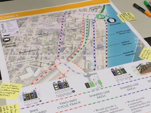
Last summer, the city of Albany and representatives of Alta Planning + Design presented a range of options for connecting the two paths. They broke the two-mile gap into three sections, with options for routing cyclists along each section.
This plan grew out of that process.
The plan
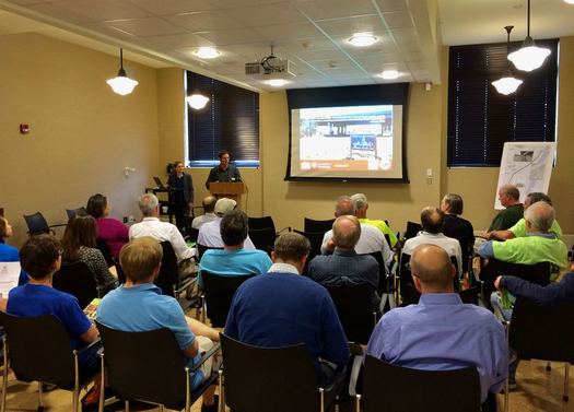
The start of Tuesday's meeting.
(We couldn't stick around for the public discussion part of Tuesday's meeting because we had to get over to another public meeting about police body cameras. If you were there and think there's anything to add here from that portion of the meeting, please do.)
So here's the plan introduced Tuesday evening at the Albany Public Library's Howe Branch for the Albany Waterfront Connector:
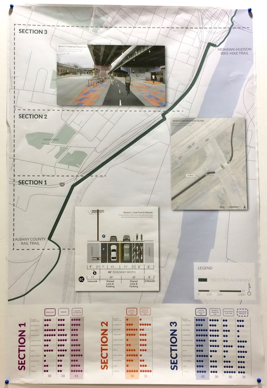
The overall route plan map -- and closeups of each section -- are in large format at the top. Click or scroll all the way up.
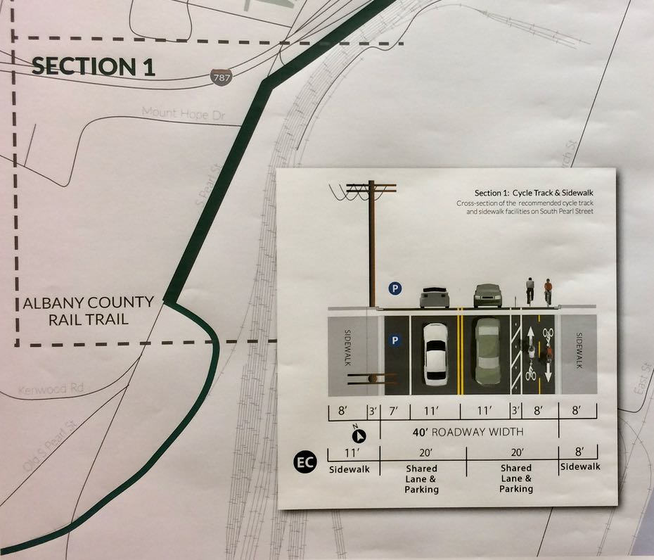
Section 1: Rail trail terminus to Mt. Hope Drive/787
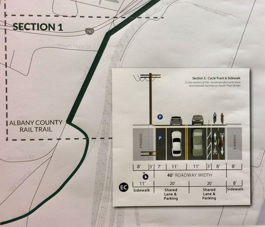
The plan calls for a two-way cycle track along the east side of South Pearl Street. Chris Spencer -- Albany's planning director -- said ahead of Tuesday's public presentation that this was preferred option because it can use the existing street there, which will be reconfigured to include the bike lanes separated by something along the lines of removable pylons. The option also wouldn't required bikes and pedestrians to cross South Pearl two times if they were heading to/from the rail trail.
One tradeoff for this option is that it will eat some of the parking along that stretch of South Pearl, though Spencer said parking around the Ezra Prentice Homes should be able to handle that.
Section 2: Frontage road along 787
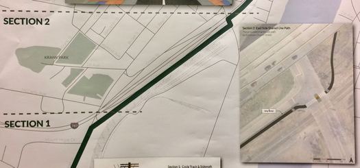
There were two options presented for this segment last year -- one that would have run along the west side of 787 and the other along the east side on a street that otherwise looks like a 787 on ramp. Spencer said the eastside route ended up the choice because the wide one-way street there had enough space to handle both vehicle traffic and the addition of a shared-use path. Vehicle traffic moves faster here, so the path will have some sort of sturdy barrier -- concrete or something similar.
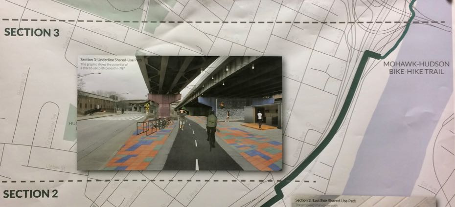
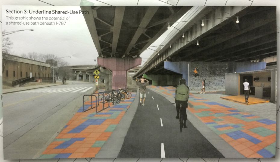
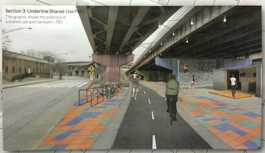
Section 3: Under 787 to the waterfront
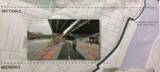
There were five options on the table last summer for this segment, each with some sort of complication ranging from cost to space constraints. The city ended up going with the option to run a shared-use path through the space under 787.
"It provided that natural separation. It provides an opportunity to start to activate under 787, to create better linkages between the waterfront and the areas near there. It didn't require a railroad crossing," Spencer explained. "And it's kind of a unique thing that cities have done, creating these linear parks."
The city has had its eye on spurring new development along Broadway and the riverfront in this section. But Spencer said the road currently has a number of pinch points and carries a lot of truck traffic. It will also probably be some time before there is anything like a boardwalk or something similar there, and he said the city wanted to move on the project now. But Spencer said if there's development along Broadway in the future, the multi-use path could be moved over there.
"In some areas where we thought longterm there might be a better solution, any place where you want to be along the water, [we wanted to] make sure what we're constructing is not so expensive that if we move to something else we're not prohibiting that."
Spencer said the overarching considerations in picking the path for the waterfront connector were accommodating cyclists and pedestrians of various skill and comfort levels -- some who are OK riding in traffic, others who are not -- and making a plan that could be implemented soon.
"As much as we want to dream big and look at all these great solutions, we can't always be pie in the sky. We want to be practical, we want to get things done."
Cost and timeline
Spencer said the estimated cost of the waterfront connector path is $1.2 million-$1.5 million. The city has various state funding lined up that totals about $840,000 of that and he said they're seeking the rest. And the city has already has bonding in place to cover the full amount so it can get started. (The state money comes in the form of reimbursement, so the city has to front the cash to do the project.)
The next step for the project is a request for proposals for the design and construction plans, the bidding out the actual construction. Spencer said they're hoping construction will start next spring.
More connections
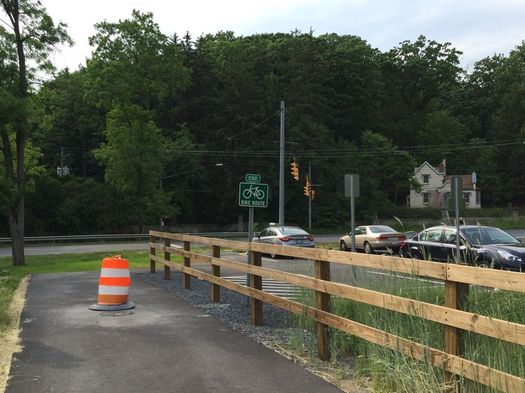
The Helderberg Hudson Rail Trail's endpoint in Albany.
Any plan is going to involve tradeoffs. And in the case of the plan for the waterfront connector, one of the tradeoffs of the selected route is that it doesn't run through the heart of the South End neighborhood.
That's an important point because the path should be something that's not just about moving people through the neighborhood, but also something for the people who live there -- even more so because there's already concern in the South End about issues related to the heavy truck traffic there. (There's currently a push to get the speed limit along South Pearl lowered to 25 mph.)
We talked with Chris Spencer about this angle on Tuesday and he said one of the important steps for the future will be identifying and highlighting points where the path -- which largely runs north-south -- can connect with east-west corridors within the South End.
"This is an opportunity for people to get into the neighborhoods and enjoy some of the commerce and things that are going on there. So part of this will be about signage, and the county has said it'd be interested in helping the city with the signage," he said, pointing to the example the Walk Your City-style signs downtown. "We want to make sure we're pointing people to points of interest outside the trail system."
The network
We've said this before, and we'll probably say it again: A bike path is fine. Two bike paths is better. But a system of bike paths, connecting within the city of Albany and to its surrounding areas, holds the most potential in helping foster a culture here in which a broad range of people, in a range of places, feel comfortable choosing cycling as a transportation option. And there's research from other cities that indicates the value of bike paths grows faster as the network they're connected to grows.
So the waterfront connector is a key link in the network here. The Madison Ave traffic calming project is an important east-west piece. And on Tuesday Spencer said the city will now be looking for other east-west bike routes to build on.
Say Something!
We'd really like you to take part in the conversation here at All Over Albany. But we do have a few rules here. Don't worry, they're easy. The first: be kind. The second: treat everyone else with the same respect you'd like to see in return. Cool? Great, post away. Comments are moderated so it might take a little while for your comment to show up. Thanks for being patient.
Comments
This is awesome!
I'm crossing my fingers that next they connect the Cohoes bike path to the Watervliet one. It would be so great to have a network of connected paths and hopefully if this is successful then more will be to come!
... said George on May 24, 2017 at 12:27 PM | link
I've been riding the two bike trails from Troy to Slingerlands and back almost every night when the weather is good. (And I keep going on the unpaved section to Voorheesville on the weekends.)
To get from the first trail to the second, I used to ride through the streets of the South End (and I've spotted some really cool buildings along the route) but lately I've been using the shoulder on the 787 ramp heading southbound and the shoulder of Rt. 32 northbound. (That sounds crazier than it is. Plus I have lights, reflectors, etc. But... concern trolls please feel free to post chastising comments about how horribly dangerous that is... I know you need to.)
Two important notes (if any planners are reading this). Last week a woman in a car drove up the bike path from the Dutch Apple intersection all the way to the visitor center buildings at the Corning preserve. She was driving about 40 miles per hour. She looked right at my friend and I as we scrambled to get out of her way. Her facial expression was totally casual, like nothing was weird. She didn't swerve to hit us. Just flew by, spewing up dust. I called the police afterwards and there are certainly videos of it. Friday May 12 approx 6:40 p.m.
Anyway, the point is... more bollards are needed at that section of the bike trail to block cars from driving onto the trail. Apparently the international green paint and all the other indications that one should not drive on the trail are not enough.
Second... I would like to see more official points of access and exit to the trail through the town of Bethlehem. Right now the Stewarts on Delaware Ave. has embraced the trail and the added bike and foot traffic to their location -- they have paved a little spur from the trail to their parking lot. I'd like to see more of these formal spurs, because the bike trail should be embraced as a means to get from Point A to Point B. It should not be viewed as a "thruway" with limited access. And it should not be considered a means for recreation and exercise only. I use it for recreation, exercise AND to get places. (That's going to be a hard sell for points where the trail enters private parking lots etc, because of the fear of litigation. But.. let's try to get as many spurs onto this trail as possible.)
Thanks.
... said Duncan Crary on May 24, 2017 at 1:02 PM | link
I'm a big fan of this route. In full disclosure I was part of the project stakeholder team and provided input as both a Planner and resident cycling advocate.
A few notes about this preferred alternative:
You're absolutely right that a plan is going to involve tradeoffs. A planner's job is to collect data (crashes, sidewalks, street widths, ROWs, speeds, road volume, etc. and etc.) and create a set of alternatives in response to community and stakeholder input. Then those alternatives need to be evaluated (safety, connections, desirability, level of service, cost, constructablity, ability to implement, etc.).
Finally, the art and science of planning is to evaluate and weigh all these factors and develop an alternative that achieves balance. In an ideal world 787 wouldn't be in the way of our waterfront - but it's removal is not going to happen in the next 5-years.
The Broadway route would cater to the waterfront in an in which residential and commercial development should eventually bloom, but that route would bypasses the South End and must cross railroad tracks that are frequently in use, blocked, and under jurisdiction of some very big hurdlemakers (railroads and state, federal bureaucracies). That being said, the city, and developers should still be engaged in efforts to capitalize on this waterfront street (our only one) to allow for development to occur with bike and pedestrian amenities to extend the network - in due time. There's still an opportunity to create everything we want to see here moving forward - but this will take years, not months.
The Green St. route is not expensive and it is tied into the neighborhood, but it would also be 100% on road which would highly discourage use by most trail users - a weak link in an otherwise strong chain. It also doesn't have to be mutually exclusive- can still, and should be built as part of the on-street network already emerging. The city should still pursue on street improvements and capitalize on any future street paving to implement them.
Is the under 787 route aesthetically pleasing? Not yet - but it can be softened (there are examples of how to in other cities), and aesthetics should be addressed at the time the trail is constructed. The improvements needed here are needed anyway (I kind of believe it's an EJ issue). It offers the best off-road continuity, avoids the RR crossing, and makes use of an area that would otherwise be neglected. It also creates eyes on the streets for an area relegated to an alleyway dump.
The S. Pearl area is a real unavoidable bottleneck because space is a premium. It's either on road on right behind the Ezra Prentice homes and in the RR yard. We're taking feet from someone's back door and on RR property in an active rail yard. The on-street alignment does sacrifice some parking, but this also opens up sight-lines for pedestrians and serves as a speed control measure. I believe parking can be offset nearby.
The under-787 alignment is able to be built as soon as 2018. That's lightning fast in rail trail years. It also doesn't have to be mutually exclusive - other bike connections can still be built - western approaches, like tentacles into the neighborhood, still need to be sought.
It's not easy, or possible to please everyone. Anyone that promising that is running for office without any experience holding office. Progress is not overnight. But this is a major step forward in the right direction and checks a lot of boxes for the trough rider and the neighborhood while addressing some critical blight. I think cyclists and neighborhood advocates alike should celebrate this as a success and continue to work towards the common goal of making the city more livable.
... said daleyplanit on May 24, 2017 at 1:09 PM | link
To back up Duncan, I've been seeing cars driving through the Corning Preserve (on "Jennings Landing" and down the path toward the parking lot) lately. Seems they are coming in through the cut curb by the visitor's center. This isn't really a surprise (spend enough time time in Washington Park and you'll see bewildered drivers around the Moses fountain) but the solution shouldn't be too difficult.
... said -B on May 24, 2017 at 2:10 PM | link
This plan looks fine but they have OMITTED a crucial feature for all good bicycle planning to successfully emerge in downtown Albany. By downtown Albany I mean the "flat land development" that runs up and down both Broadway and Pearl Street as parallel streets. Look around up and down both of those streets and you will NOT find one single anchored parking area for bicycles where the riders can chain up with high end locks, and then return from a shop or eatery and still find their bicycles at the same location. The misguided nobodies who are running all the path plans are conveniently leaving out all anchored PARKING stalls for bicycles. In the city of Washington DC, bicycle parking stalls are as much a part of the sidewalks as the car meters are for parking. Albany is apparently of the mistaken opinion that we can all use Sucker Poles which is exactly what all the Police Dept.'s recommend that we NOT use if we have sprung for a nice bicycle to use. I ride over to the Farmers Market at the bottom of State Street Hill at the SUNY Administration Bldg. There is ZERO anchored bicycle parking there and I have my hands full trying to shop for vegetables while keeping one hand on my bike. Get a CLUE, Albany, concrete embedded bicycle parking stalls are needed up and down Broadway and Pearl Streets.
... said Sue Frasier on May 24, 2017 at 3:41 PM | link
@daleyplanit - Can you further explain the issue with crossing the railroad tracks? Are you saying that riders don't want to come over the tracks? I ask because I did an informal count this morning. In the 45 minutes that I was able to spend there were 97 riders that came over the track. My point is that people are already doing it and these numbers were before peak commuter times. I can't even imagine what it's like after school lets out.
There is a much larger issue at play here - the City is doing nothing with this plan to address the safety of the pedestrians and cyclists that are using the Broadway corridor. Many people were direct with the planners - they WILL NOT use a path that runs under 787.
... said Ted on May 24, 2017 at 3:55 PM | link
And on a related, unrelated note, it brings to mind the possibilities of pedestrian and bike access over the Hudson River IF and ONLY IF Amtrak accommodates the additional "lane" when it replaces that old Livingston Ave bridge! (which they are actively planning to do)
... said jsc on May 24, 2017 at 4:48 PM | link
Like George, and as a member of the "river communities," I would love to see a connector between Cohoes and Watervliet. There was a study a few years ago about how to extend the bike trail in Watervliet, either by building onto the riverside trail or going with a separate lane on-road. Being able to bike completely off-road from Cohoes to Albany would be a game changer for me since I don't trust myself to bike through the Watervliet roads now.
... said Ryan H on May 24, 2017 at 4:49 PM | link
The problem with this project thus far is its lack of transparency. After the 6-2-16 public meeting, there was a complete communications blackout for an entire year, right up until May 2017. I know members of local advocacy organizations, and I'm a member of one myself; we couldn't find out anything; no one would talk to us, on or off the record. Their alleged website albanywaterfrontconnector.weebly.com/public-meetings.html was never updated, and no one ever replied to my inquiries.
At Tuesday's public meeting, a perfunctory two-minute slide show was presented, without any details re: pros and cons of the alternative routes. AOA said above: "We couldn't stick around for the public discussion part of Tuesday's meeting . . . ." In fact, there wasn't any "public discussion" - at least, not the kind we've come to expect for major projects. Immediately following the slide show, they adjourned to the corners of the room to talk to individuals; there was no public question-answer period. There have never been any plan documents posted on their website, so at present it's impossible to reconstruct their reasoning. Perhaps someone should file a Freedom of Information request.
My main concern is the northern third of the route. I urge everyone interested in this project to visit Church St. under I-787, on a bike or on foot, and make up their own minds (I recommend you come in pairs, during daylight; it's a very isolated area). Observe the present desolate condition of the area, the debris, and so on. Compare this to the artist's rendition of a future "linear park," and then consider that 3/10 of a mile needs major reconstruction, lighting, art work, and other amenities. Is all of this built into the budget? Because if they run out of funds, we will have merely a ribbon of asphalt through an urban wasteland. I hope I'm wrong - but they need to prove it before plunging ahead. It's all about due diligence.
... said GHS Albany on May 24, 2017 at 6:09 PM | link
Either Broadway or Green St would be a better option than under 787 for section 3. I particularly like Green because it could redirect cyclists from very dangerous conditions on South Pearl. Green Street is very wide south of Rensselaer and can accommodate bike lanes to ease any concerns of being "on road". As Green Street is less traveled, it would certainly be less stressful to riders than the bike lanes on the South Pearl area on section 1. Bike lanes on Broadway would certainly give visitors a better view of Albany than the underside of an Interstate.
... said Ed Brennan on May 24, 2017 at 9:50 PM | link
This is great to hear! I use both of the existing bike paths a lot, and getting them connected has been my dream. Hopefully Dan McCoy will be getting the Heleberg path paved all the way to Voorheesville this summer. That would just leave the Watervliet gap. I think NY state is going to have to own that project; it is doubtful that the city could ever afford it.
... said Bill on May 25, 2017 at 6:53 AM | link
Thanks for the information and the analysis. I am excited to see the bike network taking shape!
... said Josh Caldon on May 25, 2017 at 7:30 AM | link
This is great to hear! I use both of the existing bike paths a lot, and getting them connected has been my dream. Hopefully Dan McCoy will be getting the Heleberg path paved all the way to Voorheesville this summer. That would just leave the Watervliet gap. I think NY state is going to have to own that project; it is doubtful that the city could ever afford it.
... said Bill on May 25, 2017 at 8:12 AM | link
I would like to add that bike lanes/pathways on our bridges are non-existent and are not even talked about.
I was very saddened when the RT 2 bridge "makeover" some years back connecting watervliet-troy had zero thoughts for bikers. Drivers love zooming over this bridge and it's not safe.
... said Jake on May 25, 2017 at 10:41 AM | link
Now if we can connect Voorheesville to Schenectady that would be a 50 mile loop! Imagine that!
... said Chris on May 25, 2017 at 11:45 AM | link
Nice.
... said ethan on May 25, 2017 at 12:13 PM | link
Regarding Questions about Watervliet:
The city completed a bike master plan and a trail connection plan which can be accessed here: http://watervlietbikes.weebly.com/ The bike connector is funded (http://www.cdtcmpo.org/factsh16/A579.pdf) and is in design now. Not sure on construction dates.
... said daleyplanit on May 25, 2017 at 3:21 PM | link
As a commuter, I'll be happy to see a protected bike lane by the Prentice Homes. Since parking is not currently allowed along the west side of N. Pearl, I don't see a major loss of parking.
A protected bike lane along 787 is the best solution. The service road there could easily be one lane without any traffic disruption. It remains to be seen, however, whether they will maintain that section. Like Duncan, I use it currently and as far as I can tell, the city sweeps that road once a year, so it is strewn with glass and other debris.
I'm not sure I would use the under-787 section. I find that crossing the tracks and going up Broadway is perfectly adequate now. I don't see that the 787 option will draw me away from that route. As the most complex of the three section upgrades, I hope they'll leave it to last.
I appreciate that any plan is a balancing act. And I applaud the city for taking the initiative. These lanes should be just the beginning in Albany and the surrounding cities and towns.
... said Tom on May 25, 2017 at 3:21 PM | link
I second with the comments on needing more "on-ramps" and secure racks.
The glass, debris and cobblestones on the existing route are challenges, with the first two remaining with using the street lane option. Better signage for getting between the trails as the exist today would be a huge, cheap fix now.
... said vwbugman on May 25, 2017 at 3:27 PM | link
I ride these two trails often and I think this is a great solution. Right now I ride down South Pearl to the road on the east side of 787. Then I have to hop over the rr tracks and onto Broadway.
This plan will provide a barrier along the portion of the route that runs along 787 and then take you out of traffic altogether.
Thank You.
... said Mike in Delmar on May 25, 2017 at 4:06 PM | link
For those looking for a great proposal to connect Albany trails please read this 30 year-old proposal by Don Rittner. Still viable? Although the complete loop was not envisioned to carry bikes,, some parts (pine bush to corning preserve) would increase ridership from the suburbs to the city, and vice versa.
http://blog.timesunion.com/rittner/the-albany-greenbelt-revisited/4876/
... said KG_rider on May 25, 2017 at 4:57 PM | link
@daleyplanit wow, that's great to know. I had no idea. Thanks!
... said George on May 25, 2017 at 5:17 PM | link
Whichever route they choose, they should make sure the zoning will allow some restaurants, shops or other small businesses that will be worth stopping at. If the city will be spending that much on the project, they should make sure there will be some real return on the investment.
... said Zed F. on May 25, 2017 at 7:40 PM | link
"Many people were direct with the planners - they WILL NOT use a path that runs under 787."
Why? Just that it currently looks bad? Please. There is so much that could be done to make all of our downtown underpass areas nicer if there was demand for it. Lighting, public artwork, and smart, pedestrian-centric landscape architecture goes a long, long way.
... said Paul on May 26, 2017 at 10:34 AM | link
So glad to see that plans to connect up these paths will be implemented. I have run from the Pearl St. trail head of the Rail Trail up to the Corning Preserve, and there are dicey, dangerous crossings to get over there. Just want to weigh in as someone who *runs* on these paths, as these discussions seem to be very cycle-centric. Although I see the word "pedestrian" thrown in now and then, to me that reads as "these are bicycle paths where people can also stroll if they want to." I hope the planners will keep in mind that these are multi-use paths--for cyclists, runners, hikers, and strollers alike. And of course, the categories are not mutually exclusive, as my crazy triathlete friends can attest. I am sure the triathletes would appreciate having the secure bike parking for when they want to do a bike/run "brick" in their training. Something runners would definitely appreciate is clean public bathrooms along the paths--available all year round. And of course, these paths should be designed to accommodate both wheels and feet.
... said Mirkat on May 28, 2017 at 11:32 AM | link
@mirkat
Thanks for the note. The discussions have been dominated for cyclists, and there are a lot of other trail users. Developing a trail that will cater to cyclists, joggers and people with strollers is important and was taken into consideration. It's one of the reasons the fully separated trail, and not just bike lanes, was the preferred alternative.
... said daleyplanit on May 30, 2017 at 1:51 PM | link
Thanks for the response, daleyplanit. It's good to hear the planners have been keeping the multi-use in mind and favoring the separation.
... said Mirkat on May 30, 2017 at 7:18 PM | link