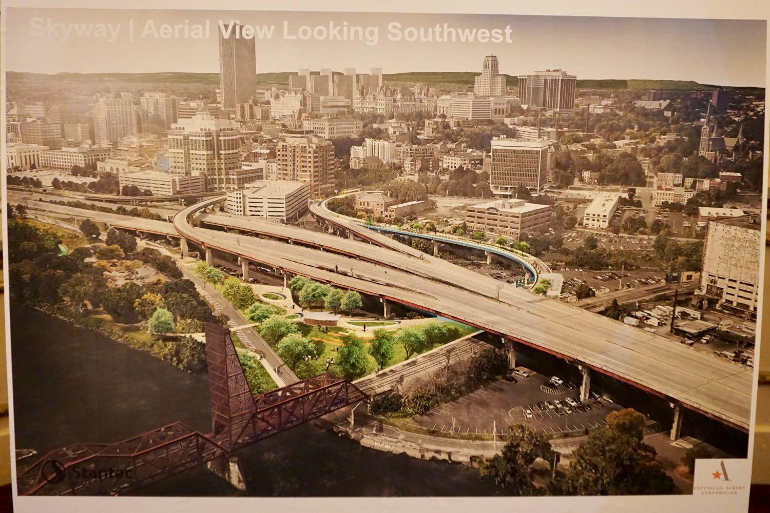
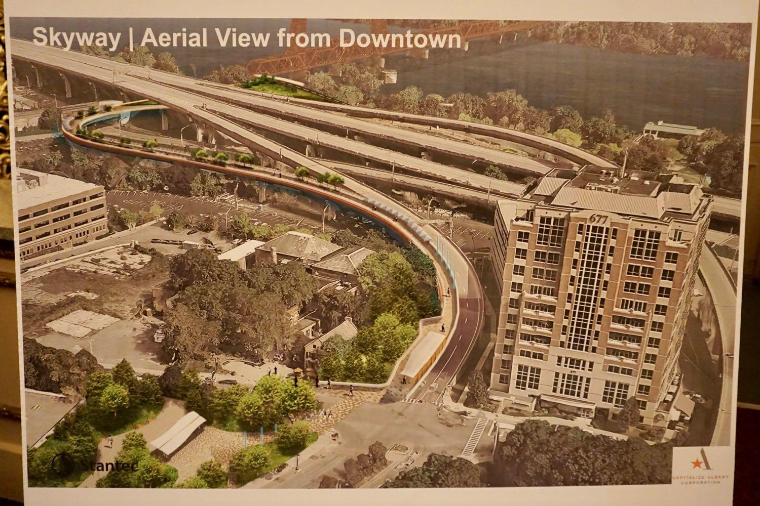
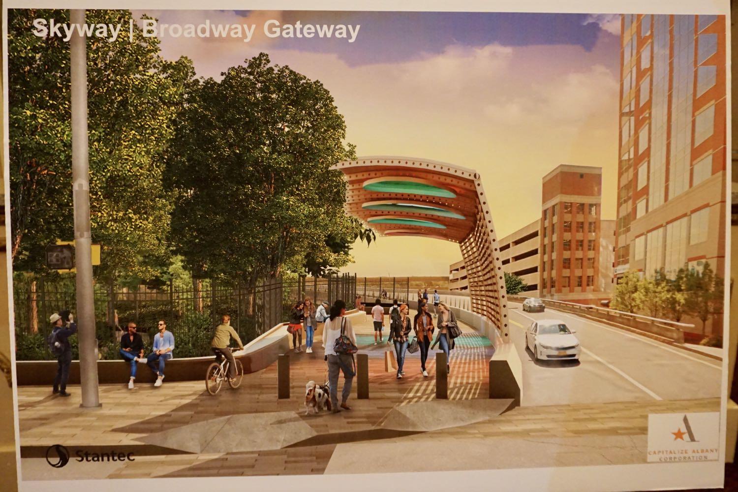
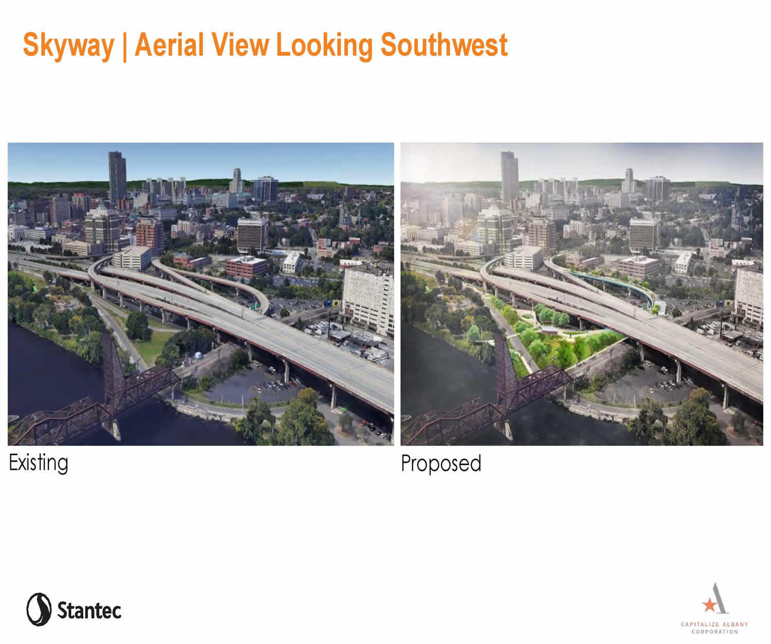
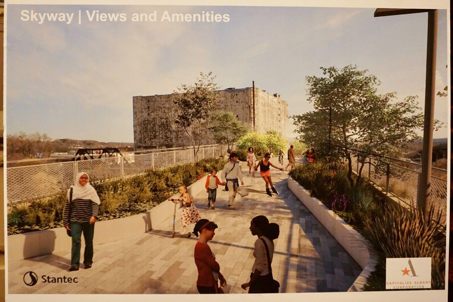
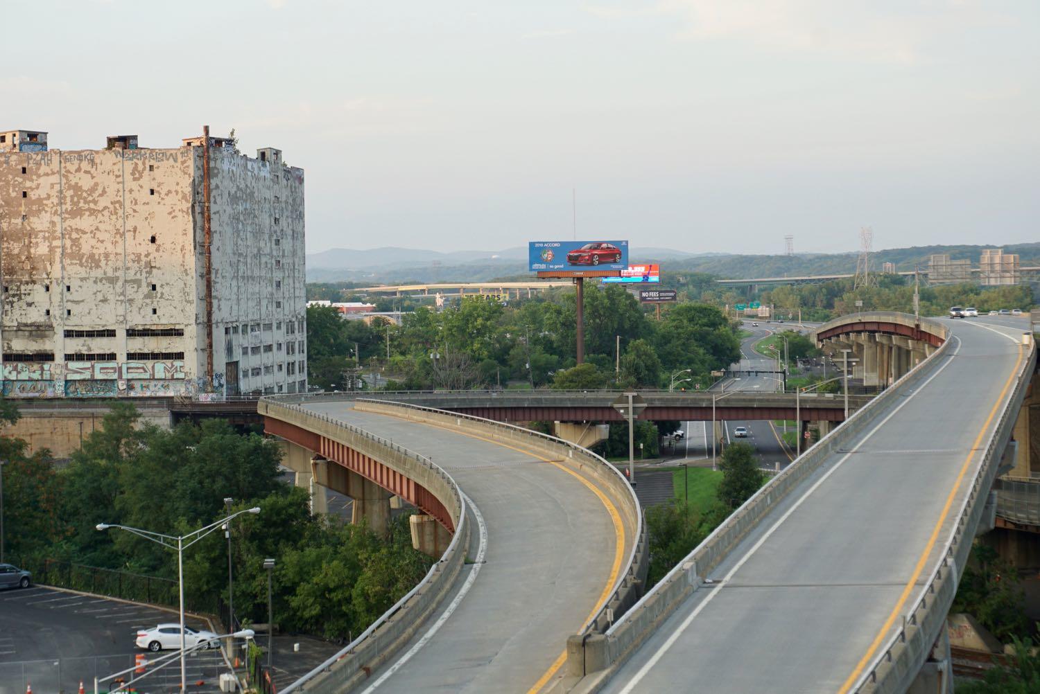
Here's the proposed design for the Albany Skyway
Over the years thousands of people have driven along the off-ramp leading to Clinton Ave in downtown Albany that's in line to become the Albany Skyway elevated park. But walked the almost half-mile curve? That's probably just a handful.
"It was an amazing surprise to be walking on the Skyway," said Capitalize Albany president Sarah Reginelli, one of the few people to trace the route on foot. "Even with none of the amenities in place, it was still this really enchanting walk because you get all of these vistas and vantage points you wouldn't otherwise."
Last week at The Palace, Capitalize Albany -- the city of Albany's economic development arm -- presented the work of the team that's been designing the Albany Skyway.
Here are a handful of renderings, bits about the design plan and cost, along with a few questions and thoughts.
What's in the design
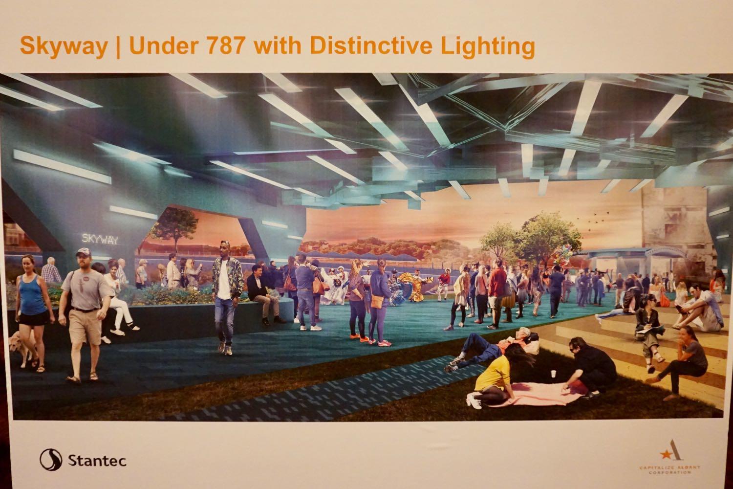
There are handful of design renderings at the top in the large format -- click or scroll all the way up.
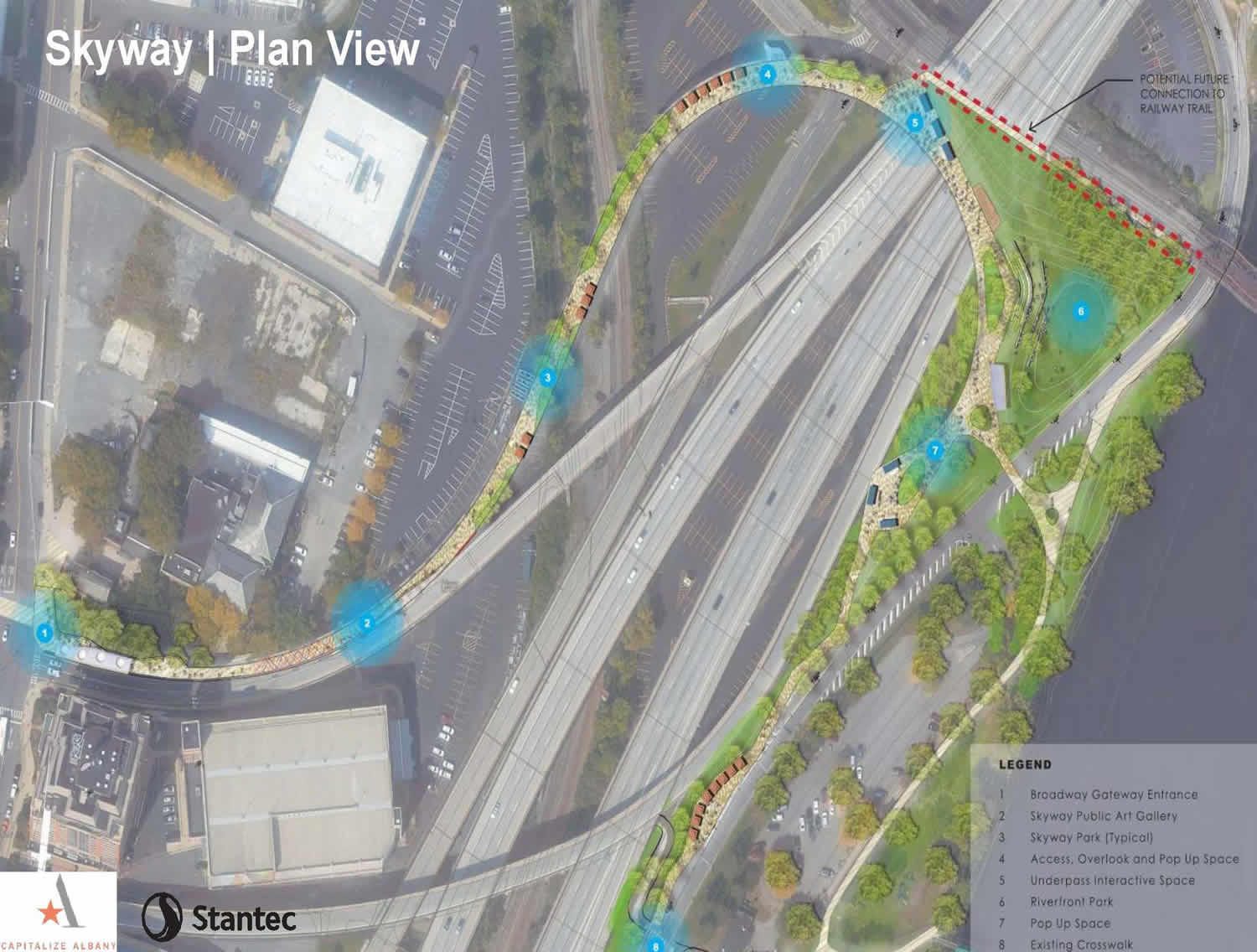
A layout for the ramp
Back in May the engineering/design firm hired to work on this project, Stantec, presented a range of options for the general direction of the park's design. And, based on public feedback, Stantec's Gary Sorge said the team ultimately settled on a combination of what it called "schemes" two and four.
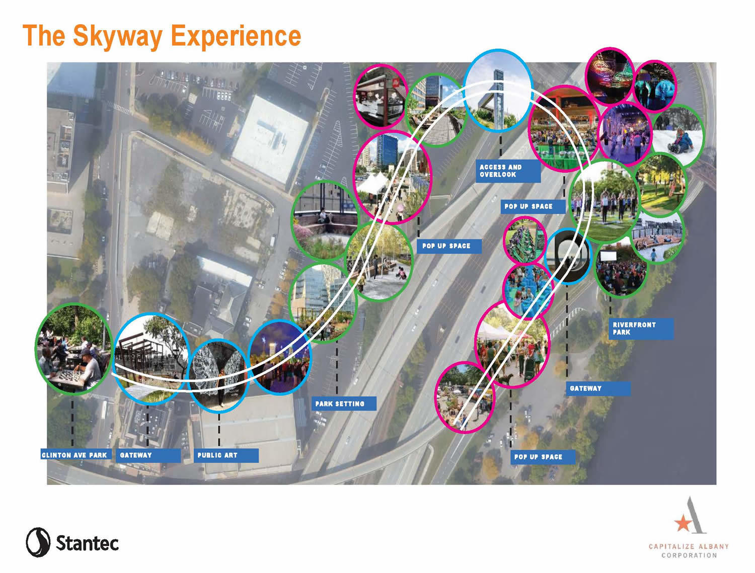
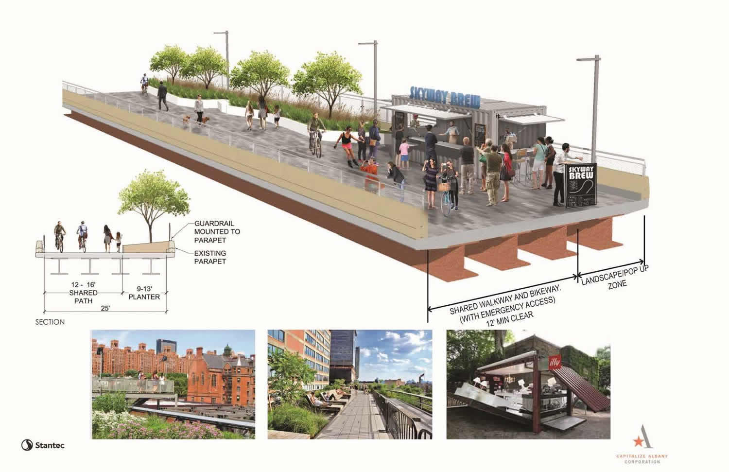
Essentially, the plan is to intersperse long stretches of linear green space along the sides with open areas that would allow for booths and pop-up events. And the stretches of green space would curve to allow space so people could step or stand to the side as others walk or bike past. (The width of the ramp is about 25 feet.)
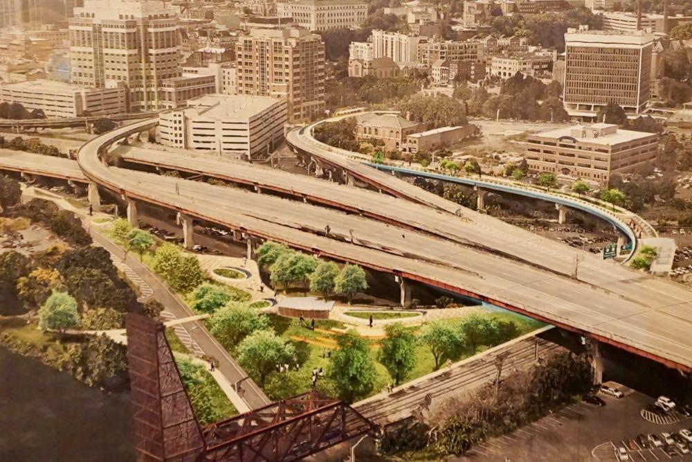
Reclaimed green space on the river side
The proposed design also calls for making more purposeful use of a wedge of green space that sits between the ramp and Quay Street on the river side. Part of this space could be formatted as an informal amphitheater-style area to allow for seating and viewing of the river.
Possibile amenities
Among the possible amenities proposed for the skyway:
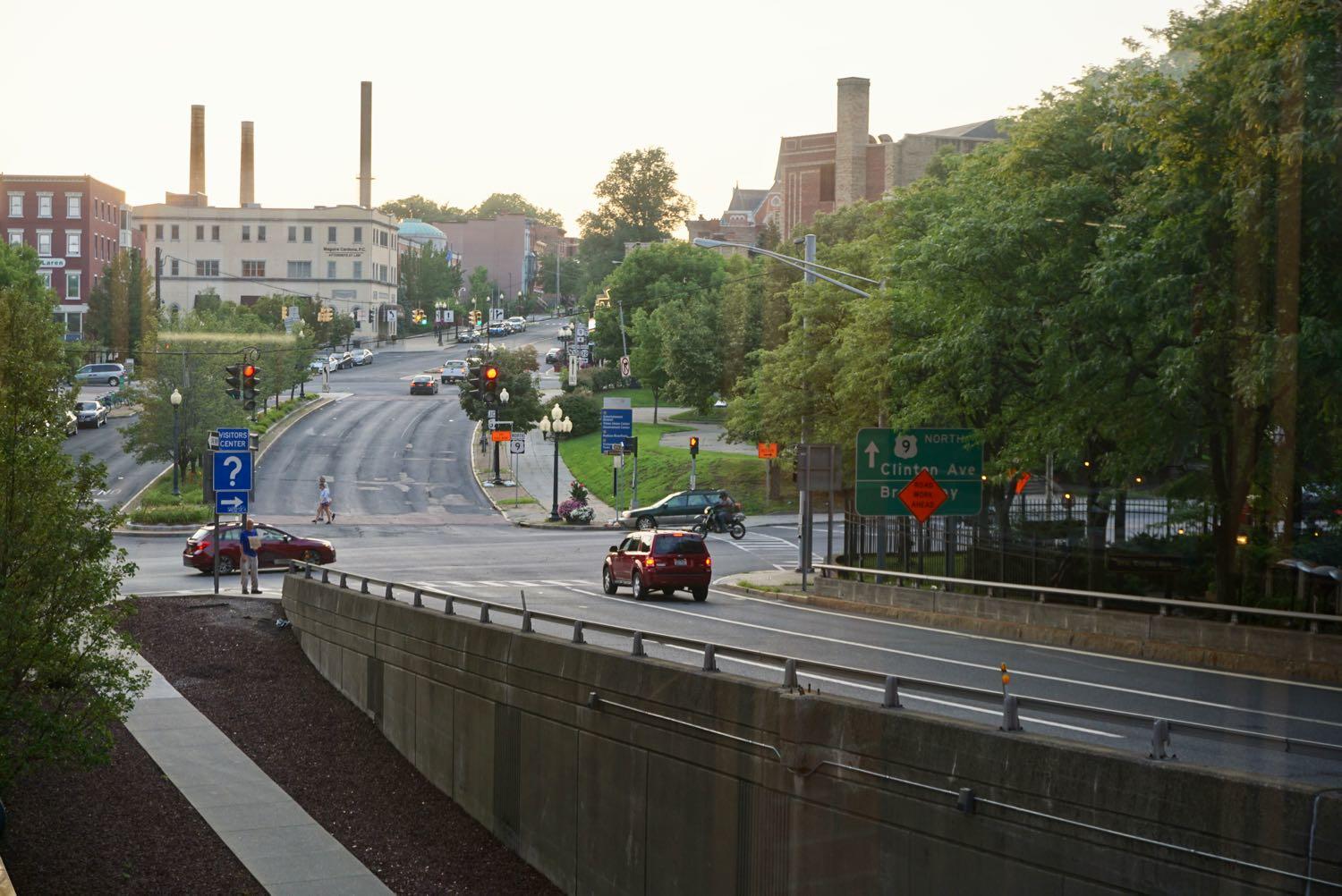
+ A covered entryway on the Broadway end. (Independent of this project, the city is also looking at possible new amenities for the Clinton Square area there, which could provide a welcoming link for people making their way to the the skyway from Arbor Hill and Sheridan Hollow.)
+ An outdoor gallery space for art along a narrow portion of the ramp toward the Broadway end.
+ Planters and landscaping -- the amount of greenery will be moderated in part by how much weight can be added to the structure.
+ Speciality lighting to create an eye-catching space where the ramp crosses under 787.
+ An elevator/stair tower at about the halfway point.
+ A pedestrian/bike connection to a possible pedestrian/bike walkway on the next Livingston Ave Bridge.
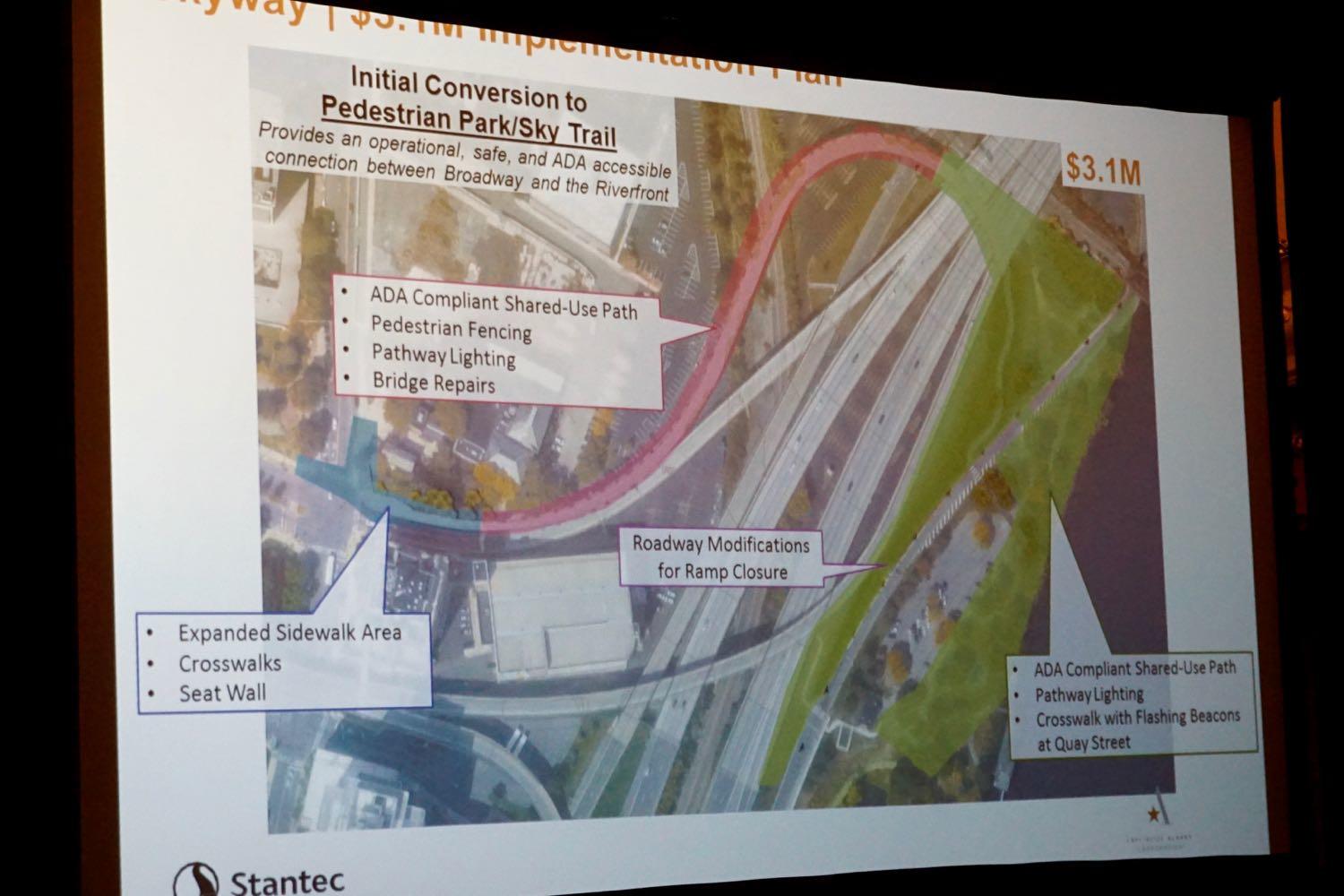
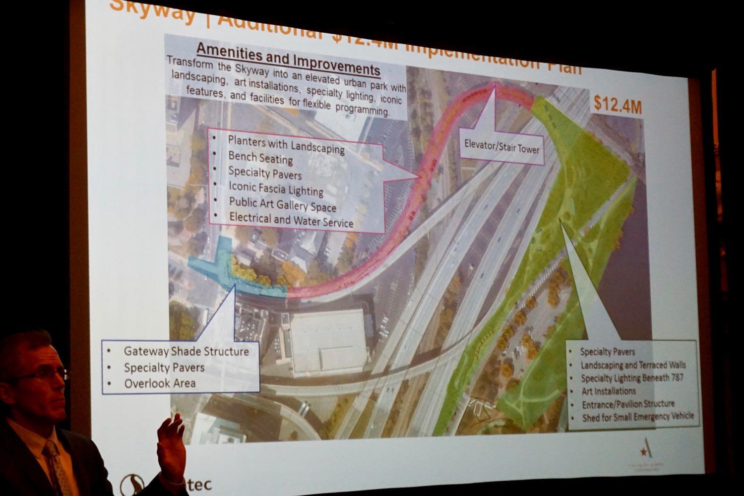
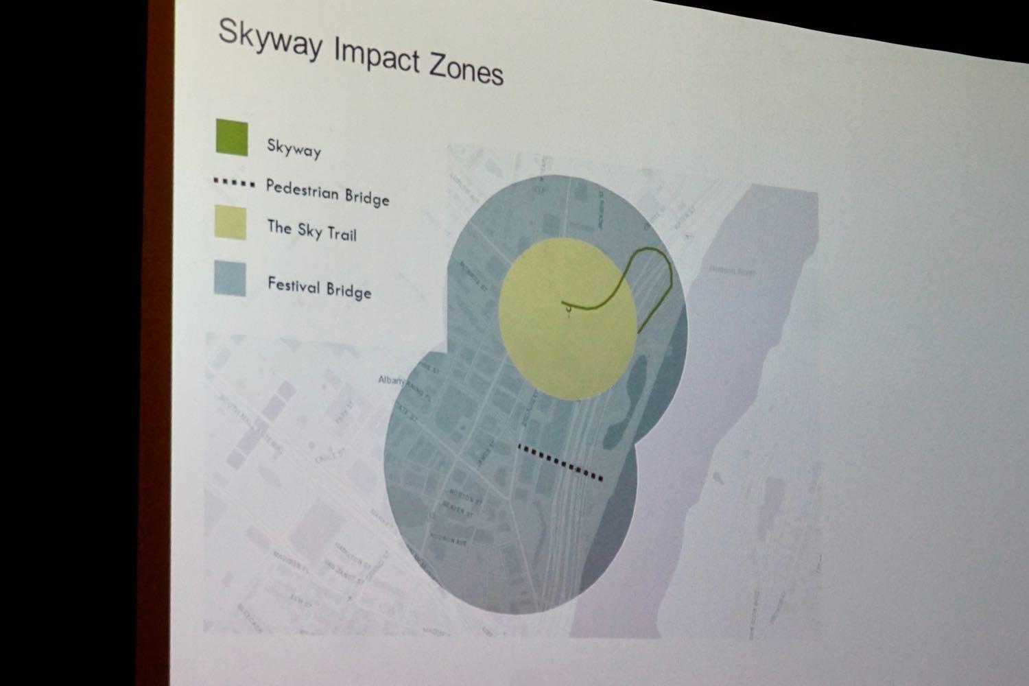
The cost -- in two parts
It's important to note that many of those possible amenities wouldn't necessarily be part of the initial version of the project. The designers have framed two possible phases or versions of the project as the "sky trail" and "festival bridge." There's more detail from back in May, but in short the "sky trail" version is the Albany Skyway in its most basic form as a walkway/bridge with limited landscaping. The "festival bridge" concept involves amenities and programming that would support events like farmers markets and small festivals.
And, as you might expect, they have different costs
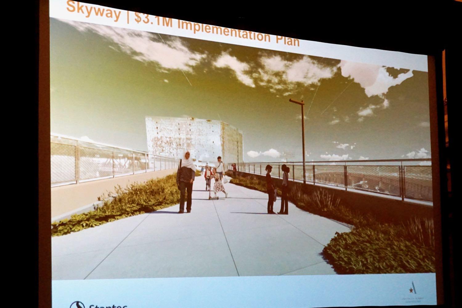
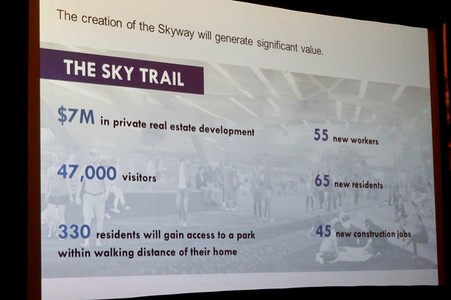
The sky trail
The Cuomo admin has already pledged $3.1 million to this project, and the design team says that's enough to make the sky trail concept work. As one of Stantec's engineers explained at the Palace last week, about $1 million of that will go toward initial maintenance and fixes intended to prepare the ramp for use as a park and set it up to be used for the next 15-20 years.
That figure caught the ear of people in the crowd, including Common Council member Judy Doesschate who questioned the team in a public comment about whether that $1 million in maintenance is work that the state Department of Transportation would have to pay for regardless -- and asked if maybe the state should be on the hook for that work independent of its $3 million pledge.
The team of designers and officials responded that some of this work wouldn't be done -- or wouldn't be done for many years -- unless the ramp is converted to a park.
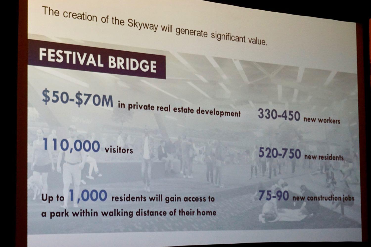
The festival bridge
Amenities rolled up in the festival bridge concept are estimated to cost $12.3 million. The city doesn't have money gathered for that, but Capitalize Albany's Sarah Reginelli said it's already applied for more than $5 million in grants through programs with the state.
"The way that the team had priced out that amenity package was to allow us to really see it as an a la carte menu of options for the Skyway," Reginelli said after the presentation. "So it didn't need to come all in one big, second piece. You can take pieces of that itemized budget and be able to find dedicated grant sources or corporate sponsorships or private donations to be able to cover individual portions so that if we're successful with the bulk of the state funding the city is requesting currently we'll be able to take care of much of that amenity package. If we're unsuccessful, or if we have a limited amount of success with that, we'll be able to start looking at additional funding sources to really build out the amenity package over time."
Figuring the payoff
To help assess the case for spending this sort of money, Capitalize Albany brought on Kate Collignon of the consultancy HR&A to work up some projections for the potential economic impact of the Skyway -- in both the sky trail and festival bridge versions -- based on the experience of similar projects in other cities. And Collignon ran through a quick overview of her analysis for the crowd at the Palace. These slides provide a rough summary (click for larger versions):
One of the reasons the festival bridge concept is project to have a large impact area is that, as Collignon explained, it makes other connections to riverfront -- such as the Maiden Lane pedestrian bridge -- more valuable as well.
One of the important considerations about the upping the level of amenities and programming on the skyway is that at some point it will probably require dedicated staffing for administration and fundraising and sponsorship sales. And which department/agency/org would do that hasn't been determined. Would that be the city? An existing org? A new Friends of the Skyway-type group?
"A project like this does take investment," said Sarah Reginelli afterward. "And this is a calculated investment on the part of the state and the city to create an amenity that drives returns to the city of Albany in the form of fiscal contributions from increased tax revenue, sales tax revenue, spending in room nights as well as well as economic impact and really raising the value of real estate surrounding the Skyway and allowing that to create an opportunity for new businesses to come in because they want to be located next to something so iconic as well as new residents as well. And that generates that indirect and induced spending in the community as well. So this is such a huge opportunity."
Questions of recurring cost and ownership
One of the numbers not mentioned at the Palace event was the annual cost for the city to maintain what would be a unique piece of infrastructure. (There was a projection that, whatever the cost, the city should expect to cover about a third of it as the rest could be made up from user fees and sponsorships.)
Reginelli said afterward that specific figure was not ready yet, but it would be presented to the city as part of the overall feasibility and design study. (It's worth noting that mayor Kathy Sheehan has supported the project and opened the Palace event with another expression of enthusiasm for it.)
That cost -- or maybe to be more specific, the uncertainty of that cost -- is one of the recurring criticisms/skepticisms of this project. Getting the number out there for everyone to see and understand how it could be covered could go some way to addressing those concerns.
Another important question that's not yet publicly resolved: Who will ultimately own this thing, the city or the state? Reginelli said the city and the state Department of Transportation continue to have discussions about the project -- the state DOT has been supportive of the project -- and figuring out the ultimate ownership arrangement is a key part of those discussions.
Again, settling this issue could go some way to addressing skeptics. That could be especially true if the ultimate arrangement allows the city some flexibility or assistance in handling a piece of infrastructure witch which it doesn't have a lot of experience. Maybe there's a lease arrangement or something similar that's possible.
What's the value of something new and different?
Zooming out a little bit: One of the things we were thinking about while listening to these plans and projections is how we value something like a park.
Sure, there are people who can make economic and visitor projections -- Capitalize Albany hired someone to do just that in in this case. (Though we're curious about how well those sorts of projections ultimately match up with reality.) And that's understandable, if the city/state/whoever is going to be spending a significant amount of money. However great a new amenity might be -- elevated park, swimming pool, unicorn petting zoo -- it has to make some sense within a municipal budget.
But that sort of analysis is mostly about attaching a dollar figure to something that might not necessarily be well measured in that way. What's the value of people in Arbor Hill having a shorter, more enjoyable route to the river? What's the value of providing a place for someone to spend a relaxing 15 minutes during their lunch break? How much is it worth to introduce a ribbon of greenery in a tangle of concrete?
Someone can probably attach dollar amounts to those things. And those amounts might even be accurate to the extent they can be figured. It's just that there's probably going to be a part of making this decision in which the choice isn't so much about return on investment as it is people expressing what sort of place they want their city to be -- and whether the cost is worth it in that regard.
Timeline
If this project stays on its current track, and the city and state can work out all the details by this fall, Capitalize Albany says the Albany Skyway could open in 2020.
Earlier
Say Something!
We'd really like you to take part in the conversation here at All Over Albany. But we do have a few rules here. Don't worry, they're easy. The first: be kind. The second: treat everyone else with the same respect you'd like to see in return. Cool? Great, post away. Comments are moderated so it might take a little while for your comment to show up. Thanks for being patient.
Comments
It's a nice idea, but the fact that the dilapidated cold storage building looms in the background (even of these renders) is sad.
... said T on Aug 14, 2018 at 9:32 AM | link
As someone that uses the riverfront bike trail daily, this is certainly a welcome addition to the area. I hope they add more CDPHP bike stations to compliment the Skyway.
Next I want to see a state grant to get the Livingston Ave Bridge replaced. Not only is it unsafe, but the addition of a bike path to the new bridge would be a boon for both sides of the river. How amazing would it be to easily ride a bike from Albany to downtown Rensselaer by utilizing the bridge and the Skyway?
I think the point about lack of current access to the riverfront cannot be stressed enough. There are only a handful of ways to access the riverfront, and they are terribly spaced out as it currently stands. If one wants to access the waterfront from Clinton and South Pearl/Broadway, you'd have to walk all the way down to South Ferry to access the park from Water St (which is a very industrial area that is unfriendly to walking traffic with it's lack of sidewalks), or to Maiden Lane and take the bridge (not ADA friendly, it's a bit of a trek).
... said Joseph on Aug 14, 2018 at 9:56 AM | link
I'm glad you brought up ownership. It is a sticking point for me with this project. There is maintenance with everything and the city of Albany doesn't seem to be able to maintain the parks they have now.
I also worry about multiple users on the Skyway...pedestrians, cyclists, kids, dogs...there is a lot of user conflict on the Corning Preserve / Mohawk-Hudson trail, but at least there is some room to move. There will be less space on the Skyway which could lead to additional conflicts and injuries. It happens. A lot. My 71 year old father is having shoulder surgery next month because of an injury he sustained on the Mohawk-Hudson trail (from trying to avoid a pedestrian who didn't follow trail etiquette).
... said Elisabeth on Aug 14, 2018 at 10:52 AM | link
It's creative, unique and encourages the city to interact with the waterfront more. It's great seeing this kind of thing happening in our area and I hope this project can act as a spring-board for many others in the future.
@Elisabeth: I believe the proposed Skyway path is nearly double the width of the existing Corning Preserve trail. If anything, this should be safer. That being said, as more and more people begin to use these trails, you should exercise caution as everyone gets up to speed on proper trail etiquette.
Can't wait!
... said Sean on Aug 14, 2018 at 12:54 PM | link
With regard to cost your article states, "the rest could be made up from user fees." Will there be a fee to access this site? Is this part of the proposal?
... said Joe Albany on Aug 14, 2018 at 1:24 PM | link
I think this is a great idea, and could be a great asset. It could also be a white elephant.
The real return on investment to the City is a vital question, though. The consultant should estimate how much revenue Albany can expect after completion, from taxes on improved property values and retail sales. That should be used to determine the design, construction and maintenance budgets. They may find that this project isn't worth the cost, and would be a burden rather than an asset.
Sean and Elisabeth, they should either traffic-calm it so cyclists will choose to slow down, or separate the two.
... said Zed F on Aug 14, 2018 at 1:36 PM | link
I use the Maiden Lane bridge every day and bike Mohawk-Hudson all the time, and I still struggle to see the appeal of a pedestrian bridge that goes alongside and then under a noisy highway, over parking lots and offers a view of Central Warehouse. Have you walked that elevated sidewalk along Water Street? It is not pleasant. And for as long as that ramp is, you could basically make it down to the Maiden Lane bridge in the same amount of time. I understand the need for more river access, but this very indirect. As a 787-should-be-a-boulevard supporter, take this with a grain of salt, but I see this as an expensive band-aid for a deep gouge.
... said Ryan H on Aug 14, 2018 at 2:01 PM | link
I'm always a bit dismayed when people from Albany immediately dismiss creative projects like this one. We should be open-minded to new ideas for revitalization, even if the costs seem steep. I especially like the discussion of benefits that can't be easily summarized in dollar amounts-- waterfront access, relaxation space for downtown workers, etc.
However, I just don't think this park is a good idea. I can't realistically see myself visiting a park that is essentially under a highway. It'll also mostly be in full sun in the summer months. After a novelty visit or two, I just don't see it attracting anyone. I hear the need for waterfront access, but I think it makes more sense to do that on the cheap and spend revitalization money elsewhere.
And the part about state vs. city ownership-- does anyone realistically think that Cuomo intends to direct any money to this after the ribbon cutting?
... said Jay on Aug 14, 2018 at 2:45 PM | link
I like the idea of this but I agree with Ryan that it will be noisy. I don't see a lot of people hanging out in this section but I'm sure it will get used as a path to the river.
I run down at the river every morning. Even on a Sunday at 6:30 or 7 AM traffic can be quite loud especially if the train is running under there. Sitting right on top of that doesn't seem very appealing.
... said K on Aug 14, 2018 at 3:24 PM | link
So the future booming population soon to be living just north of Clinton or even those now living in Arbor Hill or in Sheridan Hollow, when coming home north on 787 should now continue on Quay as it loops around to become Colonie. Take a right on Centre Street which turns in to Erie Boulevard, go past Eggys and take a left on North Lawrence then up to Broadway and left to Livingston or Clinton and on home? Once again we inner city folks are inconvenienced and overlooked to satisfy the wannabe NYC aspirations of white folks who do not live right here (which is not to ignore the fact that most of the new residents will be, I'm sure, perfectly lovely white people).
Please do not say to use the underpass and hit Broadway south of the D&H building and drive north. That is ludicrous. As is this whole skyway concept.
... said james on Aug 14, 2018 at 7:24 PM | link
Totally agree with Ryan H and james.
This being sold as "riverfront access" or green space is a complete farce. It will be for the new residential units near Clinton Ave & Broadway, and I guess bicycles, that's about it.
It might be nice to walk through, but then what? Turn around and walk all the way back? Walk all the way to Ferry Street or to Jennings Landing? It's not a useful connector for pedestrians. Even the existing pedestrian bridge is kind of pitiful in the sense that such a massive structure is needed for access due to 8 lanes or so of highway and a couple of rail lines.
... said Jeff D on Aug 15, 2018 at 11:55 AM | link
I've spent the past five years in the trenches advocating for a walkway across a rebuilt or reconstructed Livingston Ave. Bridge. I've visited similar facilities, assembled blue prints and maintenance plans for similar facilities, attended countless meetings and hearings and neighborhood association gatherings. I've presented to county and city legislative bodies, as well as to advocacy groups and at festivals. I've read thousands of pages of studies and reports and plans that include the Livingston Ave. Bridge replacement and recognize it's necessity. I've written dozens of support and comment letters, letters to the editor, created a website and post cards and flyers. And yet, one of the most mystifying questions I've gotten over the years was - how would anyone access the bridge from the west?
This.
The Skyway is less than 25 feet south of the Livingston Ave. Bridge's southern side, where the current walkway is now. The connection is also at grade. There's merely just a narrow grass trip that separates the walkway from the skyway. That's it.
The Sjyway could be the link between not only the downtown and the waterfront, but the City of Rensselaer to all the amenities on the west - and vice versa. Rensselaer's waterfront development is hitting high gear and now the promenade is complete a waterfront trail is not far behind. The Rensselaer to Hudson "Albany Electric Trail" will be under construction soon. The Livingston Ave. Bridge walkway, and the Skyway, would be true red carpet gateways into the City from the Nationally significant Erie Canalway Trail (and by extension the Champlain Canalway Trail). New trails have been booming - check out the Albany County Rail Trail on a Saturday - and provide a genuine potential revenue stream for businesses to cater to. They can relieve congestion when used for commuting and have been supported by the Departments of Health across the state for providing access to healthy places.
Make no mistake, NYSDOT does not want to continue to maintain this exit ramp. They're looking very critically at their portfolio - what Warrants state ownership? What can be jettisoned? This means Albany could either see the ramp demolished (still expensive) or donated to the city. Then what? Albany owns a seldom-used one-way ramp with alternative traffic flow options, or the city gets innovative. How can we turn a liability into an asset? How can we make this ramp part of the very hub of a trail network that connects Albany, Lake Champlain, New York and Buffalo? We have a very significant locational advantage at the crossroads, the hub of a statewide network. The Skyway would be a linchpin for that system and a bona-fide tourism magnet for Albany.
And, of course, it would directly connect our downtown with Rensselaer by way of the Livingston Ave. Bridge.
... said Daleyplanit on Aug 15, 2018 at 2:32 PM | link
Daleyplanit - what you're saying about connecting separate projects into a coherent system definitely makes sense. However I am a bit skeptical about using a horseshoe shaped ramp as a walking path since it becomes a quite long walk for what seems a shorter journey. A mile in a car is not too far, so ramp is not too long. A mile on foot is a good 20 minute walk...
... said Mike on Aug 15, 2018 at 3:13 PM | link
Can hardly wait to have access to Rensselaer.........
... said BS on Aug 15, 2018 at 4:35 PM | link
HereHere @ Daleyplanit!
@Mike...the total ramp length from Quay street to Broadway is less than 0.5 mi. Per the plans shown, it appears pedestrians would be able to exit the ramp into greenspace about 1/3 of a mile from Broadway, and would intersect the bike trail at ~0.4 mi. So, no, it doesn't shave any time off of a trip to jennings landing in comparison to the Maiden Ln ped bridge, but it's still a viable way to access the waterfront from downtown for pedestrians. Add in CDPHP cycle and I'd expect the skyway to see quite a bit of traffic with or without additonal amenities.
... said Ed on Aug 16, 2018 at 10:08 AM | link
While at a press event with then assemblyman Jack McEneny, he said something about the Dunn Memorial that stayed with me. Paraphrasing here...
"No one wants to stop and admire the view from the Dunn Memorial, even though it's a good view (if not for the chain link). It's because it's not a pleasant place to be. There's a lot of noise and traffic just a few inches away. You want to rush through. It's not a place you want to be. The Livingston Ave. Bridge walkway would make people stop, admire the River and the waterfront. It will be a place people want to be."
I think about this every so often. The Walkway, even more so than the LAB, isn't just about the destination, it's about the journey. The journey matters. It's not about getting from A-B as fast as you can in a park, it's about the experience. Placemaking is about creating places people WANT to be, not where they HAVE to be. Charles Kuralt once lamented "Thanks to the Interstate Highway System, it is now possible to travel across the country from coast to coast without seeing anything." The Skyway is not a highway. It's a destination unto itself.
... said Daleyplanit on Aug 16, 2018 at 10:21 AM | link
I have to throw my two cents in with James and Ryan. While it's a nice idea, the surrounding area is a sea of parking lots, railroad tracks, and urban congestion that are ultimately a permanent part of the landscape. Having more access to the waterfront is a splendid idea, but this does seem like a really roundabout way of doing so, in an area that doesn't really fit it logistically (I appreciate that no area really does with the way 787 is set up).
It's one thing to say what a huge success it would be and how much use it would get, and if it does get built I certainly hope it is a success, but I have to imagine the number of regular users would not come close to the number of displaced drivers who use that "seldom used" ramp on a regular basis to gain access to downtown. I used to work in Arbor Hill and traveled a lot and drove that ramp multiple times a day. It was always pretty busy, which makes sense since it's a major gateway into downtown from the south - even cited in other articles on this site as such - hence the bluebird mural to make it feel more welcoming. Yet now you would be halving the amount of traffic that use that access point to Arbor Hill, Palace Theater, downtown etc from the south.
And to anyone who says drivers from the south can just get access further south below the D and H building and just "drive a little further" - there is a project to spend millions of dollars to build an offramp on the northway JUST to have an expedited route to the airport so that drivers can "drive a little less." This seems like the exact opposite of that.
@Daleyplanit - I agree that the Livingston ave bridge should be redone to allow pedestrian access. If that were to be accomplished, then I could see the pedestrian traffic in the area possibly increase enough to warrant another look at project like the skybridge. You bring up access from Albany, but my question is - what would be the access from the East of the Livingston Ave bridge? It more or less just dumps you into the Amtrak service rail yard with no clear opening to Rensselaer.
... said Paul on Aug 16, 2018 at 12:56 PM | link