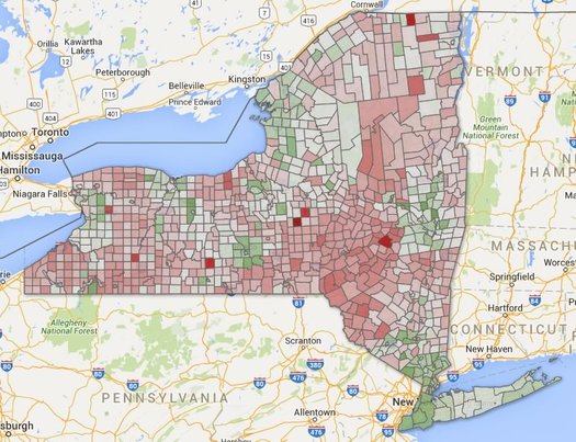
A quick look at city and town population changes

There are large, clickable maps after the jump. (Because of course there are.)
The topic of changing population popped up in comments earlier this week, so we figured it'd be interesting to whip together a clickable map of some new numbers for city and town population changes both here in the Capital Region and across the state.
And it turns out the Capital Region is a bit of an outlier.
Let's have a look...
Look up for the maps
There are two maps above in large format -- click or scroll all the way up.
A few bits
+ The Capital Region core is one of the few regions upstate to see estimated growth since 2010.
+ Saratoga County is leading the way in the Capital Region -- up a little more than 3 percent over that time. It and Tompkins Count (Ithaca) were the two fastest-growing upstate counties.
+ The towns of Halfmoon and Ballston both had relatively large population increases by percentage -- Halfmoon up more than 10 percent, and Ballston up 9 percent. Those increases rank #1 and #3 among the state's cities and towns.
+ The Capital Region cities and towns with the largest estimated increase raw numbers: Halfmoon (2,191), Colonie (2,059), Bethlehem (1,220), Saratoga Springs (1,200), and Ballston (879).
Earlier
Say Something!
We'd really like you to take part in the conversation here at All Over Albany. But we do have a few rules here. Don't worry, they're easy. The first: be kind. The second: treat everyone else with the same respect you'd like to see in return. Cool? Great, post away. Comments are moderated so it might take a little while for your comment to show up. Thanks for being patient.
Comments
Love it. Spent entirely too much time trying to do something similar with census tract data in Albany. Either I'm really dumb (strong possibility), or the 2014 tract data isn't available yet (what I found exactly matches the 2010 numbers).
This is really interesting stuff and a nice visualization, but so tough to draw any real conclusions from.
... said -B on Jun 9, 2016 at 10:53 AM | link
Very interesting! I'm wondering what (software, app, etc.) you used to actually map the census data?
... said J on Jun 9, 2016 at 1:24 PM | link
@-B: Using the Census American Fact Finder tool (which isn't really the easiest thing to use), I was able to get Albany County tract data on population based on the American Community Survey (I think/hope that link will work). I think that's a somewhat different estimate from the estimates used here, but there are now two non-overlapping 5-year ACS spans, so it could work.
@J: The short answer is a spreadsheet app and Google Fusion Tables. You're not the first person to ask, so I wrote up a tutorial last year about how we make the maps.
... said Greg on Jun 10, 2016 at 5:56 PM | link