What's up with the Albany Skyway, and a few bits about plans to makeover a key piece of downtown
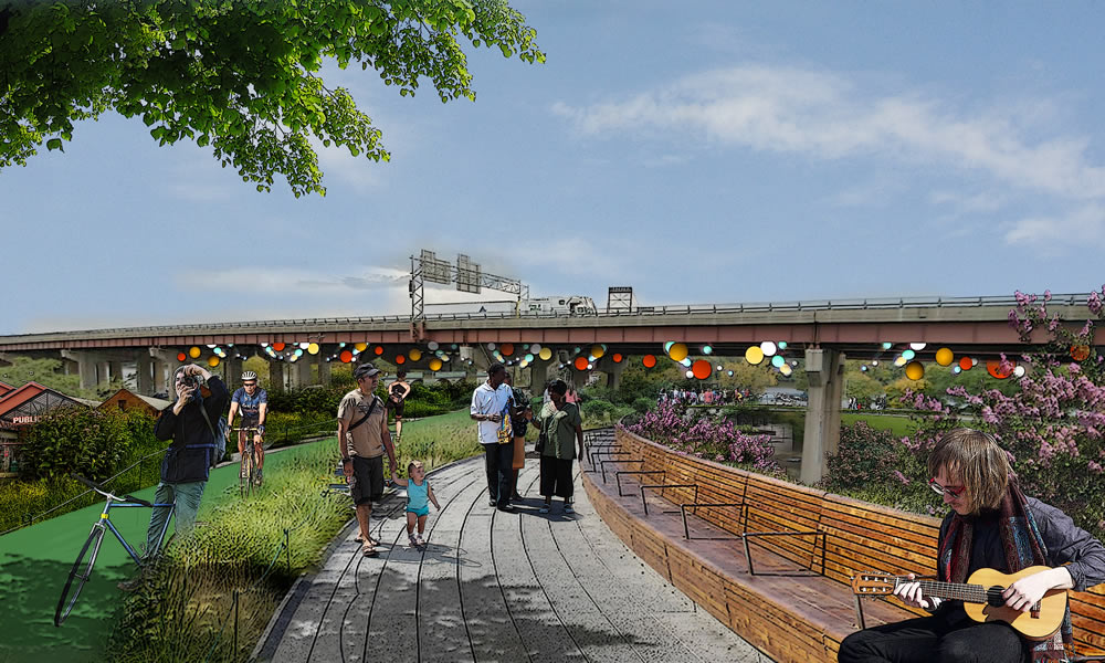
A rendering of what the skyway project might end up looking like.
The Albany Skyway project -- which aims to turn a lightly-used off-ramp into a linear park connecting downtown Albany with the riverfront -- is set to take a step forward next year.
And the skyway is potentially one piece of a larger puzzle that officials are looking to rearrange with the hope of creating better links between parts of the city.
Here's what's in works...
Albany Skyway
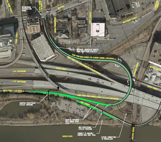
The green marks that ramp that would be repurposed.
Last Friday, Capitalize Albany -- the city's economic development org -- posted a request for proposals for the design, planning, and engineering of the Albany Skyway project. (Here's backstory on the idea.)
From the RFP:
Capitalize Albany Corporation is requesting proposals from qualified Respondents that specialize in road and bridge design, planning and engineering consulting services to complete Phase I of the Albany Skyway project - a transformative regional project that will ultimately result in the conversion of the underutilized northbound exit ramp from I-787 from Quay Street to Clinton Avenue into the Region's first and only highline park. The subject property is a 0.5 mile (1,850 ft.) section of underutilized elevated interchange ramp, which is part of the I-787 infrastructure built between 1960 and 1980. Upon conversion, the former ramp would serve as a landscaped promenade, bike route, foot path and linear park making valuable connections, dramatically increasing accessibility to both downtown and waterfront.
Responses are due back January 12. And the RFP notes the design project is expected to take 4-6 months.
The design and engineering work is being funded by a grant from the state Office of Parks, Recreation and Historic Preservation. The city would then have to seek funding for the actual construction, which earlier estimates have pegged at $5 million-$12 million. (The project could be phased, so the basics could be done and then more amenities added later.)
Clinton Square as a gateway
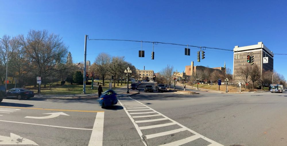
That the skyway would open another pedestrian-friendly link between downtown Albany and the riverfront makes it a notable project on its own. But city officials are eyeing it as one piece of a potential makeover of a section of downtown that's already important -- even it doesn't necessarily register as such right now.
"We always tell [people], close your eyes and picture coming off of 787 into downtown," said Sarah Reginelli, the president of Capitalize Albany, last week. "And you can see this amazing skyline in front of you as you're coming off of the flyover, and land at the base of Clinton Avenue. And you really don't know where to go from there."
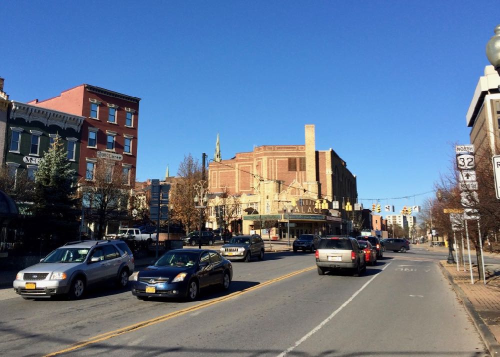
So Capitalize Albany has been looking at ways of potentially transforming what it's calling the Clinton Square section of the city. (That little triangle of land in front of the row that includes McGeary's on Pearl Street in already called Clinton Square.) That could mean new amenities, new uses, or just plain making that area look better.
Reginelli said that corridor is a focus because it's the meeting point of multiple neighborhoods.
"So if you think about it, that intersection right at Clinton and Broadway and Clinton and Pearl, that brings people in from around the region coming off of 787. It brings Arbor Hill and Ten Broeck Triangle in together with Sheridan Hollow, downtown connects the warehouse district. It's a really critical point of connection."
And there's a lot that's been happening in those neighborhoods:
+ Downtown is experiencing a mini-boom in residential redevelopment.
+ Sheridan Hollow has seen the creation of a new neighborhood center as part of project led by Habitat for Humanity Capital District.
+ A company called Home Leasing has been moving toward a large-scale revitalization of housing along the Clinton Ave corridor in Arbor Hill.
+ The Albany Housing Authority is redeveloping large portions of the Ida Yarbrough Homes a few blocks north on Pearl, with Capital Rep renovating a work space across the street.
+ The section of the city between downtown proper and the Warehouse District has the 760 Broadway new-construction residential project underway (now planned for 88 units) and the large mixed-use development at Quackenbush Square is moving through the planning process.
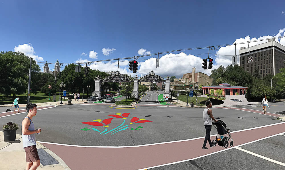
What this corridor could look like, maybe, someday. (You can click the photo for a larger version.)
Reginelli said all that activity -- with the Clinton Square corridor in the middle -- prompted the city to make the area its focus in the state's Downtown Revitalization Initiative. And while the city didn't win -- Hudson got the $10 million grant the last time out -- it's been looking at how to make pieces of that plan work.
Among the ideas Reginelli said are at the forefront right now: Whether there are better ways to use the strip of land that sits between Clinton Ave and the federal building. She said the city is hoping to get money through the Regional Economic Development Council process for a study of uses such as a three-season market or something similar. "We want to be able to look at what the options are there to be able to create a presence as everything sort of grows up around it."
Other things up for consideration: better signage -- and maybe even eventually a gateway for the city. That rendering above shows one vision of how such a gateway could look. Reginelli said it doesn't depict a specific plan, but rather was created for the purpose of prompting thinking and discussion about the idea. (The gates in that rendering were inspired by gates in Nijmegen, Albany's sister city in the Netherlands.)
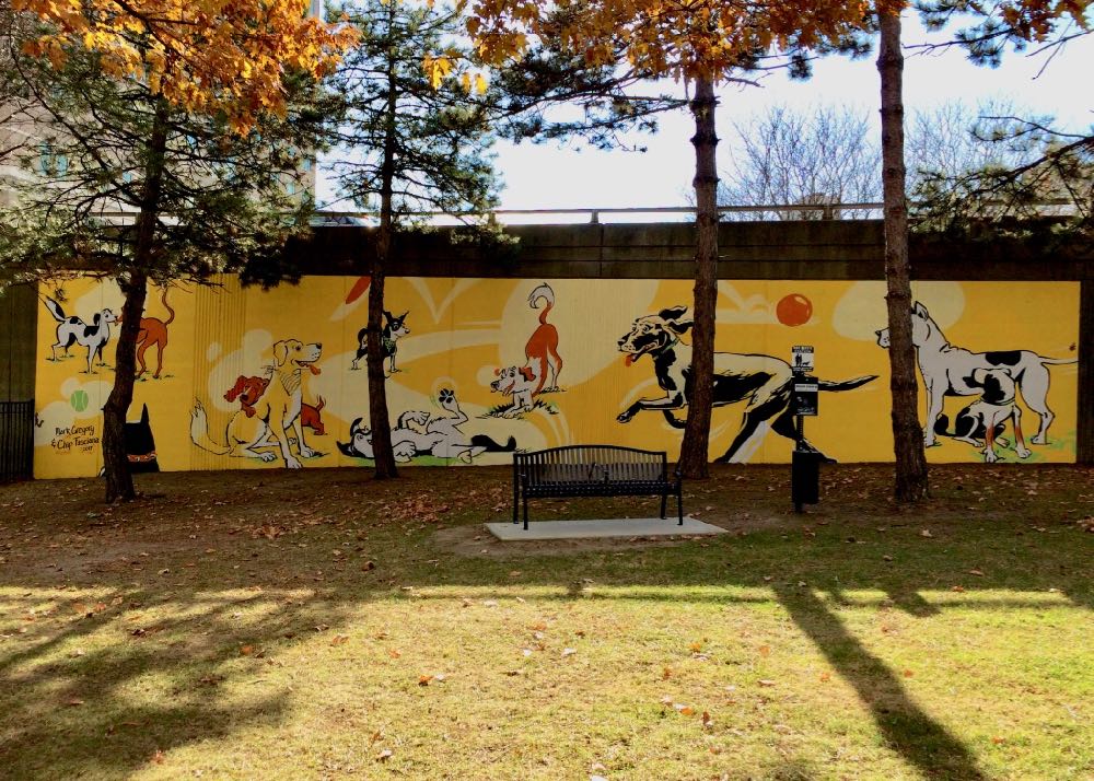
Reginelli pointed to the new dog park at the spot on the south side of Clinton Ave as an example of how new amenities can change the look and feel of a place.
"Having that mural in place that can really humanize the sort of massive infrastructure that you see there, it's approachable and it lends to that welcoming feel and the walkability of the area."
Zooming out a bit
That section of the city between downtown proper on the south, Arbor Hill to the west, and the Warehouse District to the north is sort of an odd in-between space. At the moment, it includes a bunch of empty lots, large chunks of parking, bisecting railroad tracks, and a constantly dripping rail overpass. (Why is that overpass so drippy?) Central Warehouse looms on the north end, 787 walls off the east. It also doesn't really have a name -- thus the effort to expand the Clinton Square designation.
And yet there's a lot in the works there, and there's a lot going on around there. So maybe we're at the beginning of a phase shift for the (insert name) neighborhood into something new and different. That means this is a good time to be thinking about its direction, and how this momentum can also benefit the people already there and nearby.
Hi there. Comments have been closed for this item. Still have something to say? Contact us.
Comments
I love love love this idea. I really hope it comes to fruition.
... said Danny C on Dec 12, 2017 at 10:58 AM | link
That guy with the camera better watch out. He stopped is bike right in the path of other cyclists.
... said Tim on Dec 12, 2017 at 11:53 AM | link
This is neat idea to connect downtown with the Riverfront. with such low traffic volume it's an albatross for DOT - hopefully a harbinger of better things for 787 but no one will hold their breath just yet. Pity it can't get us across the river.
But what's that? There's something less than 25 feet away that could get you across the River? And it's at grade?
... said daleyplanit on Dec 12, 2017 at 12:57 PM | link
Woohoo! I’m glad all of these ideas are kicking around.
How about the Palace Neighborhood? It’s less of a mouthful, and that marquee is rather…conspicuous. Even newcomers would be able to identify the neighborhood.
Praise be! I’m glad they’re thinking about putting in a bike lane on the westward lane at the base of Clinton Ave. I hope it connects with the bike lane above the intersection with Ten Broeck Street, because I’ve been nearly driven off the road a handful of times in that unmarked stretch between Broadway and Sweet Pilgrim.
... said Ian Benjamin on Dec 12, 2017 at 2:52 PM | link
It's a definitely a start. Liking the thinking. The innovative redevelopment of unused/underused spaces only stands to benefit a city and its region, serving as an inspiration to others around the world. Mix that in with the addition of more parks, greenery and public spaces and you've got a higher quality of life across the board.
However, this project's planners will have to take a serious look at the future of 787 and its implications on the region, local residents/neighborhoods, city aesthetics, etc. Constructing this may distract from the bigger problem that is the 787 as it would virtually accept the existence of the 787.
... said Matteo on Dec 13, 2017 at 1:33 AM | link
@Matteo
Look no further: http://787waterfrontstudy.blogspot.com/
Next step - ensure there are some recommendations from this study that result in progressive deliverables and hold decision makers accountable.
... said daleyplanit on Dec 13, 2017 at 10:35 AM | link
Here's the idea to which daleyplanit alludes above about a river crossing. It's a good idea.
@Matteo: That 787 study daleyplanit pointed to is now tentatively scheduled to be released sometime in January, according to an official I emailed with last week. And there will be a public meeting to along with it to offer feedback.
... said Greg on Dec 13, 2017 at 4:37 PM | link
This 'skyway' is thoughtless hipster nyc/High Line envy. Have you been to the High Line? It's an anti-urban (it's still ELEVATED) white folks tourist romper room and a "failure with zero connection to the neighborhood below" (the last according to Robert Hammond, the co-founder of the High Line). But more important is how the planners and the commenters above blithely dismiss the needs of the residents of Arbor Hill (I live on North Swan), Sheridan Hollow, Ten Broeck Triangle, the tall condos on Chapel and Lower Sheridan, and our future neighbors in the big development on North Pearl. Coming north on 787 arriving home from NYC/Thruway or Hudson or the Train Station or the closest major shopping (9W in Glenmont), now we slide right onto Clinton and on to our respective hoods. With this plan it is Quay Street to Colonie Street (never even plowed), right on Erie, left on North Lawrence, left on Broadway and back across Livingston to our areas. All so the folks in Guilderland and Clifton Park can have a 'fun experience'? F that. It's screwing up one big thing that is already good about living in the 'Palace' neighborhood.
... said jimmy on Dec 14, 2017 at 7:11 PM | link
Or Quay, left on Water, right on Orange into Van Tromp to Pearl at First Church as new route as a result of the 'skyway ramp'. Still think the loot is better spent on other ideas, like a pedestrian/bike bridge across the river, on the old train bridge or a new structure.
... said jimmy on Dec 18, 2017 at 12:33 PM | link
Jimmy, I'm confused, heading north on 787 you could still take Exit 4 and then a left from Quay to get directly to Broadway via the underpass (Rt 5). Heading south it looks like the ramp to Clinton will be preserved for vehicle traffic.
I think closing the northbound Clinton Ave ramp does overlook the needs of a lot of people living downtown, but the impact isn't quite as harsh as you describe. Though I recently moved, when I lived down there I would sometimes take the early left onto Broadway instead of following Quay just for a change of pace, it didn't slow me down much since Quay is a 30mph zone anyway. I wonder if an at-grade connection of Quay to Orange or Clinton (stealing some of the parking behind Pump Station) would be feasible. Those train tracks are a doozy.
... said -B on Dec 21, 2017 at 2:27 PM | link
-B
Just seems odd to force the northbound traffic to exit further south (left off Quay at the underpass to Broadway south of Division Street in your version) just as the density starts to surge just south and north of where the current ramp exit to Clinton Ave drops us out.
Does the definition used for 'underutilized' include projections for traffic volume after fill in development around 'Livingston Square'. Have the numbers and methods been published? I wonder if the numbers were made up because the idea of an Albany 'High Line' got someone hot and hey, it's only Ten Broeck and Arbor Hill that use it now.
... said jimmy on Dec 21, 2017 at 11:09 PM | link