Items tagged with 'I-787'
787 is sticking around for a long time, but if you want to change it the time to start is now
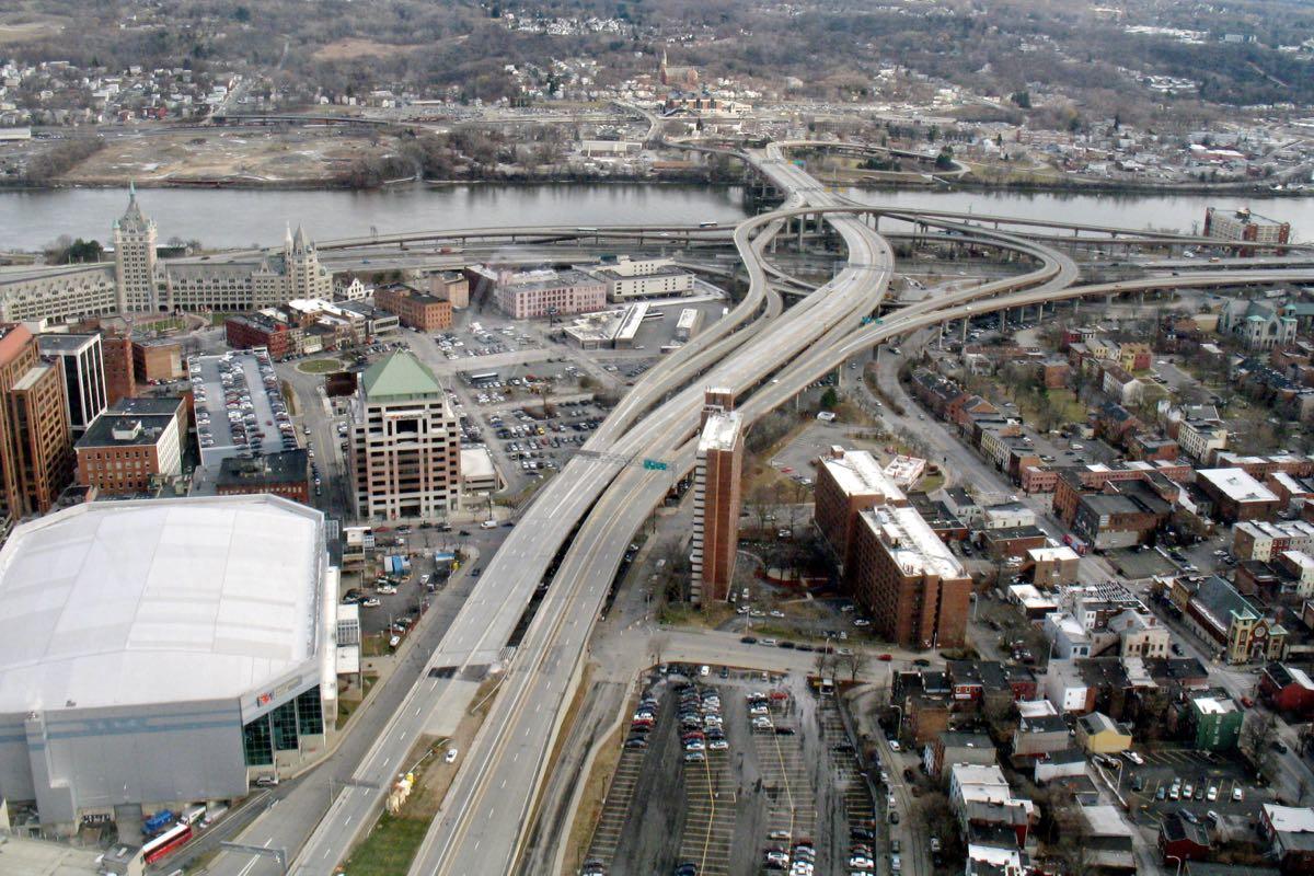
Let's just get right to the point most people want to hear about: The new draft of the I-787/Hudson Waterfront Corridor Study doesn't lay out a detailed plan for making the sort of radical changes to the highway that so many people have desired for so long.
But the long-awaited report -- the product of a process that stretches back to 2014 -- does provide an extended outline of possibilities for potentially making over one of the Capital Region's key pieces of infrastructure and the Hudson River waterfront.
"We have options, what we need is a champion, we need support, we need funding to go to the next step," said Capital District Transportation Committee executive director Mike Franchini this week at an open house for the project at the Albany Public Library. CDTC headed up the report in collaboration with the state Department of Transportation, the city of Albany, and a team of consultants. "And that's really going to depend on the public and the municipalities in the area whether they want to go there or not."
Here's a big overview of what's in the report, along with a few thoughts for the future...
Ideas for the Albany Skyway
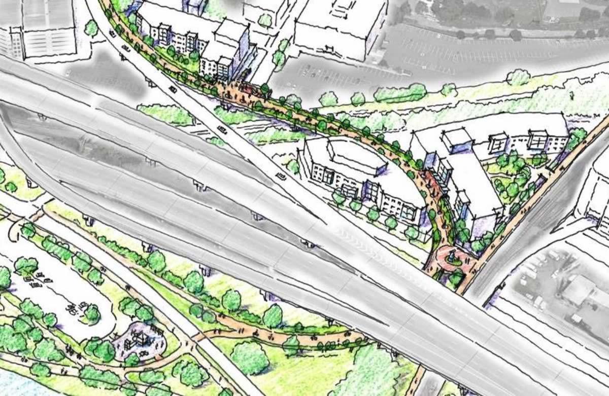
One rendering of one possible version of the project.
Three million dollars has a way of changing people's perspective of what's possible.
The idea behind the Albany Skyway -- to convert a lightly-used off-ramp from I-787 to Clinton Ave in Albany into a connection between Broadway and the riverfront -- first popped up in plans for the Corning Preserve and downtown four years ago. It was, as mayor Kathy Sheehan said at a public planning meeting Thursday evening, a "sort of pie in the sky, almost dream" idea.
The almost dream is now almost reality thanks in large part to $3.1 million in funding the Cuomo administration announced for the project this week, a surprise boost that now has the planning moving forward.
"We're in a unique position of starting off on a planning exercise that ... doesn't have have us going out at the end of the day and hoping to make this project a reality," Sarah Reginelli told the crowd. She's the president of Capitalize Albany, which has been heading up the planning. "This project will be a realty."
So that's what members of the public, along with all sorts of officials, got together to talk about.
Here are a bunch of bits about what people said they'd like to see happen, along with a few thoughts about this project.
Whatever happened to that study about the future of the I-787 corridor?
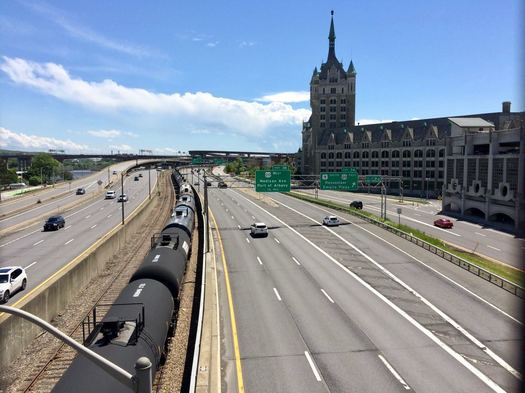
Back in 2015 there was a series of public meetings to kick off the I-787/Hudson Waterfront Corridor Study, a project intended to help plot the future of 787 from the Port of Albany north to Watervliet. The study got a lot attention because many people saw it as the first step in moving toward knocking the elevated portion of the highway.
Two years later the study is still not out. So what's up?
"It is a highway, it is asphalt and concrete, we get a shovel and we hit it enough times it cracks up ... put it in a truck and there is no more highway."
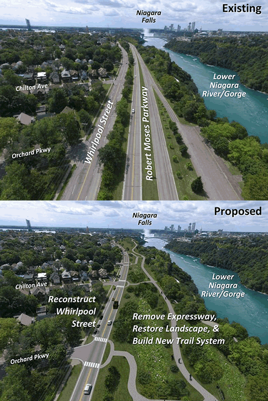
The Cuomo admin released these images for the project today (we gif'ed them). Here are more, and larger, images.
Farther afield, but maybe of note because of the ongoing 787 discussion: The Cuomo admin announced today it's directing $42 million toward ripping out a two-mile section of the Robert Moses Parkway along the Niagara River and gorge in Niagara Falls. The project will include reconstruction of a parallel street, along with new bike trails and green space. Local representatives have been pushing for the highway's removal for years. [Cuomo admin] [Buffalo News]
There are a lot of differences between the Robert Moses Parkway and 787 -- including scale. The parkway carries not quite 3200 vehicles a day, according traffic volume estimates. The segment of 787 just north of the South Mall Expressway carries almost 46,000 vehicles.
But if you're a tear-down-787 person, some of the remarks Andrew Cuomo made today might make your ears perk up.
The South Mall Expressway set for a rehab
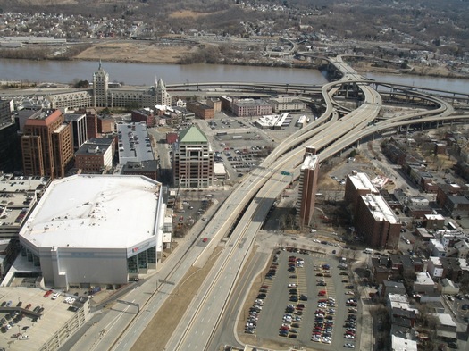
The South Mall Expressway viewed from the Corning Tower
The Cuomo admin announced this week that $22.4 million will be spent rehabbing the South Mall Expressway, which connects I-787 to the Empire State Plaza. Work is scheduled to start later this month.
Press release blurbage:
Work on the South Mall Expressway, which carries approximately 21,000 vehicles each day, will occur from I-787 to inside the tunnels underneath the Empire State Plaza. The project will include replacing the concrete driving surface of the four bridges that carry the expressway over 787 and city streets. Work will also involve structural repairs to the bridges, including joint and bearing replacements. Repairs to the pavement leading into the tunnel, work on the connecting ramps and bridge painting and steel repairs are also included in this project.
The project is scheduled to happen in stages -- the westbound side (toward the ESP) this year, the eastbound side (toward 787) next year, and then work under the bridge in 2018. Also: "Consistent with Governor Cuomo's Driver's First initiative, the project has been designed to minimize impacts to expressway traffic. Work that will most affect travel lanes has been scheduled for summer months, when traffic volumes are lower."
He's never going to leave her
The future of 787 is always a hot topic because a lot of people see the highway's placement and shape as a barrier -- between Albany and the riverfront, between downtown Albany and the South End. And if you compare aerial photos of Albany pre-South Mall Expressway and after, you can see the huge path the road plowed through downtown.
What if tearing down I-787 could actually improve traffic?

The future of I-787 often pops up in conversations about downtown Albany - specifically, the desire that many people apparently have to see the elevated highway torn down.
There's a currently a longterm effort by a group of state and local agencies to study this overall topic. And you're probably already familiar with some of the potential benefits the tear-it-down crowd touts: A boulevard replacement would reconnect the city with the waterfront. It could improve air quality, especially in some underprivileged areas. And it could open up considerable portions of land for development.
Of course, one of the counter arguments is that 787 is necessary to handle the large amounts of traffic that flow into Albany each weekday, and tearing it down would tip downtown into traffic gridlock.
But what if it was just the opposite -- what if tearing down 787 could actually make traffic in Albany flow more smoothly and efficiently?
Four takeaways from the kickoff for the study about the future of I-787
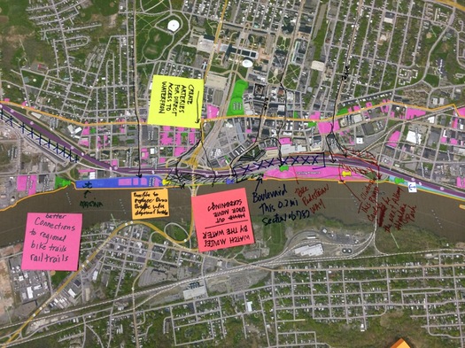
A large map was laid out so members of the public could annotate with ideas.
The planning project for the future of I-787 -- and the waterfront -- got off to its public start Wednesday with presentations at the Albany Public Library.
The I-787/Hudson Waterfront Corridor Study is sponsored by Capital District Transportation Committee, the state Department of Transportation, and the city of Albany. Its focus extends from the Port of Albany along the riverfront north to Watervliet. And its aims include helping develop strategies for improving waterfront access and guiding future transportation planning.
We stopped by for the early presentation (the same presentation was to be repeated in the evening), and took some time to check out the various posters and other "visioning" materials.
Here are four impressions/takeaways...
Workshops on the future of I-787
The planning project for the future of I-787 -- and the waterfront -- has a pair of public workshops lined up for later this month. As the flyer for the events says: "Help Us Visualize the Future of the Corridor."
Expanded blurbage:
Join us at one of two public workshops on June 24th in Albany or June 30th in Watervliet to discuss the future of the I-787/waterfront corridor. The purpose of the workshops is to introduce the study and its objectives, to share information on existing land uses and the transportation system and to provide opportunities for input on short and long term transportation and land use strategies.
Along with a brief presentation, workshop attendees will be able to view study area maps and data, can offer initial input on strategy and evaluation criteria and can participate in a hands on "map your ideas" station.
The first workshop is June 24 at the Albany Public Library main branch on Washington Ave from 4-7:30 pm (with presentations at 4:30 pm and 6:30 pm).
The second workshop is June 30 at the Watervliet Senior Citizen Center (1541 Broadway) from 5-7:30 pm (presentation at 5:30 pm).
The I-787/Hudson Waterfront Corridor Study is sponsored by Capital District Transportation Committee, the state Department of Transportation, and the city of Albany. Its focus extends from the Port of Albany along the riverfront north to Watervliet. And its aims include helping develop strategies for improving waterfront access and guiding future transportation planning.
Whenever we ask people here at AOA about things they'd like to see changed about area, 787 gets mentioned. A lot. So this could be a good opportunity to get your concerns and ideas on the record with planners.
Furthermore: A lot of cities have been facing the issue of what to do with their urban (often elevated or waterfront) highways. Just down the Thruway, Syracuse has been trying to sort out what to do with I-81, an elevated highway that runs right through the middle of downtown, a process that's included conflict between the city and its suburbs. (Here's the latest on the I-81 storyline.)
As part of the planning process for the next I-81, the Syracuse Metropolitan Transportation Council put together a bunch of case studies about how other cities have handled remaking urban highways -- it's worth a look if you're interested in the topic.
South End Bikeway Link
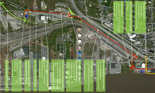
Here's an interesting idea: The South End Bikeway Link -- a proposal to connect Albany County Helderberg-Hudson Rail Trail with the Mohawk-Hudson Bike-Hike Trail and Albany waterfront.
A coalition of local bike, rail trail, and neighborhood group is supporting the idea. And there's a public meeting this evening (Wednesday) at the Albany Public Library main branch at 6 pm to share info and rally support.
Press release blurbage:
The proposed bike link would extend the existing Mohawk-Hudson Bike-Hike Trail further south and tie into the new Albany County Helderberg-Hudson Rail Trail. This much-anticipated "Rails to Trails" route will stretch 9.3 scenic miles to the Village of Voorheesville from the South End. The link will be wildly popular with bicyclists, runners, and walkers when the final Bethlehem-South Albany segment opens in late October 2015.
The Atlantic: The future of urban highways is playing out in upstate New York
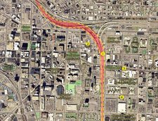 Over at The Atlantic Cities today there's a good overview of the situation surrounding the impending replacement of I-81 in Syracuse, which runs right through the heart of the Salt City's downtown. The situation will probably sound very familiar to anyone who's thought about the future of I-787 in Albany. A clip:
City leaders like Robinson, along with downtown developers and advocates for smart growth, would like to see I-81 rerouted around Syracuse and replaced with a landscaped boulevard. But suburban business-owners and many of the 45,000 drivers who use the highway to commute fear that any change could hurt the local economy. It's a debate that goes beyond the immediate question of how Syracuse workers will get to work -- to what kind of city Syracuse will be in the 21st century.
Similar discussions are happening across the United States, says John Norquist, president of the Chicago-based Congress for the New Urbanism, which publishes an occasional list of interstates ripe for demolition. Many urban freeways -- a staple of mid-20th century car-centric development -- are beginning to fall apart, and today cities from New Haven to Seattle (not to mention others around the world) are taking the dramatic step of tearing them down. A former Milwaukee mayor, Norquist oversaw the conversion of an elevated highway to a boulevard there in 2002, following a model pioneered by Portland in 1978 and San Francisco in 1991.
"It's starting to happen all over the place, and there's a reason for it," says Norquist. "Freeways don't add value to cities. They're all about one dimension, which is just moving traffic. It's a rural form, visited upon the city, that destroys property values, commerce and vitality."
The article, by Amy Crawford, is a good overview because it captures many of the tensions of the situation -- between city and suburbs, between walkable and automobile infrastructure, between local and state decision making. And, oh yeah, cost.
As that clip mention, the thing about these elevated highways, 787 included, is that they eventually will reach the end of their lives -- because they will be literally falling apart. That will mean hard choices -- and maybe also big opportunities.
[via @rachbarnhart]
Earlier:
+ In another upstate city, a discussion about an urban highway
+ "The Life and Death of Urban Highways"
+ The Albany 2030 plan included a goal of evaluating possible alternative designs for 787
+ The Stakeholders org released a report in 2011 that imagines the Albany waterfront with a boulevard
map: I-81 Challenge
I-787 construction in downtown Albany
The $20.8 million reconstruction of part of I-787 in downtown Albany (between exits 3B and 4) officially started today. (It actually started last week -- you might have noticed the lane closure on the northbound side). From the NYSDOT press release:
The I-787 rehabilitation project will include replacing the concrete driving surface, along with bridge bearings and joints, and rehabilitating the Clinton Avenue interchange ramps. The project will make the bridges along this stretch of interstate safer and provide a smoother driving surface for motorists. Quay Street and Water Street also will be paved as part of the project. ...
This year's I-787 work, focusing on the northbound lanes, began last week with a left lane closure. The lane is expected to be closed until early June. From June to September the right lane of I-787 northbound and the ramp from Clinton Avenue to I-787 northbound will be closed. The project is expected to wrap up for the season in November.
Also: "Significant traffic delays are expected, especially during the afternoon peak commuting hours of 4 p.m. and 6 p.m."
The southbound side will get attention next summer. Projected completion: fall 2013.
Earlier on AOA: "The Life and Death of Urban Highways"
... said KGB about Drawing: What's something that brought you joy this year?