Items tagged with 'weather'
The probability of a white Christmas
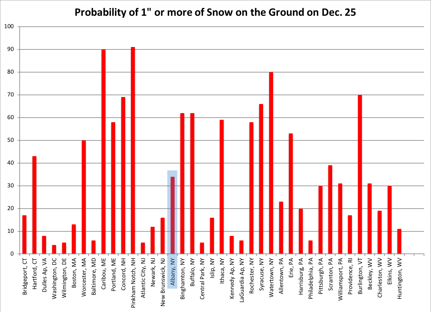
This is a NRCC graph of white Christmas probabilities for Northeast cities. We've modified it highlight Albany. (Here's a larger version.)
Weather nerding (holiday edition): On average, Albany has snow on the ground for every third Christmas.
That's from a Northeast Regional Climate Center analysis of records for the past 50 years. It looked at a bunch of cities around the nation and the Northeast to see how many Christmases in each place had at least one inch snow on the ground. In Albany case's it was 34 percent of the time.
As you might expect, some of the Upstate cities to the west have much higher probabilities. Syracuse is 2/3 (surprised it wasn't higher), Buffalo is 6/10, and Watertown is 8/10.
Last year Albany got 5.5 inches of snow on Christmas.
Earlier
+ Here's when the seasons really start and end in the Albany area*
+ Albany winters have been getting warmer
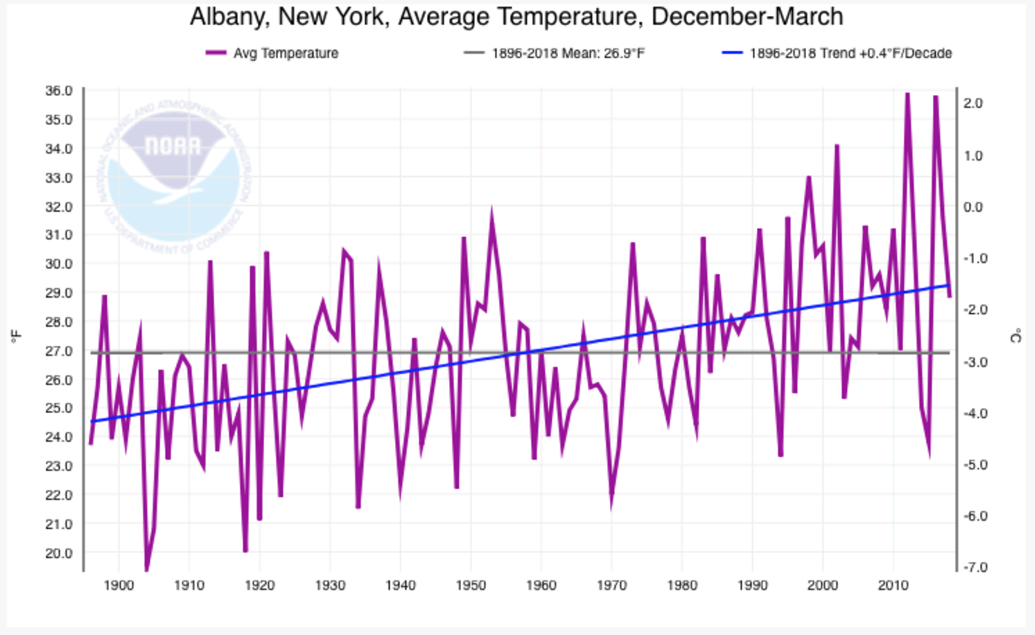
Albany winters have been getting warmer
Here's a larger version.
A lot of people seemed to enjoy last week's post about when it's "actually" winter here -- that is, the part of the year here that tends to have the coldest temperatures rather than the standard definitions of the season. We looked at it two ways, and the best way (in our opinion) pegged winter in the Albany area as being from December 1 to March 20.
So here's the B side to that track: On average, winters in the Albany area have been getting warmer over the last century (plus). And not by a little -- the average December-March temperature here has been trending up by .4 degrees Fahrenheit per decade.*
That graph above was generated by an interactive tool on the website for NOAA, the federal agency. It shows the trend for average December-March temperatures in Albany between 1896 and 2018.
Here are a few more bits.
Here's when the seasons really start and end in the Albany area*
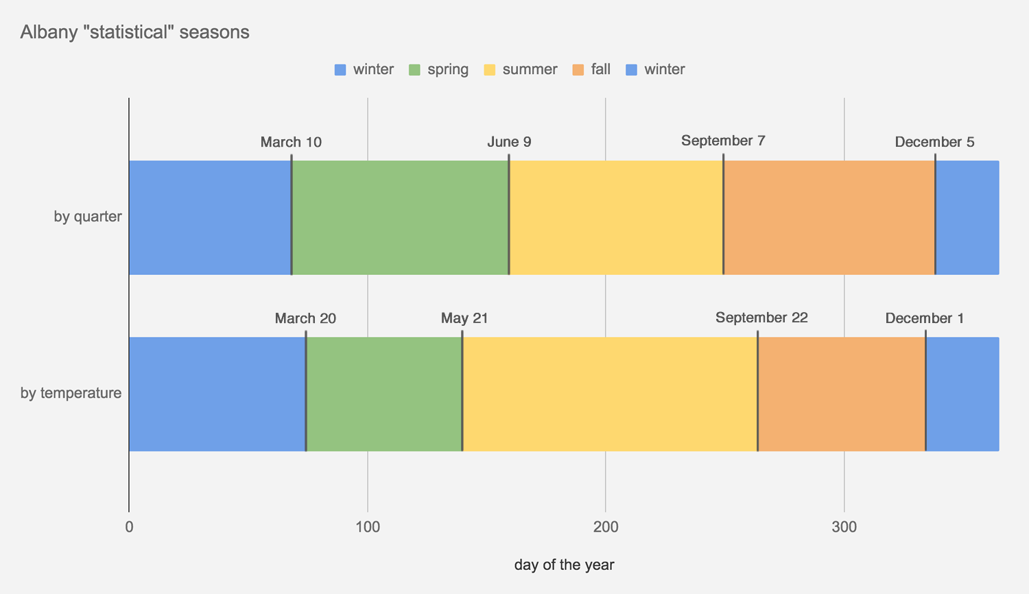
* On average. And by these definitions, which are just one or two ways of looking at this topic. Really, it's winter whenever you decide to switch to the big coat and put the shovel in the car. | Also: Here's a larger, easier-to-read version of this graph.
Winter starts December 21 -- by the astronomical definition. And it starts December 1 by -- the meteorological definition.
But when does it really start in Albany?
Inspired by a chart and discussion on Twitter today attempting to mark the start of seasons in various places around the country based on normal temperatures, we figured it'd be interesting to look at the daily temperatures in Albany in order to define what you might call the "statistical" seasons. That is, when the seasons start based on what the temperatures actually are and not what the calendar says.
Of course, you can interpret numbers all sorts of ways. And in this case we ended up doing it two ways:
+ Breaking the year up into (roughly) four quarters according to normal temperatures. Winter's the coldest 25 percent of the days each year, summer's the warmest 25 percent, and spring and fall are what's in between. Looking at it this way, winter starts December 5 and lasts until March 10.
+ Looking at the distribution of temperatures here throughout the year and defining winter and summer as the days when temperatures are either in the bottom or top 25 percent of the distribution. Spring and fall are everything in between. Looking at it this way, winter starts December 1 and lasts until March 20.
And: See resulting chartage above. Don't worry, we've included a larger version here, along with a bonus graph.
Here's a bit more explanation and weather nerding...
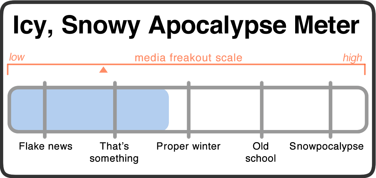
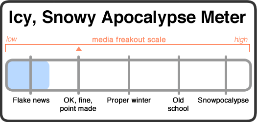
Icy, Snowy Apocalypse Watch (updated)

Updated Thursday afternoon. The forecast for snow totals continues to climb. And there's now a winter storm warning in effect.
Don't call it a comeback. Winter's been here for years.
It's mid November and we're pulling the Icy, Snowy Apocalypse Meter out of the barn for the start of the season. Let's go.
The paraphrased forecast for the next few days:
Wednesday night: Unseasonably cold. Lows around 15.
Thursday: Cloudy, with snow starting late in the afternoon. Around 32.
Thursday night: Snow and sleet. Maybe 5-9 inches. Lows in the upper 20s.
Friday: A shift to snow and rain, maybe freezing rain, and then rain. Highs in the upper 30s.
The updated forecasts for this particular apocalypse keep increasing the predicted snowfall. And the totals are now looking like winter's going to do some work. The National Weather Service Albany probabilistic snowfall forecast has Albany pegged for about 9 inches of snow. And the various probabilities for snowfall ranges point to a ceiling below 12 inches..
The Friday morning commute looks it won't be fun. There's still the issue of potential sleet and freezing rain. And it sounds like this will be wet, heavy snow (which is the worst kind of snow -- take it slow when shoveling).
So we're upgrading this icy, snowy apocalypse to "proper winter" level.
Shovels at the ready -- you are all hardy Upstaters.
Media freakout forecast: Early season. Remember to stretch. It's been a while.
Necessary note: You should take this all with an enormous bag of rock salt. AOA has absolutely no weather forecasting expertise. At all. That said, the world will probably not end because of some snow. Most likely.
Those odd clouds, and a handful of rainbow pics
Follows by some odd clouds pic.twitter.com/cWWH5LZLDA
— Basil Seggos (@BasilSeggos) October 23, 2018
Tuesday's late afternoon thunderstorm created some fantastic rainbows around the area. And while you were gawking at the prismatic display, you might have also noticed some odd-looking clouds -- a sort of formation we don't see very often around here.
It caused local weather nerds to have a moment. See this thread over on the National Weather Service Albany Facebook page in which people shared all sorts of photos.
Here's a quick overview of what exactly those were, and a bunch of bonus rainbow pics...
It's looking like it could be a relatively warm winter. Probably.
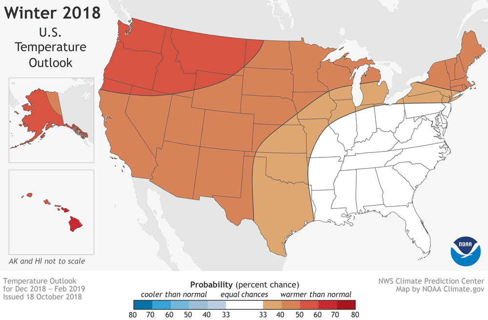
The map represents three ranges of outcomes: cooler than normal (blue), normal (white), and warmer than normal (orange). / image: NOAA
The federal government's Climate Prediction Center released its outlook for the upcoming winter in the United States today and it's pointing to a relatively warmer winter in this part of the country. Overview blurbage:
A mild winter could be in store for much of the United States this winter according to NOAA's Climate Prediction Center. In the U.S. Winter Outlook for December through February, above-average temperatures are most likely across the northern and western U.S., Alaska and Hawaii.
Additionally, El Nino has a 70 to 75 percent chance of developing. "We expect El Nino to be in place in late fall to early winter," said Mike Halpert, deputy director of NOAA's Climate Prediction Center. "Although a weak El Nino is expected, it may still influence the winter season by bringing wetter conditions across the southern United States, and warmer, drier conditions to parts of the North."
The outlook pegs Upstate in the "equal chance" category for a drier or wetter winter.
Here's a quick video that walks through the outlook and includes an explanation for the prediction maps.
Noted: "[T]he outlook does not project seasonal snowfall accumulations. Snow forecasts are generally not predictable more than a week in advance. Even during a warmer-than-average winter, periods of cold temperatures and snowfall are still likely to occur." As you well know, all it takes is for a few Nor'easters to track toward the coast and we can end up with feet of snow.
Last winter
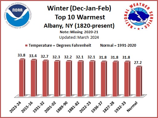
The Climate Prediction Center outlook for the previous winter pegged the odds being in favor of a warmer than normal winter for this part of the country. And that's how it ended up: The average temperature for the last meteorological winter -- December, January, February -- was 1.3 degrees warmer than the normal (31.4 degrees).
By the way: Four of the warmest winters on record for Albany -- that is, since 1820 -- have occurred since 2000. And 2015-16 is the warmest on record.
Yep, this summer was unusually hot
This summer also had a high melted-ice cream index.
Summer ends this weekend.* And it's been hot -- unusually so, by a few measures.
One of those is 90+ degree days. The Albany area has logged 20 90+ degree days this year (so far) between May and September.** And while that's not close to the record, it is a high enough number to be tied for 10th all time.
Those numbers are from the National Weather Service Albany and the records go back to 1874.
Because we can't help ourselves, here's a graph and a few more bits...
Rain in the ground
One important capability of the #NYSMesonet is its ability to measure not just rainfall but soil moisture, which is critical when it comes to assessing the risk of potentially dangerous flooding. A 2-week animation of soil moisture (below) tells the story! https://t.co/aElRMj89Rh pic.twitter.com/eggHUVcmjh
— NYS Mesonet (@nysmesonet) July 25, 2018
A map + weather nerding = sold.
The NYS Mesonet is a network of more than 120 weather stations around the state that's based at UAlbany. One of its goals is provide better info for weather predictions.
2.45 inches of rain
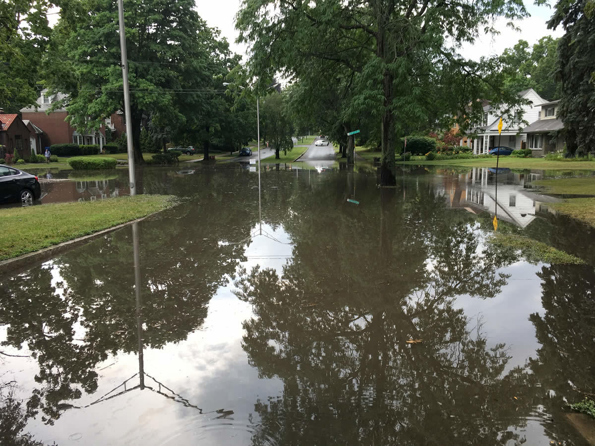
The thunderstorm that tracked over the western portion of city of Albany dropped 2.45 inches of rain in less than an hour, according to a report received by the National Weather Service Albany. (Update: NWS Albany said another backyard rain gauge recorded 4.9 inches.)
And that led to a bunch of flash flooding scenes like the one above at Manning Boulevard and Myrtle. See also: Western Ave and Colvin Ave (Olivers Brew Crew looked like an indoor wading pool). [@jamesbelflower] [@CBS6Heather] [Olivers Brew Crew Facebook]
We were curious how often a rainfall like this occurs. NWS Albany responded via Twitter that it's a few-times-a-decade occurrence in the city of Albany.
(Thanks for the pic, G.)
Earlier: Adapting for a more extreme future
The recipe for a thunderstorm

You no doubt know Jason from his many years as a meteorologist on TV here in the Capital Region. He's helping us nerd out on some local weather stuff. Got a question about how local weather works? Send it along!
I was an on-air meteorologist for 17+ years and during that time I visited over 200 schools to give weather talks. The most frequently asked question was: "Why/how did you get in to meteorology?"
The answer is simple: thunderstorms.
Damn things used to freak me out, especially at night. You're like six years old, the whole room lights up and then, BOOM. No, thank you. Didn't want any part of that mess.
But one day my father took me down to the main branch of the Albany Public Library to learn about thunderstorms, and that's exactly what I did. I quickly found out how simply amazing thunderstorms are. And by the way, so is the rest of our weather.
I was hooked, and always will be.
Here's how much it snowed in various places all around New York State this winter
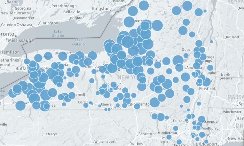
There's a clickable map, too. (Because of course there is.)
May starts this week, so that probably means we're finished with snow for the season. Though April apparently decided to get a few more flakes in before exiting.
So to bid a final farewell to this past winter, here's a clickable map of snow totals from around New York State for the season. Some of them are bonkers.
By the way: Wednesday and Thursday this week both have forecasted highs in the 80s.
So, let's talk about the weather this spring
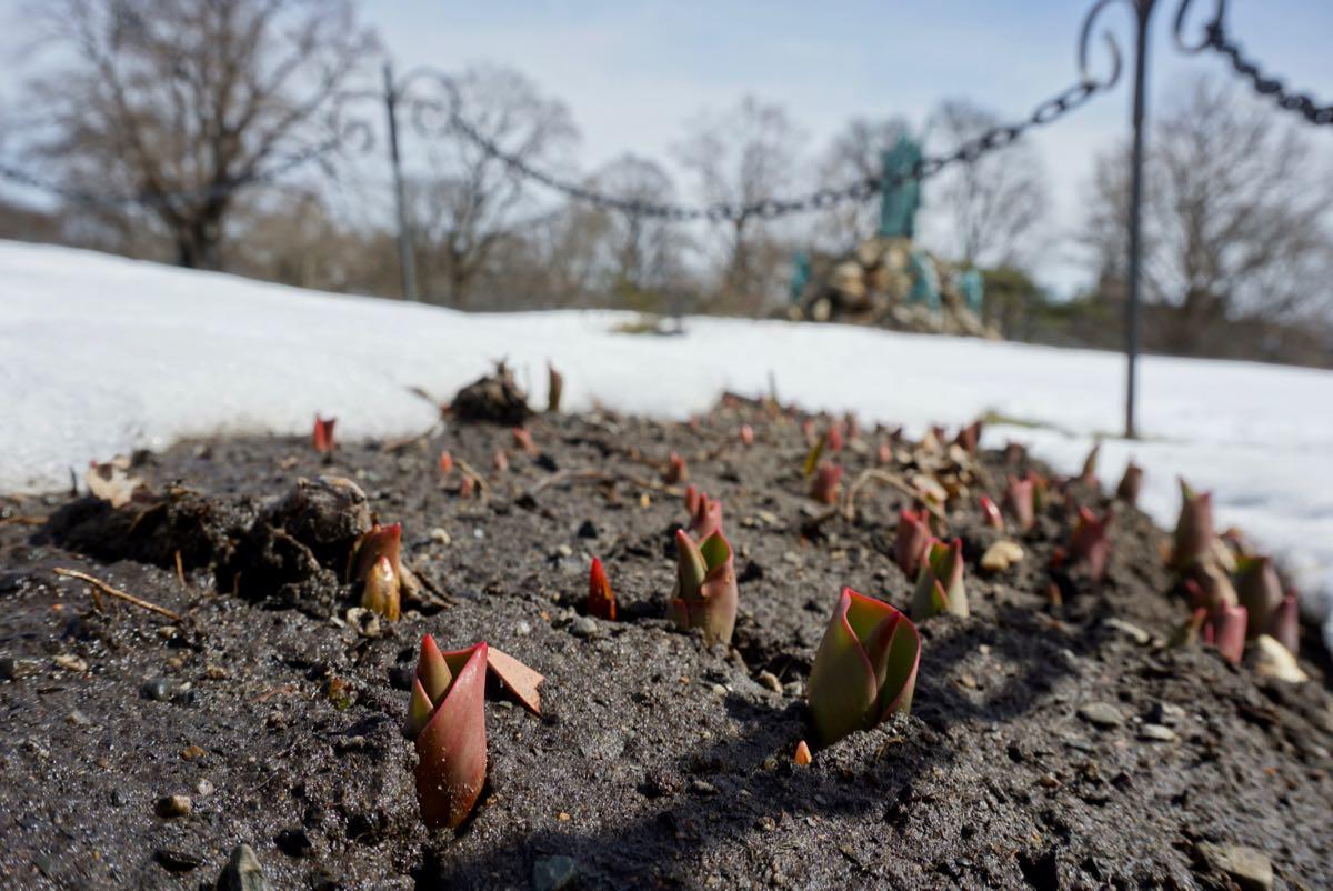
The tulips got a slow start this spring.
You no doubt know Jason from his many years as a meteorologist on TV here in the Capital Region. He's helping us nerd out on some local weather stuff. Got a question about how local weather works? Send it along!
"WHAT THE HELL'S GOING ON OUT HERE!!" - Vince Lombardi
"Spring, my dimpled tookus". - Jason Gough
OK, we know this spring is the pits, but just how many pits are we talking here?
Before we take a look at some hard numbers to right the ship of despair that is spring 2018, let's look at the bigger picture.
Nor'easters and model behavior
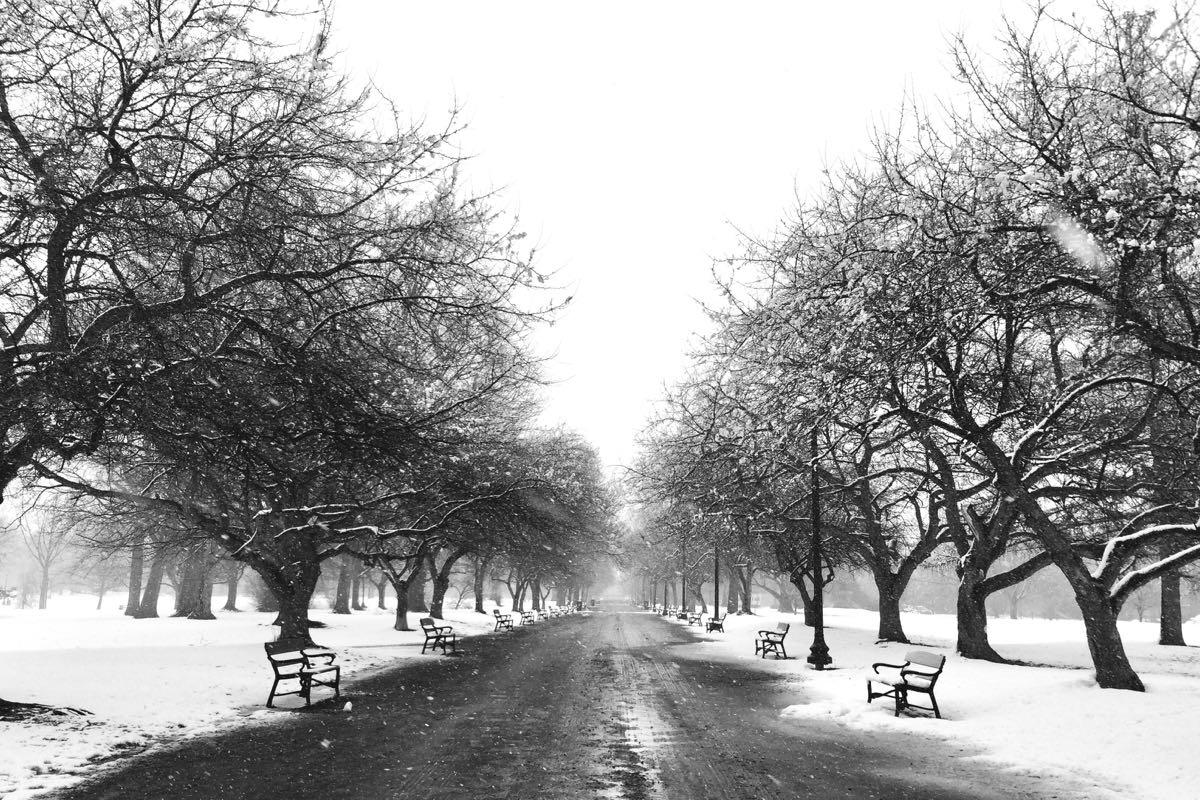
March was just... very gray.
We're happy to welcome Jason Gough to AOA as a contributor. You no doubt know Jason from his many years as a meteorologist on TV here in the Capital Region. He's helping us nerd out on some local weather stuff. Got a question about how local weather works? Send it along!
Last time we spoke it was about "the models," the complex sets of atmospheric models meteorologists use to make predictions about the weather -- some of the history behind them, what goes into them, what makes them imperfect. And I promised at the end we'd get to how we use those models to make a final forecast and the ongoing competition between the Americans and Europeans.
Since that time, well, it's not been the best March in recent memory. Our highest temperature of the month was 56 degrees, and that was on the last day of the month. We also had our share of snow -- enough to make into the top 10 of snowiest Marches on record. That snow was not easily forecasted. And it piled up. A few times.
So let's starting off talk about the first Nor'easter of the month and the forecasts for it.
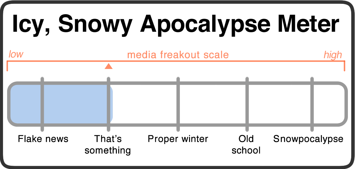
Icy, Snowy Apocalypse Watch
Spring is out there. Somewhere. Probably.
The paraphrased forecast for the next few days:
Monday: Thoughts of crocuses and daffodils. Highs in the upper 30s.
Monday night: Memories of the feel of sun-warmed earth. Snow, at least a few inches. Lows around 30.
Tuesday: Thoughts of crunchy snap peas. More snow, probably another few inches. Mid 30s.
Tuesday night: Recollections of tulips. Probably more snow. Upper 20s.
Wednesday: A watch for more robins. Maybe more snow. Mid 30s.
So another storm is making its way up the East Coast week. Yep, how about that. It's looking like the worst of it will probably be to the east. The THE PROBABILISTIC SNOWFALL FORECAST MAPS have the "expected snowfall" for the Capital Region core pegged at 4-6 inches. And a snowfall of greater than 8 inches is forecasted to have a less-than-20-percent chance.
That all said... and as you well know... a small change in the track of a coastal storm can make a big difference in how much snow we get.
Even so, we're marking this Icy, Snowy Apocalypse Watch as just into "that's something" territory. It sounds like the morning commute on Tuesday could be snowy. But otherwise... six inches, fine, OK, yep.
Shovels at the ready, hardy upstaters. Look forward to spring.
Media freakout forecast: March madness. We're on the brink of having one of the 10 snowiest Marches on record.
Necessary note: You should take this all with an enormous bag of rock salt. AOA has absolutely no weather forecasting expertise. At all. That said, the world will probably not end because of some snow. Most likely.
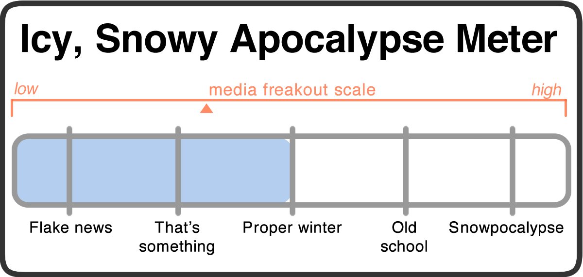
Icy, Snowy Apocalypse Watch (updated)
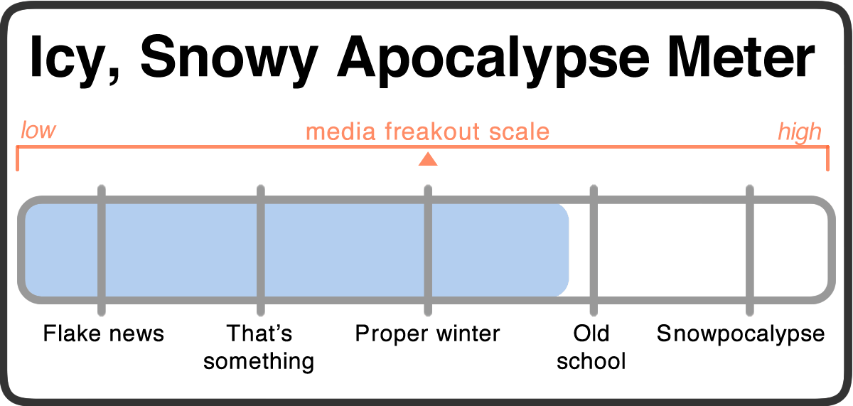
Updated Wednesday at 8:30 am: After yesterday's upward revision on the snowfall totals, it looks like the bulk of the snowfall has now shifted to the afternoon, though the projections for total snowfall are about the same. But, you know, every icy, snowy apocalypse is like its own snowflake.
The Icy, Snowy Apocalypse Watch is having a deja vu moment.
The paraphrased forecast for the next few days:
Tuesday: Sunny. Mid 40s. La la la.
Tuesday night: Maybe snow starting after 11 pm. Lows in the upper 20s.
Wednesday: Snow. Snow. Snow. Maybe 3-7 inches. Mid 30s.
Wednesday night: Snow. Snow. Snow. Maybe another 3-7 inches. Lows around 30.
Thursday: Probably more snow in the morning, mid 30s.
Thursday night: Maybe more snow, lows in the upper 20s.
Friday: Maybe some snow, maybe rain. Mid 30s.
Unlike last week's storm, the forecasts for this week's Nor'easter are relatively confident there's going to be significant snow. In fact, the National Weather Service has already issued a winter storm warning from Wednesday morning to Thursday morning with "heavy snow expected."
Updated How much snow? Let us now turn to... wait for it... yes, it's THE PROBABILISTIC SNOWFALL FORECAST MAPS. The "expected snowfall" for Albany is now 12-18 inches with more at higher elevations. And the window of outcomes in Albany appears to be not that big:
+ >= 6 inches: 89 percent
+ >= 8 inches: 80 percent
+ >= 12 inches: 53 percent
+ >= 18 inches: 5 percent
Of course, you know about coastal storms. A small change in track can make a big difference in how much snow we get. But it's looking like there's a pretty good chance of significant snow.
So we're marking this Icy, Snowy Apocalypse Watch very much into the "proper winter" category, and nearing the old-school snow storm level. It sounds like the snow could be more on the wet side (ick), and the storm could really be cranking during the Wednesday commute home. So, yeah, that should be... interesting.
Shovels at the ready, hardy upstaters.
Media freakout forecast: We are onto you, Nor'easter!
Necessary note: You should take this all with an enormous bag of rock salt. AOA has absolutely no weather forecasting expertise. At all. That said, the world will probably not end because of some snow. Most likely.
Icy, Snowy Apocalypse Watch
How lucky are you feeling? Because the Icy, Snowy Apocalypse Watch is going to roll the dice.
The paraphrased forecast for the next few days:
Thursday: Some snow. Low 50s. What's the big deal?
Thursday night: Rain, maybe changing over to snow. Lows in the upper 30s.
Friday: Some sort of mix of snow and rain. Maybe 3 inches of snow during the day. Highs in the low 40s.
Friday night: Probably more of the snow/rain mix. Windy. Lows around 35.
Saturday: Cloudy, maybe some rain. Highs around 40.
OK, here's the important thing to know about the weather over the next day or two: No one seems to know exactly what's going to happen.
The signs are pointing to what the NWS Albany forecast discussion calls a "potent coastal storm" moving up the East Coast. Somewhere along the line it's going to meet colder air moving in from the west. It's just not clear exactly how that's all going the shake out. And you know about coastal storms -- a little shift one way or the other can make a big difference.
What's all that mean for what's going to happen here? Well, again we turn to our absolute favorite National Weather Service page: (trumpets) the probabilistic snowfall forecast maps. The "expected" snowfall forecast for the Capital Region core is 3 inches -- but the totals increase steeply to the west. Westerlo's pegged at 15 inches! And Canajoharie's tagged for 8.
Sometimes that happens, especially in the Hill Towns. But here's the part that should really catch your attention -- the probabilities for larger snowfalls in Albany:
+ >= 6 inches: 38 percent
+ >= 8 inches: 27 percent
+ >= 12 inches: 11 percent
+ >= 18 inches: 2 percent
While those (much) larger amounts aren't predicted to be the most likely -- a 6-8 inch total isn't exactly unlikely, either. And larger than that? What we're saying is, there's a chance.
So we're marking this Icy, Snowy Apocalypse Watch just short of the "proper winter" category because of the uncertainty and upper-end potential. It could end up being not much. Or it could be a lot. There's an extra ugh factor because it's probably going to be wet, heavy snow. Also: We've tasted spring and going back, even for a few days, will not be pleasant.
Shovels at the ready, hardy upstaters.
Media freakout forecast: Caveats.
Necessary note: You should take this all with an enormous bag of rock salt. AOA has absolutely no weather forecasting expertise. At all. That said, the world will probably not end because of some snow. Most likely.
Very well acquainted, too, with matters mathematical, they are the very model of a modern forecast meteorological
Sometimes the models can't agree on what the picture's going to look like.
We're happy to welcome Jason Gough to AOA as a contributor. You no doubt know Jason from his many years as a meteorologist on TV here in the Capital Region. He's going to help us nerd out on some local weather stuff. Got a question about how local weather works? Send it along!
If you watched me over the years for your weather forecasts on even a semi-regular basis -- and thank you if you did! -- you may have noticed that when winter storms came into the mix, you heard something like: "I'm tracking the storm, but the models don't agree on things just yet. Still a few days to sort it all out."
The models? What's that all about?
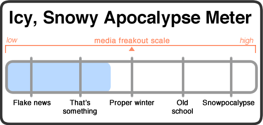
Icy, Snowy Apocalypse Watch
Timing is everything. And it's time for the Icy, Snowy Apocalypse Watch to return.
The paraphrased forecast for the next few days:
Tuesday: Maybe some snow, but not much. Cold overnight, with temps in the 10s.
Wednesday: Snow starting mid morning. Something like 5-9 inches during the day. Highs in the upper 20s.
Wednesday night: Probably more snow. Lows in the mid 10s.
Thursday: Sun, upper 20s.
The National Weather Service probabilistic snow forecast maps have the "expected" total pegged at 8 inches for much of the Capital Region core Wednesday morning to Thursday morning (with higher totals to the north). And the forecast seems pretty confident about that. The chance of more than 4 inches in Albany is figured to be 80 percent, more than 8 inches is 30 percent. And the chance of more than a foot is estimated to be 0 percent. (Apparently there's some chance we could also get some sleet.)
It seems like the big issue then is the timing of this storm. Half a foot overnight when plows can run without much traffic? Not a problem. Half a foot during the day, with snowfall cranked up around the evening commute? Ugh. (And if it's wet snow, double ugh.)
So we're marking this Icy, Snowy Apocalypse Watch just into the "proper winter" category because of the timing. Wednesday looks like it could be messy.
Shovels at the ready, hardy upstaters.
Media freakout forecast: Eh. It's February, sure, whatever.
Necessary note: You should take this all with an enormous bag of rock salt. AOA has absolutely no weather forecasting expertise. At all. That said, the world will probably not end because of some snow. Most likely.
Icy, Snowy Apocalypse Watch
Scary-sounding meteorological term. Scary-sounding meteorological term. SCARY-SOUNDING METEOROLOGICAL TERM.
Yep, it's Icy, Snowy Apocalypse Watch. The paraphrased forecast for the next few days:
Thursday: Snow throughout the day. Accumulations of as much as 4 inches around Albany. Highs in the low 20s.
Thursday night: Maybe a bit more snow. Wind picks up. Temps drop. Lows around 3 with wind chills around -15. Dangerously cold.
Friday: Windy, with some blowing snow, highs around 8. Wind chills around -16.
Friday night: Lows around -5. Wind chills around -23. Dangerously cold.
Saturday: Sun. Highs near... 2.
Sunday: Some sun. Highs near 13.
So this is the infamous "bomb cyclone" storm that the national media has been hype monkeying about. (The term is from "bomb cyclogenesis" -- you'll also often see the term "bombogenesis" in forecast discussions.) It's basically a coastal storm with a very strong low pressure system. If you listen to actual meteorologists, it's both not that uncommon and a lot like a Nor'easter.
You know about coastal storms. There's often a steep gradient in the amount of snowfall from east (more) to west (less). And that's the case here. Checkout the probabilistic snowfall maps from NWS Albany -- it's got the most likely outcome pegged at 7 inches in the Berkshires, 4 inches in Albany, and 2 inches in Canajoharie. Of course, with a steep gradient, the track of a storm can make a big difference in snowfall totals. But the high-end forecast -- which NWS pegs at a less than 10 percent chance of happening -- has Albany at 7 inches.
(By the way: We're a big fan of those probabilistic maps -- they're easy to read and convey how weather forecasts are really about a range of outcomes based on projected probabilities.)
The snow -- and it's looking like relatively fluffy snow -- probably won't be a huge issue. The bigger thing is the temperatures, because it's about to get dangerously cold overnight and through the next day or two. Like, frostbite-for-exposed-skin-in-10 minutes cold. And when it gets that cold, roads can be slick even with salt.
So we're marking this as a That's Something-Plus Icy, Snowy Apocalypse Watch because of the cold. Bundle up and keep an eye out for each other.
Shovels at the ready, remember that you are hardy upstaters.
Media freakout forecast: Warped by the terminology and the fact the coast is in for some serious snow. Also, the attention-devouring social media platform industrial complex demands hype. Must hype. Must cut through noise. Must get attention. So thirsty.
Necessary note: You should take this all with an enormous bag of rock salt. AOA has absolutely no weather forecasting expertise. At all. That said, the world will probably not end because of some snow. Most likely.
Icy, Snowy Apocalypse Watch
Is this winter ready to be a proper winter? Because it's not yet mid December and already the Icy, Snowy Apocalypse Watch is making an appearance.
The paraphrased forecast for the next few days:
Monday night: Snow starting late in the night. Lows in the mid 20s.
Tuesday: Snow to start, then a mixture of snow and rain. Accumulations of a few inches in Albany. Highs in the upper 30s.
Tuesday night: Maybe some more snow. Cold -- lows below 20.
Wednesday: A chance of snow. Earnestly cold. Highs in the low 20s.
Thursday: Sun. Highs in the mid 20s.
This snowfall has already been getting some hype, but the NWS probabilistic snowfall forecast* has the "expected" snow total for the Capital Region core on Tuesday pegged at 2-3 inches in Albany and 4-6 inches in Saratoga. And the range of projected possibilities is relatively narrow, just a few inches higher or lower on each end. It sounds like some warm air will make an appearance and hold down the totals. But, you know, things change, so there could be a shift. (Also: A few inches of wet snow can be worse than half a foot of fluff.) If anything, it looks like the cold weather following the snow could be more significant.
Drop this snow event in February and we're guessing most people who just sort of shrug. In early December, though... the gas tank on the hype blower is full and people are eager to pull the start cord.
So we're rating this icy, snowy apocalypse somewhere just north of "flake news" because it sounds like there will be snow, but this storm is getting hyped by the early season perspective.
Shovels at the ready; remember that you are hardy upstaters.
Media freakout forecast: Out of practice.
Necessary note: You should take this all with an enormous bag of rock salt. AOA has absolutely no weather forecasting expertise. At all. That said, the world will probably not end because of some snow. Most likely.
* Bookmark/fave/remember that NWS Albany page. It will be very helpful throughout the winter.
So, that wasn't a typical October
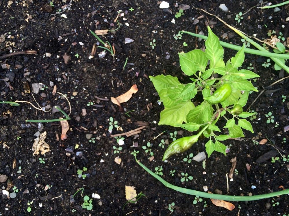
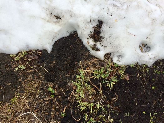
Pepper plants still growing in the garden in November? Sure, why not. They can keep the kale and brussels sprouts and onions company.
Noted: The October that just ended is now the warmest on record for Albany, according to the National Weather Service.
The average temperature for Albany during October was 57.8 degrees -- 8.1 degrees higher than the typical average. In this case, "on record" means dating back to 1820. And here are those records for October.
That follows a September that includes three days with highs above 90 degrees. (September here typically averages almost none.) And the last winter included the warmest winter day on record.
Also: The official growing season this year in Albany started April 9 and ended October 18 -- a span of 192 days. That's tied for 16th longest on record -- and the longest since 1931. (In this case, "on record" is since 1874.)
In related news: We were thinking the other day it feels like there a lot of trees around Albany that either haven't fully gotten the message about changing their leaves this year or they're conflicted about it and procrastinating.
Earlier:
+ Yep, another weird winter
+ Growing seasons in Albany
Another warm winter on the way?
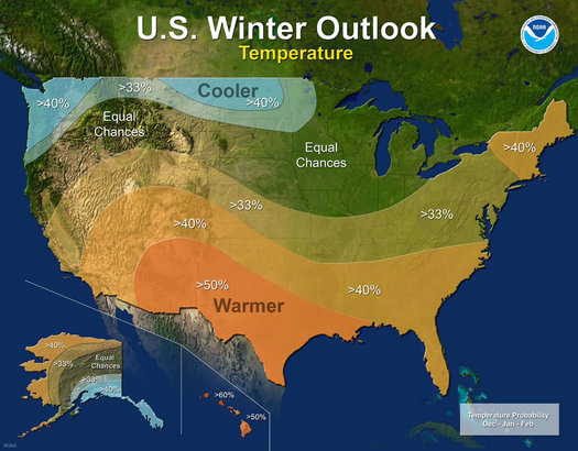
This NOAA map depicts the probabilities that temperatures will be higher or lower than normal in parts of the country.
The weather/climate forecasters at NOAA predicting that the odds favor another relatively warm winter in this part of the country. From the annual winter outlook released Thursday:
Precipitation
Wetter-than-average conditions are favored across most of the northern United States, extending from the northern Rockies, to the eastern Great Lakes, the Ohio Valley, in Hawaii and in western and northern Alaska.
Drier-than-normal conditions are most likely across the entire southern U.S.
Temperature
Warmer-than-normal conditions are most likely across the southern two-thirds of the continental U.S., along the East Coast, across Hawaii and in western and northern Alaska.
Below-average temperatures are favored along the Northern Tier of the country from Minnesota to the Pacific Northwest and in southeastern Alaska.
The rest of the country falls into the equal chance category, which means they have an equal chance for above-, near-, or below-normal temperatures and/or precipitation because there is not a strong enough climate signal in these areas to shift the odds.
In this case, "warm" is relative to a typical winter. As one of NOAA's climate forecasters told the media today, they're not necessarily predicting another crazy-warm winter like the last two. [Washington Post]
Another thing that could affect things: La Nina might develop off the Pacific coast of South America, and its effects tend to blunt the snowstorms that move up the East Coast.
Though, as we saw last year, it just takes one storm.
Earlier: Yep, another weird winter
Today's moment of summerfall
Monday's high temperature hit 91 degrees -- a new record the date. And the high Sunday was 90 degrees, another record. Near the end of September. [NWS Albany x2]
In other news: We've been eating tomatoes from the back yard like it's August.
By the way: The latest 90-degree day in a calendar year on record for Albany is October 5, set in 1941. [NWS Albany]
Also: Autumn is out there. Its temperatures approach. [@Jason_Weather]
Rainbow weather
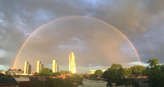
If you'd like a larger version.
We've had run of rainbow weather lately -- pop-up showers, with sun streaming in from one side and dark clouds as a backdrop on the other.
And the (double!) rainbow Sam captured arcing over the ESP this past weekend is maybe the best we've seen of the recent batch.
(Thanks, Sam!)
That's enough, March
Dearest March,
We can all agree that we live in uncertain times. So much now is odd or nonsensical, a parade of the real fake and the fake real. It's easy to feel like we're simultaneously doing too much and not enough.
So let us be clear: That's enough, March, that's enough.
... said KGB about Drawing: What's something that brought you joy this year?