Items tagged with 'transportation'
Bike share grew in both use and reach this year -- here's what CDTA's thinking about for next year
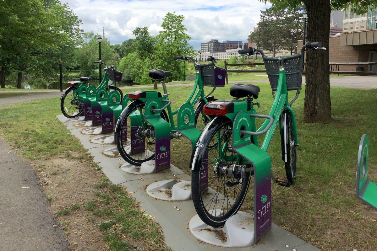
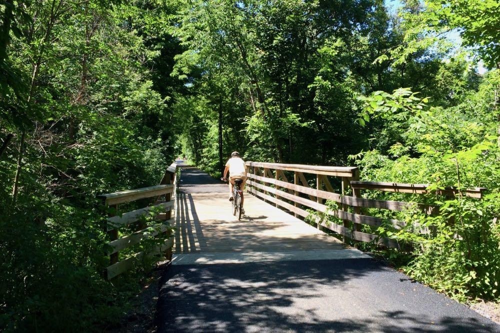
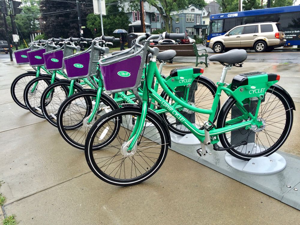
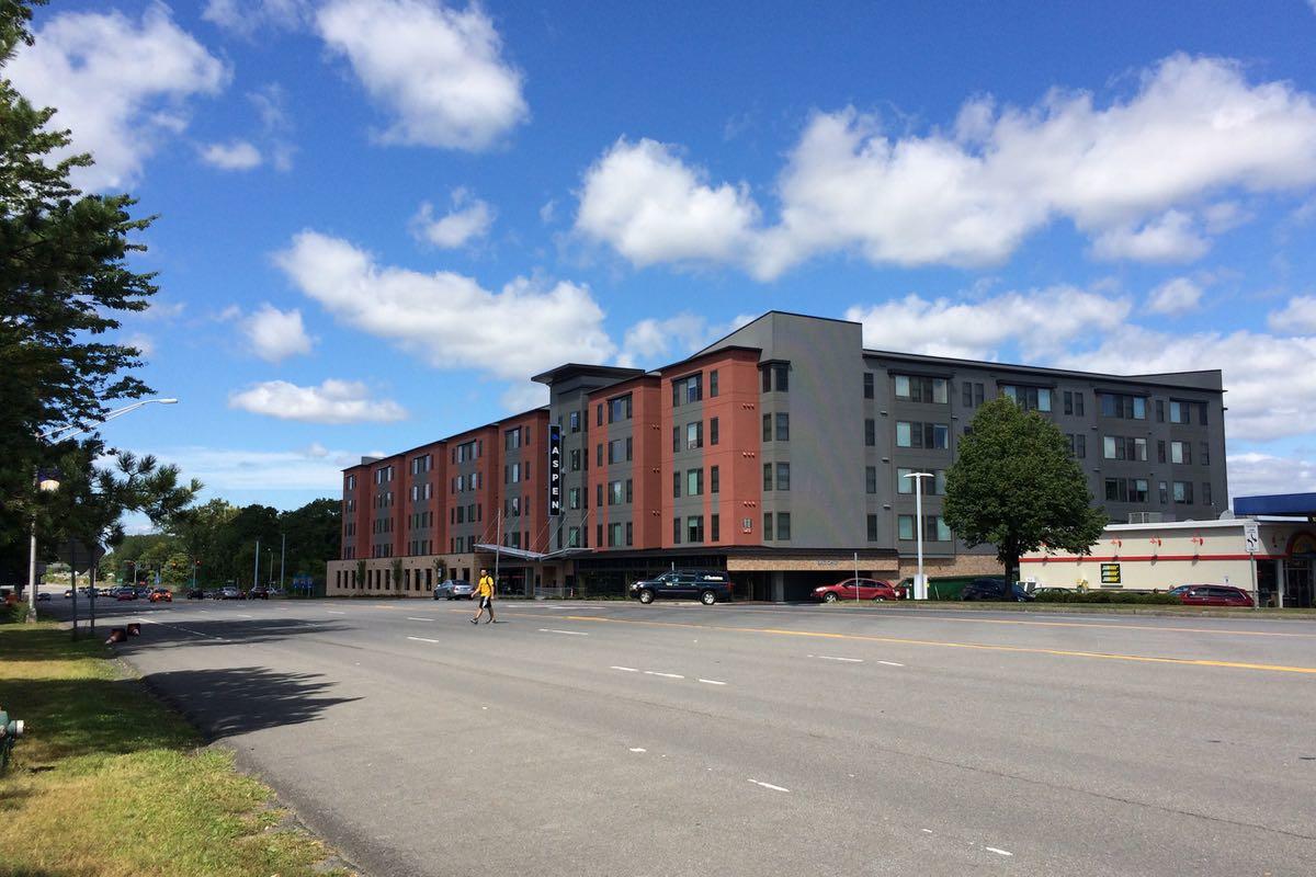
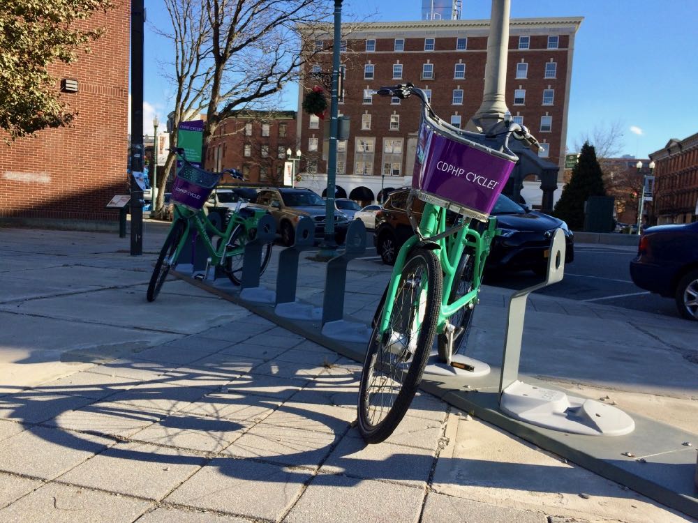
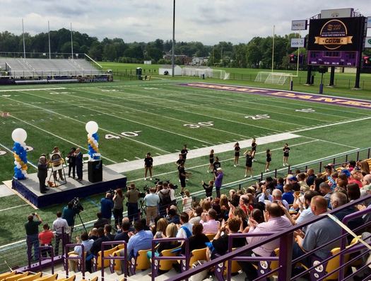
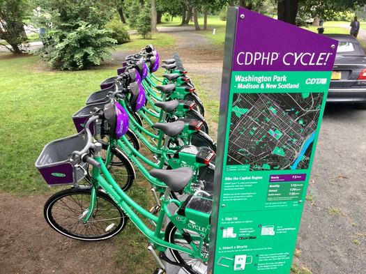
The bike share rack in Corning Riverfront Park in Albany was the most active hub in the system this past season.
The bike share run by CDTA -- CDPHP Cycle -- wrapped up its second season last week, and the transit org reported this week that people took 23,535 trips on the bikes between April and the end of November. That's more than double the total of last year's season.
CDTA pushed to expand the program this year, doubling the number of bikes to more than 300, and increasing the number of rack locations from 40 to more than 70 across larger service areas in Albany, Schenectady, Troy, and Saratoga Springs. It also managed to get more than 4,000 new members for the system, bringing the total to almost 6,600.
And here's what CDTA's thinking about for next year...
(Also: The most popular hub locations and a few other numbers.)
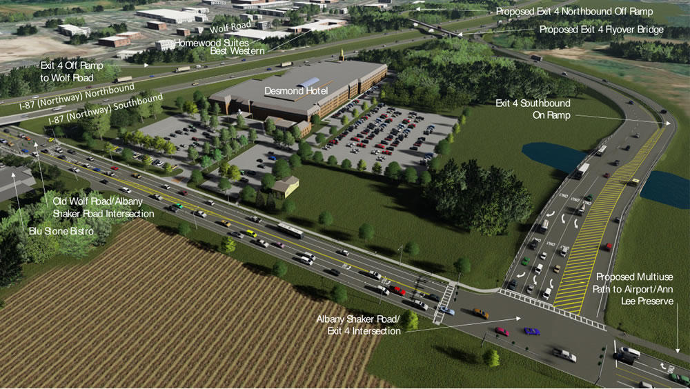
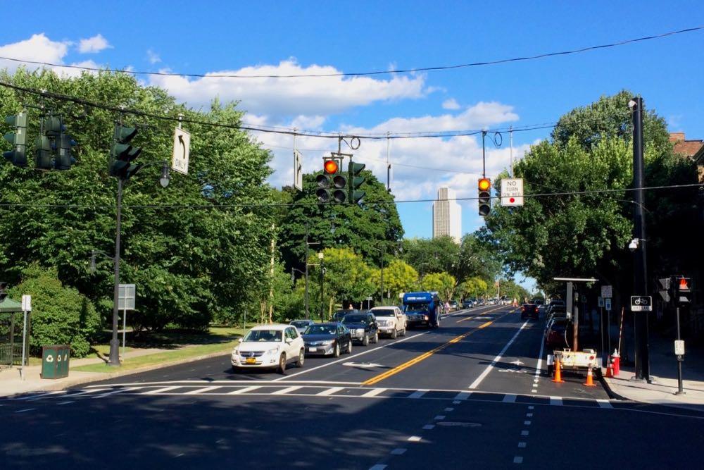
How that new connector between the Northway and ALB will work
Major construction on that new connector from the Northway for Albany International Airport is set to begin this winter, the Cuomo admin announced this week. The plan is for the $50 million exit reconfiguration to be finished by spring 2020.
That video embedded above is a Cuomo admin explainer about how the new connector ramps will work. We found it helpful in understanding the reconfiguration.
You might remember ALB is also getting a new parking garage and some makeovers, a $42 million project that's backed by $22 million from the state.
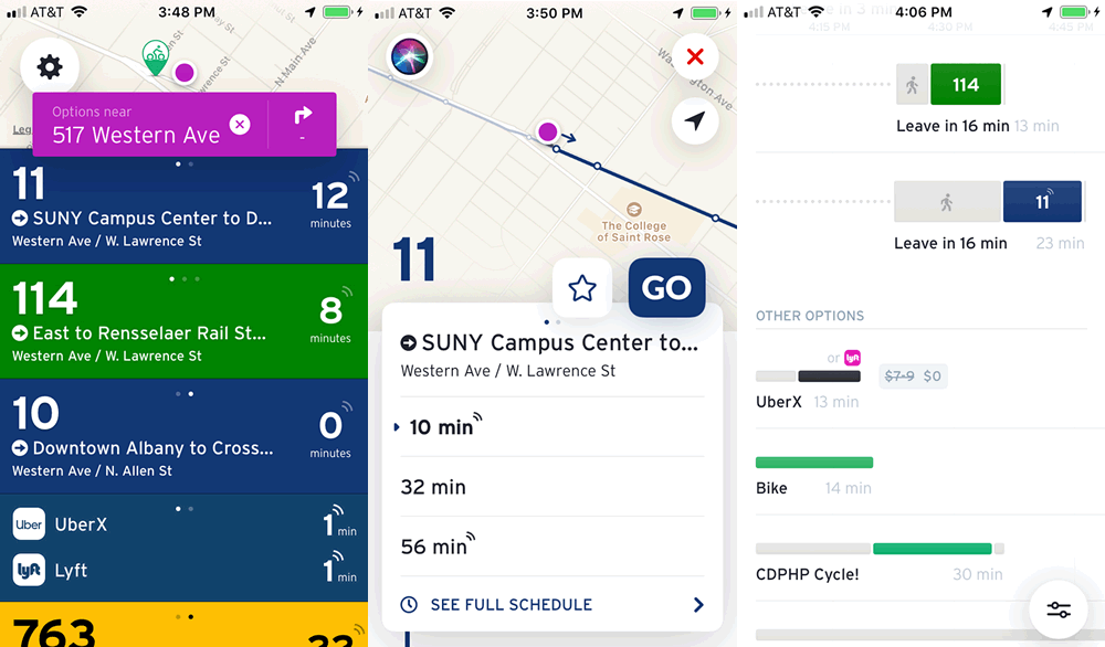
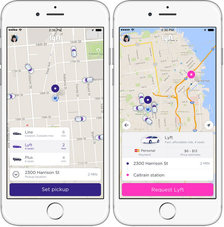
Realtime info for CDTA bus routes and ride hailing services in one place
A few screenshots.
Check it out: An app called Transit has rolled together CDTA route info with ride hailing services such as Uber and Lyft into one place.
So you can open the app and see which buses are nearby and also when you might be able to get a car via a ride hailing service and how much that might cost.
CDTA is one of a handful of transit orgs around the country that are part of the new feature. And playing around with the app today, we were surprised with how smoothly it blends together bus arrivals, Uber/Lyft rides, walking, biking, and even bike share. We might use it now instead of the CDTA app.
Albany is set to build the link between Helderberg-Hudson Rail Trail and the Mohawk-Hudson Bike-Hike Trail -- here's the plan
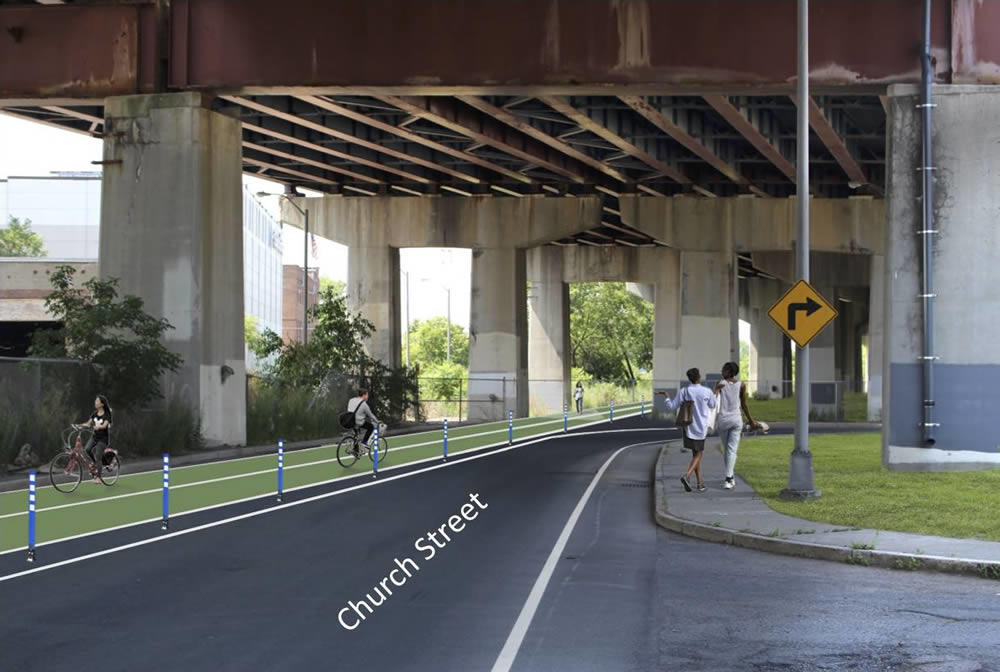
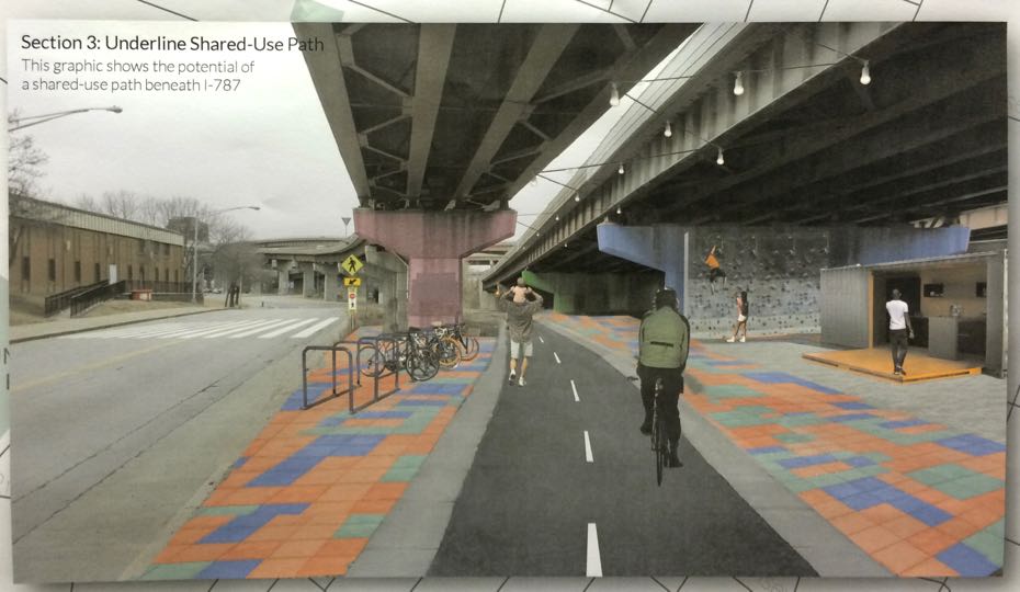
What part of the trail underneath 787 could look like.
The city of Albany is planning to start construction next year on the much-anticipated link between the Helderberg-Hudson Rail Trail and the Mohawk-Hudson Bike-Hike Trail.
The South End Connector is a key piece of the region's growing network of alternative transportation paths. When finished, it will offer a protected path for cyclists and pedestrians along the two miles from the rail trail's South End trailhead and the Mohawk-Hudson trail on the Hudson River. And it holds the potential to offer people within the South End a safer way to the riverfront.
The South End Connector has been in public planning for more two years, and the idea for the trail stretches back even farther. The city unveiled the construction plan and a new timeline last week at a public meeting.
Here's a look at what's in the works...
Here are some of the options for remaking upper Washington Ave in Albany
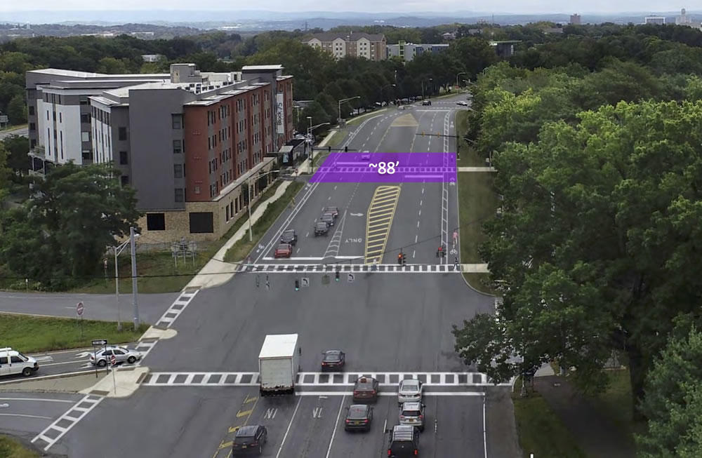
One of the options would re-stripe the road to include bike lanes.
The part of Washington Ave by UAlbany and the Harriman State Office Campus is a weird stretch. It's really wide. All sorts of ramps slip on and off it. There's been a lot of development, but it's hard to get from one thing to another. Pedestrians dart across it. And the speed limit probably feels frustratingly slow for drivers.
So: Are there ways to fix some of these issues, making the street work better and feel better for all sorts of people -- pedestrians, cyclists, drivers?
For the past six months the Washington Avenue-Patroon Creek Corridor Study -- a collaboration between the Capital District Transportation Committee, city of Albany, University at Albany, and engineering consultants -- has been looking into that question.
And Thursday evening during a crowded public meeting at UAlbany the engineers showed off a trio of possible designs for making over the road...
Making it someone's job (literally) to push Albany toward streets that are safer and friendlier for all sorts of people

Update: Kathy Sheehan tells Amanda Fries the city won't be adding the position, but will be assigning one of its current engineers to oversee complete streets and ADA compliance. [TU]
____
Should the city of Albany have a staff member whose full-time job is to keep the city on track towards its goal of creating streets that are safer and friendly to pedestrians, cyclists, and people with disabilities?
A group called Capital Region Complete Streets is pushing for the city to create such a position -- a complete streets coordinator -- and it would like to see the job included in the budget the city's working to finalize. The group has posted a doc outlining its argument (also embedded below). A clip:
It is evident that the City of Albany is making some progress with ADA Compliance, Complete Streets, and combating climate change, but the progress is slow. A Complete Streets Coordinator will help move things forward more efficiently, leading to a more inclusive, safe, walkable, and inviting city. One indicator that this position would be useful is that the city has had a Bicycle Master Plan in place since 2009, nearly a decade, yet has not come close to establishing a connected bicycle network. In fact, since 2009, the city has only managed to construct 4 mostly unconnected bike lanes (Clinton Ave, Northern Blvd, Madison Ave and Ten Broeck) that amount to about 2.8 miles.
A leading 21st century city is a safe and inviting place to live and work. Walkable streets, and navigable bike and transit networks are hallmark quality-of-life essentials for today's families, students, businesses and innovators. A Complete Streets Coordinator will allow Albany to be more responsive to the needs of its residents, while increasing its competitiveness with surrounding communities.
The city already has an ordinance requiring it to work toward "complete" streets, and a few years ago it put together what's essentially a recipe book for laying out streets with pedestrians and bikes in mind.
That look at traffic and pedestrian safety along New Scotland Ave is happening, and there's a meeting coming up to talk about it
The city of Albany has a public meeting November 13 to talk about the long-awaited New Scotland/Whitehall/Buckingham Corridor Traffic Study.
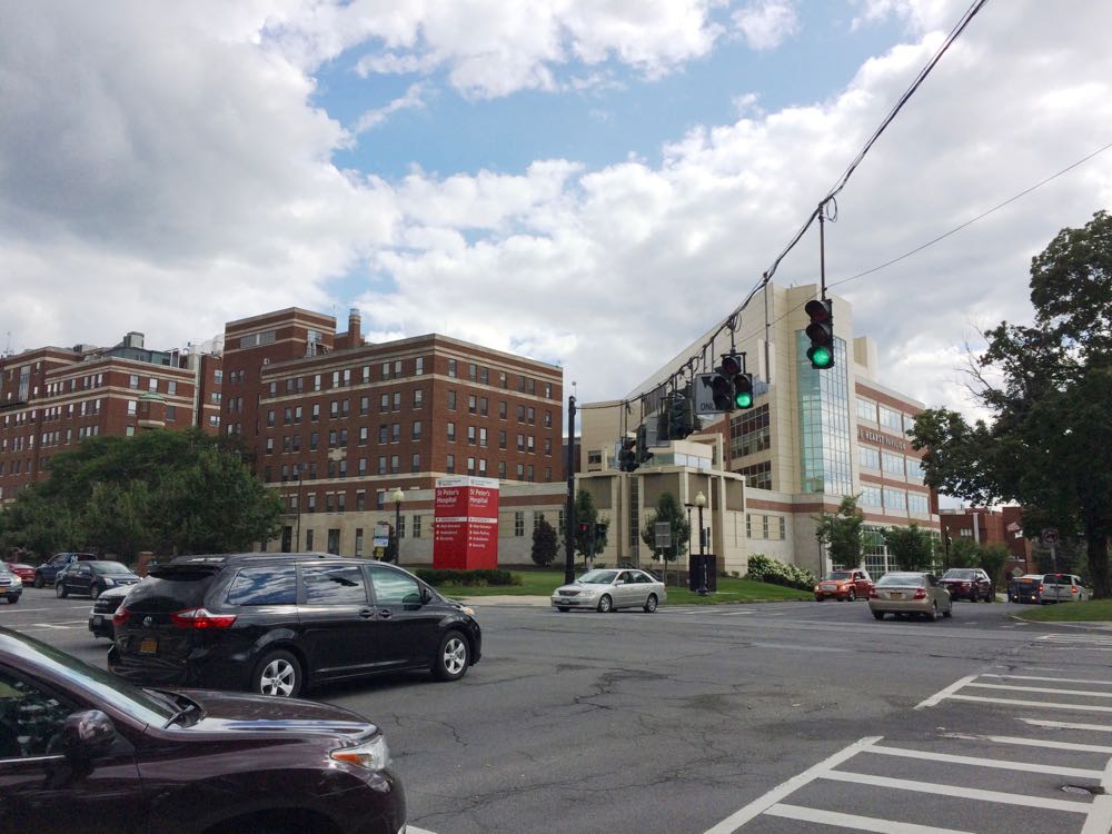
You might remember the city announced back in August 2017 that St. Peter's Health Partners was putting up $100k to study what mayor Kathy Sheehan described as "a significant increase in traffic" along the New Scotland Ave corridor, a major channel for the daily influx of commuters into the city. Speeding, pedestrian safety, and congestion have all become common complaints in neighborhoods along the corridor.
The city has hired the engineering firm Creighton Manning to assist with the project. Meeting blurbage:
This meeting will provide a brief overview of the study and draft project objectives. Community members will also have an opportunity to provide comments regarding existing needs and ideas for transportation improvements, and will help shape the future traffic patterns in this
It will be interesting to hear some of the ideas for the corridor. There are certainly some things that could be done with the street itself. Example: The segment of New Scotland from St. Peter's to Buckingham currently has a make-your-own-rules feel because of the (lack of) design and marking.
But it's also probably true that addressing the issues people are concerned about will also mean changing behaviors and other patterns. Is it possible for St. Peter's and Albany Med and other employers along the corridor to get fewer people driving to work alone? Are there ways to encourage development and residential choices so that more people can walk or bike to where they're going along the corridor?
There are a lot of pieces to fit together.
The public meeting is Tuesday, November 13 from 5:30-7:00 pm at the Mercy Auditorium at St. Peter's Hospital's 310 South Manning Blvd building. It's across the street from the main hospital building.
By the way: That's the same night at the South End Connector Trail meeting at the Howe Branch of the APL. That meeting's open house starts at 7 pm.
Earlier and elsewhere
+ Studying one of the channels of the daily commuting tide into and out of Albany
+ Parking as a daily choice
+ CityLab: Durham's Plan to 'Nudge' Drivers Out of Cars
The city of Albany is planning to start building that connector between the rail trail and the riverfront next year -- and there's a chance next month to see the plans
One of the renderings from 2017 of what the section under 787 might look like.
The city of Albany will show off the concept plans for the South End Connector Trail at a public meeting November 13 at the Howe Branch of the Albany Public Library.
The South End Connector is planned to be a roughly two-mile path to connect the end of the Helderberg Hudson Rail Trail in the South End with the Mohawk Hudson Bike Hike Trail along the riverfront. The public planning process for the project started more than two years ago, and the city and its consultants unveiled a plan in May 2017.
It's an important project because of the connection it will form between the two popular bike trails and the progress toward building a larger regional trail network. And it also potentially will open a safer way for people in the South End to get to the riverfront.
There are a two bits of news in the city's meeting announcement:
+ The city says it's anticipating that construction of the project's multi-use pathwill start in the summer of 2019.
+ A second phase -- that "include enhancements such as additional lighting and public art to the section of the route that goes under I-787" -- is scheduled for 2020. The city is calling that segment the "South End Connector Underline."
The public meeting is Tuesday, November 13 at at the Howe Branch of the APL (105 Schuyler Street). There's an open house from 7-7:30 pm and a project presentation from 7:30-8:30 pm.
Earlier
+ The plan to connect two major bike paths at the Albany waterfront (2017 May)
+ Plotting a path for the Albany waterfront bike trail connector (2016 June)
+ Mapping out the future for an alternative transportation network in the Capital District (2018 September)
+ Elsewhere: "Miami's Underline underscores potential of park projects" [Curbed]
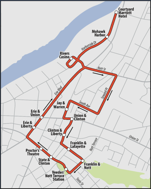
CDTA is starting up another free shuttle service around downtown Albany on the weekends
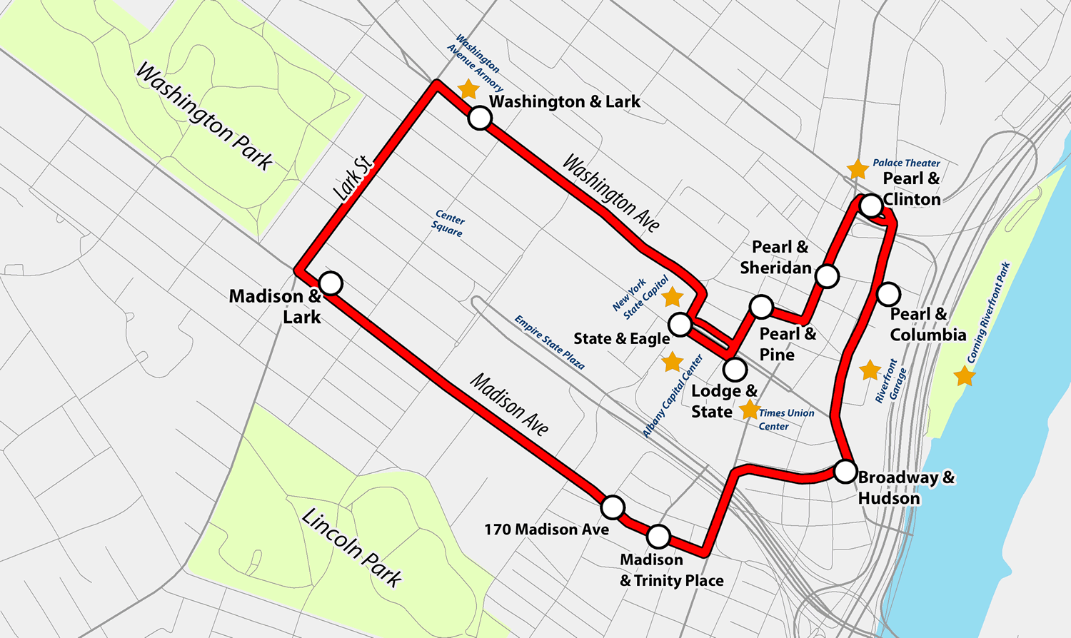
CDTA is starting up a free downtown Albany service it's calling Capital City Trolley today. Blurbage:
The Capital City Trolley will begin on Thursday, October 25 and operate Thursday, Friday and Saturday nights. Service will begin at 5:00 p.m. and conclude at 12:30 a.m. with a trolley arriving every 20 minutes. Schenectady-based software and logistics company, Transfinder has enhanced its CityFinder mobile application that allows users to track trolley location and highlights detailed points of interest.
The service will offer convenient stops near key attractions, including the Albany Capital Center, the Times Union Center, the State Capitol, the Palace Theatre, the Corning Riverfront Park, Quackenbush Square, the Riverfront Parking Garage and the Washington Avenue Armory.
That's the route map above (here's a larger version).
You might remember that CDTA ran a similar service -- the Capital City Shuttle -- during the summer of 2017. The route for the shuttle stretched from the Warehouse District to Washington Park. At the time CDTA CEO Carm Basile said they were thinking the service could eventually be a loop for downtown. And that looks a lot like the new map.
The CDTA press release touts the new service as a link between commercial corridors of Lark Street and downtown Albany.
But another way to think of it is like an extender for other options. You could take a bus, bike, Uber/Lyft, car and then use the trolley service to circulate through a few different spots in the same night.
CDTA advertises on AOA.
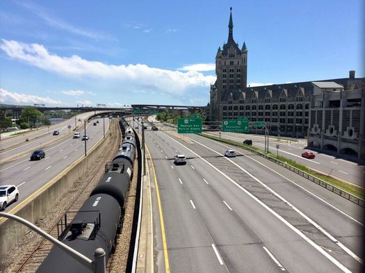
Gawking at the new Schenectady train station
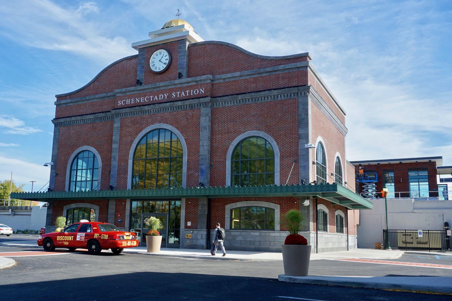
In a bit of a surprise the new Schenectady train station opened this past Wednesday, a few weeks ahead of the announced schedule. The $23 million station is the replacement for the old 1970s station that was demolished last year.
We had a few free minutes in downtown Schenectady today, so we stopped by to gawk at the station. It's small, but nice. And it has that new station smell.
We've included a handful of photos if you'd like to have a look.
The design is said to be inspired by the old-old Schenectady train station -- Schenectady Union Station, the one built in 1910 -- that was knocked down in 1971. For a while Schenectady's train service was moved to a stop in Colonie. See Carl's history of the demise of the old-old station.
As nice as the new station is, the best thing about it might be its location downtown just off the corner of Erie Boulevard and State Street. Of the Capital Region's four core cities, Schenectady is the only one that still has an operating train station right in its downtown. It's a reminder of what could have been for a place like Albany.
It's kind of great that you can walk to a train in the heart of Manhattan, say, and hop off right in downtown Schenectady and walk to a destination there.
A little push up the hill
Wrapped into my update this past week about what it's been like to use a bike as one of my primary ways of getting around town was a lament/complaint/whining about pedaling up the rather large hill in downtown Albany.
Because of that -- and because it's Friday afternoon -- here's a video of the CycloCable, sort of a ski lift for bikes, in Trondheim, Norway. (See also this CityLab article about it a few years ago.)
The odds of something like this being built in downtown Albany are essentially zero, and probably for some good reasons. But part of me kind of wants to see it proposed just to watch the reaction to the idea.
I mean, it's no gondola...
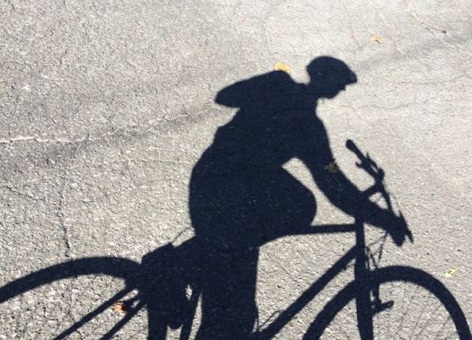
A year later I'm still using a bike to get around town -- here are a few thoughts about how that's worked out
About this time last year I shared how I ended up becoming a person who uses a bike as one of my primary ways of of getting around town.
A year later I am still that person. (Even the Times Union says I'm a cyclist.)
And here are a few thoughts about how that's worked out...
Walkable Albany survey
The new local group Walkable Albany has posted a survey looking for public feedback about places in the city that could use some attention in terms of pedestrian amenities and safety. Survey blurbage:
Walkable Albany is seeking your input about what places in Albany need improvement so that we can build a list of places in Albany to focus on in our advocacy efforts.
Walkable Albany is a group of Albanians who want to advocate for better streets. We believe Albany is a beautiful city with a historic walkable core and transit-friendly outer neighborhoods. Its core should be embraced for its walkable urban potential and its outer neighborhoods should be improved to make walking easier, safer, and more useful.
Pedestrian safety and complete streets should be a top priority for the City of Albany. Neighborhood and downtown streets should be designed to protect pedestrians and slow traffic whenever it is appropriate. Safe spaces for all road users, including bicyclists and alternative transportation options, are essential.
These sorts of topics -- walkability, dangerous intersections, urban planning -- get discussed fairly often here at AOA, so we figured you might be interested in this survey.
The founder of Walkable Albany is Andrew Neidhardt. The group has a meeting next Monday, October 15 at the Washington Ave Branch of the Albany Public Library at 6:30 pm.
Mapping out the future for an alternative transportation network in the Capital District
The Capital Region already has a handful of popular biking and walking trails, but if you zoom out a little bit and look at the whole picture you can the see the outline of something a lot bigger.
That something is what Jennifer Ceponis, a senior transportation planner for the Capital District Transportation Committee, describes as an alternative transportation network: "Much like we have a highway system for cars -- with supporting roads and arterials that feed into that -- we want people to be thinking that the region can have a similar system but for bicycling, walking, and other recreational activities."
Toward that goal, the planning org has put together the Capital District Trails Plan, a map toward a future in which you might be able to ride a bike from, say, Voorheesville to Saratoga Springs and beyond on a network of paths.
Here are a few highlights.
The Albany Police Department has e-bikes -- they're still not exactly legal for the rest of us
Thank you, Home Leasing Construction who donated three pedal assist bicycles to the Neighborhood Engagement Unit this morning! Check out Chief Hawkins taking one for a spin on Madison Avenue. #Albany #CommunityPolicing pic.twitter.com/sIVE2sEvNe
— Albany Police (@albanypolice) September 12, 2018
Noted: The Albany Police Department has e-bikes, as that tweet above pointed out this week.
"Pedal-assist" e-bikes are the same sort of bikes that advocates had been trying to get formally legalized in New York State during the past session of the legislature. The push didn't make it over the finish line.
E-bikes are increasingly popular around the country because the little electric motor -- which kicks in when you pedal -- makes it easier to go up hills and maintain speed. So they can be helpful for people who commute by bike, have gotten a little older, and or have a physical limitation that might otherwise keep them from biking. (Also: They're really fun. Riding one feels a bit magical.)
You can buy the bikes in shops here. But they're still not technically legal because of state law. (New York City has pursued its own rules.) That not only puts them in a gray area for regular bike riders, it also means bike share systems won't hop on board with them here, even though the major bike share companies are heading in that direction other places.
Earlier
+ E-bikes stretch the idea of what a bike can be in interesting ways, but they're stuck in a gray area here in New York
+ Another push to get e-bikes up the hill to legalization in New York State
Crossing the Black Bridge
We finally got a chance to check out the new paved path in Green Island that leads up to the southern end of the Black Bridge. And short story short: it's nice.
The Black Bridge is worth checking out sometime if you haven't already. There's a small parking lot at the end of Cannon Street on the Green Island side, and it's a short pedal from downtown Troy via the Green Island Bridge.
The bridge connects Green Island and Van Schaick Island in Cohoes across one of the Mohawk River's curling paths into the Hudson River. And it's part of a multi-use path that connects Green Island, Van Schaick Island, Peebles Island, and Waterford. The roughly two-mile corridor -- the Delaware Ave path in Cohoes -- is a nice walk or pedal as you pass by the fairways of the Van Schaick Island Country Club, the Van Schaick Mansion, a bunch of new residential developments in Cohoes, the old Matton Shipyard, cross the bridge onto the northern end of Peebles Island, and then cross another bridge over to Waterford with a view of the locks.
The setting is beautiful -- and a little bit wild. Late Sunday afternoon we glided past a deer and saw a bald eagle from the Black Bridge.
The Albany airport's getting terminal upgrades, a new parking garage, and a new connector road from Exit 4
The Albany International Airport is set to get terminal upgrades and a new parking garage as part of a $42 million renovation -- and there's now a set plan for a new "airport connector" roadway at Exit 4 off the Northway.
The Cuomo admin announced the upgrades and exit reconfiguration Tuesday. Press release blurbage about the planned upgrades for ALB, for which the state is chipping in $22 million and the Albany County Airport Authority is providing the rest:
New Parking Garage -- The project will construct a 1,000-unit, multi-level parking garage, expanding airport parking capacity by 20 percent. The pre-cast concrete garage will provide a heated pedestrian walkway to the airport terminal. Energy-efficient LED lights will illuminate that bridge, enhancing visibility as well as vehicular and pedestrian safety.
Parking Access Improvements -- The project will install new LED electronic signage, car counting devices, and interactive access control devices that utilize advanced GPS technology to locate available parking spaces and provide wayfinding messages that direct motorists to them. The existing parking system is nearly 20 years old and its electronic controls are in disrepair.
Terminal Rehabilitation and Passenger Amenities - The project will rehabilitate the terminal, including escalators, restrooms, waiting rooms and the food court. Improvements will include new carpets, wall finishes, tile floors, energy-efficient lighting fixtures and better Internet connectivity.
(We hope the airport's art gallery and public art get some dollars, too -- they're our favorite part of ALB.)
And here are some bits -- and explainer renderings -- about the new $50 million airport connector roadway and the reconfiguration at exits 4 and 5:
Here's the proposed design for the Albany Skyway
Over the years thousands of people have driven along the off-ramp leading to Clinton Ave in downtown Albany that's in line to become the Albany Skyway elevated park. But walked the almost half-mile curve? That's probably just a handful.
"It was an amazing surprise to be walking on the Skyway," said Capitalize Albany president Sarah Reginelli, one of the few people to trace the route on foot. "Even with none of the amenities in place, it was still this really enchanting walk because you get all of these vistas and vantage points you wouldn't otherwise."
Last week at The Palace, Capitalize Albany -- the city of Albany's economic development arm -- presented the work of the team that's been designing the Albany Skyway.
Here are a handful of renderings, bits about the design plan and cost, along with a few questions and thoughts.
A piece of street with new purpose
Check out this re-purposed street segment at Washington Ave and Henry Johnson Boulevard in Albany. The segment is closed off and now serves as bus stop and parking spot for a bike share hub. (Here's how it looked before.)
That bus stop is one of the new/moved stops connected the new consolidated bus stop / pedestrian upgrades on Washington Ave at the Albany Public Library. The consolidated stop allows the #10 (Western Ave) and $12 (Washington Ave) to run straight up their respective trunk streets. (The old bus stop in front of the armory didn't allow the buses enough room to switch lanes and drive along the south side of Townsend Park.)
The transportation planner/engineer term for this sort of street segment is a "slip lane."
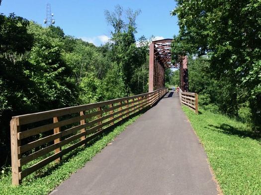
A few more bits about the present and future of the Helderberg-Hudson Rail Trail
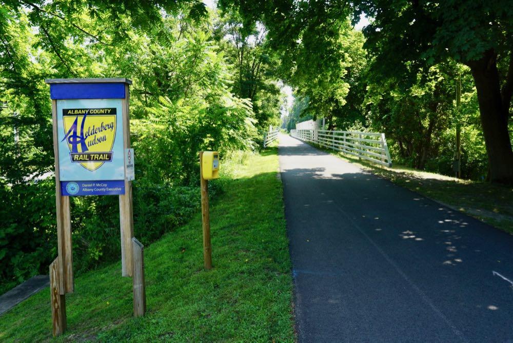
The second segment of Albany County's Helderberg-Hudson Rail Trail is now paved -- as noted earlier this week -- meaning there's now 9 miles of (almost) continuous pavement from the South End in Albany all the way out to Voorheesville.
We got a chance this week to talk with Albany County exec Dan McCoy about the present and future of the popular trail.
"I go around doing my state of the county every year, people are like rooting us on -- when's it going to be done, when's it going to be done, when are you going to fix the problem with it," McCoy said in reference to the remarkable popularity of the rail trail. "And these are good issues to have."
Here are a few bits about paving, the depot building in Slingerlands, new amenities, bathrooms, bike share, and what's still ahead...
The second section of the Helderberg Hudson Rail Trail is now paved
Check it out: The second segment of the Albany County's Helderberg-Hudson Rail Trail -- from Slingerlands to Voorheesville -- is now paved.
We took a spin on the 4-mile segment this Saturday. The newly-paved section starts just west of the Slingerlands parking lot, crosses the Font Grove roads, slices through many shady sections alongside fields with views of the Helderbergs through the trees, passes the Hilton Barn in New Scotland, spans State Farm Road, traverses the Vly Creek, and ends at Grove Street in Voorheesville. The pavement is luxuriously smooth.
That makes (almost) nine miles of continues paved trail from South Pearl Street in the city of Albany out through Bethlehem, New Scotland, and Voorheesville.
Here's the new consolidated CDTA stop / pedestrian upgrades at Washington and Lark
Some quick follow-up about that project to consolidate the bus stops near Washington Ave and Lark Street and add in a few pedestrian amenities. (The project has been in the works for a few years and there was some drama involved.)
The new bus stop shelter is installed in front of the Albany Public Library. The new mid-block traffic signal and cross walk is operating. (The queue jumper light for the bus wasn't unwrapped as of Tuesday.) And this past Sunday CDTA switched a bunch of bus lines over to the stop and their new, more streamlined routes west. Update: Here are large-format diagrams from CDTA explaining the route and stop changes.
The eastbound -- that is, toward downtown -- routes and stops didn't change.
The goal of the project was to make the intersection work better for buses and pedestrians. The previous stop arrangement was cramped, and it forced the the lines headed west along Western and Washington to first make their way up Central and then cut back to their intended path. The new consolidate stop has more space and allows the buses to directly head up either Washington or Western.
And the new mid-block signal and crosswalk is intended to make it safer to cross the long block between Lark and Dove. (So use the crosswalk!)
The cost of the project was $1.3 million and it was backed by state and federal money.
Here are a few more pics -- and those diagrams -- if you'd like gawk...
The Madison Ave traffic calming project is finished -- so what's next?
The new section of the Madison Ave traffic calming project in Albany -- the "road diet" -- has been in place for more than a week. But now it's press conference-official after an event this past Friday.
"Investments like these help to spur economic development and we need to be focused on growing our tax base, growing businesses, making sure that our neighborhoods are neighborhoods of choice for people so that we can continue to attract them to the City of Albany," said mayor Kathy Sheehan after the event at Madison and South Lake. "So this was about taking that opportunity of looking at the fact that we were going to repave this road and building an infrastructure that helps to make everybody safer."
And people have had a lot to say about this project. During the planning process, during the first phase, and now that it's finished.
So here are a few more things -- about new amenities that aren't bike lanes, about the city figuring out how to implement these sorts of ideas faster, and what might be next.
Here are the most popular drop-off spots for Uber and Lyft in this area
A popular spot for both Uber and Lyft.
It's now been a year since ride-hailing services such as Uber and Lyft have been allowed to operate across New York State.
And this week the two companies shared lists of their most popular drop-off destinations in the Capital Region.
Let's have a look.
Cruising along the second phase of the Madison Ave Road Diet
We got a chance to bike along the new section of the Madison Ave traffic calming project late Monday afternoon. New pavement + freshly-striped bike lanes = a nice ride, even alongside plenty of vehicle traffic.
The second phase of the "road diet" stretches from Partridge to Lark. It's part of an overall effort to reconfiguration the Madison Ave corridor from Allen to Lark to increase road safety and amenities for cyclists and pedestrians.
The new layout replaced a four-lane configuration (two vehicle lanes in each direction) with a three-lane layout (one vehicle lane in each direction, with a turn lane in the middle) and bike lanes on each side. Phase two also includes new traffic and pedestrians signals. Those signals are one of the keys to project -- traffic modeling indicated that signal coordination should be able to keep vehicle traffic travel times along the corridor at levels close to the old layout.
The new section isn't quite finished. Some of the striping -- including the zones for buses -- isn't down yet. But the city said Monday that the phase will be completed soon -- probably within the next week or so.
We'll circle back around to the project when it's officially complete (Update: And here's that post.), but just on first look it's remarkable how much different the corridor feels with the new configuration.
Here are a few more pics if you'd like to gawk...
Albany is expanding its pay-by-plate parking meters and mobile parking payment
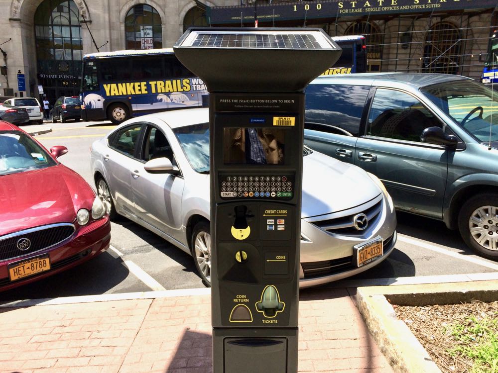
One of the new pay-by-plate meters on State Street last summer.
The Albany Parking Authority is expanding the use of the pay-by-license plate and pay-by-app parking meters. The new meters will be replacing the "pay-and-display" multi-space meters -- the ones where you print out a ticket and place it on the car dash. Press release blurbage:
These upgrades to the parking experience will allow visitors and residents the ability to add time to their parking session from their smartphone, and with the pay-by-plate meters, they won't need to return to their car to place a ticket on the dashboard. In addition to paying for parking through the app, Albany residents and visitors can now conveniently monitor their parking sessions, view payment history and receive email receipts.
The APA says it will start rolling out the new-style meters in the areas around downtown and the Capitol next week. The multi-space meters in other parts of the city are scheduled to be replaced in July.
The authority says the new meters are going to be next to the old meters, so you may see one wrapped-up meter next to another. When the new meters are activated, the old meter will be wrapped and marked for removal.
All the Capital Region's sidewalks
We enjoy both maps and sidewalks.
So, not surprisingly, we were interested in this new map of all the sidewalks in the Capital Region. That's some 1,225 miles of sidewalk.
The map is the the product of three years of work by the Capital Region Transportation Committee. It was created primarily for compliance work for the Americans with Disabilities Act, and also to assist with planning for pedestrian infrastructure.
Also: It's a map of all the sidewalks.
Here's the full map and a few bits...
An old Northeast city, historic sites, a protected bike track
Farther afield, but interesting in light of conversations here...
Check out this short Streetfilms video about the new Connect Historic Boston Bike Trail -- a protected bike lane that winds its way between historic sites in Boston. (As you might have guessed from the name.)
Boston is not Albany or Troy or Schenectady, obviously. But like the cities here, it is old and (even more) dense and in the Northeast. So apparently it's finding ways to overcome the sorts of issues and complaints that often accompany proposals for this sort of bike infrastructure here -- like the effect on car traffic and parking and snow removal. And there's research that indicates this sort of robust bike infrastructure is both safer and encourages more people to ride.
Anyway, here's a ride-along video of the Boston trail from last month.
By the way: The under-construction South Troy Riverfront Bikeway is in line to get a two-way cycle track like this, which would be the first for this area.
Earlier
+ Albany's sister city bike paradise
+ Another push to get e-bikes up the hill to legalization in New York State
Another push to get e-bikes up the hill to legalization in New York State
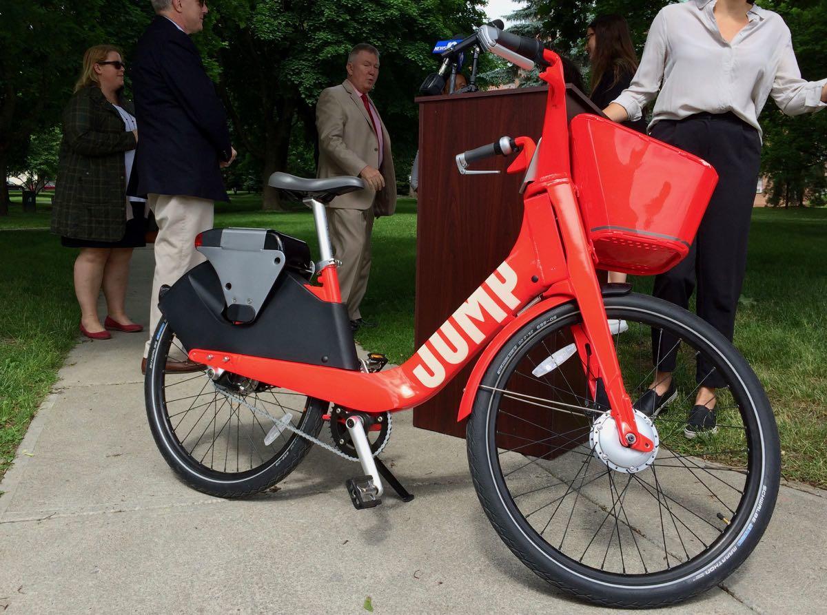
One of Jump's bike share e-bikes.
E-bikes hold the potential to stretch the use of bikes in all sorts of interesting ways, but they're not currently legal in New York State.
There's a push to change that, and advocates are pedaling hard to make it up the hill before the state legislature ends its current session later this month.
On Wednesday reps from the company behind the bike share operated by CDTA were in town to argue the case for e-bikes along with a handful of state and local leaders. The pitch: e-bikes can be a new way for people to commute, they'll open tourism opportunities, and they'll expand the pool of people who ride bikes.
So here are a few bits about how e-bikes might work with bike share in the Capital Region, and a check-in on where things are at in the state legislature...
The Helderberg-Hudson Rail Trail is set to get a new paved section this summer, and a few more bits about its future
Albany County's Helderberg-Hudson Rail Trail is already one of the most popular bike/hike trails in the region, even though it's just a few years old.
And this summer is shaping up to be a big season for the path as the county prepares to pave the segment from Slingerlands to Voorheesville, adding another four miles of asphalt path.
Here are a few things about the future of the trail -- both in the short term and farther out...
How to get to the indoor bike parking at the Empire State Plaza
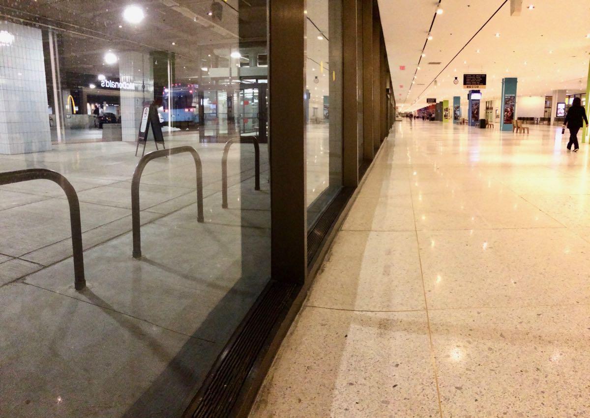
Pretty much the best parking spot at the ESP.
By the way: There is indoor bike parking at the Empire State Plaza -- on the concourse level, even.
The bike racks are just outside the door to the bus turnaround area in the middle of the concourse, right across from the food court.
Maybe you've seen these racks and wondered how one ever get their bike there, because it's not exactly apparent. (Or you're googling this now.)
Well, wonder no longer.
E-bikes stretch the idea of what a bike can be in interesting ways, but they're stuck in a gray area here in New York
Bikes can be a good way to get around. They don't take up a lot of space on roads. They're environmentally friendly. They're fun.
There are also some drawbacks that prevent people from embracing bikes as an everyday transportation option: the relatively slow speed of travel, the sweat, just the general physical exertion of riding.
E-bikes -- which give riders a little help thanks to an electric drive -- can address a lot of these issues. Riding one feels a little bit like magic. And their popularity is on a big upswing.
But there's a snag: New York State doesn't have clear rules for e-bikes.
And that casts some doubt on their future here.
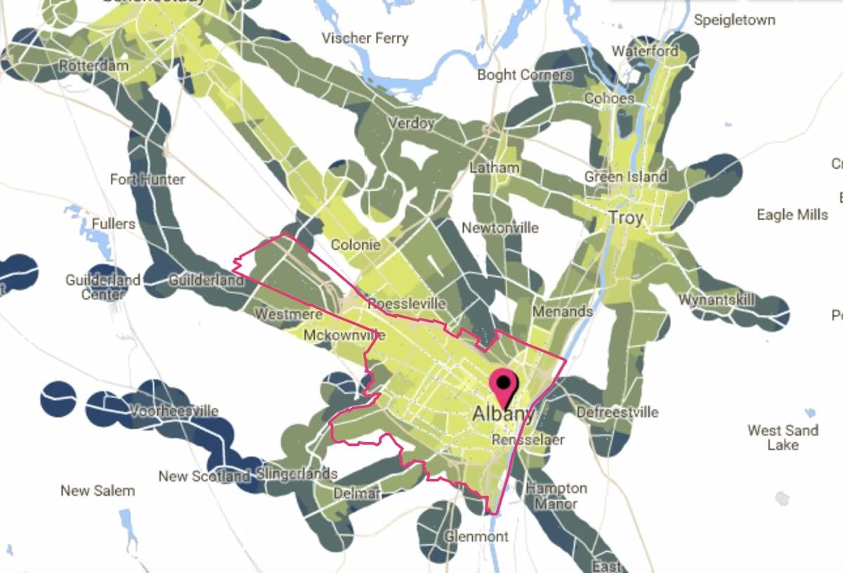
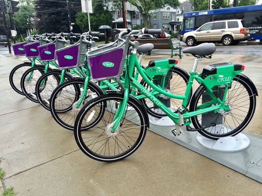
Here are the new bike share service area maps and hub locations
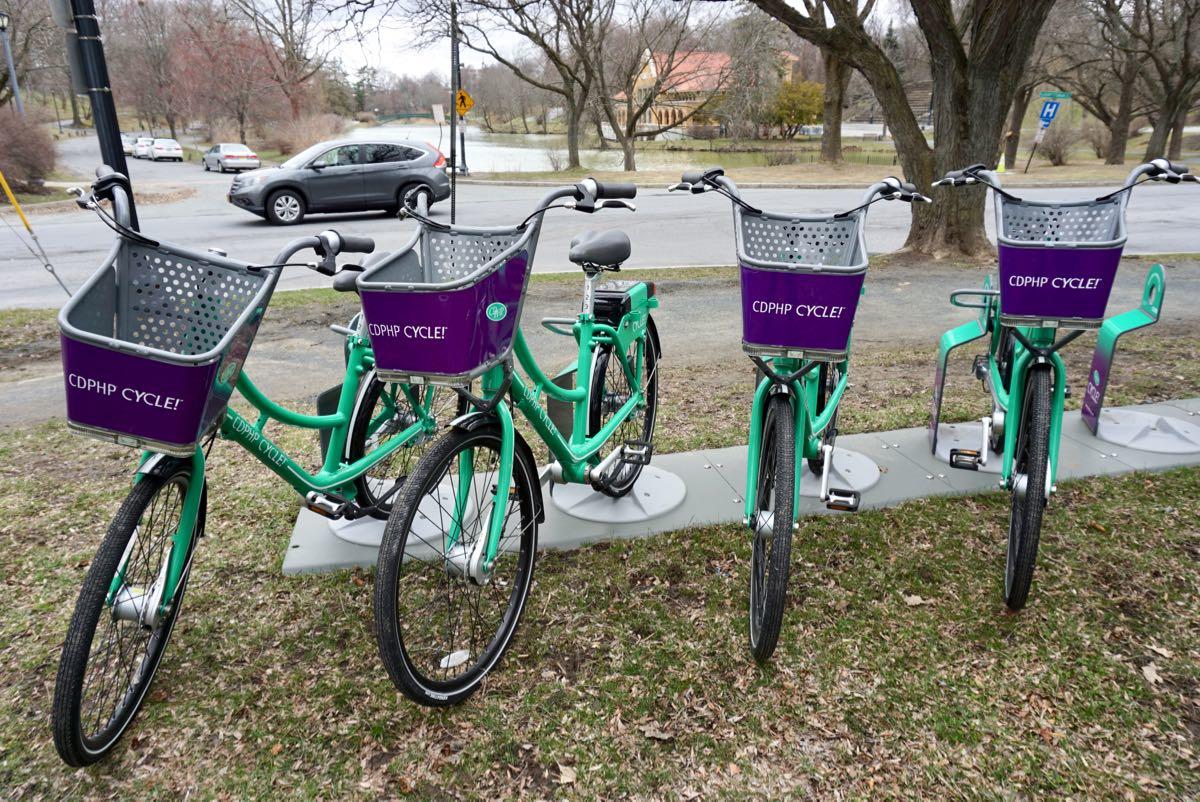
Washington Park is one of the bike hub location holdovers from last year, but this year it has double the number of spaces.
The new season for the bike share operated by CDTA -- CDPHP Cycle -- started in mid-April. And the for the second season, the transit org promised more bikes, more hubs, and a wider service area.
The details for that expansion are now out. CDTA has released maps for this season's hubs -- some already place, some still to come -- as well increased geographic boundaries for the system. The transit org says this season will include 350 bikes (versus 160 last year) and 80 hubs.
The expanded system areas in Albany, Schenectady, Saratoga Springs, and Troy are notable for a few reasons. 1) The relatively compact boundaries for the first season were a frequent complaint. 2) The new boundaries cover much of their respective cities, including more neighborhoods beyond the downtown cores. 3) The "out-of-system" fee for dropping a bike outside the boundary is $100.
See below for maps of the planned rack locations. The bike share's website has the racks that are currently in place (along with counts of how many bikes are available at each location). There's also a mobile app with this info.
The new season of the CDPHP Cycle bike share has started up
The hub in Washington Park is one of the locations that's gotten an expanded 10-bike rack this year.
Check it out: The new season for the bike share operated by CDTA -- CDPHP Cycle -- started Wednesday. Bikes are back out on the racks and they're available to use.
This is the second season for the bike share, and the first full season. (Last year's season started in late July.) This time around includes double the number of bikes (320 vs. 160) and more than 20 additional rack locations. You can see where bikes are available -- and reserve one -- via the bike share's online map or mobile app.
And that early-bird pricing for a full-season membership is still available through April 19. The $65 membership (it's usually $85) includes an hour of bike use per day.
The base price for using a bike without a seasonal pass is $5 per hour (prorated to the minute), with an "out of hub" fee of $2 and a "brought to hub" bonus of $1. (The bikes don't have to returned to a hub. The electronic tech for renting the bikes is on the bikes themselves, and they're equipped with GPS.)
CDTA exceeded its membership goal for last season, ultimately signing up 2,467 people, logging 11,481 trips that averaged 2.34 miles per trip. One of the goals for this season, with the additional bikes and racks, is to expand the service area further into neighborhoods beyond the downtowns of Albany, Schenectady, Troy, and Saratoga Springs.
Earlier: What's next for the CDPHP Cycle bike share
CDPHP advertises on AOA.
There's a discount on CDPHP Cycle bike share memberships right now
The next season of the bike share operated by CDTA -- CDPHP Cycle -- is lined up to start later this spring. And the service is offering early bird pricing.
A season membership is currently $65 through April 19. After that the price increases $20. The membership includes 60 minutes of free bike use per day, so if you think you'll be using the bikes often, this could save you a few bucks.*
The base price for using a bike without a seasonal pass is $5 per hour (prorated to the minute), with an "out of hub" fee of $2 and a "brought to hub" bonus of $1. (The bikes don't have to returned to a hub. The electronic tech for the renting the bikes is on the bikes themselves, and they're equipped with GPS.)
In addition to the season pass, there's a $15 monthly membership that includes 60 minutes of time each day. And there are also student rates, which are half the typical price at each level.
By the way: The "out of system area" fee this season will be $100. (It was $25 in 2017.)
CDTA is making the full switch to Navigator at the end of this week
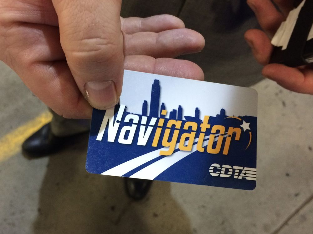
A heads-up/reminder: This is the last week that CDTA will be accepting its paper swiper cards.
The transit org stopped selling the swipers -- er, "magnetic-striped fare media" -- at the end of December. But they've still been good for use through the end of this month as part of a transition period. That ends Saturday. So got an old change card with money left on it or something similar? Use 'em or lose 'em.
The swiper phase-out is part of the switch over to the plastic Navigator smart cards, which debuted to the general public a little more than a year ago. The free cards offer a bunch of benefits, including the ability to link them to an online account so they can be automatically refilled or to have the value transferred to a different card if the card is lost.
We've been using the Navigator card for the past year and really like it, especially the autobuy option. (Though we gotta admit it took us a while to get the hang of touching the card just so on the fare boxes.)
There's also now a Navigator mobile app that can function as a payment system for fares in the same way as the cards.
People who pay for a bus ride with an institutional ID -- because your school/employer/org has a "universal access" arrangement with CDTA -- will continue to be able to do so. And CDTA will continue accepting cash, though it stopped issuing change at the beginning of this year.
Earlier: There's a big change coming up soon with the CDTA fare system
Thinking about the future of Washington Ave
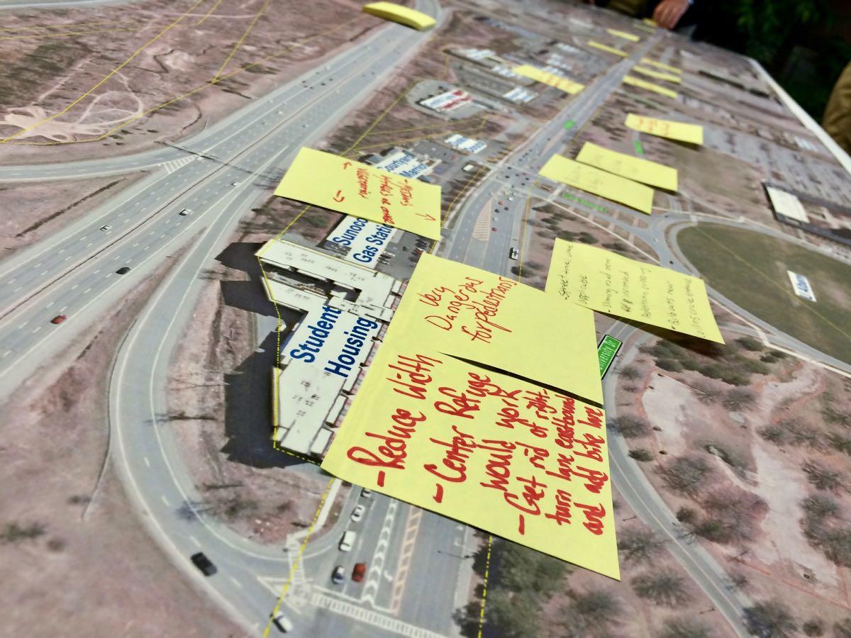
Could there be a safer, friendlier, better version of upper Washington Ave in Albany?
That was the question at the heart of the the public kickoff meeting Wednesday for the Washington Avenue-Patroon Creek Corridor Study. The Capital District Transportation Committee is working with the city of Albany, the University at Albany, and engineering consultants to look at how the important transportation artery could work better for all sorts of people -- pedestrians, cyclists, and drivers.
This topic has been popping up a lot in recent years because of the ongoing development along the corridor, including the addition of private student housing. As a first step in addressing some of these concerns, the city of Albany lowered the speed limit on the stretch from 45 to 30 mph in 2016.
"We want to know from the users of the road, the neighbors of the road, what you think of the road, what you think the problems are," CDTC executive director Mike Franchini told the crowd.
Here are three quick takeaways...
787 is sticking around for a long time, but if you want to change it the time to start is now
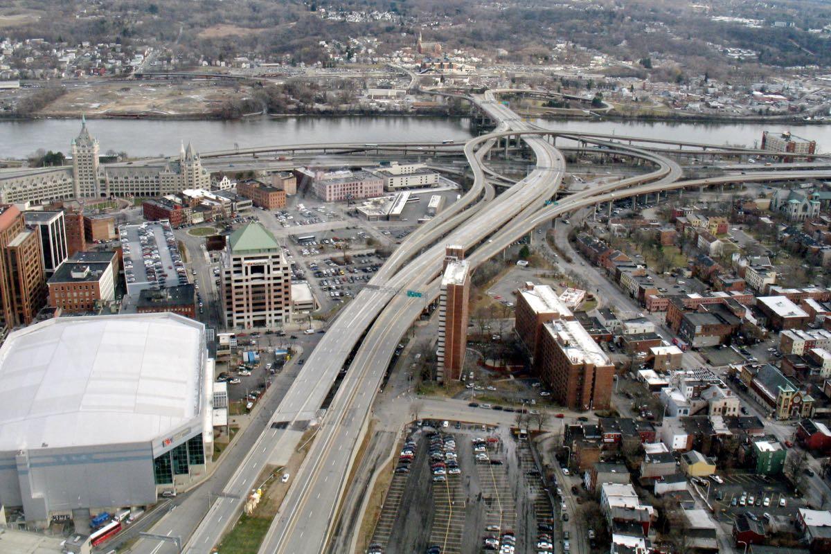
Let's just get right to the point most people want to hear about: The new draft of the I-787/Hudson Waterfront Corridor Study doesn't lay out a detailed plan for making the sort of radical changes to the highway that so many people have desired for so long.
But the long-awaited report -- the product of a process that stretches back to 2014 -- does provide an extended outline of possibilities for potentially making over one of the Capital Region's key pieces of infrastructure and the Hudson River waterfront.
"We have options, what we need is a champion, we need support, we need funding to go to the next step," said Capital District Transportation Committee executive director Mike Franchini this week at an open house for the project at the Albany Public Library. CDTC headed up the report in collaboration with the state Department of Transportation, the city of Albany, and a team of consultants. "And that's really going to depend on the public and the municipalities in the area whether they want to go there or not."
Here's a big overview of what's in the report, along with a few thoughts for the future...
Studying the future direction of Washington Ave
What sort of (figurative) direction should upper Washington Ave in Albany take?
That's the question at the center of a new project to study the corridor -- and there's public meeting coming up next week to talk about it. Project blurbage:
The Washington Avenue - Patroon Creek Corridor Study is a collaborative feasibility study for the area along Washington Avenue, between Brevator Street and the Eastbound I-90 On-ramp (Exit 2), across from the University at Albany main campus entrance.
?This part of Washington Avenue is a major arterial roadway--connecting residential and commercial properties that have grown along Washington Avenue Extension, west of the project area, to Albany's midtown and Downtown core, east of Brevator Street.
The Capital District Transportation Committee, in coordination with the City of Albany and the University at Albany, NY, are investigating this area to identify key opportunities for complete street design elements. Further modifications to the corridor will improve safety and reduce roadway conflicts to compliment the newly reduced speed limit.
The public meeting is Wednesday, March 21 from 4:30-6:30 pm in the Hall of Fame Room at the SEFCU Arena on the uptown UAlbany campus.
There's been a lot of development along this stretch of Washington Ave in recent years, including more pedestrians thanks in part to the new private dorm (with another on the way).
In 2016 the city lowered the speed limit from 45 mph to 30 mph. But the design of the road is the same -- and it's designed for much higher speeds, so 30 feels very slow and it's easy to go faster than that if you're not paying close attention.
So, it will be interesting to see if something like the Madison Ave Road Diet would be appropriate there.
Earlier:
+ A way to say "more like this" when it comes to talking about how streets are designed
+ A cookbook for designing Albany streets
Ideas for the Albany Skyway
One rendering of one possible version of the project.
Three million dollars has a way of changing people's perspective of what's possible.
The idea behind the Albany Skyway -- to convert a lightly-used off-ramp from I-787 to Clinton Ave in Albany into a connection between Broadway and the riverfront -- first popped up in plans for the Corning Preserve and downtown four years ago. It was, as mayor Kathy Sheehan said at a public planning meeting Thursday evening, a "sort of pie in the sky, almost dream" idea.
The almost dream is now almost reality thanks in large part to $3.1 million in funding the Cuomo administration announced for the project this week, a surprise boost that now has the planning moving forward.
"We're in a unique position of starting off on a planning exercise that ... doesn't have have us going out at the end of the day and hoping to make this project a reality," Sarah Reginelli told the crowd. She's the president of Capitalize Albany, which has been heading up the planning. "This project will be a realty."
So that's what members of the public, along with all sorts of officials, got together to talk about.
Here are a bunch of bits about what people said they'd like to see happen, along with a few thoughts about this project.
Capital District Trails Plan
The Helderberg Hudson Rail Trail
One multi-use trail for walking and biking is good. Two is better. But a network of interconnected trails is best.
Toward that goal, the Capital District Transportation Committee is working to develop a Capital District Trails Plan, and it's looking for public input:
The Capital District Trails Plan is a strategy to link together the various multi-use trails in Albany, Schenectady, Rensselaer and Saratoga counties into a single connected network of trails for everyone in the region to enjoy. This planning effort will identify existing trail locations throughout the region and work with local communities to envision potential new trail routes which will infill missing segments, connecting to each other and to key points of interest. This plan, sponsored by The Capital District Transportation Committee (CDTC), will involve the input from residents, community leaders and stakeholders through different public meetings, workshops and surveys as they are scheduled throughout the coming year. The goal is to develop a vision for a connected, regional network of multi-use trails that is accessible to all Capital Region residents.
Here are a few ways to offer input, whether it's a public meetings*, a survey, or a crowd-sourced map (check out the "trail concept" for a loop through Albany off the Helderberg-Hudson Rail Trail).
Paths such as the Mohawk Hudson Bike-Hike Trail and Albany County Helderberg-Hudson Rail Trail are already popular. And there are some interesting projects like the Albany Waterfront Connector and the Albany-Hudson Electric Trail in the works. From our perspective, one of the challenges/opportunities now is figuring out ways to connect local neighborhood routes to these paths so they can be more useful as transportation corridors and just offer more general access.
* Maybe these meetings could have been scheduled at times that would have made it easier for people to attend. Update: We hear these meetings are primarily for trail groups, planners, and public officials.
That long awaited report about the future of 787 is almost ready and there's a chance coming up to learn more and make your voice heard
The formal process for thinking about the future of 787 -- the I-787/Hudson Waterfront Corridor Study -- has been in progress for years. And now it looks like there's a product.
There's a public meeting to discuss the study report March 13 at the Albany Public Library Washington Ave branch. Event blurbage:
Learn about the study findings, progressed and potential strategies, and provide your thoughts on the study's report. This public open house will exhibit informational boards, invite your input on the report, and provide a presentation about the study findings by the project team at 4:30 p.m. and 6:30 p.m. on Tuesday, March 13th. The content of each presentation will be the same.
The open house is from 4-7:30 pm in the auditorium toward the rear of the APL branch.
This report -- headed up by the Capital District Transportation Committee, in collaboration with the state Department of Transportation and the city of Albany -- is the culmination of a process that started in 2014 and has moved slower than originally expected.
A transit-centric map of the Capital Region
Here's a follow-up of sorts to yesterday's post about the Capital Region's relatively low levels of traffic congestion, commuting, and planning for how to get around in the future.
An org called the Center for Neighborhood Technology has an online app called AllTransit that maps access to transit and jobs for locations.* It also digests all those bits into scores so they can be compared.
Here's the profile for the city of Albany, which scored a 7.8 -- "Very good combination of trips per week and number of jobs accessible enabling many people to take transit to work." (For some comparison, Colonie scores a 4.4 and Bethlehem a 2.5.)
One of the things that's interesting about this tool is the way it sort of creates what we sort of think of as as a topographic map of access-to-transit around the area. There are a handful of really high points -- the hearts of Albany, Schenectady, and Troy primarily -- and things slope downward from there.
*We could have sworn we mentioned this tool before, but couldn't find it while rummaging through the archive. It's probably all the way in the back of the cabinet, unopened, with the expiration date on the jar past.
(Thanks, Jen!)
Earlier:
+ The Capital Region's transit arteries
+ The potential impact of bus rapid transit
+ A brief (alternate) history of the Capital Region's much-admired light rail system
Traffic problems, relatively speaking
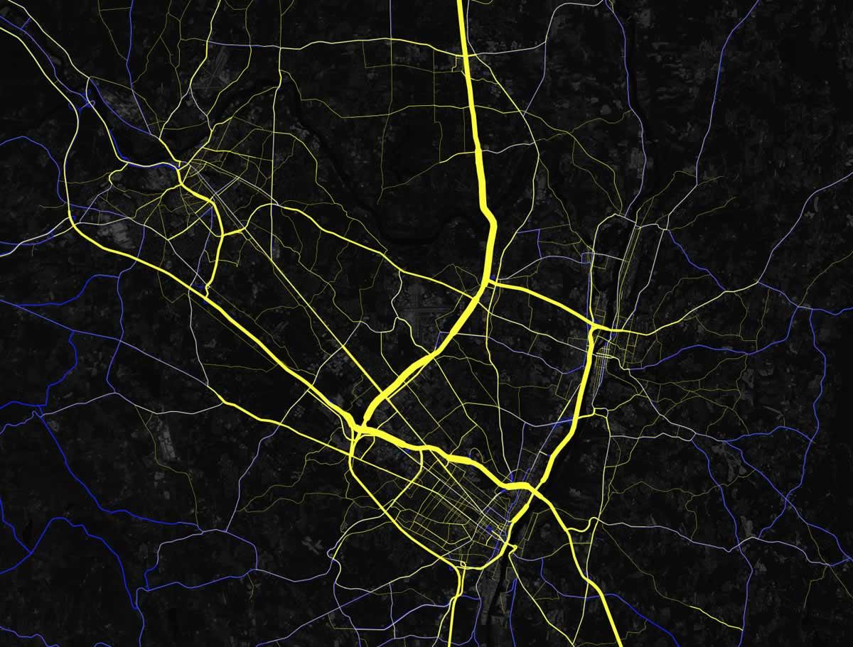
The Capital Region's traffic arteries, a clip from a national map created by Mapbox using data from the federal Highway Performance Monitoring System and OpenStreetMap.
Sometimes it's good to get a wider perspective on the sorts of things we all complain about.
Like traffic. From a national perspective, the Albany area doesn't really have traffic.
Albany ranked #118th in the United States for traffic congestion last year, according to the new global traffic scorecard from the transportation data consultancy INRIX (more about the report). Drivers in this area were estimated to spend just 4 percent of their driving time in congestion, 14 hours across the whole year.
In Los Angeles -- which topped the ranking for US cities and the world -- the total was 102 hours spent in congestion. And in New York City, ranked #2 in the US, the total was 91 hours.
Here are a few more things about that.
There's a big change coming up soon with the CDTA fare system
Heads up: CDTA has a big change set for the start of the new year when it will stop selling its paper "swiper" cards.
The move is part of the transit org's transition over to the new Navigator smart cards. Here are a few more bits about what's up...
What's next for the CDPHP Cycle bike share
Today (Thursday) is the last day of the season for CDPHP Cycle, the new bike share run by CDTA.
A few of the first-year stats released by the transit org for the system, which included 40 stations and 160 bikes:
+ The bike share signed up 2,467 members
+ The system logged 11,481 trips
+ Those trips covered 26,877 miles (2.34 miles per trip on average)
Here's more about the bike share's first season and what's in the works for next year...
Mapping out a future for bikes in Troy
What's the route to follow to make Troy more bike and pedestrian friendly?
That's the question at the heart of the current push to create the Troy Bike Connections Plan. The backers of the project -- which include the city of Troy, the Capital District Transportation Committee, and Parks & Trails New York -- released a draft of the plan at a public meeting Wednesday evening.
And the materials are now online, if you'd like to have a look.
"There are a lot of streets in Troy that can be transformed with not a ton of engineering to become more bike friendly," said CDTC's Jennifer Ceponis Thursday, emphasizing the plan is a way of mapping out a direction for future projects as money and opportunity present themselves. "This is going to be incremental, for sure."
A few things about the proposed plan...
Capital CarShare expanding to Troy
Capital CarShare announced Monday that it's expanding beyond the city of Albany for the first time -- to Troy.
The membership car sharing service will two car stationed in the Collar City -- at 80 2nd Street (near the Troy Public Library/Russell Sage) and 585 River Street (near in the intersection with Jay Street and Capital Roots).
Capital CarShare is a local non-profit similar to services such as Zip Car, which have become popular in many large cities. (Capital CarShare was itself modeled on a similar non-profit service in Buffalo.) It launched in Albany in 2014, and has eight vehicles stationed around the city. Members pay a monthly fee -- as low as $5, depending on the plan -- then pay an hourly rate for using a car.
Talking about the future of biking in Troy, and the next segment of the Helderberg Hudson Rail Trail
The Helderberg Hudson Rail Trail.
Two bike-related events coming up that might interest you...
November 8: Troy Bicycle Connections Plan
There's a public meeting to present the draft plan for the Troy Trail Connections Plan Wednesday, November 8. About the plan: "The study will create a plan for bicycle facilities that connect major destinations and neighborhoods in the City of Troy to the Uncle Sam Bikeway and the planned South Troy Riverfront Bikeway."
The meeting is at the Tech Valley Center of Gravity (30 3rd Street). There's an open house at 6 pm, and the presentation starts at 6:30 pm.
November 13: Helderberg-Hudson Rail Trail
Albany County has a public meeting set for Monday, November 13 in Delmar to "gather input on the design of the Slingerlands Trail Head and planned paving project in 2018. After a brief overview, the county will distribute a sketch of the design along with markers for the public sketch out their thoughts." The meeting's at 6 pm at the American Legion post (16 W Poplar Drive).
The county is planning to pave the rail trail the portion of the rail trail that stretches from Slingerlands to Voorheesville. That would add about another 4 miles of path, bringing the total length from South Pearl Street in Albany to Voorheesville to about 9 miles. Here's a Mohawk Hudson Land Conservancy map that gives a quick look at the paved/unpaved portions.
How I ended up riding a bike as one of my primary ways of getting around town -- and how that's gone
So here's something I've been hearing lately: "You rode your bike here!?"
Because I did.
This past summer I made an effort to become a bike person. That is, not just a person who rides a bike for fun, but a person who uses a bike for transportation around town. (Though, really, it's still fun even if you use it that way.)
Here are a few thoughts on how that's gone...
Juice for electric vehicle sales
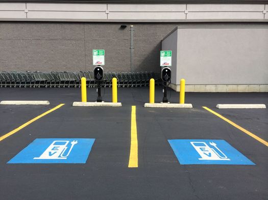
The number of electric vehicles sold in New York took a big percentage jump during the first half of this year, according to the Cuomo admin. Sales were up 61 percent from January to June 2017 compared to the same period in 2016.
The administration attributes to the jump to the new electric vehicle rebate the state started offering this spring. New York State is now offering up to $2,000 for qualifying vehicles, bringing the total potential federal and state rebate to $7,500. The Cuomo admin points to a sharp uptick in sales this year after the rebate started (sales January to March were up 44 percent compared to 2016, and up 74 percent April to June.)
The total number of electric vehicles sold in New York State during the first half of this year: 4,209. And through the end of August, there have been 2,332 "Drive Clean Rebate" applications submitted.
CDTA: Bike share is ahead of its membership goal
CDTA says it's ahead of its goal for the number of people signing up to use the new bike share -- the transit org says CDPHP Cycle has 2,028 members so far. The goal for the entire 2017 season was 2,000 members.
That was one of the numbers CDTA released Thursday in an update about the bike share. It reported that people have taken 7,615 bike rides using the system. Here's a breakdown of rides by city (rides per hub in each city):
+ Albany: 5,274 (264)
+ Saratoga Springs: 1,121 (280)
+ Troy: 764 (109)
+ Schenectady: 456 (65)
That Albany's had the most number of rides isn't surprising -- it also has way more hubs (20) than other city (7 for both Schenectady and Troy, 4 for Saratoga Springs). But its rides-per-hub number is still relatively high compared to Troy and Schenectady.
CDTA has said it would be using this first season to gather data about what's working -- and not working -- as it plans for expanding the system next year. It's looking like a key question will be why ridership is Troy and Schenectady is so far behind the other two cities.
Parking, free or otherwise
Some of the discussion this week around the gondola and projects before the Albany planning board have ended up touching on parking. Because it always come back to parking.
So we thought you might find this Vox video interesting. It's basically a quick overview of the thoughts of Donald Shoup -- UCLA urban planning professor, author of The High Cost of Free Parking, and the patron saint of parking skeptics. It touches on the history of parking, pricing of street parking, and the requirements for off-street parking that municipalities fold into their zoning.
If you're curious, the parking requirements under Albany's new zoning code are in this pdf on p. 170. It's important to note that developers can get the requirements relaxed by doing things like siting a project near transit or including affordable housing.
Buffalo got some national attention recently because it got rid of parking minimums when it overhauled its zoning.
The flashing yellow arrow
Turn signals w/ flashing yellow arrows are coming to your town! After green-yellow-red phase, turns to flashing yellow. Let's more ppl turn pic.twitter.com/pMY0wXIlZt
— NYSDOT (@NYSDOT) September 18, 2017
News to us: There's such a thing as a flashing yellow arrow traffic light.
The state Department of Transportation has been installing them around state in recent years, including a handful here in the Capital Region. Press release blurbage on what the signals mean:
Traffic signals with a flashing yellow arrow phase are used at intersections where there is an exclusive right- or left-turn lane with a protected green arrow, which allows motorists to turn while oncoming traffic is stopped. The signal changes from a green arrow to a solid yellow arrow, indicating that a red signal is coming and turning motorists should not enter the intersection. A red arrow is then displayed, allowing traffic from the oncoming direction to begin proceeding through the intersection. After opposing traffic gets the green phase, the turn arrow begins flashing yellow, indicating that turning vehicles must yield to oncoming traffic but may proceed when there is a safe gap in traffic. The signal then turns returns to a solid yellow arrow and then to a red arrow as traffic on the other road is allowed to proceed through the intersection.
Pedestrians crossing the road always have the right-of-way over turning vehicles.
So, boiled down, it's like a yield sign for traffic light arrows. See also this explainer image.
The flashing yellow arrow is a relatively new type of signal that's been spreading around the country. There's apparently research that indicates the signals are easier for people to understand and lead to safer intersections.
If you want to provide direct feedback on that Capital District Gondola idea, here's your chance
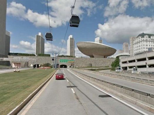
This image is from the feasibility study released last year.
The backers of the proposed aerial gondola between the Albany-Rensselaer train station and downtown Albany are surveying people this week about the idea. If you'd like to provide input, here's the online survey -- enter code "aoa" with no quotes to access it (it's case sensitive).*
The consultancy Steer Davies Gleave is conducting the survey for the McLaren Engineering Group. The survey asks about how often people travel to downtown Albany, how they get there, what they do there. And then it proposes a series of tradeoffs -- both time and price -- between transportation options and the proposed gondola. The answers will be folded into a model to help determine what sort of demand there might be for the gondola.
Representatives will also be around downtown Albany this week handing out postcards with info about the survey. And people taking the survey will be eligible for a $100 cash prize if they're willing to share their contact info at the end of the survey.
Bikes and cars, sharing the road
Because safety, and also because people often end debating this kind of stuff: The New York Bicycling Coalition has produced a video about the rules for cars -- and bikes! -- when using the road together.
The video is embedded above. It starts out with the section for cars, focusing on how bikes can use travel lanes and how to safely pass them. Then it flips to rules for bikes, focusing on practices such as signaling and (not) riding on the sidewalk. (Each segment is embedded individually below, if you'd like to watch them that way.)
The video was created in conjunction with the Albany Police Department using a grant from the state. You'll recognize a bunch of locations from around Albany.
Whatever happened to that study about the future of the I-787 corridor?
Back in 2015 there was a series of public meetings to kick off the I-787/Hudson Waterfront Corridor Study, a project intended to help plot the future of 787 from the Port of Albany north to Watervliet. The study got a lot attention because many people saw it as the first step in moving toward knocking the elevated portion of the highway.
Two years later the study is still not out. So what's up?
Studying one of the channels of the daily commuting tide into and out of Albany
New Scotland Ave and Buckingham Drive at midday.
Taxes, the budget, crime and policing -- they're all important topics that frequently come up for discussion in the city of Albany.
But if we had to guess the topic that bubbles up most often in the most places -- public meetings, neighborhood associations, online comments -- it would be this: The idea that people drive too fast and too recklessly through Albany.
On Wednesday the city announced that St. Peter's Health Partners is putting up $100k for a traffic study of the busy New Scotland Ave corridor. People who live along the corridor say it feels like traffic volumes are up significantly in recent years and that's led to congested, unsafe streets.
And while the study will just focus on this one section of the city, the situation touches on bunch of issues and challenges that are facing all of Albany.
Moynihan Train Hall construction starting
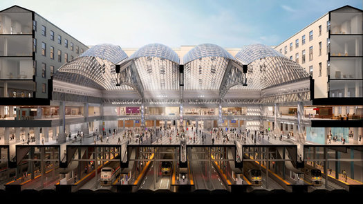
A cross section of the planned project.
The Cuomo admin announced Thursday that construction is starting on the Moynihan Train Hall, which serve as the new station for Amtrak trains in New York City. The $1.6 billion project is expected to be finished in 2020.
The train hall will be in the Farley Building -- a post office complex -- across the street from Penn Station. Former New York US Senator Daniel Patrick Moynihan proposed the trains-at-Farley idea decades ago, and there was a plan dating back as far as 10 years ago for the construction of a "Moynihan Station" on the site. Now a version of the idea is finally happening.
An underground concourse will connect Moynihan to Penn Station. The train hall will also serve the Long Island Rail Road.
This is of interest here, of course, because NYP is by far the most popular destination from Albany-Rensselaer. And Albany-Rensselaer is one of the nation's 9th busiest train station, with more than 825,000 "on offs" each year. Also: Penn Station is depressing.
Here are new renderings, along with an animated promo video....
National honor for CDTA
CDTA has been named the best mid-sized public transit system in North America by the American Transportation Public Transportation Association, a transit industry org. The local transit org announced the honor at UAlbany's Casey Stadium Tuesday.
The award is based on the span between 2014 and 2016. From APTA:
In the past three years, CDTA's ridership has been at record or near-record levels because of innovative projects like upstate New York's first [bus rapid transit] service and a successful Universal Access rider program. Additionally, bus frequencies have been increased during peak travel times to 10-12 minutes on most trunk services, a frequency that is unusual for a mid-size bus system.
CDTA joins the Toronto Transit Commission (large system) and Knoxville Area Transit (small system) in the honor.
Van Rensselaer Boulevard, on a diet
You can see the old configuration on Google Street view.
We got a chance the other day to to head over to Van Rensselaer Boulevard in Albany/Menands and check out the road diet reconfiguration there.
The state Department of Transportation paved and re-striped about one mile of the road this summer, from Northern Boulevard to Menand Road. The new configuration reduced the number of travel lanes from four to two with a center turn lane, buffered bike lanes along each side, and wide shoulders. The speed limit is now 45 mph, down from 55 mph.
A spokesman for NYSDOT says there are still a few minor details to finish up, including some signage.
The goal is to make the street -- which borders a residential neighborhood -- friendlier to pedestrians and cyclists. It was the scene of two fatal crashes in recent years, one involving a pedestrian. Neighborhood residents had been pushing for changes to make the stretch safer. [TU x2]
The Albany-Hudson Electric Trail
One of the photos from the project presentation showing a portion of the proposed route in Kinderhook.
The proposed plan for the Albany-Hudson Electric Trail -- which aims to connect Rensselaer and (almost) Hudson via a (mostly) shared-used bike path -- is out. And there's a public meeting about it Tuesday evening in East Greenbush.
Here are a few details...
A brief history of the Capital Region's much-admired light rail system
The light rail line along Madison Ave -- following an old trolley route -- has proven to be very popular, carrying students and neighborhood residents to work, shopping, and entertainment along the busy corridor. / streetcar photo: Wikipedia user Pi.1415926535 (CC BY-SA 3.0)
It's Other Timelines week on AOA, in which we'll be looking at alternate histories of this place, about big and small things that did or did not happen.
It's 2017. As the Capital Region looks back on the first fifteen years of the 21st century, it can be proud of its transit system -- and the inextricably linked patterns of land use that it has built -- even as the rest of the country debates the merit or even the very concept of public transit.
Looking back at the past eight decades, there were a few turning points -- inflection points, one might say -- at which regional leaders made choices that could have resulted in a very different future if another path had been taken.
So how did Albany, Schenectady, and Troy end up with a transit system that would be the envy of cities many times their size?


Checking out the new CDPHP Cycle bike share
The new bike share backed by CDTA -- CDPHP Cycle -- launched Thursday. You can now sign up for an account and check out a bike from one of the stations in the Capital Region's four core cities.
Here are details about how it works, and a few thoughts after trying it out.
Where to get a hybrid or electric car serviced?
Mark emails:
I've been on the hunt for a mechanic that specializes/is-well-versed in electric/hybrid cars, but have failed to bag anything.
I have taken my traditional vehicle to a shop that I am very pleased with, but I hesitate to bring this new space-age vehicle to the same place, because...well, I don't know. Am I overthinking this? Is a car just car? ...
P.S. Dealerships are sure to be the knee-jerk answer to this, but, you know, they're dealerships.
This is something we hadn't really thought about before. And the fundamental question Mark seems like a good one: Is a hybrid or electric car "just" like any other car when it comes to getting it serviced, or is there special expertise involved.
So, got experience or thoughts or a suggestion on this topic? Please share! If you're recommending a shop, a sentence or two about why you're recommending a place can be helpful.
Earlier:
+ Capital Region Recommended Mechanics
+ New York State is now offering a rebate for electric cars
Experiences with Uber and Lyft so far?
 KGB emails:
I was wondering if any of your readers have tried ride sharing locally, and if they wanted to comment on their experiences. I'm going from Albany to an event in Berne. I'd love to be able to have more than one drink (old friends, good times). Should I try?
We're curious about people's experiences so far, too -- specifically about prices for trips and wait times, and whether you picked Uber or Lyft (and why).
So, if you tried one of these services locally, please share!
Albany's sister city bike paradise
1. Nijmegen is Albany's sister city in the Netherlands.
2. And, as illustrated by the Streetfilms video above, it's also some sort of bike paradise.
Yep, the United States is not Europe, and Albany is not a mid-size Dutch city. But there are a lot of interesting bits in that video, among them the history of Nijmegen's shift toward bikes over the last handful of decades, and the idea that making a city bike and pedestrian friendly also makes it more attractive to young families and seniors.
[via]
Word(s) on the street
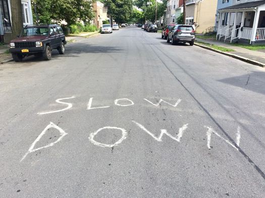
Go to pretty much any neighborhood association meeting in Albany and we're guessing the odds that traffic safety -- specifically, people driving too fast -- will bubble up as a topic are 50-50 (at least). There will be ensuing discussion. People will toss out ideas. Someone says they'll talk with the city. And so on. Then it comes back up again at a future meeting.
Anyway, we noticed that someone had taken the issue into their own hands on 3rd Street in the West Hill neighborhood.
(We're curious if that actually does make people slow down. It's hard to miss.)
Capital Region vehicle crashes by intersection
Map created by Martin, Harding, and Mazzotti.
To be clear, this is content marketing -- or, rather, Content Marketing ™ -- but this list of the "Capital Region's most dangerous intersections" from Martin, Harding, and Mazzotti includes some interesting bits about vehicle crashes and the places they happen in the Capital Region.
It also suffers from a common problem with this sort of counting up of incidents: it doesn't account for differences in traffic volumes at the various intersections.
That said, many of the intersections aren't surprises. And it prompts some good questions about road design. One that immediately came to mind: Is there a better way to configure and manage traffic along Henry Johnson. (And it'll be interesting to see if the Madison Ave Road Diet affects things at Madison and New Scotland, and/or upgrades at Central/Washington/Lark make a difference.)
Also: Maybe you shouldn't follow so close to the car in front of you.
[via TU/Emily Masters]
The new design for the Schenectady train station
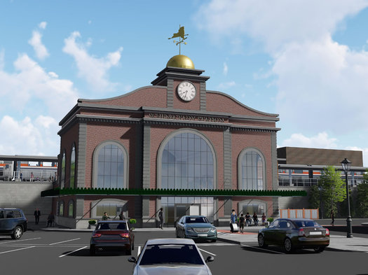
That image above is a rendering of the new train station planned for Schenectady. There are a few more renderings after the jump if you're curious.
Andrew Cuomo made a stop in the city Tuesday afternoon to reveal the design for the $23 million station. It's the second go-around for the project. You might remember that the first attempt -- announced in 2015 -- ended up having to be re-bid after the the only bidder quoted a price $10 million higher than the amount budgeted. The old station was closed last month. [Cuomo admin] [DSIC] [Daily Gazette] [TU]
This new design looks like it might be more aesthetically attractive than the first one. It's scheduled to be completed by the end of 2018.
Here's how much it will cost to use one of the upcoming bike share bikes
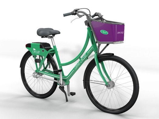
What the bikes will look like. / photo via CDTA
The upcoming bike share from CDTA -- CDPHP Cycle -- has now posted pricing info.
The base pricing for using the bikes will be $5 per hour (prorated to the minute). There's also an "out of hub" fee of $2 and a "brought to hub" bonus of $1. In other words, checking out a bike will incur a $2 fee (before any time is used) and you get a buck back if you return the bike to one of the bike share hubs. (The bikes don't have to returned to a hub. The electronic tech for the renting the bikes is on the bikes themselves, and they're equipped with GPS.)
The bike share is starting off in zones that include the cores of Albany, Saratoga Springs, Schenectady, and Troy. There's a charge of $25 for leaving a bike outside the zones.
As mentioned, that's the base rate. There are also membership plans that, like buying in volume, will make using the bikes cheaper on a per-minute basis:
Amtrak is now running some trains from Albany-Rensselaer to Grand Central
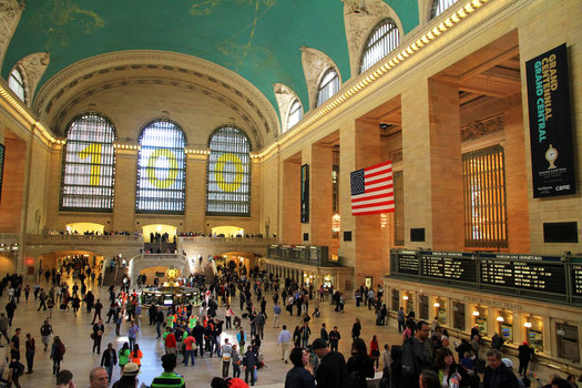
The main concourse at Grand Central. / photo: Wikipedia user Ingfbruno (CC BY-SA 3.0)
Amtrak is now running a handful of trains between Albany-Rensselaer and Grand Central in New York City, instead of Penn Station. The modified schedule will be in place through September 1.
The temporary re-routing of the select Empire Service trains is a result of the track repair work at Penn Station. A bunch of different services and lines are affected by the work, so if you're heading to NYC or connecting through it, be sure to check ahead. [NYT]
High traffic spots on the area's walk/bike trails
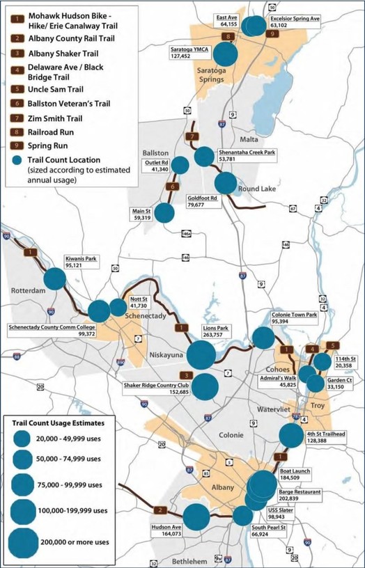
Here's a larger version. / map: CDTC
That map above depicts estimated usage at various points for the area's walk/bike trails based on survey and tracking done last year for the Capital District Transportation Committee. The full report is online if you'd like more detail and/or see how the numbers were gathered.
A few bits:
Albany testing system for paying for parking by mobile app and license plate
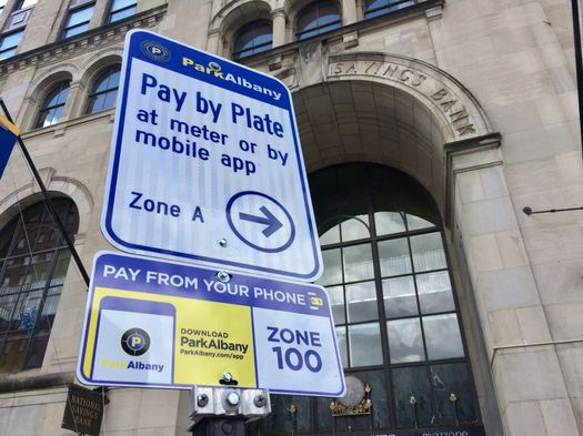
You can now pay to park in part of downtown Albany via mobile app.
The Albany Parking Authority launched a pilot program Monday to test new pay-by-app and pay-by-plate meters along State Street. The initial test includes 12 meters and covers about 100 spots on State between Eagle and Broadway.
The new system is the same one we talked with the APA about earlier this year. The idea behind the switch is to provide easier, more flexible parking options for people.
Here are a few more bits about how it works.
Electric City Trolley
Earlier this month when CDTA announced the new Capital City Shuttle service for downtown Albany, officials mentioned that they were working on a similar service for Schenectady.
And the transit org officially announced that service Tuesday: The Electric City Trolley starts this Thursday, June 22. It'll run Thursday, Friday, Saturday from 4 pm to 1 am, with pick-ups every 20 minutes at each stop. And it's free.
That's a map of the route above.
Like the Albany service, the Electric City Trolley will have realtime schedule and tracking info as part of the Cityfinder app built by Transfinder (iOS | Android). If you've already downloaded it, you don't need to do so again -- just launch the app and it will now give you the option of which city you'd like to see.
CDTA advertises on AOA.
Here are the station locations for the bike share starting later this summer
A clip from the map of Albany stations.
The new bike share that CDTA is launching later this summer -- CDPHP Cycle -- is now one step closer to starting up: The transit org has announced the locations of the stations for the bike share.
So let's have a look...
Capital City Shuttle
CDTA is staring up a free shuttle service this week that will run from the Warehouse District through downtown Albany to Lark Street. The "Capital City Shuttle" starts this Thursday, June 8 and will run Thursday, Friday, and Saturday nights through Labor Day.
"People come here without a car. People live here, who don't have a car. People work here who don't have a car. And they need a menu of options," said CDTA executive director Carm Basile while introducing the program Tuesday. "This is just another notch on our menu of options."
Here are a few more bits about the shuttle service, along with updates about the planned regionalization of taxi service and the upcoming bike share...
Services such as Uber and Lyft will be allowed to arrive a bit earlier
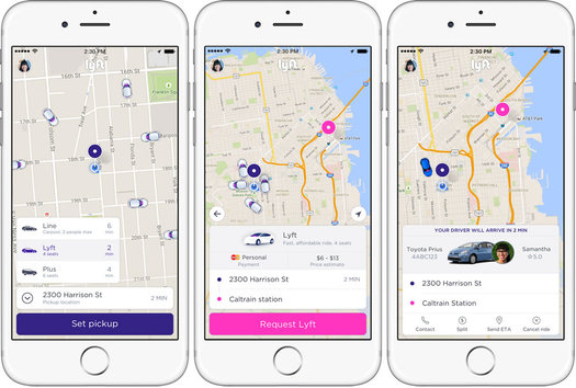
Screenshots from the Lyft app. / images: Lyft
Andrew Cuomo signed legislation Monday that pushes up the start date for allowing ride-hailing services such as Uber and Lyft to start operating across the entire state. The new date: June 29.
The original legislation opening the way for these "transportation network" companies -- as the state officially refers to them -- had the start date 90 days after it was signed. That would have put the start after the Fourth of July. The updated legislation -- which was co-sponsored in the Assembly by Pat Fahy and John McDonald, and by Neil Breslin and George Amedore in the state Senate -- was intended to get the companies started before the holiday.
The rest of the details about ride sharing legislation are the same. Here's a quick recap of some of the details.
It'll be interesting to see which ride hailing companies start service here (and when). The two giants -- Uber and Lyft -- have been actively working the issue here for years. But there are other services around the country, so maybe some other players will also jump into the mix.
Self-driving car to test in Albany
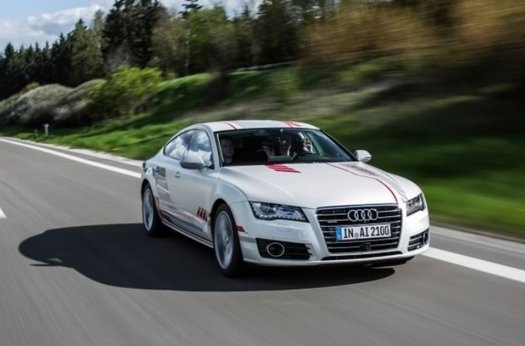
A photo of an Audi self-driving car distributed by the Cuomo admin.
Audi will begin testing of autonomous vehicle technology -- a self-driving car -- in Albany near the Capitol June 13, the Cuomo admin announced Wednesday. Press release blurbage:
Included in the FY 2018 Budget, new legislation allows for testing autonomous technology through a year-long pilot program. Audi of America Inc. was the first company to apply for the rights to demonstrate this technology in New York and the first to be approved under the program. The technology they plan to demonstrate in the Capital Region is considered to be a Level 3 in autonomous vehicle operations by the Society of Automobile Engineers, meaning it is capable of safely allowing hands-free driving at posted highway speeds, but requiring a person to take over if required. Two trained engineers will be in the vehicle to monitor the system and ensure safety, one in the front seat and one in the back seat. The vehicle has already logged thousands of miles on highways across the U.S. safely.
That "level 3" is halfway along the SAE's scale from no automation all the way up to fully-automated, self-aware vehicle that swears at you when you cut it off.
The conventional wisdom right now is that self-driving cars are The Future. And pretty much every car company -- along with companies such as the Google affiliate Waymo -- are working on the tech. (Ford recently sacked its CEO, apparently in large because a deal fell through with Google on self-driving tech.) [Automotive News]
The implications of having cars that can drive without humans opens up a range of possibilities, including greater safety and convenience. But it also raises questions about the future of public transit, how cities are designed, commuting, and jobs. [Quartz]
For example, to link this to another hot topic here: Uber has been vigorously pursuing self-driving tech, presumably to eliminate human drivers, and the cost of paying them, from the service in the future (with all the usual Uber drama). [NYT x2]
Earlier: Four trends shaping the way people will get around the Capital Region in the future
Tracking trucks in Albany's South End
South Pearl Street last summer.
People in Albany's South End have long been calling for attention and resources to focus on air quality and other environmental health issues in the neighborhood. And there's a project coming up that's using an interesting tool to study truck traffic along the South Pearl Street corridor -- one of the factors related to air quality.
The city of Albany and the Capital District Transportation Committee will be using automatic license plate readers to better understand how trucks move through the neighborhood. From a CDTC press release:
Instead of assigning people to record license plate numbers at several locations for 24 hours a day for 1-2 days, this survey will install and use automatic license plate readers (ALPRs) over a longer period of time to obtain the same data, in greater quantity with more reliability.
The goal of the survey is to identify truck travel patterns and generators, and to develop possible alternative routes. The data collected will only be used for these purposes. ...
The study area will be bounded on the north by the intersection of Green Street and 4th Avenue, on the west by South Pearl Street, on the south by the City of Albany boundary, and on the east by Smith Boulevard and Church Street in the Port of Albany. The ALPRs will be installed at 6 intersections in this area. The project is expected to be completed in September 2017 with a final report.
CDTC will be working with a company called FES Installations to study the data generated by the 15 license plate readers.
This is a different sort of use for the technology that the one for which it's been most famous in recent years: Law enforcement agencies have made extensive use of license plate readers over the past decade, scooping up huge amounts of data about where vehicles have been spotted, including here in New York State. That's prompted debates about how the tech should -- or should not -- be used, and some of the civil liberties and ethics issues involved. [Democrat and Chronicle] [TU] [The Atlantic]
Peeking at the bike share station suggestions
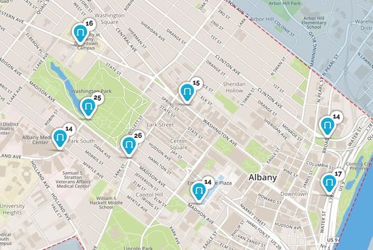
Another quick follow-up on CDTA's upcoming bike share. The online suggestion and voting for bike share stations continues to run through April 30 -- and the results are being mapped.
That's a clip of the map above. The top suggestions in Albany so far are pretty much you'd expect: Washington Park, the ESP, Lark Street, the pedestrian bridge to Corning Riverfront Park, and so on. (One location that doesn't have many votes, yet, but seems like it could be a good idea: Swinburne Park near Clinton Ave, which has a bike lane.)
It looks like the other three cities -- Schenectady, Troy, and Saratoga Springs -- could use a few more suggestions and votes for stations.
There are two more upcoming public info/suggestion events for the bike share:
April 25: Saratoga Springs Recreation Center on Vanderbilt Street - 6-7:30 pm
April 26: Albany Public Library, Washington Ave Branch - 6-7:30 pm
____
Earlier: A few more details about the upcoming CDTA bike share
CDTA and CDPHP advertise on AOA.
A few bits about the (probable) upcoming arrival of ride hailing apps such as Uber and Lyft
Screenshots from the Lyft app. / images: Lyft
As you've no doubt heard, the big blob of legislation that wrapped up the new state budget included a provision opening the way for ride hailing companies such as Uber and Lyft to start operating across New York State.
The services will be allowed to start operating 90 days after the governor signs the budget legislation. So, it's probably going to be sometime this July. And then whether the services are offered in a specific market will be in the hands of the individual companies.
The legislation sets out rules for a handful of issues that had been holding up the approval, including insurance requirements and local regulation. Here are a few bits and other stuff...
The Madison Ave Road Diet moves to phase two
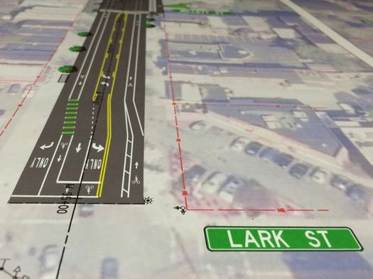
The second phase of the Madison Ave Road Diet -- one of the area's most interesting transportation projects -- is set to start this summer, and officials say they hope the bulk of the work will be finished this year.
That timeline was one of the details discussed a during a public meeting about the project Thursday evening at Saint Rose in which the city and project engineers continued to express optimism about the traffic calming plan in the face of skeptical comments and questions from the crowd.
Suggestion site now open for CDTA bike share stations, public info sessions coming up
A model of the bike share bikes. / image via CDTA
Quick follow-up to that recent post about the bike share CDTA's planning to launch later this year...
The online site to collect suggestions from the public about where the the CDPHP Cycle 20 bike stations should be located is now up and running. Blurbage:
Tell us where you want to pick up CDPHP Cycle! bikes. Use our map or download the Social Cyclist app to vote for our suggested rack locations. You can also comment on why you think it's a good spot for a CDPHP Cycle! rack. Be sure to navigate the map of your city to find suggested locations.
Decisions on rack locations will be guided with your feedback, along with the following criteria: available space, pedestrian traffic, population density, bike infrastructure, and transit options. You can also vote by downloading the free Social Cyclist mobile app, emailing cdphpcycle@CDTA.org, or calling (518) 437-6844.
Voting ends Sunday, April 30 at 11:59 p.m.
Via the suggestion site's map, there's also a peek at the initial coverage zones for the bike share in the cities of Albany, Schenectady, and Troy.
As CDTA mobility manager Bailey said in March, the overall goal of the bike share program initially will be to extend people's transportation options from nodes in the CDTA network (example: The upcoming Uncle Sam Transit Center), and to cover short-distance trips within downtowns. The second phase of the program will focus on reaching out farther into neighborhoods with additional bikes.
Public events (updated)
There are also a series of upcoming public info sessions, where you'll be able to ask questions, offer suggestions, and see one of the bikes that will be used in the system...
A look at the plan for new bus and pedestrian amenities at Lark and Washington in Albany
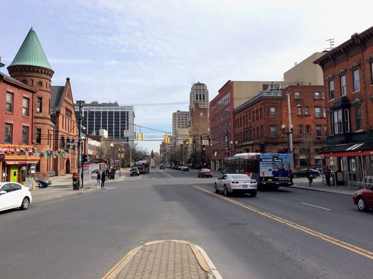
The spot where Washington Ave, Central Ave, and Lark Street run together in Albany is one of the city's busier intersections -- and not just because of cars. It also funnels many of the most popular bus routes into downtown, and it bustles with pedestrians from the surrounding walkable neighborhoods.
And this summer it's getting a bit of a makeover as part of a plan to reconfigure CDTA's facilities around the intersection.
WHAT? (airplane flies overhead)
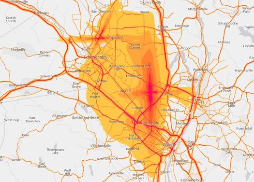
That image above is clipped from
The map colors depict estimated 24-hour sound level averages. The light yellow is about the noise level of a humming refrigerator. The magenta colors are something more like a vacuum cleaner.
You can probably guess what that cross-shaped, magenta pattern is in the middle: Albany International Airport. And if anything, for us, looking at the map both locally and across the nation highlighted the wide-ranging noise effects of airports. Those "smears" of noise along the approach and take-off paths for ALB really stick out. (And having lived inside one of those zones, yep, you definitely hear the planes as they land, especially in the summer with the windows open.)
[via NPR]
map clip: US Bureau of Transportation Statistics
Public meeting for second phase of Madison Ave Road Diet in Albany
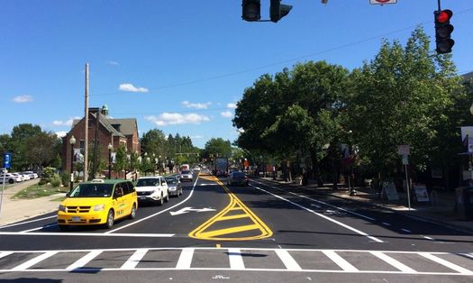
The second phase of the Madison Ave Road Diet in Albany is set to start later this year and the city has a public meeting coming up April 6 to offer info and answer questions about the plan:
Continuing the transformation of Madison Avenue into a complete street and consistent with the theme developed publicly during Phase 1, the City of Albany is now progressing Phase 2 of the project to add bike lanes, improve transit stops, and improve pedestrian accommodations on this important City Street. During this public information meeting, project representatives will provide information about the Phase 2 scope and schedule, and address questions during a brief Q&A period. Similar to Phase 1, Phase 2 proposes to reduce the number of travel lanes in the corridor from four lanes to three, upgrade traffic signals, provide signal coordination for motorists, and provide improved accommodations for non-motorized users in the corridor.
This next phase will cover the stretch from Partridge Street to Lark Street.
The lead up to the road diet prompted a lot of discussion -- from cycling advocates, from businesses expressing concerns about parking, from people who just had a hard time believing that reducing the number of travel lanes wouldn't create traffic problems. And when that first phase -- from Allen Street to Partridge -- was reconfigured, it set off a whole new flurry of comments and criticism, with city officials calling for people to be patient and adjust.
So this meeting will be a good opportunity to take a stock of how things have turned out so far. (An informal take based on our own experiences: The reconfigured section feels safer and more humane, and the transition from the new segment to the not-yet segment is jarring.)
And as we mentioned last year, this project is a test of the road diet concept. If it works out, it's not hard to see other streets getting a similar treatment.
The public meeting is Thursday, April 6 at 6 pm at the College of Saint Rose's Touhey Forum (Lally School of Education building, 1009 Madison Ave).
New York State is now offering a rebate for electric cars
The EV charging stations outside the Market32 on Madison Ave in Albany.
The Cuomo admin officially launched a rebate for electric cars Tuesday -- New York State will now chip in up to $2,000 for qualifying vehicles. That's on top of federal of a federal tax credit that's worth up to $7,500.
Press release blurbage:
$55 million of the Drive Clean Initiative is dedicated to rebates of up to $2,000 for purchase of a new plug-in hybrid electric car, all-electric car or hydrogen fuel cell car. In addition to the $55 million in rebates, $15 million will support improving consumer awareness of electric cars and their many benefits, installing more charging stations across the state, developing and demonstrating new electric car-enabling technologies, and other efforts to put more electric cars on New York's roadways. The initiative will be managed by the New York State Energy Research and Development Authority and will help the state achieve its goal to reduce greenhouse gas emissions 40 percent by 2030.
The rebate can be applied to more than 30 different models of vehicle, though the amount slides based on the all-electric range of the car. Also: If the vehicle is more than $60k, the rebate is just $500 regardless of range. (Let's face it, if you can afford a Tesla a rebate's probably not going to sway you.)
A few more details about the upcoming CDTA bike share
What the bike share bikes will look like. / image via CDTA
CDTA announced Monday that is now has a name and sponsor for its upcoming bike share program: CDPHP Cycle! (with the exclamation mark). The system is set to launch this summer.
Planning for this two-year bike share pilot has been in the works since last year, and there are now a few more details about how it's taking shape...
Siena poll: Wide support for allowing ride-hailing services upstate
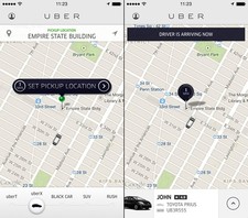 From the Siena poll out Monday: 76 percent respondents support allowing ride-hailing services such as Uber and Lyft to operate across the state.
And the proposal has widespread support, according to the poll results. More than 70 percent of respondents across every subgroup -- political, age, racial income, and so on -- supported the idea, with one exception. That group: people over age 55, in which the proposal had the support of 65 percent (and 14 percent said they didn't know or didn't have an opinion).
As you know, the issue is up again in the state legislature, and Andrew Cuomo has said he supports it.
Other bits from this Siena poll about issues such as the SUNY free tuition proposal, the Empire State Trail, Andrew Cuomo, and Donald Trump...
How we all ended up talking about a gondola between downtown Albany and the train station
Last fall the McLaren Engineering Group floated the idea of building a gondola lift to ferry people between downtown Albany and the train station over in Rensselaer. The initial phase of the project would have a price tag $16.6 million-$19.5 million. (That image is from the feasibility study.)
The concept of building a gondola or aerial tramway across the Hudson River from the Rensselaer Amtrak station to downtown Albany and the Empire State Plaza has generated a considerable amount of debate in the Capital Region over the last several months.
Readers of my previous commentaries in this space know that I'm suspicious of the need to spend tens of millions on capital-intensive infrastructure projects in the region, preferring to spread the money around to more fundamental improvements such as increased local bus service and CDTA's planned Bus Rapid Transit lines.
The gondola concept, though, presents an opportunity to consider a more basic question: Just why do quirky, perhaps absurd ideas like the gondola keep popping up in regional dialogue about transportation infrastructure?
The Albany Cutter
Sleek. / image from The Automotive Manufacturer "The Hub" (1902)
In the time before all-wheel drive: An Albany company was once famous for making sleek, luxury sleighs popular during the 1800s.
The James Goold Company, located on Broadway in downtown Albany, was one of the country's most prominent manufacturers of carriages for early trains and trolleys and streetcars. But it was the design of its sleighs -- specifically the "Albany Cutter" -- that really caught 19th century eyes.
The Albany metro fares well compared to other large metros for pedestrian deaths -- but there's room to improve
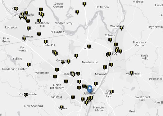
A clip from the report's map of pedestrian deaths in this area between 2005 and 2014.
The Albany metro is one of the nation's safer large metros in terms of pedestrian deaths, according to analysis out this month by Smart Growth America. Each year the advocacy org releases a report called "Dangerous By Design" that tracks and compares pedestrian deaths across the nation's 100 (or so) largest metros.
The Albany metro ranks #94 out of 104 metros in the new report's Pedestrian Danger Index -- that is, it was the 11th safest for pedestrian deaths. The index attempts to adjust the number of total pedestrian deaths per capita in area for estimates of the number of people who are walking to work. In terms of raw number of pedestrian deaths per capita, the Albany area fared a bit worse -- 23rd out of 104. (The data are from 2005-2014.)
The rankings for other New York metro areas: Syracuse (#99), New York-Newark-Jersey City (#95), Rochester (#91), Buffalo-Cheektowaga-Niagara Falls (#72). The metros pegged as most dangerous were mostly in Florida and other Sun Belt areas.
The report also ranks states -- New York ranked 38th out of 51 (including DC) for highest Pedestrian Danger Index.
From this year's report, which highlights that older people and people of color are disproportionately killed more often in crashes while walking:
CDTA's new fare smart cards are now available

This Navigator card belongs to Albany Public Library executive director Scott Jarzombek. He was at today's public roll out of the new system because APL employees -- including himself -- were using the cards during a pilot test over the past year. (APL has a universal access agreement with CDTA for employees to ride the bus.)
CDTA opened its new Navigator fare card to the general public Thursday. The new system includes a bunch of potential benefits for riders as well as the transit org -- and it opens some interesting possibilities for transportation in the Capital Region that extend beyond the bus (hello, taxis).
"It makes everything quicker, everything more convenient," CDTA CEO Carm Basile said Thursday. "But most importantly, the customer manages their own account. They do what they want to do when they want to do it and how they want do it."
Here's a quick overview, along with a few bits about the upcoming bike share and a common taxi system for the Capital Region.
The Empire State Trail
An overview map shared by the Cuomo admin Tuesday.
One of the many proposals to floated during Andrew Cuomo's ongoing State of the State tour this week is a plan to build the Empire State Trail -- a 750-mile multi-use path that would stretch from NYC to the Adirondacks and from Albany to Buffalo.
The Cuomo admin says it'd be the longest state multi-use path in the country.
CDTA: Bike share planned for next summer
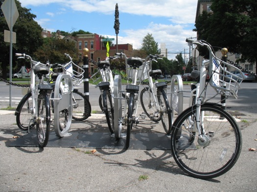
Some of the bikes used during the 2014 Capital Region bike share demonstration project.
CDTA is planning to start its new bike share pilot next summer, the transit org said Wednesday.
It was one of the details the accompanied the announcement that CDTA has selected the company Social Bicycles as the operator of the two-year pilot program. The company runs bike shares in a bunch of cities around the country.
Bike share press release blurbage:
Bike Albany Map
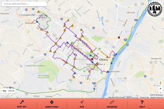
A screengrab.
That interactive map of bike-friendly routes through the city of Albany that the Albany Bicycle Coaltion has been working on is now online -- go have a look. The map/app will be formally introduced at an event at the Downtube Friday.
From a description of the project:
Objective: an online, interactive Albany bike map with bicycle-friendly routes.
Primary considerations: safety and comfort. We especially want to encourage novice riders, visitors, and new residents, by showing that you can cycle throughout Albany on mainly bike-friendly streets. The map concentrates on secondary roads, side streets, and bike-pedestrian paths. Major arteries are used only where necessary to make connections. Traffic density is indicated by color coding. Traffic advisories, where needed, are indicated by "caution" triangles.
The map includes preferred routes, bike shop locations, and there's even functions for mapping out a bike-friendly route between two places and measuring distances. It's also set up to work on mobile devices.
ABC has been working on this project with Parks & Trails New York and Mohawk Valley GIS, it was funded in party through state grant money (coordinated by local state Assembly member Pat Fahy) and local donations.
About that idea to connect the train station with downtown Albany via a gondola lift...
Maybe you remember a while back the idea popped up of constructing a gondola lift to ferry people between downtown Albany and the train station over in Rensselaer.
Well, the engineering firm that floated the possibility -- McLaren Engineering Group -- released a feasibility study Wednesday that concludes the project is workable, and "retains the potential of being a transformational project that will create a spark of increased mobility, tourism, and economic development in two areas of the cities of Albany and Rensselaer that are currently underdeveloped."
Here's a quick overview and a few thoughts...
CDTA wants to know what you think about taxi service in this area
 CDTA has posted an online survey looking for feedback and ideas about taxi service in the Capital Region. Blurbage:
The questionnaire offers an opportunity for riders to provide comments on previous experiences and what they would like to see moving forward to enhance their taxi experience.
"We see this as a chance to receive feedback on what people want to see from this industry moving forward," said CDTA Chief Executive Officer Carm Basile. We are excited to enhance the menu of mobility options across the Capital Region."
In addition to the customer questionnaire and common ordinance, CDTA will focus on adding other customer support systems, including a new web page with detailed information about local taxi services and the integration of its call center for taxi services.
We skimmed through the survey and we're guessing it would probably take most people no more than five minutes to complete.
But, you might be thinking, CDTA is the bus org -- why is it focused on taxis?
Because it's also now in position to create a regional taxi system for the Capital Region thanks to a new law that passed during the last state legislative session. The legislation allows local municipalities to opt-in to a setup in which CDTA would serve as an administrator for taxi (and taxi driver) licensing and a common complaint system. The idea is to create common standards across municipalities for taxi companies, drivers, and riders.
Or, to boil it way down, the goal is to create a common taxi system here that's less confusing and doesn't routinely disappoint people.
So this survey is one way to speak up about what you'd like to see. If past surveys are any indication, people have a lot to say about taxi service in this area.
Bike-friendly Albany map nearing finish line
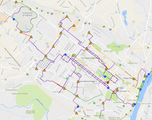
The Albany Bicycle Coalition's effort to create an interactive map of bike-friendly routes through the city of Albany is almost to the finish line. ABC has posted a preview of the map, and it's working on the interactive version.
The org says it's still looking to raise $1,500 to complete the project. Details on how to contribute are at that link above. A fully-functional test version is expected to be ready this month.
About the project:
Objective: an online, interactive Albany bike map with bicycle-friendly routes.
Primary considerations: safety and comfort . We especially want to encourage novice riders, visitors, and new residents, by showing that you can cycle throughout Albany on mainly bike-friendly streets. The map concentrates on secondary roads, side streets, and bike-pedestrian paths. Major arteries are used only where necessary to make connections. Traffic density is indicated by color coding. Traffic advisories, where needed, are indicated by "caution" triangles.
We have made many revisions the past few months, based on your input. We incorporated valuable advice from many people, and have made significant changes to many of the routes.
(As mentioned this past spring.)
Schenectady bike lane demonstration
The city of Schenectady's ongoing work toward a master plan for bike infrastructure includes a demonstration project that starts today (Wednesday) and runs through the weekend on Craig Street in Hamilton Hill that's focused on bike lanes, shared lanes, and street calming. Blurbage:
As part of the Schenectady Bike Infrastructure Master Plan, riders and residents are invited to participate in this community demonstration project showcasing street-level bicycle improvements designed to increase safety and connectivity. The temporary installation through funding from CDTC, is designed to explore bicycle-related Complete Streets options for improving Craig Street as a City, Neighborhood and Schools connection.
Here's a map and other backgroun about the project.
The demo includes a bike fest Wednesday afternoon from 2-6 pm with bike-themed activities and prizes. And the Electric City Bike Rescue will be there helping with repairs and maintenance.
This is the second demostration project as part of the bike master plan process. Earlier this year there was a demo of a contra-flow bike lane on Washington Ave.
The plan for a new NYC train station. (For real this time. Probably.)
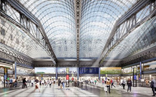
Earlier this year Andrew Cuomo floated the latest plan for building a new train station in New York City to replace the outdated and much-unloved Penn Station. The broad outline of the project included the long-planned conversion of the huge post office building across the street from Penn Station.
Now there are more specific details: On Tuesday Andrew Cuomo revealed a timeline for the project, showed more renderings, and said the project will build a "world class" train station.
(blink) pedestrian crossing (blink)
We encountered a new-to-us type of crosswalk today* and thought it was interesting because of the way it signals to drivers rather than pedestrians.
The crosswalk is near one of the new bus shelters on New Scotland Ave in Albany, just up the street from Albany Med. (It's across from the state Department of Health lab building.) The signal button doesn't trigger a traffic light or one of those walk/don't walk signs. Instead, it activates blinking lights to notify drivers that a pedestrian's crossing. (There's a photo of the crosswalk after the jump.)
And, in our experience today, it worked! Oncoming traffic actually stopped. That might not sound like much, but we'd guess the chances of traffic stopping at a similar crosswalk without the lights -- even when there's a(n often battered) sign in the middle of the street telling drivers to stop for pedestrians -- are, at best, 50-50.**
So, an early +1 for these signals. And if they don't work, maybe a giant, blinking "Stop for pedestrians -- no, really, actually stop" sign should be next.
* What, you don't get excited about that?
** Our technique for those crosswalks: Wait for a gap in traffic, then stride purposefully into the crosswalk while giving the I-see-you stare, with a hand up, to oncoming traffic. You gotta act like you own that crosswalk.
The Capital Region's transit arteries
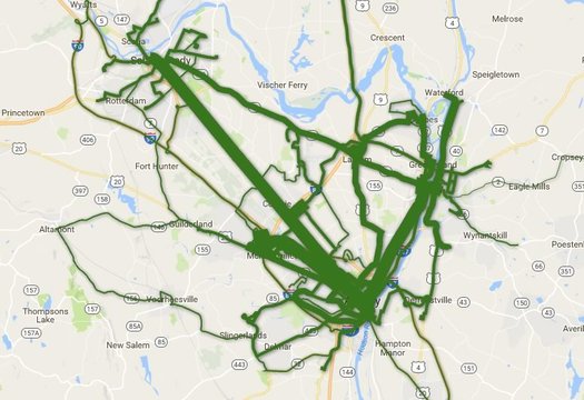
Total ridership per route during the last fiscal year. Is there a clickable, zoomable map inside? You know there is...
Which CDTA bus lines get the most riders?
The news earlier this year that CDTA set another annual ridership record -- and the recent batch of service changes on some of its most popular routes -- got us curious about ridership across the whole CDTA system.
So, of course, we had to make some clickable maps. Let's have a look.
Adapting to the Madison Ave Road Diet
Some follow-up on the roll out of the Madison Ave Road Diet in Albany...
Since the new striping has gone down on the section of Madison Ave starting at Allen Street this week, we've heard a lot of comments from people hailing the traffic calming project for slowing vehicle speeds and providing bike lanes.
We've also seen a few complaints that traffic has become very slow during the late afternoon. For example: one person said it took her 25 minutes to get from New Scotland Ave to Allen Street on Wednesday, a distance of 1.3 miles. (Though maybe there was an unusual circumstance contributing to the backup.)
So at the city of Albany's official unveiling of the project's first phase Thursday afternoon, we talked with city officials about these complaints.
They urged patience as construction continues and they work out the snags. But they also called for people to adapt.
Madison Ave Road Diet, now lined up
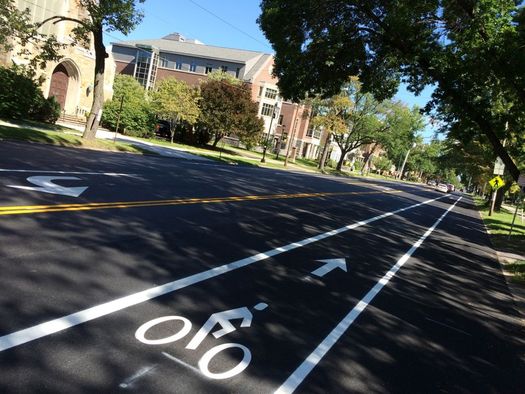
As mentioned, the city of Albany has started re-striping Madison Ave has part of the road diet in the works for the corridor between Allen Street and, eventually, Lark Street. So we took a a few minutes Tuesday to stop by the western-most section to see how it's looking.
That's a pic above, and there are more after the jump if you're curious.
The Madison Ave Road Diet is changing the street from two travel lanes in each direction to one travel lane each way with a center turn lane and bike lanes running along both sides.
The goal behind changing the road design is to "calm" traffic -- getting cars to move slower and making the corridor more friendly to pedestrians and cyclists -- with an eye toward making the street safer. A representative of Creighton Manning, the firm that's overseeing the road diet project, said at a public meeting earlier this year they're projecting a 25 percent decrease in accidents because of the redesign.
Madison Ave Road Diet striping to start, lower speed limit on Washington Ave
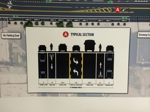
The planned new configuration of Madison Ave between Allen Street and, eventually, Lark Street.
Two traffic safety/road design things of note in the city of Albany:
Washington Ave speed limit reduction
The Albany Police Department announced this week that the posted speed limit on the section of Washington Ave from Jermain Street (basically the overpass over Rt 85) to the I-90 Exit 2 ramp will be changed from 45 mph to 30 mph as of this Friday, August 19 at 9 am.
As the department said in a press release: "The Albany Police Department will also have units on patrol in this corridor for the purposes of traffic safety education and enforcement."
That section of Washington Ave is the stretch along the the Harriman State Office Campus and UAlbany's campus. And there's been a lot of development along there over the past few decades -- the Patroon Creek office park, a bunch of hotels, and now a new private dorm across the street from UAlbany with another one in the works. The dorms alone will probably prompt some increased pedestrian activity along there. Lowering the speed limit should make the situation marginally safer. But it wouldn't be surprising if the design of the road -- currently two lanes in each direction -- eventually becomes a point of discussion.
Madison Ave Road Diet striping
Also announced this week: There will be paving work on the section of Madison Ave between Allen Street and Partridge Street this Friday. And then on Monday and Tuesday the new striping for the Madison Ave Road Diet project will be going down on that stretch.
As you might remember, Madison Ave -- currently two lanes in each direction -- will be re-striped so that it's one lane in each direction with a center turn lane and a bike lane in each direction.
____
Earlier on AOA: Designing for safer Capital Region streets
Big batch of upcoming CDTA schedule adjustments
 CDTA has a bunch of schedule adjustments set to start August 28. The transit org is touting the adjustments as "the largest set of service enhancements" it's rolled out during the last five years.
Many of the adjustments are aimed at increasing the frequency of buses. One that caught our eye right away: During the UAlbany school year, the #12 bus that runs along Washington Ave between downtown Albany and Crossgates will have a frequency of every 8 minutes from 2-6 pm on weekdays (current frequency is 10 minutes). If CDTA can keep that up, it would be a remarkably short time period between buses.
A list of the service adjustments is after the jump.
CDTA is coming another fiscal year in which it posted record-high ridership, thanks in part to the "universal access" agreements its reached with many institutions during the last few years. Ridership is up 25 percent over the last five years.
By the way: If you ride the bus and have a smartphone, it's definitely worth downloading the CDTA iRide app which has realtime projections of when buses will arrive at specific stops. (Tip: Save your frequent stops in the app's favorite stops listing. Next time you're at the stop, just punch in the code number for the stop -- it's printed on the bus stop sign.)
We use it all time, and it's become such an automatic check that it's hard imagine riding the bus without it.
How the train station ended up where it is now
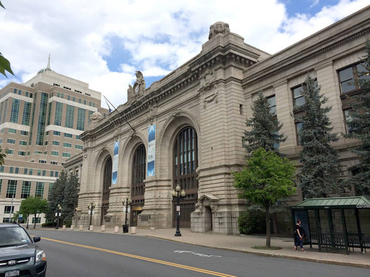
The old Union Station on Broadway in Albany (AKA, Kiernan Plaza) has since found new use as offices.
The fact that Albany's train station is over the river in Rensselaer is one of those things that prompts a lot of "What... why... huh?" reactions from people. (Even though the new version is actually pretty nice.) And it can be especially puzzling since the old train station in Albany still stands -- and is a rather grand building at that.
Over at Hoxsie, Carl recently took up this topic and it's the best account we've seen of how things ended where they are today. Here's a clip:
Those who remember Albany's Union Station as a glorious destination in the '50s and '60s most likely benefit from the rose-colored glasses of nostalgia. A 1969 column in the Knickerbocker News acknowledged that "In its dying days, Albany's Union Station was an odiferous and dingy cavern, but still, if you looked hard, you could see traces of the station's earlier grandeur." If you grew up later than the '70s, you may not be able to understand just how dingy cities were back then - between coal ash, diesel fumes, and the horrendous exhaust that came out of each and every automobile, every structure was covered in soot. Likely the exterior of Union Station had never been cleaned, and by some accounts the same could be said of the inside. ...
The Rensselaer station opened sometime in 1968, a box next to a grocery store that served as the region's rail station until 2002. That Knick News columnist who in early 1969 called Union Station "odiferous" also said that
"In contrast, the Penn Central's new Albany-Rensselaer station in Rensselaer is - with all due respect to our neighboring city - a rude comedown and a ride to the new station is a dispiriting experience. Situated at the northern edge of Rensselaer, the station is reached after a bumpy ride over narrow streets. It looks more like a small-town depot for short-haul buses than a railroad station and is tucked away in a shallow ravine as if the Penn Central were ashamed at what it had done, as well it might be. Let us hope that the railroad's new Albany-Schenectady regional station on Karner Road in Colonie has more class."
Well, one could hope.
A train station in Colonie? Yep! That's one of many interesting bits in Carl's series of three posts about the topic (they're all quick reads) -- here are parts two and three. It's a story of railroads that weren't all that interested in railroading, the midcentury planning obsession with cars, and decisions that elicited "What the...?" reactions from the start.
Earlier on AOA:
+ A miniature version of Troy and its past
+ Riding the trolley -- everywhere>
+ Thinking about high-speed rail in New York
Schenectady bike infrastructure plan survey
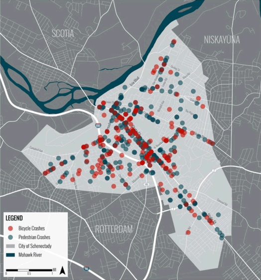
The website for the project includes includes a handful of maps that you might find interesting. The example above plots bike and pedestrian crashes around the city between 2010 and 2015. / map: City of Schenectady / CDTC / Alta / LAndArt Studio
The city of Schenectady is working toward a bike infrastructure plan and is looking for input via an online survey. Blurbage:
This plan is being developed to address the needs of all user types ranging from novice neighborhood and trail bicyclists to expert road bicyclists. Please take 5-10 minutes to fill out this questionnaire. Your response will help to build a better understanding of area needs and priorities. Even if you do not bicycle regularly, your feedback will be helpful.
The survey is pretty much what you'd expect: questions about why people bike, what would encourage them to bike more often, and priorities for making bike infrastructure upgrades.
The city is working with the Capital District Transportation Committee and Alta Planning + Design on the bike plan. (Alta is a go-to consultancy for bike projects -- it's also working with the city of Albany on the waterfront bike trail connector.)
A cookbook for designing Albany streets
An example intersection from the manual that highlights bike and transit amenities. (The example doesn't reference a specific intersection.) Here's a larger version.
The city of Albany's ongoing process to plan for a more walkable and bike-friendly future took another step forward this week with the public presentation of a draft of the city's "complete streets" manual.
And if that sounds a little wonky... well, it is. But think of it this way: The manual is like a cookbook for city streets, with recipes (so to speak) about how to incorporate elements such as bike lanes. And it's online for public review -- the city will be accepting comments July 27.
Here's a little bit more about the idea, and a few things that caught our eye while looking over the manual...
Funding for reconfiguring Washington Ave between Lark and Dove
The Cuomo admin announced a new statewide pedestrian safety campaign with $110 million for projects -- and one of the Capital Region items caught our eye:
$770,000 for a Capital District Transportation Authority project to reconfigure a one-block section of Washington Avenue in Albany between Lark Street and Dove Street to enhance safety for pedestrians, transit riders and motorists. The project will construct a travel lane exclusively for westbound left turns, consolidate six heavily used transit stops, provide a signalized, mid-block pedestrian crossing and extend curbs and revise parking to reduce speeds and traffic congestion.
CDTA has been wanting to reconfigure the bus stops there for a while (you might remember there was some outcry about how such a consolidated stop could affect the Iron Gate Cafe). It'll be interesting to see how this design shapes up. [TU+]
Info about the rest of the Capital Region projects getting money via this program is after the jump -- items include the rest of the Madison Ave Road Diet and improvements along Brandywine Ave in Schenectady.
Also: Apparently the technical term for a rumble strip is "Milled-In Audible Roadway Delineators."
Thinking about Capital Region light rail
An example of light rail in the Northeast: The MBTA Green Line near Boston. / photo: Wikipedia user Pi.1415926535 (CC BY-SA 3.0)
A couple of weeks ago I tackled the question of whether the Capital Region should build a commuter rail system, answering with a resounding "maybe... at least not yet."
As promised then, today I'm taking on whether our area should embrace a different mode of rail transit: light rail.
New York State could be closer to allowing Uber and Lyft to operate here. Maybe. Sort of.
Sample screenshots from the Uber app.
It's been more than two years since a local campaign started to get "ride sharing" services such as Uber and Lyft to come to the Capital Region. And, as it turned out, a big obstacle to those services operating here and in other non-NYC parts of the state is the way New York's laws are configured.
But now the state legislature is on the verge of removing that obstacle. Probably. Maybe.
Here's the situation -- and a glimpse at one possible related future.
Thinking about Capital Region commuter rail
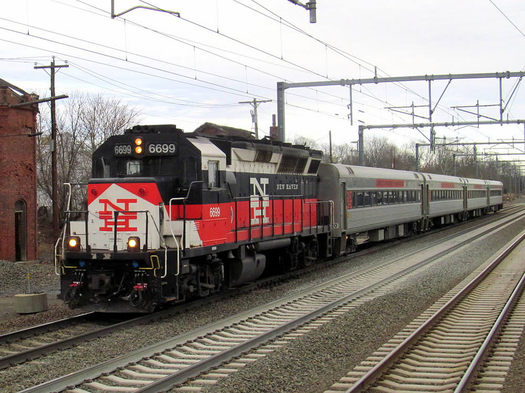
A Shore Line East commuter rail service train in Connecticut. / photo: Pi.1415926535 on Wikipedia (CC BY-SA 3.0)
The topic of bringing rail transit to the Capital District is one that comes up regularly every few years. Certainly, there are a good number of well-intentioned advocates out there in the region who believe that to have a serious transit option, the Capital District must have rail.
I don't -- at least, not yet. And here's why.
Mapping out bike routes through Albany
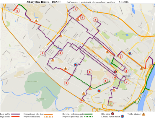
Here's the link the full-size map.
Check it out: The Albany Bicycle Coalition is putting together of map of bike-friendly streets in the city of Albany. And it's looking for help. Blurbage:
Objective: an online map of bicycle-friendly streets in the City of Albany.
Primary considerations: safety and comfort. We hope to encourage novice and first-time riders, by showing that you can cycle throughout Albany yet avoid most busy streets. The map concentrates on secondary roads, side streets, and multi-use paths. Major arteries are used only where necessary to make connections. Traffic density is indicated by color coding.
This is a work in progress, and we value your input!
We encourage you to download and print any of the DRAFT files below, and ride as many routes as you want. Your feedback will ensure that the final map is a valuable tool for the Capital Region cycling community. Please email us:
Comments & suggestions about maps - ghscom1@gmail.com
General questions & comments about this project - lorenzworden@gmail.com
The org is also breaking individual maps out in to their own maps. (The maps are at that link above.) Example: Center Square to the Hannaford on Central Ave.
ABC says it's working with Parks and Trails New York to develop an online interactive version of the map.
Designing for safer Capital Region streets
Central Ave at Quail Street in Albany.
Street safety has been a major topic of discussion in the Capital Region recently, from Albany's red light cameras to the Madison Avenue road diet to the death of a young boy in Albany and far too many others across the region. It's pretty clear that everyone agrees something must be done.
To a large extent, though, it seems that the discussion about road safety for all users has focused on more and better enforcement of existing laws as a solution to the toll. And while enforcement of speed limits and road safety -- which, in my experience, is pretty nonexistent in much of the region -- is absolutely part of the ultimate fix, the focus on it ignores that there is, in fact, a much more effective solution at hand: better design of our streets and roads.
Here are a few examples:
A gate to the past
This is Western Ave just west of Manning Blvd in 1890. Notice it's only a single lane past the toll gate? #Albany pic.twitter.com/dEI1DogXWl
— Albany Archives (@AlbanyArchives) May 4, 2016
Albany Archives posted the above pic today and it prompted one of those the-past-seems-like-a-different-place feels for us.
What is now Western Avenue out past Manning Boulevard was once part of the (First) Great Western Turnpike (we imagine some people said that as if it were italicized -- The. Great. Western. Turnpike.). It stretched from Albany to Cherry Valley more or less along the path of what's now US 20. And it was later extended to Central New York by the... Second Great Western Turnpike and The Third Great Western Turnpike.
Another year of record-high CDTA bus ridership

CDTA announced this week that it had more than 17.1 million passenger boardings during the fiscal year that ended in March -- a record high for the transit org. It's the third straight year CDTA has set a new annual ridership record.
Boardings were up 1 percent compared the previous fiscal year. And CDTA says they're up 25 percent compared to five years ago.
What's driving the increase? One big factor appears to be the increasing number of "universal access" agreements CDTA has formed with multiple organizations (such as local colleges) in recent years, under which people connected with the orgs are provided unlimited free rides. CDTA says boardings that are part of this program now make up 25 percent of all the systems rides.
CDTA ridership hit low point during the late 1990s and has been trending upward overall since then. After the jump there's a graph of the numbers from 1980 to now.
Capital Region Bike to Work Challenge 2016
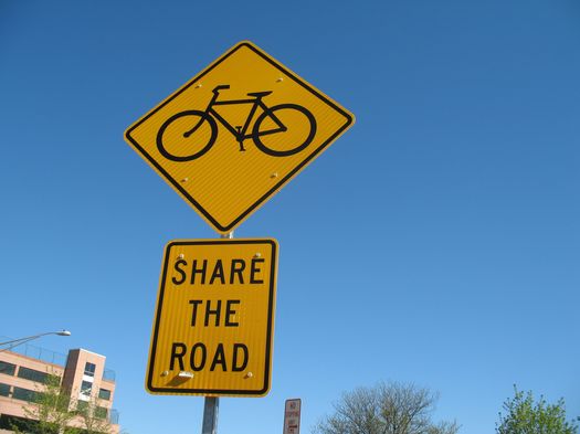
The annual Bike to Work Day is May 20 -- which means you still have some time to organize your team for the Capital Region Bike to Work Challenge.
What is this challenge? Blurbage:
Trophies will be awarded in each county for the following categories. Winners will "own" the trophies until Bike to Work Day 2017.
+ Organization with the largest number of riders
+ Small organization with the highest percent participation (20 or fewer employees)
+ Organization over 20 employees with the highest percent participation
+ Person who rode the farthest.
The challenge is organized by the Capital District Transportation Committee (CDTC), Capital Moves, and Bikeatoga. There's sign-up info at that link above.
Competition aside, this sort of event can be a good prompt to try cycling to work. For some people it's just not going to work because of distance or whatever. That said, we suspect it's a bit like riding the bus: If you don't do it often, it might seem impractical or a big hassle. But you might be surprised by how well it works out. You just have to give it a fair shot.
How many people bike to work?
Bike commuting in the Capital Region core ranges from .4 percent of adult commuters in Albany County to .1 percent in the other counties, according to the most recent Census Bureau estimates (2010-2014). That adds up to... not a lot of people -- something just under 1,000 people.
The percentages are bit higher for some of the places within the Capital Region, such as the cities of Albany and Saratoga Springs.
Here's a national list of the cities (population 100k+) with the highest percentage of bike commuters -- it includes cold-weather spots such as Cambridge (Massachusetts), Madison (Wisconsin), Ann Arbor, and Minneapolis. All of those places have rates about 4 percent. (It'd be interesting to learn more about the bike infrastructure in those places.)
Comparing transit service both within the Capital Region and beyond
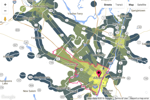
Check out the map clip above -- it's from a new site called AllTransit and it shows the number of transit routes within mile for places around the Albany-Schenectady-Troy area. (There's an interactive version at that link.) The brighter the yellow, the higher the number of routes.
AllTransit has all sorts of maps and rankings and data like this for metros all around the country. Here's a whole bunch of potential uses for info, broken out by type of person who might be using it (city residents, business owners, elected officials, and so on).
The maps might first draw your eye, but the rankings and scores are interesting for getting a bit of context about relative levels of transit services both (with)in the Capital Region and elsewhere. For example, the Albany-Schenectady-Troy metro ranks #42 among metros with more than 500k people for AllTransit's Performance Score, "an overall transit score that looks at connectivity, access to jobs, and frequency of service," with a score of 3.39. But, as you might expect, if you look within the metro area, there is a lot of variation. For example: The city of Albany's performance score is 7.8, the city of Schenectady's is 6.3, and areas of Clifton Park range from 1.4 to 0.
[via CityLab]
screengrab from AllTransit
"It is a highway, it is asphalt and concrete, we get a shovel and we hit it enough times it cracks up ... put it in a truck and there is no more highway."
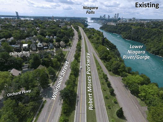
The Cuomo admin released these images for the project today (we gif'ed them). Here are more, and larger, images.
Farther afield, but maybe of note because of the ongoing 787 discussion: The Cuomo admin announced today it's directing $42 million toward ripping out a two-mile section of the Robert Moses Parkway along the Niagara River and gorge in Niagara Falls. The project will include reconstruction of a parallel street, along with new bike trails and green space. Local representatives have been pushing for the highway's removal for years. [Cuomo admin] [Buffalo News]
There are a lot of differences between the Robert Moses Parkway and 787 -- including scale. The parkway carries not quite 3200 vehicles a day, according traffic volume estimates. The segment of 787 just north of the South Mall Expressway carries almost 46,000 vehicles.
But if you're a tear-down-787 person, some of the remarks Andrew Cuomo made today might make your ears perk up.
Here's the plan for the Madison Ave Road Diet
Standing at Madison and Main ahead of Wednesday night's meeting.
The city of Albany has made a choice of which direction to go on the much-discussed Madison Avenue Road Diet, a plan to calm traffic along the busy corridor in an effort to make it safer -- and, at the same time, friendlier to pedestrians and cyclists.
The long-developing project has recently been getting more attention because of a push for the inclusion protected bike lanes in the road re-design. A coalition supporting the idea has argued the lanes are both safer for cyclists and feel safer, which would lead to more people cycling.
Consultants for the project explained the reasons for the selected choice at a public meeting Wednesday evening at Saint Rose. So, without further ado, here's the selected plan.
Meeting to talk about two alternatives for the Madison Ave Road Diet
The city of Albany has a public meeting set for March 9 at Saint Rose to discuss options for the Madison Ave Road Diet. As you know, that's the project to reduce the number of traffic lanes along the corridor and, perhaps, add some sort of bike lane.
Blurbage from the meeting flyer:
The City of Albany is progressing a Locally Administered Federal Aid project to design and construct a road diet along Madison Avenue from South Allen Street to Lark Street. The project will reduce the number of travel lanes, while improving bicycle accommodations and completing all work between the existing curbs. The purpose of the meeting is to review concepts and trade-offs for two feasible alternatives and to obtain public input on the preferred Complete Streets solution.
Update March 7: From a new press release from the city Monday: "The meeting will present the preferred Complete Streets alternative, including the selected bicycle infrastructure."
The path to this point hasn't been a straight line. After the city presented five options for the road diet last summer, it scheduled a public meeting last November to present proposed plan -- and then the meeting was cancelled.
One of the most vocal groups leading up to road diet decision was a coalition pushing for protected bike lanes along the corridor -- these would lanes that are separated in some way from car traffic, either by some sort of barrier or parked cars. The argument for these lanes is that they are not only safer for cyclists, but they also feel safer, encouraging more people to bicycle. The argument against is that they could cut into the number of parking spaces available and would be more costly to maintain.
It appeared at the time, based both on the earlier public presentation and unofficial word circulating, that the city was probably leaning toward "regular" bike lanes rather than protected bike lanes. But then the meeting was cancelled and the city said the road diet was getting further review.
So... it'll be interesting to see which options are presented at this meeting -- and the arguments made for and against those options.
The public meeting is Wednesday, March 6 9 at 6:30 pm in the Lally School building (1009 Madison Avenue) at Saint Rose.
Earlier on AOA: A new pitch for protected bike lanes in Albany
The South Mall Expressway set for a rehab
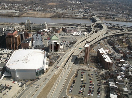
The South Mall Expressway viewed from the Corning Tower
The Cuomo admin announced this week that $22.4 million will be spent rehabbing the South Mall Expressway, which connects I-787 to the Empire State Plaza. Work is scheduled to start later this month.
Press release blurbage:
Work on the South Mall Expressway, which carries approximately 21,000 vehicles each day, will occur from I-787 to inside the tunnels underneath the Empire State Plaza. The project will include replacing the concrete driving surface of the four bridges that carry the expressway over 787 and city streets. Work will also involve structural repairs to the bridges, including joint and bearing replacements. Repairs to the pavement leading into the tunnel, work on the connecting ramps and bridge painting and steel repairs are also included in this project.
The project is scheduled to happen in stages -- the westbound side (toward the ESP) this year, the eastbound side (toward 787) next year, and then work under the bridge in 2018. Also: "Consistent with Governor Cuomo's Driver's First initiative, the project has been designed to minimize impacts to expressway traffic. Work that will most affect travel lanes has been scheduled for summer months, when traffic volumes are lower."
He's never going to leave her
The future of 787 is always a hot topic because a lot of people see the highway's placement and shape as a barrier -- between Albany and the riverfront, between downtown Albany and the South End. And if you compare aerial photos of Albany pre-South Mall Expressway and after, you can see the huge path the road plowed through downtown.
The potential impact of bus rapid transit
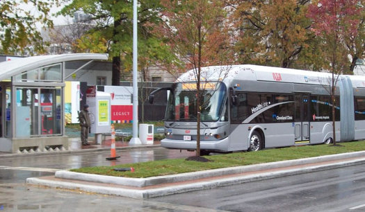
Cleveland's HealthLine was rated one of the highest quality BRT lines in the nation for its incorporation of multiple BRT features. / photo: Wikipedia user GoddardRocket
Whenever the topic of public transportation comes up around here, there's often a clamor for some sort of light rail. The reasons for that are probably an interesting topic all on their own. But one some level, it doesn't matter -- because building out a light rail system is probably not going to happen anytime in either the short or medium-term future because of cost.
But the Capital Region is moving toward a system that's more than "just" the bus: CDTA is working to build out bus rapid transit (BRT) -- BusPlus. There's already the line that runs along Route 5 between Albany and Schenectady. And CDTA is trying to pull together the funding for two more lines: one that would run along Western/Washington corridor (including UAlbany, SUNY Poly, and Crossgates) and another that would connect downtown Albany/Watervliet/Troy/Cohoes/Waterford via Route 32.
Of course, one of the criticisms of bus rapid transit is that it's actually more "bus" than "rapid transit."
But a new study concludes that BRT appears to have prompted small but significant differences in a handful of cities around the United States. Specifically, BRT stations appear to be attracting jobs (especially higher-wage jobs, perhaps pushing out lower-wage jobs), higher rents for office spaces, and more multi-family building development compared to other similar spots without BRT stations. They also found that BRT appears to be lowering transportation costs for nearby households.
What if tearing down I-787 could actually improve traffic?
The future of I-787 often pops up in conversations about downtown Albany - specifically, the desire that many people apparently have to see the elevated highway torn down.
There's a currently a longterm effort by a group of state and local agencies to study this overall topic. And you're probably already familiar with some of the potential benefits the tear-it-down crowd touts: A boulevard replacement would reconnect the city with the waterfront. It could improve air quality, especially in some underprivileged areas. And it could open up considerable portions of land for development.
Of course, one of the counter arguments is that 787 is necessary to handle the large amounts of traffic that flow into Albany each weekday, and tearing it down would tip downtown into traffic gridlock.
But what if it was just the opposite -- what if tearing down 787 could actually make traffic in Albany flow more smoothly and efficiently?
A new pitch for protected bike lanes in Albany
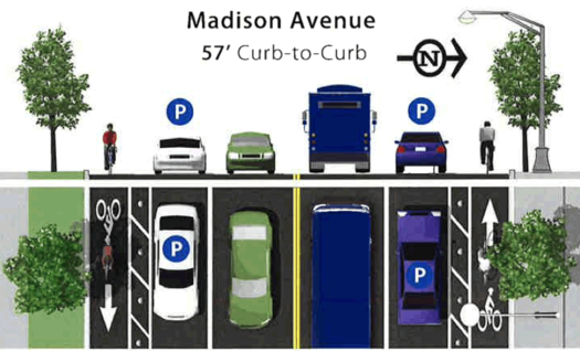
A possible future for Madison Ave?
Back in November the city of Albany was set to present the much-awaited plan for the Madison Ave Road Diet. And then, just a few days before the public meeting to announce plan, the city canceled the announcement and there's been no public word since then about what's up.
There are a bunch of interesting ideas wrapped up in the road diet, among them that the city can reduce the number of travel lanes to slow speeding vehicles while at the same time maintaining overall volume and flow of the corridor. But the idea that's gotten the most attention is the possible inclusion of protected bike lanes -- both from advocates who say the lanes would be a big step forward in the city's effort to become friendlier to cyclists, and from skeptics who worry about the cost of maintaining the lanes and their effects on the number of parking spaces.
It's hard to say what exactly is holding things up. A spokesman for mayor Kathy Sheehan told us this week that the city is still gathering info from its consultants on the project and there weren't any new developments. But there's a sense among cycling advocates that the bike lanes are probably a sticking point.
So now those advocates have a new pitch that is, essentially, the city should do an experiment.
Roundabouts... they're everywhere
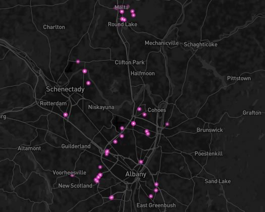
Something loopy for Friday afternoon: A map of all the roundabouts in the Capital Region -- and the world.
If click that link you'll head over to Mapbox where there's a movable, zoomable map. (The roundabouts are marked according to designations made in the OpenStreetMap.
Roundabouts have become pretty common in this area. There's Malta, of course. But they've also popped up in a lot of cities as towns, such as Colonie and Bethlehem.
While you're checking out the map, be sure to zoom out far enough so you can see Europe, especially England and Belgium.
There's research that indicates roundabout are safer than traditional "T" intersections, and they're also said to be more environmentally friendly because they cut down on the amount time vehicles spend idling at intersections.
(Thanks, Katy)
screengrab from Mapbox/OpenStreetMap map
The plan for a new Penn Station
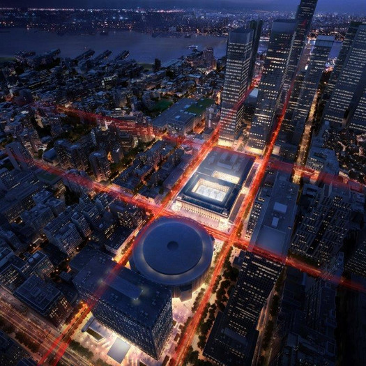
The train station would move across the street at the new Empire State Station. (The names Starkiller Base and Death Star were already taken.)
Andrew Cuomo's Tour of Major Infrastructure Project Renderings leading up to next week's State of the State power point address yesterday laid out his admin's plan for redeveloping Penn Station. And that's of interest here because NYP is the destination for so many train rides out of Albany-Rensselaer.
Cuomo is proposing a two-part plan for the Penn Station redevelopment: moving the train station portion of the facility across 8th Ave to a new station at the current post office building there, and then redeveloping the current Penn Station space as a subway hub. And there would be a new name for the two-part complex: Empire State Station.
Here are a few more bits and some renderings...
This is totally why we haven't gotten any snow yet
Check out our new tow plows. The tow plow attaches behind a snow plow & can swing out to clear two lanes at once. pic.twitter.com/FhlBz8kxe3
— NYSDOT (@NYSDOT) December 22, 2015The state Department of Transportation unveiled new snow plows today that can clear two lanes in one pass. Press release blurbage:
The tow plows attach as trailers to the back of the large dump trucks traditionally used as snow plows. The tow plow can be hydraulically adjusted to swing out to the side of the truck, doubling the plow width and giving operators the ability to simultaneously clear two travel lanes at once. The tow plow offers a greater range of motion and better operator control than standard wing plows.
The tow plow, used in combination with a 12-foot front-mounted plow, helps clear 24 feet of road at once. Two cameras assist operators and reduce blind spots. For the safety of other vehicles on the road, tow plows have a rear lighting package that mimics the lights of the truck body.
Two thoughts about this:
1. These tow plows look like they'll be useful in Mad Max: Beyond Utica.
2. This is why we haven't had any snow this so far this winter. It's like buying a fancypants new snowblower and then only getting a month of flurries -- but on a statewide level.
Ditch Your Car Sweepstakes
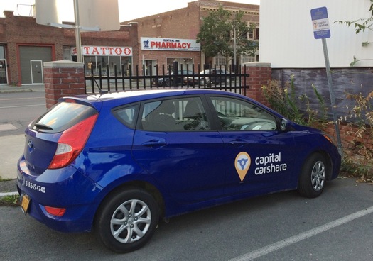
The Capital CarShare vehicles each have names -- we're pretty sure this one is "Huybertje the Hyundai."
Capital CarShare is currently running a "Ditch Your Car Sweepstakes." Blurbage:
Capital CarShare wants to give two lucky Albany residents the chance to ditch their car and still drive one (or 8) too! Whether you've recently given up a car and are struggling to get around or have a vehicle that is digging a hole in your wallet we invite you enter this sweepstakes. Here's what we're offering:
One year of FREE Gold membership ( a $300 value + no application fee!)
$500 in driving credits to get you started on your reservations
A year's worth of bus passes from CDTA for the times when using transit is a better option for your trip
The winners will be featured in a monthly blog to document their experiences over the course of the year.
There are a handful of rules involved with the contest, so be sure to review them carefully if you're interested. The situation isn't going to work everyone, but if you've been thinking about giving up your car -- or if you and a partner have been thinking about becoming a one-car household -- this could be a good opportunity.
AOA is a media sponsor of Capital CarShare.
Arguing the case for protected bike lanes
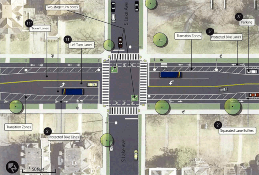
One of the coalition's two preferred options for the road diet.
At some point in the near future the city of Albany will be releasing its plan for the Madison Ave Road Diet, an effort to reshape the traffic flow a long a large portion of the Madison Ave corridor.
Bike lanes are expected to be part of the plan, and exactly what sort of bike lane has become a hot topic -- "regular" bike lanes separated from car traffic by a stripe on the road, or "protected" bike lanes that are separated by some sort of barrier (such as parked cars or vertial pylons).
Listening between the lines this past summer when the city and its consultants presented the options for the road diet, it sounded like the city might be leaning toward regular bike lanes because of concerns about the impact on the number of parking spaces and the costs associated with clearing snow. And ahead of a meeting that had been scheduled for last week (and was then canceled) to release the plan, word was circulating that the city would be heading in that direction.
Perhaps in an attempt to make a pre-emptive case, a group called the Albany Protected Bicycle Lane Coaltion released a report today that attempts to head off some of the arguments against protected lanes.
So, let's have a quick look.
City of Albany to present Madison Ave Road Diet recommendations
Update: The meeting has been cancelled, according to the Albany Police Department (traffic engineering is part of the APD), and will be rescheduled. [APD FB]
____
The city of Albany has a public meeting lined up for Monday, November 9 to present the recommendations for the Madison Ave Road Diet. The meeting is at the College of Saint Rose's Lally School Building (1009 Madison Ave) from 6-7 pm.
The Madison Ave Road Diet is a project to reconfigure the lanes on the busy thoroughfare with the aim of calming traffic and making the street more friendly to pedestrians and cyclists. That could involve reducing the number of traffic lanes from the current two in each direction, to one in each direction with a turn lane.
The part of the project that's gotten the most attention lately is the possibility of the addition of protected bike lanes to the corridor.
A few more thoughts about the push for Uber, Lyft, and similar services upstate
Sample screenshots from the Uber app.
The ongoing campaign to open the way for taxi-app services such as Uber and Lyft to operate in Upstate New York got another push this week when Uber publicly backed the campaign at the Capitol, framing it in part as a jobs and economic development issue. [NYT]
A bill that addresses insurance and regulatory issues for these sorts of "transportation network" companies has been floating around the state legislature since last session. Lyft has been pushing for legislation like this since at least this past spring. And this past summer Andrew Cuomo made comments that sounded like he supported some sort of statewide regulation. [NYS Senate] [NY Observer]
We touched on the taxi service/Uber/Lyft situation a bunch of times already. So here are a few more bits and thoughts prompted by Uber's actions this week...
When bikes weren't just something on the side
A 1900 map of "side paths" -- bike paths -- around the greater Albany area.
That recent post about the "great popularity of cycling" in Saratoga Springs around the early 1900s and the all the discussion of late about building protected bike lanes in Albany got us looking into the history of bike paths. And, as so often is the case, the past seems like a completely different place.
For example: There was once a law in New York State that allowed a group of just 50 bicyclists to petition for the formation of a commission that would be tasked with building bike lanes.
Where the commuters are from
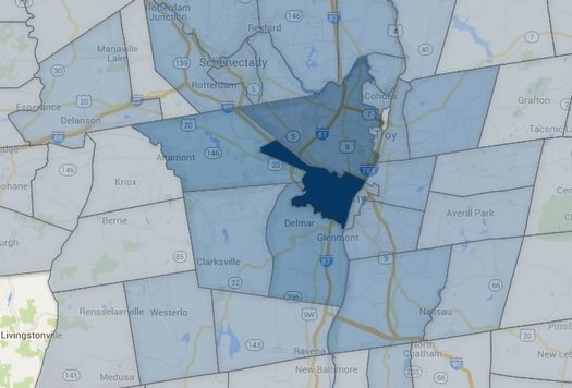
The city of Albany draws commuters from a wide area.
Each weekday in the Capital Region a large tide of people wash into the area's urban centers for their work days, and then stream back home. So large is this tide for the city of Albany that its daytime population during the week rises by 2/3.
So, where do all these people come from? Well, thanks to some recently released Census data, we can some sense of an answer to that question. And to extend the water metaphor a bit further, we can map out the "commuter sheds" that drain into each of the Capital Region's urban centers each weekday.
So let's have a look.
Options for the Madison Ave Road Diet
Could it stand to lose a lane or two?
Can Madison Avenue in Albany's Pine Hills neighborhood be a better version of itself, one that both moves cars along but also provides a safer, more comfortable experience for cyclists and pedestrians?
That's the question at the heart of the proposed Madison Ave Road Diet, one of the region's most interesting transportation projects -- and a high-priority focus for cycling advocates pushing for protected bike lanes. Wednesday night at the College of Saint Rose city officials and consultants unveiled the menu of proposed options for reconfiguring the thoroughfare.
"It's most important that we get it right," Albany mayor Kathy Sheehan told the crowd Wednesday in emphasizing the importance of public feedback on the project. "We're really going to have one opportunity and then this will become the model for what we do in other parts of the city."
Here's the menu of options, along with a few thoughts...
Three thoughts about the push for protected bike lanes in Albany
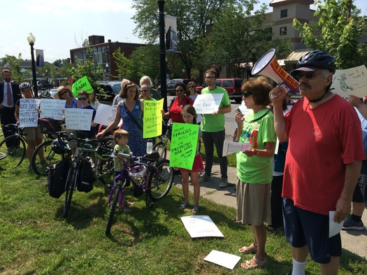
The rally in Albany this week for protected bike lanes.
This Wednesday is a big day for one of the most interesting transportation projects in the Capital Region because the city of Albany will be publicly presenting options for the Madison Ave Road Diet. The range of options will be on display, and public comments collected, at the College of Saint Rose Wednesday at 6 pm.
The project is aiming to make the popular thoroughfare through Albany's Pine Hills neighborhood safer by reducing the number of lanes in an effort to "calm" traffic. It's a notable example of how the thinking about the way people get around is evolving from a perspective that places a high, almost sole, priority on cars, to an approach that intends to be more friendly to pedestrians and cyclists.
The Madison Ave Road Diet is also potentially important because it could end up including the first protected bike lane in the city of Albany -- that is, a lane designated for bikes that's protected from car traffic by some sort of barrier. Cycling advocates have been pushing for such an amenity, and see it as a significant step towards more bikeable city.
Here are three thoughts about the push for protected bike lanes.
To Athens by ferry
Ahead of the Rail, River, Hudson II tour this coming weekend, we have a series of posts focusing on the Hudson River this week.
Last summer, in anticipation of AOA's Rail, River Hudson trip, I made the case that "How you get there matters, because getting there is half the fun." This time around, I'll add that getting there by boat will make any location feel more exotic.
Here in the Capital Region we have a few cruise boats that offer roundtrip sightseeing and/or party cruises (like the Dutch Apple II in Albany, The Captain JP II in Troy and the The Caldwell Belle in Schuylerville). These are all great ways for the public to experience our rivers by boat. But except for special events, these local cruisers are rarely used for commuting between destinations. And while there's been a lot of talk over the years of bringing water taxis to Albany, we're still waiting to see that happen.
You don't have to go too far downriver, though, to find public water transit. For the past three years, the Hudson-Athens Ferry has been carrying people between that city and village, across the Hudson River.
Two weeks ago, I finally made it onboard with a fellow traveler from Troy. Here are a few notes from our adventure...
River Week is sponsored by: Albany County Convention and Visitors Bureau, Downtown Albany BID, Dutch Apple Cruises, Harmony Mills, Hudson River Greenway, Nine Pin Cider, Sweet Sue's, and Downtown Troy BID.
Four takeaways from the kickoff for the study about the future of I-787
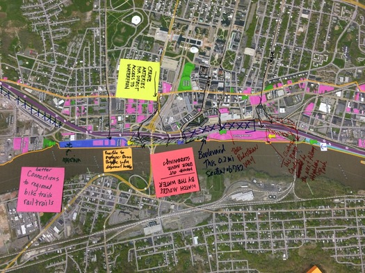
A large map was laid out so members of the public could annotate with ideas.
The planning project for the future of I-787 -- and the waterfront -- got off to its public start Wednesday with presentations at the Albany Public Library.
The I-787/Hudson Waterfront Corridor Study is sponsored by Capital District Transportation Committee, the state Department of Transportation, and the city of Albany. Its focus extends from the Port of Albany along the riverfront north to Watervliet. And its aims include helping develop strategies for improving waterfront access and guiding future transportation planning.
We stopped by for the early presentation (the same presentation was to be repeated in the evening), and took some time to check out the various posters and other "visioning" materials.
Here are four impressions/takeaways...
The Purple Line
The idea of dedicated road for the proposed BusPlus "purple" line along the Western/Washington corridor has come up here a few times. And, if you're anything like us, it's easier to get a picture what that could look like by... actually seeing a picture.
So, check out the video embedded above -- it's a CDTA promo video that shows how the dedicated busway through the Harriman State Office Campus, UAlbany uptown campus, Crossgates would work.
The purple line is one of two new BusPlus routes for which CDTA is trying line things up -- the other is the "blue" line, which would run between Albany and Waterford along the river. CDTA recently announced it's moving ahead with detailed planning for the new lines.
By the way: Watching that video about the dedicated busway, we couldn't help thinking that maybe it'd be possible to build a protected bike lane alongside that corridor.
[via TSTC]
Earlier on AOA:
+ Planning for how we'll all get around the Capital Region in the future
+ A few more bits about the proposed BusPlus Washington-Western line
Planning for how we'll all get around the Capital Region in the future
If our future overlords will be self-driving vehicles, it's probably a good idea to have a plan fo them. (If only so we can properly welcome them.) / photo: Google
A bit of follow-up to that discussion about trends that are shaping the way people get around the Capital Region: The Capital District Transportation Committee has a couple of public meetings this week to go over the draft version of its New Visions 2040 Plan -- this is the map (of sorts) for thinking and planning all sorts of regional transportation stuff, including roads, bridges, traffic congestion, CDTA, bike lanes, car sharing, road diets, even stuff like self-driving cars.
The meetings are:
+ Tuesday, June 16 at the Empire State Plaza (Meeting Room 6, Concourse Level) from 6:30-8:30 pm
+ Thursday, June 18 at Niskayuna Town Hall from 6:30-8:30 pm
The full draft plan is online if you'd like to have a look (there's also an executive summary and listing of key recommendations.) If you're curious about any of the topics mentioned above, you'll probably find at least a few interesting bits.
After a quick read through, here are a handful of things that caught our eye:
Workshops on the future of I-787
The planning project for the future of I-787 -- and the waterfront -- has a pair of public workshops lined up for later this month. As the flyer for the events says: "Help Us Visualize the Future of the Corridor."
Expanded blurbage:
Join us at one of two public workshops on June 24th in Albany or June 30th in Watervliet to discuss the future of the I-787/waterfront corridor. The purpose of the workshops is to introduce the study and its objectives, to share information on existing land uses and the transportation system and to provide opportunities for input on short and long term transportation and land use strategies.
Along with a brief presentation, workshop attendees will be able to view study area maps and data, can offer initial input on strategy and evaluation criteria and can participate in a hands on "map your ideas" station.
The first workshop is June 24 at the Albany Public Library main branch on Washington Ave from 4-7:30 pm (with presentations at 4:30 pm and 6:30 pm).
The second workshop is June 30 at the Watervliet Senior Citizen Center (1541 Broadway) from 5-7:30 pm (presentation at 5:30 pm).
The I-787/Hudson Waterfront Corridor Study is sponsored by Capital District Transportation Committee, the state Department of Transportation, and the city of Albany. Its focus extends from the Port of Albany along the riverfront north to Watervliet. And its aims include helping develop strategies for improving waterfront access and guiding future transportation planning.
Whenever we ask people here at AOA about things they'd like to see changed about area, 787 gets mentioned. A lot. So this could be a good opportunity to get your concerns and ideas on the record with planners.
Furthermore: A lot of cities have been facing the issue of what to do with their urban (often elevated or waterfront) highways. Just down the Thruway, Syracuse has been trying to sort out what to do with I-81, an elevated highway that runs right through the middle of downtown, a process that's included conflict between the city and its suburbs. (Here's the latest on the I-81 storyline.)
As part of the planning process for the next I-81, the Syracuse Metropolitan Transportation Council put together a bunch of case studies about how other cities have handled remaking urban highways -- it's worth a look if you're interested in the topic.
Speed bumps for Washington Park?
Alison emails with a question that's not exactly an Ask AOA question so much as an idea:
Should there be speed bumps in Washington Park? People often fly through there like it's the highway, which is really unsafe for everyone who uses the park. A couple years ago, I was there when a dog ran into the street and was hit by a car going way too fast. The dog should not have darted out in front of traffic of course, but in a park these things can happen, and wouldn't it be best if people were driving like they were in a crowded park full of kids, bikers, walkers, and pets?
The 'driver must stop' signs in the crosswalks aren't really working, and drivers often speed up to avoid having to stop when they see someone trying to cross. So, speed bumps in the park...friend or foe?
Alison's idea reminded us of something Albany Bagel floated earlier this year (in addition to speed bumps): car-free Saturdays in Washington Park.
For whatever reason, car/pedestrian interactions have been a frequent topic of discussion in Albany in recent years. (Whether that's a result of increased issues or increased awareness is a good question.) And city leaders have said the push for red light cameras grew out of hearing neighborhood groups consistently express concerns about traffic safety issues.
So, thoughts on whether this is a step in a good direction?
A few facts, controversies, and quirks from the Northway's history
As you know, the Twin Bridges' official name is Thaddeus Kosciusko Bridge. (Kosciuszk-who?) / photo: Nicholas Hepler at Wikipedia (CC-BY-2.5)
As noted by Albany Archives, the section of the Northway from Albany to around Glens Falls officially opened this week in 1961 (that is, Nelson Rockefeller cut a ribbon).
That got us rummaging through the history of the Northway -- ahem, excuse us, The Adirondack Northway -- and here are a few bits you might finding interesting...
How to reliably arrange transportation for a small group of people?
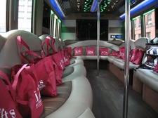 Chris emails (emphasis added):
With all the talk these past few weeks about Uber/Lyft and the state of cab transportation in the region, I have a more practical question. We live in Albany, and we have tickets for the Capital Region Brewcycle Tour in Troy. It looks great and we can't wait to check it out! We want to enjoy it AND get home safely. A DD is always the responsible default option but we're comfortable leaving a car in Troy overnight. All told, there will be 6 of us needing to get back. There would be one pick-up sometime around 12-1230 [at night] in Troy and 1 or 2 stops for drop off in Albany.
If I know when and where I need a pick up a week in advance, exactly how many people I have to transport and where we need to go, what is the best option out there? Is there a private car service that readers have used and would recommend? What was the cost? Is the state of cabs in Troy any better than Albany? Is there a good one that could accommodate 6 people?
Basically we're looking for a service that would get us home:
1- safely- not too interested in some some dude with a van who has a lot of free time
2- reliably- don't want to be stuck waiting on a street corner for someone to show up eventually
3- economically- I know a limo would work, but it seems terribly excessive and expensive for what amounts to about 25 minutes and 10 miles of driving.
With the advantage of being able to make arrangements in advance I'm hopeful we can find something reasonable. I'd be willing to leave a deposit or pay in advance to secure something.
Any advice would be much appreciated. Thanks!
Got a suggestion for Chris and friends? Please share!
Trains great and otherwise
 Over at National Journal there's an interesting article looking at why the state of passenger rail service in the US is often underwhelming. Here's a clip that reminded us of a lot of discussions regarding public infrastructure here in the Capital Region:
The Gulf situation is a miniature version of the chicken-and-egg question that bedevils Amtrak as a whole: Is it a waste of money because there isn't sufficient demand for trains? Or is there insufficient demand for trains because we haven't spent the money to create a great rail system? Outside of the Northeast Corridor, the tracks Amtrak uses are almost all owned by freight railroads. CSX, Union Pacific, and a handful of other behemoths naturally hog them, which contributes to Amtrak's chronic tardiness, which in turn dissuades passengers from taking Amtrak. As a result, Congress cites Amtrak's low-ridership numbers as a reason not to grant it larger subsidies, which of course are exactly what Amtrak would need in order to purchase its own train tracks. Commenting on the vicious cycle, [former Amtrak chairman] John Robert Smith says: "You can't disinvest in something and then beat it to death because it doesn't perform."
There's already relatively strong demand for train service in the Northeast, and Albany-Rensselaer is one of the busiest stations in the whole system. But if you could hop a high-speed train from here and reliably arrive at New York-Penn in, say, an hour and a half -- what might that do for ridership?
And the same goes for other sorts of transportation systems. What if the Capital Region had a bus rapid transit system that was truly rapid and worked more like a subway system than a bus? What if people felt good about the state of local taxis? How would that affect demand for those modes?
Anyway, that National Journal article includes some interesting bits about funding for Amtrak, some floated proposals for private high-speed rail in other parts of the country, and how political support for trains is maybe a bit more nuanced than you might expect.
Earlier on AOA: Thinking about high-speed rail in New York
[via MeFi]
People are riding the bus more often
CDTA announced this week that is had more than 17 million boardings in the fiscal year that ended this past March -- that's the highest total in the transit org's history. And it's the second straight year that CDTA's ridership number has set an all-time record.
The org reports that ridership is up 23 percent over the last five years. And a large chunk of its ridership now falls under "universal access" agreements it's struck with local colleges and employers during the last few years. CDTA says riders using the system under these agreements represented more than 4 million boardings last year.
So, put simply, people are riding the bus more often.
We were curious for some historical context, so we got a hold of CDTA ridership numbers over its history and did a few comparisons...
Albany red light camera program set to start soon
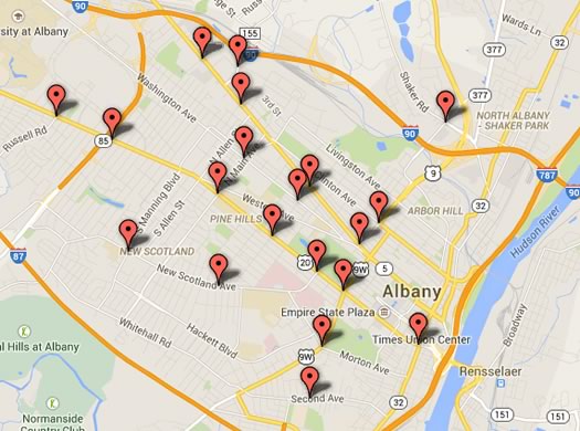
The previously announced intersections that are set to get cameras.
The city of Albany's red light camera system will start operating within the next two months, the Albany Police Department said Friday as part of an announcement about the selection of vendor for the system.
The city has picked GATSO USA to provide the equipment for the 20 intersections that will get cameras as part of the new system.
A couple of key details from the announcement:
Alongside the push for Uber
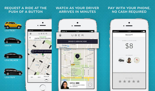
Screenshots from the Uber app.
The open letter that Matt Baumgartner and Vic Christopher released Tuesday calling on local mayors to help bring Uber to the Capital Region has been getting a lot of attention in the local media. And that makes sense. Baumgartner and Christopher are both prominent local business figures, and it's no secret there is ample frustration with local taxi services.
But the taxi issue in the Capital Region has been simmering for a while (Baumgartner and Christopher first reached out to Uber more than a year ago.) And there are a handful of important to angles to keep in mind...
Charting a return for steamship trips on the Hudson
 A group is aiming to bring back steamship service on the Hudson River between New York City and Albany by restoring a century-old ship. From the New York History Blog:
Although the S.S. Columbia is a newcomer to the Hudson - it plied the waters of the Detroit River for much of the 19th century - its history is strongly linked to New York City. The Columbia was designed by naval architect Frank Kirby and artist Louis O. Keil, who together built the celebrated Hudson River Day Line steamers Hendrick Hudson, Washington Irving, and the Robert Fulton.
Built in 1902, the S.S. Columbia included an array of design, engineering and aesthetic innovations. At just over 200 feet in length and 60 feet at the beam, the boat was designed to carry 3,200 passengers on her five decks. She was adorned with mahogany paneling, etched and leaded glass, gilded moldings, a grand staircase and an innovative open-air ballroom. Restoration of these features is expected to begin when the ship in New York. The Columbia will be powered by its rare and intact 1200 horsepower triple expansion steam engine; the massive engine is viewable by passengers.
The S.S. Columbia is currently in Toledo for repairs. The plan is to move it to Buffalo this summer, and then eventually up the Saint Lawrence Seaway and down the Atlantic Coast to New York City in 2016. According to the New York History Blog, the project is trying to raised $300k to get the boat to NYC. The whole project will ultimately involve $10 million, according to its website.
The ship is pretty rough shape now -- you can follow along with the repairs view the project's Flickr stream.
There's a long history of people taking day cruises along the Hudson, which Duncan wrote about last year here at AOA.
photo via S.S. Columbia Project
JetBlue starting service out of ALB in December
JetBlue's service map for ALB, clipped from its website this afternoon.
Announced today: JetBlue will start service out of Albany International Airport on December 10.
The airline will be flying direct routes from ALB to Orlando (MCO) and Fort Lauderdale (FLL). From there it's possible to transfer for a handful of destinations out west and the Caribbean and South America.
When word first got around last year that JetBlue would eventually be flying out of ALB, officials -- specifically Chuck Schumer -- said increased competition from the service would help keep fares down here in Albany. And the Senator reiterated that idea today.
So, what are some of the initial fares? Some ranges we picked up off the airline's website this afternoon:
ALB-MCO: $258-$470
ALB-FLL: $316-$462
Also: JetBlue is offering a one-day-only $16.86 one-way fare deal for Albany on Monday -- we didn't include that.
Update: For some context, we pulled federal airfare data for flights between Albany and a handful of Florida markets -- let's have a look.
A Lyft for Albany?
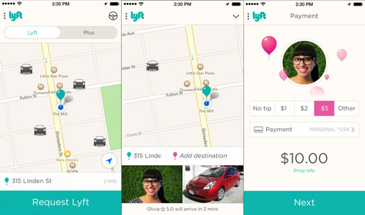
Screenshots from the Lyft app. / images: Lyft
Officials from the taxi-app company Lyft were in Albany recently to meet with city officials.
Matthew Peter, chief of staff for Albany mayor Kathy Sheehan, told us this week that representatives from Lyft had been in for a meeting "about two weeks ago." Peter described the meeting as a "very generic introduction" and said Lyft was currently in the process of introducing itself to cities. He said the Sheehan administration is looking into the topic and doesn't have a position on it.
"We're talking to cities across the state to see if there's a need for increasing safe and affordable transportation options," Lyft spokesperson Chelsea Wilson said to AOA this week when we asked about the meeting. "And we've heard that people want options like Lyft."
Lyft -- and competitors such as Uber -- have become key players in the taxi ride market in many cities around the country, all while pushing against what the companies say is outdated regulation and critics charge they're using unfair advantages.
Short commute, small footprint
Among the benefits to living near the Capital Region's urban core: on average, your household probably will have a lower greenhouse gas footprint.
The above map caught our eye while we were flipping through the docs for that Capital District Transportation Committee draft plan for the area's transportation future. It depicts the estimated average greenhouse gas footprint -- for both transportation and household use -- for households in each municipality. (After the jump, we've also clipped the map that depicts estimated greenhouse gas footprints just for transportation.)
The map is probably what you'd expect -- if a municipality, like the city of Albany, hosts a lot of jobs then its residents are more likely to not have to commute far, and as a result, won't have as large a greenhouse gas footprint. (And you'd probably expect the inverse, too.) In fact, that map matches up pretty well with maps for both daytime population swing and average commute time in the region.
We were curious about the estimates behind the map, so we dug out a Capital District Regional Planning
Commission report about a regional greenhouse gas inventory. The estimates are explained on p. 19. And the report also includes more, and larger, maps on the topic.
One highlight from those additional maps: An estimate of energy costs by municipality (p. 23). The difference between the low and high end is about $8,500 per year.
Four trends shaping the way people will get around the Capital Region in the future
Google's prototype self-driving car. / photo: Google
Sometimes it's a good idea to take a step back and ask, "Where are we going?"
That's exactly what the Capital District Transportation Committee is doing right now for the Capital Region with its draft New Visions 2040 plan. It's trying to map out where we're all going (figuratively) and how we're all (literally) going to get there.
So, what does this sort of plan include? Roads, bridges, traffic congestion, CDTA, bike lanes, car sharing, road diets, all that stuff -- and things that are even farther out (both in the future and, like, whoa), such as self-driving cars.
CDTC has a bunch of public meetings coming up at which it's hoping people will speak up about their concerns and hopes for transportation in the future Capital Region. (Details are after the jump.)
So we thought it'd be interesting to talk with CDTC executive director Mike Franchini this week about four trends he thinks will influence how we'll get around in the future.
CDTA Navigator
CDTA shared a few more details today about the fare payment system that's in the works. The transit org will be pilot testing the system this year, and could start rolling it out by the end of 2015.
A few bits about the upcoming "Navigator" smart cards:
Not in the driver's seat
An increasingly uncommon spot?
A theme that's popped up often in recent years among developers, planners, cultural observers, whoever: more people -- younger adults (the Millenials), especially -- don't like to drive. You see it mentioned in national articles, and we've had developers and planners mention it to us locally.
We had that idea in mind this week when we came across some numbers about vehicle use over the last few decades, both nationally and here in New York State. One thing led to another and we ended up calculating driver's licenses per capita for counties around the state. (Because of course.)
A few interesting bits floated by along the way. Among them: Of New York State counties that are not part of New York City, Albany County has one of the lowest levels of driver's licenses per capita in the state -- and the rates for all of the Capital Region core counties in 2013 were down compared to 2007.
Here are a few quick graphs, and a few thoughts.
Albany red light camera intersection map
There's a larger clickable map after the jump.
The Albany Police Department released the final list of intersections for the city's new red light camera system Friday. There are 20 intersections in all.
Here's the list with some crash stats, along with a clickable map, and a few quick things and thoughts.
The Capital Region's vehicle arteries
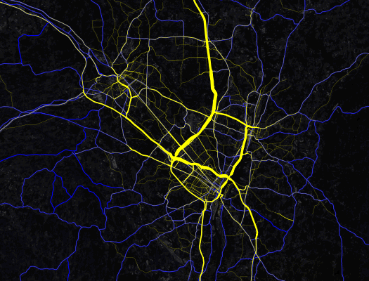
Map gawking: Check out this map of traffic volumes on major roads around the Capital Region. It's like an angiogram of the area's vehicle arteries.
The map is a clip from a national map created by Mapbox using data from the federal Highway Performance Monitoring System and OpenStreetMap. Here's a zoomable version over at the Mapbox site.
The data is limited to roadways, marked in yellow, that are eligible for federal aid. The wider the yellow line, the higher the daily average volume.
The relative volumes probably won't be much of a surprise -- you know, it's not unexpected that I-90 through Albany and I-87 from Albany north to Saratoga County are the most-traveled arteries (each averages more than 100,000 vehicles per day).
But one thing that did strike us about the map is the way it highlights the degree to which the Capital Region sprawls northward much more than any other direction. We've always been a little curious why areas such as, say, southern Rensselaer County and southern Albany County haven't been built up like southern Saratoga County.
[via @omarjpeters]
Earlier on AOA: The busiest Thruway exits
South End Bikeway Link
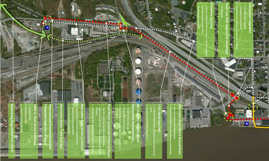
Here's an interesting idea: The South End Bikeway Link -- a proposal to connect Albany County Helderberg-Hudson Rail Trail with the Mohawk-Hudson Bike-Hike Trail and Albany waterfront.
A coalition of local bike, rail trail, and neighborhood group is supporting the idea. And there's a public meeting this evening (Wednesday) at the Albany Public Library main branch at 6 pm to share info and rally support.
Press release blurbage:
The proposed bike link would extend the existing Mohawk-Hudson Bike-Hike Trail further south and tie into the new Albany County Helderberg-Hudson Rail Trail. This much-anticipated "Rails to Trails" route will stretch 9.3 scenic miles to the Village of Voorheesville from the South End. The link will be wildly popular with bicyclists, runners, and walkers when the final Bethlehem-South Albany segment opens in late October 2015.
The busiest Thruway exits
Very busy.
Holiday travel around Thanksgiving got us curious about the busiest Thruway exits.
So we looked it up.
And it turns out one of the exits here in the Capital Region is the busiest toll exit on the Thruway. Exit 24 -- at I-90 and I-87 -- averaged more than 26 million Thruway vehicle entrances and exits between 2008 and 2013. In fact, it was wayyyy ahead of the #2 exit.
Are there rankings? Is there a clickable map? As if you have to ask...
Surveying Albany taxi experiences
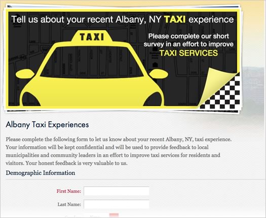
A screengrab from the survey.
Updated at 2:24 pm
The Albany Convention and Visitors Bureau is aiming to start a conversation about tax service in the Albany area via a new online survey collection taxi customer experiences.
As Schuyler Bull, the Albany CVB's director of marketing, said to us: "It's a large conversation to be had."
CDTA now offering realtime bus info
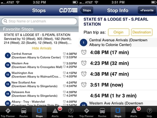
From the iRide app.
CDTA officially announced today that it's now offering realtime info for regular route bus arrivals.* The functionality has previously only been available on BusPlus. Blurbage:
Customers will be able to access real time transit information for CDTA fixed route services through the free CDTA iride mobile application for Apple and Android devices, through Google Maps' mobile apps and maps.google.com, through the trip planner on its website (www.cdta.org) or by speaking with a customer service representative at CDTA's Call Center. Customers will now see a gray clock icon near a route that indicates real time information is available. Real time is currently not available on Northway Xpress service. ...
CDTA tracks its vehicles using GPS devices to report bus location data back to its servers. This information allows CDTA to estimate when the buses will arrive at a stop. If a bus goes off its regular route, the system may not be able to fully predict accurate arrival times.
Here are screenshots of the realtime info display on both Google Maps and the CDTA website.
As long as the realtime info is accurate, the function is a nice addition. In our experience, some CDTA routes and stops tend to have reliable arrival times -- and others less so. (Yep, we're looking at you #10. We know it's not totally your fault what with all the traffic lights and riders. But you've interpreted the concept of a "schedule" very loosely.)
By the way: If you ride the bus, even just occasionally, and you have a smartphone -- definitely get the iRide app if you don't have it already.
* This function has been at least partially active for at least a few days. Thanks to the person who pointed this out to us last week.
CDTA was a sponsor of the Rail, River, Hudson tour.
Where to rent a passenger van?
 Eva emails:
I'm looking to rent a 7+ passenger van for 24 hours. Everything I'm looking at is too fancy - it just needs to be functional for short-distance transportation, not the newest Dodge SUV. Ideally I would like this to be a recurring rental (once or twice a month), so I'm hoping to find someone reliable. Any leads?
We're curious if there are options beyond the typical rental companies.
Got a suggestion for Eva? Please share!
Thinking about red light cameras
Talk to a lot of people in Albany about red light running and you'll probably get many stories about drivers blatantly blowing through lights. It is, anecdotally at least, a pervasive and persistent problem.
In an attempt to address the issue, the city of Albany is considering an ordinance that would allow it to place red light cameras at 20 intersections around the city. It's an interesting topic because the situation surrounding red light cameras ends up being a bit more complicated that you might at first think -- and because of the way the issue is pushing a lot of buttons for people. Opinions seem to span a range of something like "yes, the city needs this" to "no, this is a very bad idea."
Here's a walk through of the issue...
A bit more about protected bike lanes in Albany
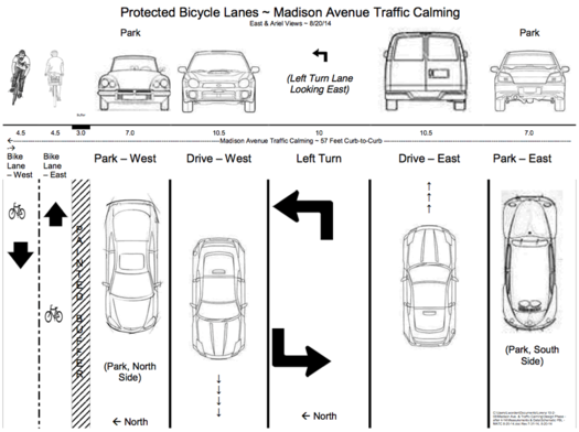
A few bits of follow up on last week's post about the Capital Region bikeshare:
Protected bike lanes
We mentioned that one of the ideas to make parts of the Capital Region more bike friendly are protected bike lanes -- generally speaking, these are bike lanes that are separated from car traffic by some sort of barrier. These sorts of lanes are said to be safer for cyclists, and they may help more casual cyclists feel better about using a bike for transportation.
As it happens, there's a group organizing to support the creation of protected bike lanes in Albany, specifically as part of the redesigned Madison Ave (the "road diet"). The group's FB page is posting information about protected bike lanes and other bike-friendly ideas.
Also, a proposed Madison Ave redesign that incorporates protected lanes floated our way. The design is above -- here's a large-format version. It was created by Lorenz Worden of the Albany Bicycle Coalition. And it provides an easy-to-understand layout of how redesigned Madison Ave could maybe work.
We gotta admit we're not totally sold yet that protected lanes will prompt a significant number of people to start cycling more often. But the idea looks promising and it's worth a shot. Madison Ave seems like as good a place as any to try it.
Bikeshare recap
Over at the TU, Tim O'Brien has some numbers from the Capital Region bikeshare now that the pilot has ended: there were more than 250 participants, who averaged 2.8 rides during the trial period.
Taking the Capital Region Bikeshare for a spin
The Capital Region Bikeshare pilot is finishing up this week in Albany after week-long stints in Schenectady, Troy, and Saratoga Springs. The test run finishes up this Saturday, August 16.
We were curious about the program, so on Thursday we registered and took one of the bikes for a spin. Here are a few thoughts about the program, and about cycling in Albany generally...
Info sessions on new CDTA smart cards and mobile payments
 Pay by mobile phone to ride the bus?
CDTA isn't there, yet -- but it hopes to be by next year. This week the transit org is starting a series of public outreach sessions to discuss its plans for new smart card and mobile ticket options. The fare payment options are made possible by the new fare boxes that have been popping up on buses.
The transit org says the proposed new system won't affect base fares -- they're focused on prepayment options.
The first meeting is this Wednesday in Clifton Park. There will be five other meetings during August at various spots around the Capital Region. Schedule is at that first link.
CDTA was a sponsor of the Rail, River, Hudson trip.
How you get there matters, because getting there is half the fun
Part of the Albany riverfront was once known as Steamboat Square (shown here in 1921), where people would board steamships for travel along the Hudson River. / photo from Library of Congress via Wikipedia
By now, you probably know "The New York City People" have arrived in Hudson. Or as one writer for the BBC put it, the place has become "a far north weekend colony of New York City."
Like most Upstaters, I'm not impressed by people simply because they're from "New York." But I am impressed by how they come from New York to Hudson. They take the train, for two hours.
Not only does that demonstrate the appeal of Hudson, it demonstrates the appeal of traveling by train. Or any car-free and easy travel, really. The key word being easy.

Park South redevelopment plan gets final OK
A rendering of the mixed use buildings along New Scotland Ave.
Updated with newer renderings
The plan to clear and redevelop two whole blocks in Albany's Park South neighborhood got approval to move ahead from the city planning board Thursday evening. Phased demolition of the existing buildings will be starting soon, and construction is slated to begin this October.
The $110 million project -- a collaboration between Albany Medical Center and Tri-City Rentals -- includes more than 265 residential units, retail space along New Scotland Ave, a large medical office building, and a parking garage. Much of the plan has been met with enthusiasm and support by city leaders and community members, but the garage -- and its size -- has been a frequent target of criticism. And Thursday evening was no different.
Capital CarShare launching soon
The Capital Region is just a few weeks away from the start of its first independent car sharing operation.
Capital Car Share is aiming to start around the end of June, marketing and outreach coordinator Nnenna Ferguson told us today. The org will begin with 8 vehicles available for per-hour use, distributed at 8 "parking hubs" around the city of Albany.
How the Albany metro area ranks for pedestrian deaths -- and ways it could be safer
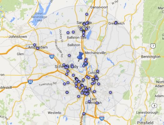
A clip from an interactive map posted as part of the report. You can pick a point and the map will report nearby pedestrian deaths over a given time period.
There were 88 pedestrian deaths in the Albany metro area between 2003-2012, according to a recent report from the org Smart Growth America. The Albany metro area's rate of pedestrian deaths per 100,000 people was 1.06, which ranked in the lower middle of metro areas in New York State.
A handful of bits from the report -- which details some of factors in pedestrian deaths, and calls for changes in how roads are designed -- are after the jump.
How people get to work in the Capital Region
The way to get to work? Not for many, but it is for some people.
This Friday, May 16 is Bike to Work Day, which seemed like a good excuse to take a look at how people get to work in the Capital Region. And, thanks to the Census Bureau, there are some numbers that can give us some sense of that.
So, let's have a look -- at how people get to work, how long it takes them, and when they leave...
A miniature version of Troy and its past
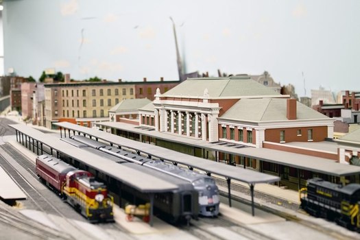
Troy's former Union Station as it once was -- and still is, in miniature.
Of all the things you might expect to find in the basement of a college dorm, a meticulously-built recreation of 1950s Troy is probably not one of them.
Yet in the basement of RPI's Davison Hall the Rensselaer Model Railroad Society has been constructing a to-scale version of the city and other spots around the region that were connected by rail. The work has been going on for more than three decades -- and it's a sight to see.
CDTA sets annual ridership record
 Transportation fact of the day: CDTA recorded 16.49 million boardings during its last fiscal year* -- a new annual record, according to the transit org. The previous all-time record was from FY 1983.
CDTA's on a remarkable upswing in ridership over the last few years. It's seen increases each of the last three years. And the just-ended fiscal year is up more than 2.5 million boardings compared to 2010-2011 -- an increase of almost 20 percent. (ridership totals via CDTA Historical Performance Data)
A question we're curious about, though it probably can't be answered with great accuracy via the data: How many individual people rode the bus during that year? It'd be interesting to see if the bus is appealing to more people, or the people who are already riding it are riding it more often.
As we've said before, riding the bus can be a good experience, and not just because you don't have a car or some other sort of transportation option. In some cases it can be a superior experience to driving because you don't have to deal with parking, the stress of traffic, and you can just zone out or read along the way. The CDTA system isn't without flaws -- anyone who rides the bus regularly will have their frustrations, we know we do. But we suspect there's a not-insignificant chunk of people who might enjoy/prefer riding the bus regularly -- they just don't know, yet.
* CDTA's fiscal year runs from April-March.
Push for car sharing in Albany revs again
![]() The campaign to start a car sharing org in the Capital Region has surfaced again and is looking for support.
The campaign to start a car sharing org in the Capital Region has surfaced again and is looking for support.
Capital CarShare is aiming to raise $20,000 by the first week of June via crowdfunding. The drive is a "flexible funding" campaign on IndieGogo, meaning the the org will get whatever money is pledged, whether it makes the goal or not.
Campaign blurbage:
Capital CarShare (CCS) was developed by a small group of passionate, environmentally-conscious, upstate New Yorkers looking to bring shared mobility to the dense region of Albany. With CarShare, community members will have easy access to a vehicle for use by the hour or by the day. Our goal is to launch a fleet of neighborhood cars by June, but we need your help to #getthere.
We need to raise $20,000 to help us purchase a fleet of eco-friendly vehicles, fund our first advertising campaign, and hire staff members.
The push for car sharing in Albany goes back years. Advocates have pitched it as a way to provide flexible, affordable transportation while addressing parking and environmental issues.
But the plan hasn't made it all the way to implementation here, so far. And apparently that's not uncommon for smaller cities -- though a few, such as Buffalo, have made it work.
A good driving instructor?
Baby Boomer emails:
Could you ask your readers if they could recommend a driving instructor, specifically in Albany, who could teach an older person who is very nervous when learning to drive? I took a few lessons years ago and was very stressed out. I still want to learn before I get too old.
A bunch of years ago we had a question about driving schools, but it was in reference to teens. Things change. And also, we're curious if there are any driving instructors who specialize in -- or just happen to be really good with -- adults who are taking up driving.
Got a suggestion for Baby Boomer? Please share!
Startup Grant Contest update: The Giddy Up Bus

Traci Cornwell's successful Giddy Up Bus was a finalist in the AOA Startup Grant Contest in 2012. (photo: AWASOS Entertainment)
There are just over two weeks left to enter a business idea in the All Over Albany Startup Grant Contest, sponsored by Staff Ciampino & Company P.C., Certified Public Accountants. One winner will receive $1,500 from Berkshire Bank to help start up a new business, or take an existing business to the next level. You should apply. Don't wait!
One of the things we love about the Startup Grant Contest is that not only does it help the winner, it also calls attention to lots of interesting, creative ventures in the Capital Region. Past finalists have gone on to build successful ventures based on the plans they proposed, with a bit of help from the feedback provided by the startup contest judges.
One of those finalists is Traci Cornwell, the entrepreneur behind the Giddy Up Bus, a bus service that runs from Albany to Saratoga and transports people for weddings and special events.
Traci was just 23 years old when she entered the contest and was selected as a finalist. Though she didn't win, she says the feedback from the judges was invaluable. Today she's successfully operating the Giddy Up bus and is considering adding a second bus to the fleet in the fall.

Scheduled for arrival at ALB: JetBlue
 Announced today: JetBlue will begin service out of Albany International Airport in 2015. Chuck Schumer has been pushing for the airline to serve ALB, so he was chuffed about the announcement. Said the peripatetic Senator in a press release from his office:
"This should increase competition at the airport, increase the availability of flights to Albany International's most popular destinations, like Florida, and drive down prices for the average flyer. What's more, it will keep more residents in the area flying out of Albany, instead of traveling out-of-state for cheaper flights. It's a win across the board that will reap benefits for Albany International, JetBlue, and the region's tourism industry for years to come."
The two flights planned for the ALB schedule: Fort Lauderdale and Orlando. Here's JetBlue's current service map. Its slate of upstate-ish cities currently includes Buffalo, Rochester, Syracuse, Newburgh, Westchester, and Burlington.
When word started spreading about JetBlue's impending arrival this morning, we noticed a bunch of people in our Twitter stream hailing the news. To which we ask, earnestly: Why?
We're kind of the thinking that most airline travel is pretty much like any other airline travel these days. Sure, there's some variation -- the Southwest people might be a bit funnier and that airline doesn't charge you for checking a bag. But on price, and many other aspects, there doesn't seem to be a lot of difference. So, aside from the increase in competition, what's the big deal? If you've flown JetBlue, please share. We're genuinely curious about what separates this airline from the others.
Elsewhere: A ranking of nine major carriers by the WSJ released in January pegged JetBlue at #5.
photo: Aaron Gustafson (cc) via Wikipedia
Thinking about high-speed rail in New York
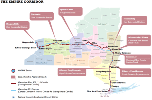
A map detailing some of the options on the table. (Don't squint, here's a bigger version.)
High speed rail in this country is one of those things that always seems to be happening just over the horizon. And for the Northeast -- and the Capital Region specifically -- this somewhere-out-there future holds all sorts of potential. Imagine what it would be like to hop a train at Albany-Rensselaer -- the 9th busiest station in the nation -- and be in NYC in a little more than an hour.
The thing is, for all the talk, we never seem to get closer to actually arriving at high speed rail. But that might be changing. Slowly.
The state Department of Transportation is currently working to sort out plans for higher speed rail service through New York. And there was a public information session Tuesday at the NanoCollege about the options, the first of series of sessions around the state.
We stopped by, checked out the presentations, and talked with one of the people involved in the planning. Here's a breakdown of the state's current route toward high-speed rail.
An attempt to hail Uber for the Albany area
Screenshots from the Uber mobile app.
Whenever the subject of Capital Region taxi services comes up, there are almost inevitably a number of complaints. The dissatisfaction seems to stem from people being a) unhappy with the reliability of service or b) unclear about the vague pricing system or c) both "a" and "b."
But maybe there's a why shake things up for the better. Two of the area's prominent entrepreneurs -- Matt Baumgartner and Vic Christopher -- have started a campaign to attract the service Uber to the Albany metro area. Uber and its fleets of drivers allow riders to order, track, pay, and rate car service by mobile app.
Christopher, the owner of The Confectionery and The Grocery in Troy, told us today that he was "blown away by the genius of this concept" after he and his wife, Heather, had recently tried Uber while traveling through cities out west, including Denver, LA, San Diego, and San Francisco.
"We discovered it while out in Denver, at Ace, a ping-pong noodle bar," Christopher said via email. "It was recommended by our bartender. We downloaded the app, signed up, and hailed our first cab within 3 minutes. ... We used this service many times during our trip, and found the drivers to be professional and personable, 100% of the time. The drivers I met were all thrilled with the program, as they are now working for themselves, opposed to a taxi company. They seem to all share a sense of pride in being their own boss."
Back here in the Capital Region, Christopher said he ran into Baumgartner and found out they shared an appreciation for the service. Explained Baumgartner: "Vic and I started this conversation because I was in Troy and called a cab company to pick me up because there were no cabs available on the street. I waited for 25 minutes, and when the cab showed up, there were 3 people in the back seat. There needs to be a better option than that."
So they decided to reach out to the company together, and start a social media campaign to raise awareness and rally support.
The Atlantic: The future of urban highways is playing out in upstate New York
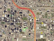 Over at The Atlantic Cities today there's a good overview of the situation surrounding the impending replacement of I-81 in Syracuse, which runs right through the heart of the Salt City's downtown. The situation will probably sound very familiar to anyone who's thought about the future of I-787 in Albany. A clip:
City leaders like Robinson, along with downtown developers and advocates for smart growth, would like to see I-81 rerouted around Syracuse and replaced with a landscaped boulevard. But suburban business-owners and many of the 45,000 drivers who use the highway to commute fear that any change could hurt the local economy. It's a debate that goes beyond the immediate question of how Syracuse workers will get to work -- to what kind of city Syracuse will be in the 21st century.
Similar discussions are happening across the United States, says John Norquist, president of the Chicago-based Congress for the New Urbanism, which publishes an occasional list of interstates ripe for demolition. Many urban freeways -- a staple of mid-20th century car-centric development -- are beginning to fall apart, and today cities from New Haven to Seattle (not to mention others around the world) are taking the dramatic step of tearing them down. A former Milwaukee mayor, Norquist oversaw the conversion of an elevated highway to a boulevard there in 2002, following a model pioneered by Portland in 1978 and San Francisco in 1991.
"It's starting to happen all over the place, and there's a reason for it," says Norquist. "Freeways don't add value to cities. They're all about one dimension, which is just moving traffic. It's a rural form, visited upon the city, that destroys property values, commerce and vitality."
The article, by Amy Crawford, is a good overview because it captures many of the tensions of the situation -- between city and suburbs, between walkable and automobile infrastructure, between local and state decision making. And, oh yeah, cost.
As that clip mention, the thing about these elevated highways, 787 included, is that they eventually will reach the end of their lives -- because they will be literally falling apart. That will mean hard choices -- and maybe also big opportunities.
[via @rachbarnhart]
Earlier:
+ In another upstate city, a discussion about an urban highway
+ "The Life and Death of Urban Highways"
+ The Albany 2030 plan included a goal of evaluating possible alternative designs for 787
+ The Stakeholders org released a report in 2011 that imagines the Albany waterfront with a boulevard
map: I-81 Challenge
An updated mobile app for riding CDTA
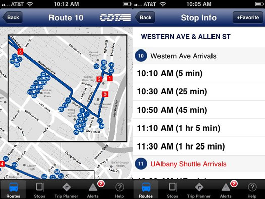
Screenshots from route map and stop info screens.
There's a new CDTA "iRide" mobile app out this week. And after playing around with it for a day or so, we like it better than the old one.
CDTA blurbage on what the new app includes:
The new iRide application offers intuitive searches by route, specific bus stops or Capital Region landmarks. Schedule maps have been updated and turn by turn directions are now included. The iRide app is GPS-enabled and offers the nearest stops by proximity to the actual location.
The new version is currently available for iOS. CDTA says an Android version is scheduled for March.
In our experience the functions we need most from a bus system app are pretty simple: what's the route map, and when's the next bus arriving? And the new app so far feels like an upgrade -- both functions are easy to find and use. The "stop info" screens -- offering the next scheduled arrival times for a stop -- are straightforward and simple (a good thing).
One thing we'd still like to see improved: Better indications about which stops are for which directions on a route. Listing two stops by the same name -- because they're right across the street from each other -- is something less than helpful because you have to figure out which side of the street, and thus which direction, is which. Maybe it's something for the next version.
As we've said before, we suspect there are a fair of number of people who might actually like riding the bus -- they just don't know it, yet. And that's understandable. If you don't ride the bus regularly, switching over is a change in routine and takes a bit of effort. We've found that using a mobile app helps in this regard. So if you've been thinking about giving the bus a shot, the app is a good place to start.
By the way: CDTA says this app is part of its longer term plan to eventually allow riders to pay fares with smartcards or smartphones.
Why Albany is playing a major role in the transportation of oil, and why that concerns some people
The Port of Albany.
There's been a lot attention recently on the Port of Albany's growing role in the shipment of crude of oil -- and the potential dangers involved. More specifically, a company has proposed building a new facility at the port that could potentially open the way for a different type of oil to be shipped through the port, and that's raised some questions.
If you haven't been following this issue -- and we don't really know why you're not thoroughly caught up on petroleum product distribution systems -- here's a Q&A-style breakdown of some of the issues involved -- and why people are concerned.
A few more bits about the proposed BusPlus Washington-Western line
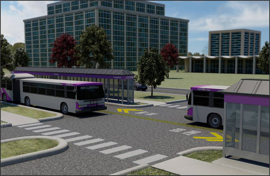
On Wednesday CDTA announced that its board had voted to take another step toward the proposed expansion of the BusPlus bus rapid transit system to the Western-Washington corridor -- AKA, The Purple Line. This bit from the announcement caught our eye (emphasis added):
The [official designation of the preference for this plan] includes construction of a dedicated busway through the Harriman Office Campus and the University at Albany, a transit center at Crossgates Mall, and high-volume stop locations.
The "dedicated busway" was news to us -- and we were curious about what it meant. CDTA's Jonathan Scherzer explained:
We are working with both the University and [state Office of General Services] on the inclusion of a dedicated roadway that would be used exclusively for transit, maintenance and shuttle vehicles. The current design would face the soon to be completed Campus Center on the UAlbany campus while also providing good proximity to the new football stadium to ease traffic.
That rendering above projects what the lane might look like on the office campus (it appears to be the Western Ave side of the campus, near the campus access road).
As we've said before, bus rapid transit is probably the closest this region will come to any sort of light rail-type system in the not-way-distant future. Building this sort of infrastructure -- the busway, the transit center -- looks like a good step toward making BusPlus a real system, something more than just an express bus, which could be key to its longterm success. Because there's a line of thought that making BRT more than "just the bus" is key to it gaining a broader crowd of users.
See also: CDTA chief renews call for downtown Albany transit hub [Biz Review]
After the jump: A bonus rendering of the proposed transit center at Crossgates, and a pdf info sheet about the proposed Purple Line.
Two new options for Park South
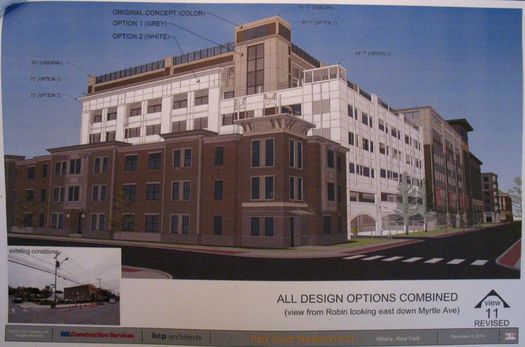
A visual comparison of the two new options against the previous option. (Don't squint, here's a bigger version.)
The evolution of the plan for the $110 million redevelopment of two whole blocks in Albany's Park South Neighborhood -- and the big parking garage that's prompted so much conversation -- continued Friday with two new options presented to the Common Council committee examining the plan.
New renderings, comments, and a few thoughts post jump...
STOP. WRONG WAY.
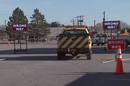
From a Thruway demo video.
From the Annals of Highway Signage Technology: The Thruway Authority has developed electronic "wrong way" detectors/signs and will be installing them in places where wrong way drivers have caused crashes in the past. The first spots to get the systems: an exit on the Niagara Expressway (I-190) in Buffalo and exit on I-87/I-287 in Rockland County.
So how does an electronic sign "know" that someone is driving the wrong way? Cuomo admin press release blurbage:
These new signs are the latest development in the Thruway Authority's work to ensure that motorists have the highest level of safety while on the 570-mile superhighway. Doppler radar is used to detect vehicles traveling the wrong way and when identified, the sign flashes a customized LED message to alert the drivers of their error and instruct them to pull over and turn around when it is safe to do so. The sign will also trigger automatic alerts to other drivers on the Thruway's variable message sign system, and automatically alert the Thruway's Statewide Operations Center.
Doppler radar? Like the First Alert Storm Tracker Extreme Hype Doppler 10,000 Radar used by TV weather people?
Well, sort of. Doppler radar makes use of the Doppler effect (surprise) to figure out which way things are headed and how fast. (Skipping over the part about an Austrian guy and physics.) You totally know the Doppler effect. It's the reason a fire truck siren or train whistle sounds higher as it approaches, then lower as it moves away. Doppler radar makes use of that change in frequency (using microwaves, instead of sound) to figure out direction and speed.
The Cuomo admin says the sign system was developed by a Thruway engineer, Steve Velicky, and made by a pair of upstate companies. The Thruway's exec director said in a release today that the system will eventually be expanded to other sites around the state.
What is a reasonable price for a cab ride from ALB to downtown Albany?
 Carolyn emails with a holiday travel question:
Wondering if you can do a thread on what to expect if you're flying into Albany and trying to get to downtown Albany by taxi. In the past I have had to some strange experiences. I.E. having to share cabs with strangers and then been price gouged for the pleasure.
This year I'm going to try and set a price before leaving the airport but I'm not even sure what's normal here. What is a reasonable amount to pay for a cab from the airport to Albany? Thanks and happy holidays!
Let's just put this way: We don't think Carolyn is alone in having odd Capital Region experiences. We're guessing plenty of people have their own similar stories.
So, got an answer to Carolyn's question -- or even just some local taxi negotiation strategies? Please share!
photo: Flickr user Ben Fredericson (xjrlokix) (cc)
Trolley history lunch at the U Club
 Could be interesting: Albany city historian Tony Opalka will be at the University Club December 18 for a talk titled "Transit in the City of Albany: 1862-1946." The talk is part of a noon luncheon that day, tickets are $20 and open to the public (reservations are required).
Yep, a midday event on a Wednesday can be hard to make, but it caught our eye -- because trolleys. Blurbage:
Tony is well known for his popular and informative walking tours of Albany's historic neighborhoods. Currently, he is employed as a historic preservation program analyst for the New York State Office of Parks, Recreation, and Historic Preservation. His presentation will feature slides with historic images of transit in Albany, as well as trolley and transit artifacts.
If you wish to start your holiday celebrating a bit early, try an Albany Street Car - the U. Club's spin on the classic Sidecar cocktail. It's made with Quackenbush Still House Original Albany Rum (from the Albany Distilling Company), Cointreau and sour mix - and guaranteed to ring your bell!
There Capital Region once had a robust system of inter and intra-city trolleys. (That image on the right is an old map of the trolley system around 1911.) So rich is the history is that it's almost like something from an alternate timeline.
The U Club luncheon is from noon-1 pm on December 18. Lunch starts at noon, talk starts at 12:30.
map from Trolley Trips Through New England 1915, via Fordham University Libraries Digital Collections
Expanding BusPlus on two lines
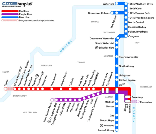
CDTA released proposed maps for its planned expansion of the BusPlus bus rapid transit system. There's a map above (and a larger version).
The current BusPlus line runs along Route 5 between Albany and Schenectady (Central Ave in Albany and Colonie/State Street in Schenectady). The two proposed lines would run along two corridors:
+ Washington Ave/Western Ave in Albany and Guilderland, serving stops such as UAlbany (both downtown and uptown), Saint Rose, the Harriman state office campus, and Crossgates.
+ The "River Corridor," running from the Port of Albany north through Menands, Watervliet, over to Troy, and eventually in Cohoes and Waterford.
CDTA says Washington/Western (3.4 million annual boardings) and Albany/Menands/Troy (2 million annual boardins) are its 2nd and 3rd most-traveled corridors. The Route 5 corridor tops that chart.
The routes for the new lines are still in the proposal stage. There will be a public "open house" to get public feedback on the Washington/Western line on November 12 at UAlbany's downtown campus (5-7 pm, Milne Hall).
And, of course, there's the matter of money. The first BusPlus took about $25 million in funding to get going. CDTA is hoping to score federal money for the new expansion -- Chuck Schumer was in town to pledge help with that.
Two things about train travel
The trains will keep running
The state Department of Transportation announced today that it's worked out a new cost-sharing agreement with Amtrak for passenger rail service in the state. So what? Well, now the trains won't stop running later this month, as was possible if DOT and Amtrak couldn't work out a deal. (A major public institution stopping service because two sides couldn't work a deal, who ever heard of such a thing? Oh, wait...) [NYS DOT] [TU]
DOT says it costs Amtrak $100 million a year to operate the Empire, Adirondack, Maple Leaf, and Ethan Allen lines -- and the state will be picking up $22 million of that. The Empire Service -- between Albany and NYC -- is among the most-traveled Amtrak routes in the nation, but it's revenues didn't cover its expenses as recently as 2011.
And there they go
Also this week: Amtrak unveiled a new interactive train locator map, in partnership with Google. Blurbage:
The new train location tracking system, available at Amtrak.com, provides near real-time train status of more than 300 daily trains, estimates of arrival times and station information - all in the context of the Amtrak national system map. Checking on train status is the second most popular action on Amtrak.com, just after purchasing tickets.
In addition to helping passengers plan travel, this new travel resource is an excellent tool for those planning the arrival or departure of family and friends. Users can search for information by train number or name, city name and station name or code.
That's a screengrab above of the Empire Service from this afternoon.
The modern world: rest stops are "text stops"
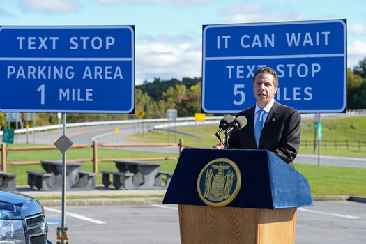
The Cuomo administration announced today it has designated 91 "texting zones" along the Thruway and state highways. The zones are already-existing rest stops, parking areas, and park-and-ride lots. (Example: The New Baltimore Thruway service area near Albany.) They're designated by 296 new signs indicating their distance (above).
So, if ever you wondered, "I just got coffee at this Thruway service area, might I also text someone while parked here?" -- you now have definitive signage indicating an answer: Yes, yes you can. Your travels will no doubt be smoother without this question burdening you.
The "texting zone" designations are part of the Cuomo admin's ongoing campaign against distracted driving. In announcing the signs today, Andrew Cuomo also shared some numbers from the state's stepped-up enforcement of mobile talking/texting while driving:
For the period July 4-September
2013 tickets issued: 21,580 (16,027 talking / 5,553 texting)
2012 tickets issued: 5,208 (4,284 talking / 924 texting)
New York State has strengthened its laws against phoning/texting while driving over the last few years -- it's now a primary offense (meaning you can be pulled over for it specifically), and a ticket is now worth 5 points. Also the Cuomo admin says State Police have been using unmarked SUVs to peer into vehicles to see if people are texting while driving.
Distracted driving is an important issue. There's research that indicates using a phone while driving is like having a .08 blood alcohol level, the legal limit. Also: it irks everyone else when you don't start moving at the green light because you're looking down to text.
photo: Cuomo administration
Amtrak: all-time record ridership in July
Amtrak announced this week that it set a one-month ridership record in July with 2.9 million passenger boardings, the most ever in the system's history.
Ridership on the Empire Service -- which runs between Albany/Rensselaer and NY Penn was 99,801 in July, up more than 7 percent during the same month last year. That made the Empire Service the 5th most-traveled short distance corridor in the nation during July. (And it ranks the line 7th for the whole system when you include the Northeast Corridor and Acela.)
Fiscal-year-to-date ridership on the Empire Service through July was 894,616 -- up 1.2 percent compared the same period the year before. That also ranked #5 for most-traveled short distance corridor.
After the jump, ridership numbers by line for July and year to date, sorted by ridership levels.
The bill that authorizes federal funding for Amtrak is up this fall -- and there's expected to be a fight over it in Congress. [The Hill via @RachelBarnhart]
Transportation options for a group day trip?
 Jeff, from the American Outlaws Albany Chapter -- the fan group for the US Men's National Soccer Team -- emails:
July 16th the US Men's Soccer Team has a Gold Cup game at Rentschler Field in Hartford. We have plenty of members (Albany AO chapter) planning to go and many have said they're bringing friends. Originally we were just going to carpool but some beer and prodding led to me agreeing to research transit options.
Realistically we would leave around 2 to 3pm and return soon after the game which would end at 10pm.
Freedom to have some "fun" (music/noise and adult beverages) on board is a huge plus, but value is first concern. I have heard good things about a new company recently but can't find them - I believe they ran a bus from Olde English or Barrel Saloon to SPAC for a concert?
Jeff says they're looking at a group of 20-40 (or more).
Got a transportation suggestion for the group? Please share!
Which arrives first? The electric cars, or the places to charge them?
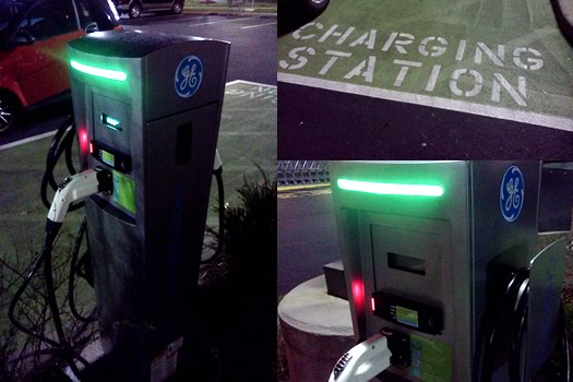
An EV charging station at the ShopRite in Niskayuna. (photo: Kristofer)
Gina recently contacted us looking to get some help with a situation, which breaks down like this: She and her husband are thinking about getting an electric car. He'd be using the car to commute -- he works at the Capitol. And though he's seen that the ESP has charging stations for electric vehicles, they're apparently not for general use.
As Gina commented in her email to us (link added):
"For all the hype and press releases from the Governor's office about a new network of chargers statewide, the actual process for using them *on state worker territory* is frustratingly opaque."
So we looked into the situation a bit. And we managed to get an answer. But more than anything, their situation highlights one of the challenges facing electric vehicles generally.
TWD, 5 points
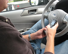 The state DMV is increasing the penalty for getting caught texting while driving, the Cuomo admin announced today. The penalty for TWD increases from three points on a license to five. And Andrew Cuomo has also directed the State Police to step up enforcement during the summer.
Cuomo is proposing a new law that would include a 60-day license suspension for new/young drivers caught for TWD, and temporary revocation if their caught again within 6 months of having their license restored.
New York has strengthened its law against using a mobile device while driver over the last few years. In 2011 the number of points on a license for texting while driving was increased from two to three, and TWD became a primary offense -- meaning a driver could be pulled over specifically for that. As a result, there's been an upswing in the number of people getting tagged for it.
Distracted driving often gets compared to driving while drunk. And there's research that indicates that using a phone while driving is like having a blood alcohol level of .08, the legal limit. The Cuomo admin shared some stats today in that vein:
+ From 2005 to 2011, there has been an approximately 143% increase in cell phone-related crashes in New York State. In that same time period, there has been an approximately 18% decrease in alcohol-related crashes in New York State.
+ In 2011, there were 25,165 fatal and personal injury crashes involving distracted driving in New York, compared to 4,628 caused by alcohol-related driving.
+ In New York State, the number of tickets issued for texting-while-driving (30,166) approached the number of DWI/DWAI arrests (43,954) in 2012. In fact, between 2011 and 2012, there was a 234% increase in the number of tickets issued for texting while driving. In the same time period, there was a 4% decrease in the number of DWI/DWAI arrests.
The NYT produced a good series about distracted driving a few years back.
Points
Right, so, points on a license... how's that work? Points are assessed by the DMV based on violations such as speeding (3-11 points, based on how far above the limit) or running a stop sign (3 points). Rack up 11 or more points in an 18-month period, and it's license suspension.
photo: Flickr user mrJasonWeaver (cc)
In another upstate city, a discussion about an urban highway

Syracuse's I-81 viaduct.
Related to the I-787 discussion that pops up now and then: There's an interesting situation in Syracuse regarding what to do with the the elevated portion of I-81 that cuts right through the middle of that city. The thoroughfare is falling apart, so something has to be done -- and the options have been narrowed down to either: turn the stretch into a six-lane boulevard through the city, or completely rebuild the elevated highway. [I-81 Challenge] [Syracuse Post-Standard]
Some of the numbers involved in the decision are eye-popping: both the boulevard and reconstruction of the 1.4 mile stretch could cost as much as $900 million, according to the Syracuse Post-Standard article linked above. Other options -- such as burying the road -- have been dismissed because they'd cost in the $1.5 billion range.
The situation in Syracuse has ended up polarizing along city/suburb poles, with the county legislature and developers opposing the boulevard because of concern it would make it harder for suburban commuters to get in and out of the city. In a recent op/ed, David Rubin -- a former dean at Syracuse University, which sits right along I-81 -- called the project "the most important civic decision of the past 60 years or more" and argued for the boulevard plan. [Syracuse Post-Standard] [Syracuse Post-Standard]
Case studies: The state Department of Transportation and the Syracuse Metropolitan Transportation Council have collaborated on an ongoing public discussion about the project called "The I-81 Challenge." It produced a report that includes a bunch of case studies of how other cities have dealt with the reconstruction or reconfiguration of urban freeways. If you're interested in the future of 787, the case studies are interesting reading.
Earlier:
+ "The Life and Death of Urban Highways"
+ The Albany 2030 plan included a goal of evaluating possible alternative designs for 787
+ The Stakeholders org released a report in 2011 that imagines the Albany waterfront with a boulevard
+ The removal of 787 in downtown Albany was on Martin's urban wish list
map: I-81 Challenge
CDTA: Ridership at highest level in three decades
There were almost 15.7 million passenger boardings on CDTA buses during the fiscal year that ended in March -- that's up 5 percent from the year before. And the transit org says it's the highest level in three decades.
CDTA attributes the rise to the introduction of the BusPlus service between Albany and Schenectady. Ridership is up 20 percent along that corridor since the bus rapid transit system started. Another program pushing ridership: deals with colleges and businesses to provide students/employees with unlimited bus ridership.
There's a lot to like about riding the bus, especially on shorter trips within cities. We like being able to hop on the bus and not worry about finding parking wherever we're going. And it's nice to just be able to zone out or read along the way. It can actually be kind of relaxing. Or to put it another way: the opportunity cost of driving is probably higher than most people realize -- especially when you have a smartphone -- and riding the bus is way to cash in on that.
Earlier on AOA:
+ A few things about riding the bus
+ The not-so-rapid rise of bus rapid transit
Token of history
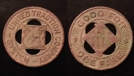
A quick follow up to last week's post about the history of trolleys in the Capital Region: Andrea mentioned to us that she once found an old trolley token outside her apartment in Albany. And she sent along pics. One for each side is above.
The United Traction Company operated the trolleys in Albany for almost five decades. UTC was formed in 1899 by the merger of the Albany Railway, the Troy City Railway, and the Watervliet Turnpike and Railway Company. Its headquarters were at the Columbia and Broadway in downtown Albany -- the building is still there. The company switched over to buses when the trolleys stopped, and was later folded into CDTA during the 1970s.
If you'd like to see what an untarnished token looked, the New-York Historical Society has a photo.
(Thanks, Andrea!)
Riding the trolley -- everywhere
Madison Ave in Albany sometime during the 1940s. Courtesy of The College of Saint Rose Archives.
There's something about trolleys that lights people up -- even though a lot of people weren't even alive the last time a trolley rolled through Albany. It's been almost 70 years since the lines stopped.
We were thinking about trolleys again this week after seeing this photo from the College of St. Rose Archives. It's Madison Ave at Partridge, facing west, sometime in the 1940s, right about the time the trolleys stopped. We love the way the tracks lead away covered by the canopy of trees.
That photo prompted us to dig through some of the history of trolleys in Albany -- which is like looking through some alternate transit universe.
Report: Amtrak is really two systems, one efficient -- the other, not so much
A new Brookings report on Amtrak makes an important distinction on passenger rail service: distance matters. From the report:
The 26 routes traveling less than 400 miles make up the operationally efficient portion of the network. It includes the two most popular Northeast Corridor routes, the Acela and Northeast Regional, which operate between Boston and Washington D.C., including spurs into Virginia and western Massachusetts. The positive operating balance from these two routes--which currently do not receive direct state operating subsidies--were enough to offset the net operating costs of the other 24 short- distance routes. Those other sub-400 mile routes typically enjoy direct state support (even before the federal PRIIA legislation) and always serve at least one large metropolitan area. In total, these 26 corridors carried 83 percent of all system riders in 2012.
In fact, when taken all together Amtrak routes of 400 miles or less actually had a positive operating balance in 2011. The over-400 mile routes were in the red.
That said, some of the short distance routes don't do too well financially. And the Empire Service -- which runs between Albany and NYC -- is one of them. That line -- which doesn't get state support (it will starting later this year) -- had a negative operating balance of $31 million in 2011, almost half the cost of the service. But the Empire Service was the 7th most popular line in terms of ridership in fiscal year 2012, at 1.06 million riders. [TU] [AOA]
The Brookings report also includes ridership numbers by metro area, not just by station. And it reports riders in Albany-Schenectady-Troy metro area to 862,737 in 2012 -- up 39 percent from 1997.
Amtrak had 31.2 million passengers in fiscal year 2012. The Brookings report notes the rail service is the fastest-growing domestic transportation mode over the last 15 years.
Earlier on AOA: An updated vision for high-speed rail
A pledge for pedestrians and drivers

This has been a bad week for pedestrians. One person was killed on Central Ave in Albany, another hit just up the street during a vigil for the first person. And in North Greenbush, a pedestrian was hit by truck with a snowplow attached. [TU] [Troy Record]
Unfortunately, a week like this isn't surprising. I walk a lot -- because I have a dog, because I prefer it to driving when possible, just because I like it. Rare is the week that I don't have a an encounter with a vehicle that's a little too close. A lot of times it's a result of something a driver did (or didn't do) -- roll through a right on red, not respect a crosswalk, or just not pay attention to what's going on. But I'm also sure there are times I could have been a better pedestrian.
So, pedestrians and drivers need to come to some sort of understanding. And toward that end, here's a pledge for pedestrians and drivers (and municipalities) to do better...
Driving the new Washington Ave/Fuller Road florcle
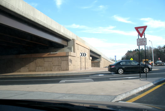
The new flyover/circle.
The new flyover/circle at Washington Ave and Fuller Road in Albany opened Monday morning. The final section -- the re-routed eastbound side of Washington Ave Extension north of the new nanotech buidling -- was connected over the weekend. It's an important intersection -- about 30,000 vehicles pass through it each day, according to NYSDOT.
We happened to be out that way yesterday so we gave the florcle a few spins.
A few initial impressions...
Empire Service continues to be one of the most popular Amtrak lines
Amtrak says it carried 31.2 million passengers during the fiscal year that ended with September -- a new record for the train org (Amtrak started in 1971). That's up 3.5 percent compared to the year before.
Ridership on Amtrak's Empire Service -- the line between Albany and New York City -- was up 3.8 percent in fiscal year 2012 compared to the previous year. There were 1.06 million riders on the line.
If you count the Northeast Regional service (Boston to DC) and Acela Express (Boston to DC) with the other short distance corridors, the Empire Service was the 7th most popular short distance corridor in the nation in fiscal year 2012.
Amtrak says the Northeast Corridor service (Northeast Regional and Acela combined) -- which runs between Boston and DC -- had its best year ever, with 11.4 million passengers.
A table with the figures for all the short distance corridor totals is after the jump -- we've highlighted all the routes that include a stop at Albany-Rensselaer.
Earlier on AOA: An updated vision for high-speed rail
Taking away the driver's license of multiple offenders, permanently
 If you follow Capital Region news somewhat closely, one of the things you'll notice is how often people get arrested for multiple DWIs (we didn't have to look hard to find those). It seems to happen with depressing regularity.
Of course, this isn't just a problem in this area. Today Andrew Cuomo announced new state regulations that are aimed at keeping repeat drunk and/or drugged drivers off the road (or at least taking their licenses away). The new rules are listed after the jump. In short, they include:
+ The DMV will now be allowed to review the lifetime record of drivers who apply to have their license re-instated.
+ If the DMV determines the person has five or more alcohol or drug related driving convictions in his or her lifetime -- or a combination of three convictions and other offenses -- the DMV can permanently revoke their license. (Permanent revocation wasn't previously allowed.)
+ Allow the DMV to make sure a temporary license revocation lasts the full six months or a year. (Apparently it was possible to get a temporarily revoked license back after as little as seven weeks previously.)
The Cuomo admin says there are currently 50,000 people in the state with with valid or suspended licenses who have three or more alcohol-related convictions in their lifetimes -- and more than a third of them have been involved in crashes that killed or injured someone. It figures the new rules will permanently revoke -- or delay -- the licenses of 20,000 people this year.
Not mentioned in the announcement: treatment. Some people who get stopped for DWI just made a stupid mistake and probably won't repeat it. But others -- and we suspect a lot of the repeat offenders fall into this category -- have an addiction that needs treatment. When you show up drunk to a STOP-DWI Victim's Impact Panel, you probably have a serious problem. We're curious if there's a way to better help these people.
In other news: computers apparently can drive cars pretty well. [WSJ]
photo: Flickr user davidsonscott15 (cc)
Sharing cars, sharing bikes
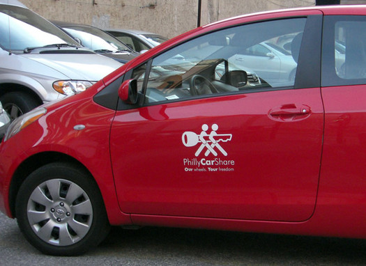
Capital CarShare, the group planning a non-for-profit car sharing org for the Capital Region, has put together a very detailed plan for the service. It includes explanations of how the service would work, neighborhoods where it would set, and projected finances.
The report is at the link above. It's also embedded after the jump.
The proposed service would include three membership levels (with discounts for yearly memberships):
+ Basic - $0/month, $9/hour, $0.25/mile
+ Silver - $10/month, $7/hour, $0.25/mile
+ Gold - $30/month, $5/hour, $0.25/mile
The plan also ranks areas in the order of expected roll out of the service over three years:
1. Downtown Albany, Center Square, and University Heights
2. Albany's Park South and Pine Hills neighborhoods
3. Arbor Hill, South End, and Delaware Avenue neighborhoods
There are a lot more details in the reports and it's worth taking a look if you're interested.
Earlier on AOA: Lauren Alpert talked about the car sharing plan on Soapbox back in June.
[via TSTC / thanks, Matthew]
Bike sharing
The city of Albany, Capital District Transportation Committee, bike-planning-famous consultancy Alta Planning and Design are (emphasis added) "conducting a study on what bike route signage is needed in the City of Albany and how bike sharing might be implemented here." There's a public meeting about the study next Monday (September 24) at The Linda at 6 pm. The blurbage says they'll also be looking for public input at the meeting. (Poster embedded after the jump.)
Multiple-week Fuller Road closure near Washington Ave
Florcle construction, as of Monday.
This should keep things interesting at the busy Washington Ave/Fuller Road intersection in Albany: Fuller Road will be closed between Washington Ave and the ramps for I-90 from today until the morning of September 25.* (Fuller will be open from the ramps north to Central Ave.)
If you've passed by there recently, you've probably noticed the progress on the new circle/flyover (we're calling it a "florcle") that's part of the re-alignment of Washington Ave. The road is being moved to open up space for Albany NanoTech.
*The message boards on I-90 yesterday said the road would be closed until September 23. The September 25 date is from NY511 (full text post jump -- it'd be great to be able to permalink stuff there).
Twin Bridges
Speaking of closures: the weekend closure of the northbound side of the Twin Bridges starts this Friday night. Northbound traffic will be routed over the southbound bridge. Both directions will be sharing the same bridge (heartwarming, right). That means there will be one lane for each direction, which will probably mean traffic backups at times.
This weekend is the first of six weekend closures as part of the deck replacement for the bridge. The southbound bridge will get the same treatment next spring.
The not-so-rapid rise of bus rapid transit
 There's an interesting article in Governing on the growing popularity of bus rapid transit systems (BRT) -- like CDTA's BusPlus. A short clip:
Generally, the thinking among U.S. transit officials is that "choice riders" -- those who don't have to take transit but opt to because of its convenience -- are willing to ride subways, light rail and streetcars, but not buses. Advocates of BRT argue that bus service itself isn't the problem; it's the way the service is implemented. Offer riders buses that are fast, clean and safe, they say, and passengers will embrace them. "If you build it right, people will come," says Janette Sadik-Khan, New York City's transportation commissioner. "People aren't going to get on dirty buses that are slow."
The article hits on the potential of such systems, but also their problems and critics -- including those who say that BRT is just a decision to "cheap out" on building more robust systems like light rail.
When transportation issues come up here, people often call out for light rail. But here's the thing: the chances of that ever happening in the Capital Region are very small. Building such a system would cost a ton of money (that Governing article mentions the projected cost of 7 miles of light rail in Cleveland was $1 billion). And it would be a political nightmare -- any worthwhile system here would cross numerous municipal lines, requiring the cooperation (or at least non-opposition) of a long string of county and local governments. It'd be like setting off an atomic NIMBY bomb.
BusPlus isn't perfect -- far from it. CDTA needs to keep adding features and make the system faster in order to at least fulfill its initial promise. And it will have to expand the service to make it more than a Albany-Schenectady express line. There's a long way to go. But it's probably the closest thing we'll get to a transit rail system.
[via @drewbkerr]
So people actually do get stopped for texting while driving
Almost 21,000 tickets for texting-while-driving were issued by police in New York State over the last year, according to numbers from the Cuomo admin. And, look, county-by-county numbers for the past year (year before that):
Albany County: 539 (75)
Rensselaer County: 163 (21)
Saratoga County: 326 (42)
Schenectady County: 69 (18)
(It appears that Albany County racked up that total thanks in part to a sweep this spring by the county sheriff's office that netted 230 tickets for talking or texting while driving. [Troy Record])
The totals were released to mark one year since the state law making TWD a primary traffic offense took effect. That means police can now pull a person over just for that -- before you had to be doing something else to get stopped (like swerving over the double yellow because you were sending email). And it looks like people are getting pulled over for it.
You might think you can text and drive with no problem -- we're all above average drivers, right (oh, wait...) -- but probably not. There's research that indicates a distracted driver is about as bad as a driver with a .08 blood alcohol level, which is the legal limit for drunk driving. (The New York Times produced a good series about the risks of distracted driving.)
All county totals after the jump, if you're curious.
photo: Flickr user mrJasonWeaver (cc)
An updated vision for high-speed rail
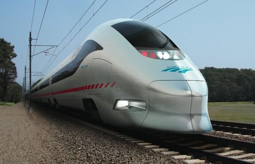
But those are some sleek trains...
Amtrak has released an updated version of its aspirations for high-speed rail along the Northeast Corridor. The short story: the new set of goals streamlines the plan, it's still expensive ($151 billion), and high-speed rail is still decades away. Transportation nation has a digest of the report.
The Empire Corridor doesn't figure into this plan. And despite whatever strong potential there might be for high-speed rail in the Hudson Valley, seeing Amtrak peg a target date for high-speed service along the Boston-NYC-DC corridor somewhere in the 2030-2040 range puts the chances of Albany-NYC service in perspective.
That said, it doesn't have to be 220 mph or nothing. There are a lot of improvements that could potentially speed up, and smooth out, Empire Corridor service (examples: reducing bottlenecks, upgrading crossings). Higher-speed rail (say, 110 mph) should be a reasonable expectation. And people would ride it -- the Albany-Rensselaer station was the 9th busiest Amtrak station in the country last year. Getting faster service along the Hudson Valley, plus high-speed service along the Northeast Corridor, could make rail travel from here to places like Philadelphia and DC a lot more attractive.
image: Amtrak
A few things about riding the bus
Please have your swiper ready when the bus stops.
The battery died. That's why I became a semi-regular bus rider.
When the battery finally conked out for good on one of our cars, it was going to be a day or two before I'd be able to buy a new one to replace it. And my wife needed the car the next day -- so I took the bus downtown.
That ride started a mostly unplanned experiment in becoming a one-car household. We had kicked around the idea of not replacing our older car whenever its time came to be donated/junked/Craigslisted. But talking about that and actually doing that are two different things. So, the dead battery was an opportunity to try it out.
We still have the car, but we haven't driven it in about two months. In that time I've become a semi-regular bus rider.
Here are a few things I've learned, remembered, or noted along the way...
Major construction on Twin Bridges late this summer/early fall
The state Department of Transportation announced this week that the $29 million project to replace the decks on the Twin Bridges (ahem, the Thaddeus Kosciusko Bridge) will start this month.NYSDOT says traffic disruptions will be "minimal" during the summer travel season.
The heavy work -- the stuff that sounds like something more than a minimal disruption -- will start in late summer. NYSDOT says the northbound bridge will be closed for six weekends so the decks can be replaced. Traffic will be routed in both directions -- one lane each -- over what would normally be the southbound bridge. The weekend closures won't start until after Labor Day.
The work will then switch to the southbound bridge for six weekends next spring.
The Twins carry more than 100,000 vehicles each day, according to NYSDOT.
Earlier on AOA: Kosciuszk-who?
On the bus. On the phone.
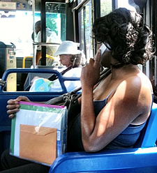 We were a little taken a back today when this woman pulled out an old-school phone handset on the bus -- and started having a conversation.
It turned out it the handset was plugged into an iPhone. The woman had what looked like a notebook and pen and other stuff -- just talking on the phone, getting stuff done, like she was in any office.
The bus is often more interesting than driving.
Something to be happy about: traffic
 Worth pointing out (again): the Albany metro area has a relatively low level of traffic congestion. In fact, compared to a lot of large metros, it essentially doesn't have traffic.
The Albany metro area ranked 78th for traffic congestion during the 12 months that ended in April 2012, according to the traffic data firm INRIX. Trips here on average took 2.1 percent more time because of congestion (down from 3.6 percent during the same period the year before). It estimates that the average driver here wasted 4.1 hours during that period because of congestion.
For some context: the most congested metro area last year was Honolulu, where INRIX figures drivers wasted 58 hours during the year. The Honolulu metro is roughly the same size as Albany-Schenectady-Troy in terms of population (Honolulu is #53, Albany is #59).
The time of the week with the most congestion? Thursday and Friday afternoon rush hour.
INRIX didn't identify any corridor bottlenecks here. The most congested corridor in the nation was a portion of the 405 in LA.
Austin: Q: Why did the semiconductor consortium cross the road to Albany? A: Maybe because it couldn't cross the road in Austin -- the Texas city had the 6th worst traffic congestion in the nation.
We're joking about that. Mostly. But there's research that traffic and commuting make people unhappy -- and that we often underestimate the degree to which it's a downer. [Wired]
Here's the INRIX explainer on methodology. Last year were able to find out which roadways it was tracking in this area -- we can't find that this year. (Last year it was I-87, I-90, I-787, I-890, and Route 7.)
Car sharing in the Capital Region

Zip Car's car sharing program is popular in other cities around the U.S.
![]() I'll admit it -- life in the capital region is a lot easier with a car.
I'll admit it -- life in the capital region is a lot easier with a car.
A car makes going on that big shopping trip, going apple picking or going for a hike at Thacher State Park a lot more convenient. While CDTA buses are a good option to get to many destinations, public transit doesn't take you everywhere you need to go, so a car can be a necesssity.
But a car can also be a headache -- and a lot of expense. Think about the amount of time the car you're paying for and insuring sits idle -- just waiting for you to decide to go somewhere.
Bundle your insurance, gas, parking and maintenance costs together into an monthly rate and it can add up pretty quickly. $300 a month? $500?
That's one of the reasons we're working on car sharing in the Capital Region .
Schumer on board with walkable, bikeable Livingston Ave Bridge
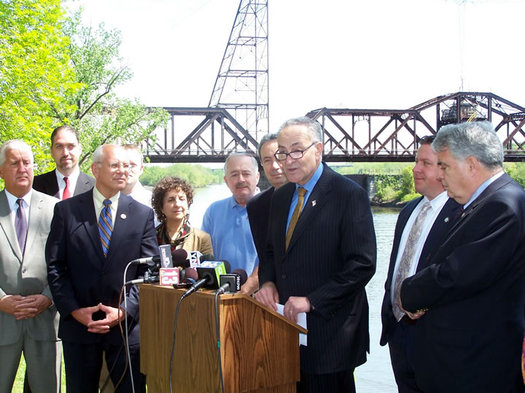
Chuck Schumer near the Livingston Ave Bridge today.
Chuck Schumer was in town today to push for the inclusion of a pedestrian walkway on the Livingston Ave Bridge -- regardless of what direction the project takes (rehab or total replacement).
Said New York's senior senator in a press release:
"For decades, people could easily walk over the Livingston Avenue Bridge and its sister, the old Maiden Lane Bridge, providing an important link between downtown Albany and the Rensselaer waterfront. ... Then all of that stopped, and the gates went up, shutting down the pedestrian link between these great cities. When the new bridge is built, we have a fresh chance to reconnect these two downtowns [Editors: Albany and Rensselaer] and funnel more visitors to key areas on both sides of the river. Failing to include a pedestrian component in this bridge would be shortsighted, and we can't make that mistake. That's why I'm urging everyone from CSX to Amtrak to NYSDOT to climb aboard with this plan, so that every design going forward will link up the biking and walking paths on both sides of the scenic Hudson."
In a Soapbox piece last fall, Martin Daley explained why local transportation planners are pushing for a pedestrian walkway on the bridge -- and the obstacles the idea has encountered:
Reconfiguration of Washington and Fuller starts
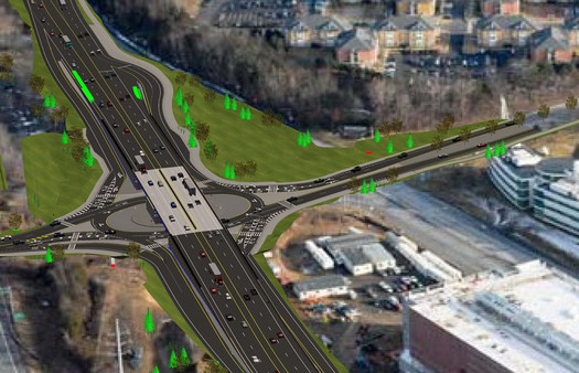
A rendering of the what the reconfigured intersection will look like.
The state Department of Transportation announced today that the realignment of the Washington Ave Ext/Fuller Road intersection has started. (You might have noticed the recent tree clearing around the site.) From the press release:
NYSDOT will realign Washington Ave. Ext. to the north and install a two-lane roundabout at the Fuller Road/County Road 156 intersection. A flyover bridge will be built to carry through-traffic, thereby removing 20,000 cars daily from the intersection and providing improved access to CNSE's Albany NanoTech Complex, which is currently engaged in a $366 million expansion project. Nearly 30,000 vehicles travel through the intersection each day.
Pedestrian and bicycle access will be improved with new sidewalks and a new, 10-foot bicycle lane that will connect to existing bike trails. Reduced congestion will enhance transit schedules; new bus bays on Washington Ave. Ext. will provide safer stopping areas for riders.
Most of the work can be done without impacting traffic. More than 3.5 miles of Washington Ave and Washington Ave. Ext. will be reconstructed, together with a half mile stretch of Fuller Rd.
NYSDOT says it's an $18 million project, funded by the Fuller Road Management Corporation -- a not-for-profit org created to manage the nanotechnology facilities at UAlbany's CNSE -- Albany County, and the state. It says FRMC is picking up 45 percent of the cost.
The project is expected to be "substantially completed" this fall -- with minor work on Fuller Road next summer. The re-alignment will open up more space for Albany NanoTech. (The area under the bridge that currently spans Wash Ave Ext will become a parking lot.)
Large-format renderings are after the jump.
So, what's this intersection called? We were hoping that a flyover bridge over a roundabout had a special name or transpo planner slang -- you know, like SPUI. So we checked with NYSOT spokeswoman Carol Breen -- and, alas, it does not. Of course, that's an opportunity to coin one. Florcle? FlyAbout? Roflyover?
Like sitting on the handle bars
Check it out: Rob Gierthy emailed us with a video he created of commute home via bike:
I have a small video camera attached to my bike that I record my commutes with. This past Monday was such a surprisingly nice day that I thought I would share it and uploaded the video to YouTube. It documents a slow ride up the sidewalk on Madison (I know I shouldn't be on the sidewalk, but the traffic is so congested there that it seemed safer), down and across Swan to Hudson, and then through Washington Park. It might not be that exciting but for me it is a celebration of the arrival of spring.
There's a surprising zen quality about watching the video. And the images (cinematography? biketography?) are beautiful in spots -- the wide angle lens makes the sky look huge.
A little more from Rob about his commute
I've been commuting by bicycle the two miles to my job at the Empire State Plaza for almost a year now. My initial plan was to keep going until it got too cold and then stop, but a combination of a mild winter and my stubbornness kept that from happening. Covered in wool from head to toe during those cold months I forgot how enjoyable biking actually is. Now that it is suddenly warm enough that I can bike in shorts and sandals it is a revelation. No longer is it a mental and physical struggle to fight the wind and cold. Instead it is fun and liberating. The warm breeze feels great and actually seeing people out reminds me that I don't live in a barren lifeless wasteland.
Here are more of Rob's commutes. A snow-filled commute video is embedded after the jump -- it's speeded up, so it feels a bit like a skeleton run.
"The Life and Death of Urban Highways"
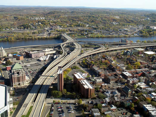
Another log for the "tear down 787" fire: The Life and Death of Urban Highways, a survey of why cities around the world have been tearing down urban highways -- and what has happened when they've done so. (Update: That link wasn't working for some reason Tuesday evening, so the report is now embedded after the jump.)
Among the reasons cited by the report that urban highways have fallen out of favor:
+ Costs of reconstruction and repair: Cities are finding out how much it costs to maintain these highways and are deciding the money is better spent other ways.
+ Economic revitalization: Removing the highways, which serve as dividers in the urban landscape, has opened the way for new development of neighborhoods -- and in many cases, higher property values.
+ Making accessible waterfronts: Many urban highways -- like 787 -- parallel waterfronts, and removing them reconnects the waterfronts to the city, again opening the way for parks, development, and higher property values.
The report also includes case studies from cities such as Portland, Oregon, San Francisco, and Milwaukee.
The orgs responsible for the report, Institute for Transportation and Development Policy and EMBARQ, advocacy orgs that both appear to be very much of the Jane Jacobs, pro-public transit school -- just something to keep in mind while reading through the report so grains of salt. It's interesting reading, and it's easy to see how many of the issues brought up could apply to the Capital Region.
The thing to keep in mind about 787 is that there's no "do nothing" option over the long run. If it stays, it has to be maintained -- and that's not cheap. If it goes... that's not cheap, either. So, the question really is: if we (the region/state) are going to spend (tens, hundreds of) millions on this key piece of infrastructure, what do we ultimately want to end up with? And is it worth it to us to spend more upfront to have something possibly better (though not necessarily guaranteed) in the future?
[via @SeanPCollins via Grist]
Earlier:
+ The removal of 787 in downtown Albany was on Martin's urban wish list
+ The Albany 2030 plan included a goal of evaluating possible alternative designs for 787
+ The Stakeholders org released a report last year that imagines the Albany waterfront with a boulevard (it's also embedded after the jump)
+ Syracuse has been considering the removal of the elevated portion of I-81 that runs right through the heart of the city [Streetsblog]
Yep, gasoline prices have gone up
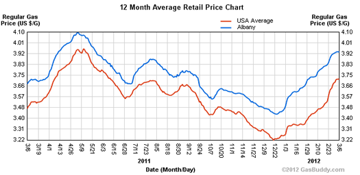
The blue line is the reported Albany area average price per gallon, the red the reported national average price.
Today's chart: From AlbanyGasPrices.com, it's a chart of Albany area gasoline prices over the last year.
In what's been painfully obvious if you've been filling up recently, there's a been a steep rise since December -- about 15 percent. But the recent run up follows what was more or less 8 months of declines. In fact, prices are still a bit below last year's high in April.
By the way: There are a handful of stations charging more than $4/gallon, according to AlbanyGasPrice.com's crowd-sourced reports -- including a station in Guilderland reportedly charging $4.16. The lowest price reported today in the core Capital Region was 3.83 in in Ballston Spa.
Taxes: The combined state and federal tax on a gallon of gasoline in New York State is 67.4 cents -- the highest in the nation. California and Connecticut are tied for #2 at 67 cents. [API]
[via @AndyArthur]
Earlier on AOA: March 2011: Everyone's taking a hit on gas prices -- sometimes even the gas stations
chart: AlbanyGasPrices.com
A pedestrian mall for downtown Troy?
Church Street, the pedestrian mall in Burlington, Vermont.
Potentially interesting: Troy mayor Lou Rosamilia has floated the idea of permanently closing some downtown streets to vehicle traffic in order to create a pedestrian mall, the Biz Review reports. [Biz Review]
The most famous recent experiment of this type has been in New York City, which has closed off sections of Broadway in Manhattan. [NYT] [NYT]
But the pedestrian mall isn't a new concept. Kalamazoo, Michigan first tried it in 1959. Many cities followed with their own pedestrian malls -- and a large majority of them failed. (Kalamazoo re-opened part of its mall to vehicular traffic in the late 90s.) There have been some notable successes, though. For example, Burlington's pedestrian mall, Church Street, is great. [Wikipedia] [Indianapolis Downtown Inc. study] [Kalamazoo Public Library]
The thing about a pedestrian mall area is that you need people. Downtown Troy has good foot traffic during the day -- it's maybe our favorite Capital Region downtown in daylight. Will there be enough people the rest of the time to make it worth it? Public spaces without people tend to go the wrong way. If the City Center and City Station projects are successful, maybe. [Governing]
Of course, there are a lot of details that would have be figured out for this idea -- which streets, how to address parking issues, how to address access for shipments to shops and businesses. But it's an interesting idea.
photo: Flickr user redjar
Park and plug in
The future. Maybe.
Kristofer spotted this electric vehicle charging station at the new ShopRite in Niskayuna. There are four spots in supermarket's parking lot designated for electric vehicles. Apparently Niskayuna town officials requested that ShopRite include the spots as part of its design for the store. [Spotlight]
The ShopRite charger brings the number of EV charging spots in the Capital Region to five, according to Dan Gibson at Our Energy Independence Community. In addition to ShopRite, there are stations at the Holiday Inn Express in downtown Albany, NYSERDA in Guilderland, the Saratoga Technology and Energy Park in Malta, and the HVCC Tec-Smart facility also in Malta.
Here's the thing, though: there are extraordinarily few electric cars on the road. The two currently for sale -- the Chevy Volt and Nissan Leaf -- are new on the market, and the technology -- especially for batteries -- could use some improvement. Most people probably aren't going to be keen to drive a car with a range of at most 100 miles in ideal conditions -- and much less in normal conditions. (To clarify: the Volt also has a gasoline engine, which can kick in after the batteries run out.) [NPR] [USA Today]
It's interesting/fitting that Niskayuna has an EV charging station made by GE, in an everything-new-is-old kind of way. Ace GE scientist Charles Steinmetz had an electric car all the way back in 1914. He used to drive it to his weekend home.
The Edison Exploratorium in Schenectady still has Steinmetz's electric car. There's video of it embedded after the jump.
(Thanks, Kristofer!)
Now on BusPlus: wi-fi, text alerts, bus tracking, queue jumping
CDTA announced today that it's added a bunch of digital tools for riders -- and the implementation of an important part of its "bus rapid transit" system.
First, the stuff for riders. Among the features that are part of "BusTime":
+ Predicted arrival times online for the next 2-3 buses
+ Real-time bus tracking on a map
+ Text alerts for bus arrivals
We tried out the tracking map this afternoon. It's kind of fun watching the buses move along the BusPlus route on Route 5.
Also: BusPlus now has wi-fi.
Queue jumping and signal priority
One of the touted advantages of BusPlus is that the buses will move along the Route 5 corridor faster than traffic (rapid, you might even say). And part of the system that theoretically makes that possible are "queue jumpers" and "signal priority." From the blurbage:
Queue jumper and traffic signal priority systems, considered key characteristics of bus rapid transit services, give buses priority at intersections, helping to improve traffic flow and enhance safety. Queue jumpers are short sections of "bus only" lanes that allow transit vehicles to "jump the queue" of waiting cars at congested intersections. The queue jumpers are installed and fully operational along Route 5 at three locations: Wolf Road Westbound, New Karner Road (West Bound) and Nott Terrace (Eastbound.) CDTA's first queue jumpers were introduced to the Capital Region in June 2003, and installed at the CDTA Fulton and 3rd and Fulton and 4th bus stops in Troy, New York.
Traffic Signal Priority employs technology that gives buses an extra 6 second lead-time ahead of other vehicles when running behind schedule. Traffic Signal Priority systems are installed at 44 intersections along the 17-mile corridor between downtown Albany and downtown Schenectady.
The video above demonstrates the queue jumper and signal priority in a virtual Colonie.
If all this stuff works, it should be pretty cool. And it's probably about as close to light rail as the Capital Region will ever get. CDTA plans to eventually expand BusPlus to the Western Ave and Washington Ave corridors.
CDTA route restructuring for Albany County
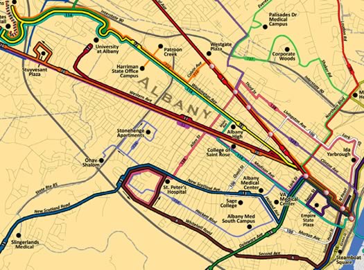
A clip from the reconfigured system map. A larger version is embedded after the jump.
CDTA is reconfiguring its routes in Albany County, starting on Sunday (November 13). The transit org is touting it as "the largest service change" in the authority's history. From the blurbage about the changes:
Improved Trunk Routes -- CDTA trunk routes operate seven (7) days a week, from early morning until late night. Customers using Routes #6, #7, #12, & #18 will see increased frequency, later night and New Sunday service and consistent trip patterns with no deviations.
New Neighborhood Network -- Neighborhood routes will improve service to destinations outside of downtown Albany by:
+ Establishing additional cross-town service
+ Increasing level of service on streets with high ridership
+ Providing new service to areas with high demand
Improved Commuter Routes -- Provide more direct, peak period connections throughout Albany County to customer-requested locations including Albany International Airport, Corporate Woods, Harriman State Campus, Ohav Shalom and Stonehenge Apartment Complexes along with Patroon Creek Boulevard.
You might have noticed the blue bags over route signs along the road -- this is what those are about.
Here's a listing of the new schedules. A map of the restructured routes is embedded after the jump.
CDTA says routes in Albany County represent "well over 50%" of its ridership. So this is a big deal. Even more so if it actually makes the system more useful to people.
The NanoBridge over Washington Ave Ext
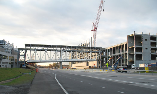
We'd say the bridge changes the character of that stretch, but it didn't have a lot of character to begin with.
Washington Ave Extension was closed this past weekend for the construction of a bridge connecting Albany NanoTech to its new building, the "NanoFab Xtension," across the road. For the infrastructure enthusiast, a few more large format photos are after the jump.
The Washington Ave Ext/Fuller Road re-alignment project will move Washington to the north so that it routes around UAlbany's College of Nanoscale Science and Engineering campus. The bridge will then span a parking lot for the college.
Seeing the bridge spanning the two buildings made us think back to a joke NanoEmperor Alain Kaloyeros made a few years back in Businessweek about expanding the campus so that he could walk to the Starbucks at Stuyvesant Plaza without going outside. What's a few more bridges...
Earlier on AOA: NANOvember
Amtrak adds wi-fi to Empire Service
 Amtrak announced today that there's now free wi-fi service on its Empire Service route, which travels from Buffalo to Albany to NYC.
The Empire Service is one of 12 routes to get wi-fi today. A few other locally-connected routes are also getting the service, though it will be limited to select cars: Ethan Allen Express (New York City - Rutland, Vermont), Adirondack (New York City - Montreal), and Maple Leaf (New York City - Toronto). Look for the wifi sticker (right) in the cars.
Amtrak already had wi-fi on Acela routes. Has anyone used it? (Update: Benita says she used it yesterday and "it worked just fine.") We're hoping it's better than the often dodgy service on the MegaBus. Amtrak says it makes use of mobile data networks to provide the service, and there's limited bandwidth among many of its routes.
Full press release with more details after the jump.
Earlier on AOA: The best way to get from Albany to NYC?
What's up at Washington and Fuller?
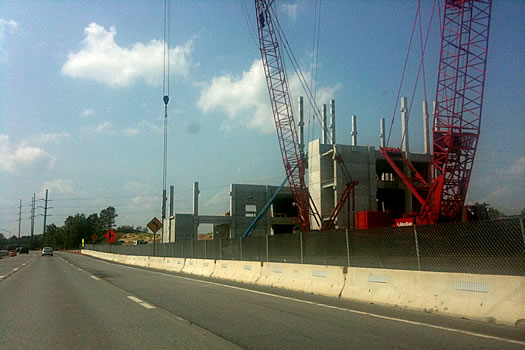
The nano empire expands.
You've probably noticed there's a lot going on at the super busy intersection of Fuller Road and Washington Ave in Albany. What with the hill that's now gone, and the large structure rising in its place, it's hard to miss -- whether you're driving along Washington, Fuller or the stretch of I-90 along there.
Here's what's up...
Getting there, directly

Its direct flight to Atlanta may be "direct" -- not direct.
After seeing this week that Southwest is adding a direct flight from ALB to Atlanta, we were curious about how many places we (or you or anyone) could fly directly from the Albany International Airport -- and how much it costs (versus a non-direct flight). [Southwest] [TU]
We're now boarding with the answer...
South Mall Expressway closed
The state Department of Transportation announced Wednesday night that it was immediately closing the South Mall Expressway -- that's Routes 9 and 20 between the Empire State Plaza and the Dunn Memorial Bridge -- because an inspection found cracks in beams that support the road. The full release -- with suggested alternate routes -- is after the jump.
Also part of the closure: the Madison Avenue off-ramp from I-787 south, the South Pearl Street on-ramp leading to the Dunn Memorial Bridge, and the part of Broadway between the Quay Street Connector and Madison Avenue.
The Dunn is still open, but down to one westbound lane (that is, heading toward Albany). Albany police say they expect backups Thursday morning, maybe as far back as Rensselaer. They're suggesting people use alternate routes if possible.
How long from here?
Fifteen minutes from Lark and Washington on CDTA.
This is somewhat interesting/fun: Mapnificient, an online mapping app, can project how far you can travel on public transit in the Capital District in a given amount of time. A screengrab is above. The easiest way to understand it is to just try it.
Mapnificient is the creation of Stefan Wehrmeyer, web developer in Germany. It reminds of us of similar maps we've seen for London.
Modestly useful in the Capital District? Sure. Fun to play with? Definitely.
[we're sure this is via someone... but we've forgotten... sorry]
screengrab: Mapnificient
The Albany residential parking permit task force recommendations
A totally unofficial estimate of the area to be covered by the parking permit system.
The task force developing the Albany residential parking permit system released its report and recommendations last week. The file that we received from Common Councilman Richard Conti, the task force's chair, is embedded after the jump.
The report includes many of the provisions Conti mentioned when we talked with him about the system in June. But there are few bits that caught our eye -- we've highlighted those.
If you live/work/visit the area around the Empire State Plaza, it's worth taking a look at this report. There will be a public comment period after an ordinance is introduced. There's also lobbying/emailing/stopping your council person on the street to talk about suggestions or changes. (And based on the comments from June, it sounds like people will have suggestions.)
The one-car household: a car junkie cuts back
![]() I am what you may call a recovering car junkie.
I am what you may call a recovering car junkie.
I. Love. Cars.
I've had over 10 of them -- even a couple of classics. And I still pine for the restored 1986 Jeep CJ-7 I once owned.
But a couple of years ago a muffler shop noticed a ton of frame rust on my barely-broken-in Toyota Tacoma and told me about a buyback program created to address the problem. After a month of back and forth, Toyota eventually bought my beloved truck back.
Since then, we've been a single car household.
Here's how it's worked out.
Pay and display in Albany
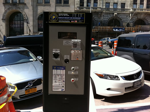
In a different context, "pay and display" could mean something completely different.
Albany has new parking meters downtown. Or, at least, it will have new parking meters. Right now, it hast just one, on State Street near Pearl -- and that's it above.
Unlike the old meters, the "pay and display" meter covers multiple spots. You pay for the time you want to park, print out a ticket, and then place it on your dashboard on the passenger side so parking enforcement can see it.
A few other bits about these new meters...
What's up with the Albany parking permit system?
A totally unofficial estimate of the area to be covered by the parking permit system.
It's been just about a year since the state legislature passed a bill allowing the city of Albany to set up a residential parking permit system near the Empire State Plaza. So, where's all that at now?
Albany Common Councilman Richard Conti is heading up the task force in charge of developing the system. We had a chance to talk with him last week about how the system is potentially shaping up...
Andrew Cuomo would like you to pay attention to the road
The Cuomo admin proposed legislation that would make it illegal to use any portable electronic device while driving (exception: phone with a hands-free device). From the release:
Governor Andrew M. Cuomo today announced he will introduce new legislation that will crack down on drivers caught using a portable electronic device including blackberrys, iPhones, i-pads, laptop computers, gaming devices and any other portable device, or talking on a cell phone without a hands free device, while driving. The bill would impose unprecedented penalties drivers caught using such a device by adding three points on a driver's license in order to curb the dramatic rise of this dangerous activity. Governor Cuomo's legislation would also make driving while using any portable electronic device a primary, rather than just a secondary offense, meaning that drivers can now be stopped solely if they are found to be using such a device while driving.
As it is now, you can't be stopped specifically for texting or phoning while driving -- you have to be pulled over for some over offense (say, crossing the double yellow because you weren't watching) and then you can be tagged for using your phone.
You might think you can text and drive with no problem -- we're all above average drivers, right (oh, wait...) -- but you're probably wrong. There's research that indicates a distracted driver is about as bad as a driver with a .08 blood alcohol level, which is the legal limit for drunk driving. (The New York Times produced a good series about the risks of distracted driving.)
The Cuomo admin hasn't posted the actual bill, yet, so there are still some questions. Among them: what about dashboard GPS devices (trying to find out where you're going can make you forget about where you're going). And automakers are starting to put dashboard computers into cars.
There's already a bill in the legislature that would make texting while driving a primary offense.
photo: Flickr user mrJasonWeaver
Where to rent a bike?
 Maya emails:
I wanted to know where I can rent bikes in the capital district region. I live in a small apartment with no balcony. Although I want to buy a bike, there is no space to keep it in my house.
Got a suggestion for Maya -- either for where to rent, or maybe how she might find space to store a bike? Please share!
Earlier on AOA: Where to buy a bike?
Look both ways
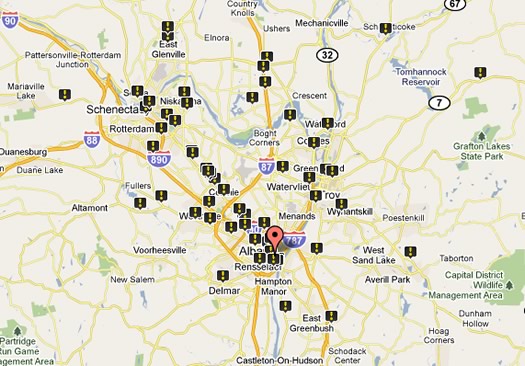
A screengrab from the map of pedestrian deaths in the Capital Region.
There were 92 pedestrian fatalities in the Capital Region from the years 2000-2009, according to a report out this week from a transportation advocacy org.
The Capital Region had one of the lower fatality rates in the state -- 1.1 deaths per 100,000 people. Of the four core counties, Albany had the highest pedestrian fatality rate at 1.3 deaths per 100,000 people.
Transportation America's report also includes a map of the pedestrian deaths. Of the 92 deaths reported in the Capital Region, 13 of them occurred along Route 5, according to the map.
[via @omarjpeters and @AbbyThyme]
New York gobbles up rail money Fla gave back
New York State is getting more than $354 million from the feds for rail upgrades around the state -- including right here in the Capital Region. [US DOT]
The feds are touting the money as funding for high-speed rail. That may be true in some cases -- a section of the Northeast Corridor is being upgraded so trains can travel 160 mph -- but it's probably more accurate to say the money is going to projects that could lead to high-speed rail. Here's the key local bit from the press release:
New York - Empire Corridor Capacity Improvements: $58 million to construct upgrades to tracks, stations and signals, improving rail operations along the Empire Corridor. This includes replacement of the Schenectady Station and construction of a fourth station track at the Albany - Rensselaer Station, one of the corridor's most significant bottlenecks.
The Empire Corridor is one of Amtrak's busiest routes. The rest of the New York State money is going toward funding a bypass in Manhattan intended to clear up congestion there, and a bit is going toward the study for a new station in Rochester.
Today's $2 billion in federal grants come from a chunk of high-speed rail funding Florida gave back last year. Governors from other states -- including New York -- basically said at the time, "If they're not going that eat that, pass it over to us." [Cuomo admin]
Earlier on AOA:
+ Will high-speed money train make a stop here?
+ Albany-NYC: strong potential for high-speed rail?
BusPlus launches
CDTA's new BusPlus service is now officially running along Route 5 between Albany and Schenectady.
BusPlus is a "bus rapid transit" system -- it features fewer stops than a regular route and "transit signal priority" at some intersections (that is, it gets to go through traffic lights), and upgraded stops. It's a bit like light rail -- but, you know, without the rails.
CDTA says the new Route 5 BusPlus line between Albany and Schenectady has 18 stops each way, as opposed to 90 stops on the regular line. It says the travel time should be shorter as a result.
The transit org says it picked Route 5 for the first line because it's the busiest travel corridor in the region and accounts for 25 percent of the system's boardings. It says it has plans to next expand the service to Western and Washington Avenues in Albany. There's a lot riding on BusPlus (pun intended) -- the total project cost for BusPlus is estimated to be $36.5 million (more than $16 million is coming from federal stimulus money).
The BusPlus fare will be $2 ($1.50 if you have a swiper card). But it's free the first two weeks. The buses are marked differently than the regular blue CDTA buses -- they're red and silver.
Has anyone tried it out BusPlus during regular service? We'd like to hear about it.
Traffic? That's not traffic.
"Travel time tax" by hour and day of week in the Capital Region in 2010
The Albany metro area has nation's 80th most congested traffic, according to the annual rankings compiled by a company called INRIX. Or, as people from most major metros might describe the findings: we don't have traffic here.
The Albany metro scored its #80 ranking despite being the 58th largest metro. This area has just one percent of the peak period congestion as the #1 spot on the list, Los Angeles. INRX figures that congestion caused trips on the Capital Region's major roads to take just two percent longer in 2010 than they otherwise would during free flowing traffic (compared to the 10 percent national average).
INRIX didn't identify any congested corridors or bottlenecks here. (The most congested corridor in the nation: the Cross Bronx Expressway.)
The worst traffic time of the week? Friday between 5:15 and 5:30, where trips take a whopping 7 percent longer than they otherwise would. Yes, you better call ahead to let them know you'll be a little late.
The survey only covered metro area's major highways (I-87, I-90, I-787, I-890, Route 7). Here's more on the methodology.
Earlier on AOA: Traffic lights and ants
graph: INRIX
The highway that was almost buried under Washington Park
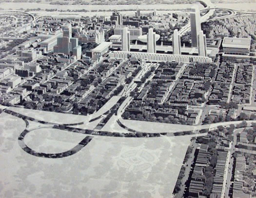
What could go wrong?
Ever wondered why the Dunn Memorial Bridge provides a ramp to thin air? Why the Livingston Avenue exit of I-90 is so overbuilt, and ends so abruptly? Why there are extra tunnels underneath the Empire State Plaza? Or why Corporate Woods has its own highway exit?
They're all vestiges of a highway system that was never built.
Blast from the past
All aboard! Next stop... the future.
We came across this photo today while getting Carl's piece about the Livingston Ave Bridge together. It's a locomotive from the old New York Central railroad -- the railroad organized by Erastus Corning (the great grandfather of the longtime mayor of Albany).
We love the sleek vintage futurism of the locomotive's design. It looks like a rocket ship from an old Flash Gordon flick.
The engines were designed by Henry Dreyfuss, one of the celebrity industrial designers of the 1930s and 40s. Among Dreyfuss' many notable designs is the classic "Lucy" telephone.
This streamlined engine design (the "Hudson") went into service in 1938 after being manufactured in New York Central's huge West Albany yard (the engine under the hood was produced by Alco in Schenectady). The stylish locomotives powered the famous 20th Century Limited line.
If/when New York ever gets high-speed rail, we kind of hope the engines look this.
photo: Robert Yarnall Richie via Southern Methodist University, Central University Libraries, DeGolyer Library
Will high-speed money train make a stop here?
The Obama administration announced today its intent to spend "$53 billion over six years to continue construction of a national high-speed and intercity passenger rail network." The announcement is short on details about where this funding will be directed, but during the next fiscal year it says $8 billion will be focused on routes that fit one of these descriptions:
* Core Express: These corridors will form the backbone of the national high-speed rail system, with electrified trains traveling on dedicated tracks at speeds of 125-250 mph or higher.
* Regional: Crucial regional corridors with train speeds of 90-125 mph will see increases in trips and reductions in travel times, laying the foundation for future high-speed service.
* Emerging: Trains traveling at up to 90 mph will provide travelers in emerging rail corridors with access to the larger national high-speed and intercity passenger rail network.
This system will allow the Department - in partnership with states, freight rail, and private companies - to identify corridors for the construction of world-class high-speed rail, while raising speeds on existing rail lines and providing crucial planning and resources to communities who want to join the national high-speed rail network.
We're guessing Albany/New York City would probably fall in the "regional" category.
A planning/policy org recently ranked the Albany-NYC route as being among the top one percent of all routes in the nation with the most potential for high speed rail. (The route is already the fifth-most traveled in the Amtrak system.) The post here on AOA about that ranking prompted some interesting conversation -- including people who weren't necessarily sold that high-speed rail would be a good thing for the Capital Region.
Earlier on AOA:
+ Albany-NYC: strong potential for high-speed rail?
+ The slow line to high-speed rail
+ The best way to get from Albany to NYC?
That frozen slush on the bottom of the car
Yuck.
Winter's enthusiastic effort this year has prompted us to consider many issues, among them:
What do you call that wedge of gray, frozen slush that sticks on the bottom of a car behind the wheels?
We've never heard a word for it, but it seemed like one would be useful. For example:
Friend: What are you doing?
You: I'm just kicking the (whatever the word is) off the bottom of the car. I hate that stuff.
So, in search of a name, we asked people on Twitter what's it called. There were many responses...
Albany-NYC: strong potential for high-speed rail?
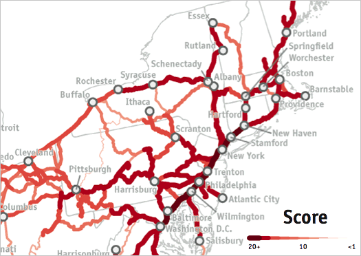
It's a hot route.
New York City to Albany ranks as one of the corridors with the most potential for high-speed rail, according to a report from a planning/policy org called America 2050.
The report assigned scores to almost 8000 rail corridors (of less than 600 miles) across the country based on group of factors including population, employment, and transit ridership. The NYC-Albany corridor ranked in the top one percent of all routes in the nation.
For some comparison, Washington DC-NYC was the top ranked route with a score of 20.15. The NYC-Albany route scored 19.29.
The report includes some really delicious transit nerding. Transportation Nation has a further breakdown of the results, including some thoughts on the effect of national politics (and circumstance) on current high-speed rail projects (or, how Florida could end up with the nation's first high-speed rail corridor [or not]).
As we understand the way these scores were calculated, corridors with already strong ridership tend to score best. So it's not surprising that NYC-Albany scored well -- the Empire Service is the fifth most-traveled route in the entire Amtrak system.
So, what could high-speed rail mean for Albany? Well, it could open the possibility of getting from Albany to Manhattan in about an hour (potentially). That's a commute for some people.
(Thanks, Kizzi!)
Earlier on AOA:
+ The slow line to high-speed rail
+ The best way to get from Albany to NYC?
image adapted from "High Speed Rail in America" by America 2050
Leave early
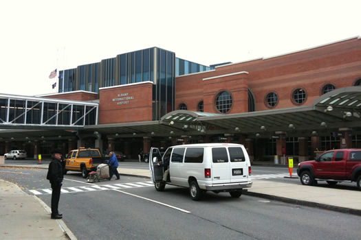
ALB is projected to be at or near capacity Wednesday.
Thursday is, of course, Thanksgiving. But Wednesday is The Day of Travel Frustration. A few things to keep in mind:
+ The NYS Thruway Authority says the two busiest days on the system are typically the Wednesday before Thanksgiving and the Sunday after. The peak travel time is noon to 8 pm. Yes, you almost certainly will have to wait at the Exit 24 tolls -- and probably any other major toll plaza.
+ ALB says the airport will be at or near capacity Wednesday -- and is urging people to arrive 90 minutes ahead of their flights' departure time in order to deal with the crush. [TU]
+ Amtrak is expecting Wednesday to be its single biggest day of the year. It says every one of its passenger trains will be in service that day.
So, leave early. Take a deep breath. You'll get there -- eventually.
Traffic lights and ants
 Interesting: Sanjay Goel, a UAlbany professor, has gotten a $378,375 grant to study how traffic light systems might be designed to produce emergent behavior. In other words, could traffic lights self-organize -- like ant colonies -- to enable better traffic flows.
From the press release:
Goel believes that each traffic light, like each ant, should make its own decision to communicate with the next light. That way, a driver crossing the intersection at midnight wouldn't have to wait for long minutes at a red light while there is no other traffic. ...
"The goal is to develop self-organizing algorithms and conduct simulation and modeling that would involve selection of intersections in Albany to test some algorithms," said Goel. "The focus of the study is to understand the limitations of this approach and find out where such techniques can fail or under what conditions we may get bottlenecks or chaos in traffic," he said.
Goel is looking for just the right intersections. "We will pick a variety of places where there is fast-moving traffic in the city," he said.
If someone can figure out how to make the traffic lights on Western Ave work together so as not to induce road-rage-levels of frustration in drivers along that stretch -- well, that person would deserve some sort of prize.
By the way: Have you stood next to one of the old traffic signal boxes around Albany (pic on the right)? If you listen carefully, you can hear the parts moving in there as the lights change.
[via @omarjpeters]
Bumper gawking
It's such a cute beast, though.
Yep, we admit it -- we like to gawk at custom license plates. And we know you do, too.
Here's a new bunch from around town...
Record year for Amtrak
Popular.
Amtrak announced this week that ridership was up 5.7 percent during the fiscal year that just ended compared to the year before. The rail org had a record 28,716,857 passengers.
Here are how some of the routes that pass through the Capital Region fared (rimshot):
The Empire Service gets a lot of traffic -- not just for here, but overall. In fact, it's the fifth most traveled non-Northeast Corridor route in Amtrak's system.
We're big fans of riding the train regionally -- it's our favorite way to get to NYC from Albany. Amtrak says it has a 65 percent share of the air-rail market between Washington and New York and a 52 percent share for air-rail travel between New York and Boston. The Northeast Corridor line had more than 7.1 million passengers last fiscal year.
By the way: Amtrak reports ridership is up 37 percent since FY2000.
Earlier on AOA:
+ The slow line to high-speed rail
+ The best way to get from Albany to NYC?
The slow line to high-speed rail
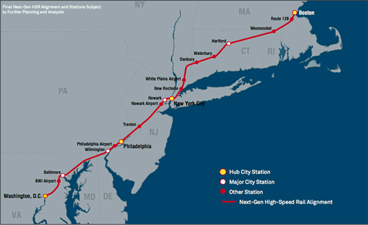
The proposed high-speed line along the Northeast Corridor.
Sometimes we have this transit fantasy in which the Capital Region is connected to other cities via high-speed rail. Headed for New York City? One hour. Boston? A one-magazine trip. Buffalo? Why? (We kid. Sort of.) It could have a profound effect on this region.
But the more this issue develops (or, you know, doesn't), we're thinking we might be traveling via jet pack before we get high-speed rail here.
Amtrak released a report on its high-speed rail aspirations for the Northeast Corridor yesterday. A few highlights:
Average speed: 140 mph
Washington to Boston: 3 hours
New York to Washington: a little more than 1.5 hours
Cost: $117 billion ($42 billion if it's all plunked down now)
Funding in place: no
Projected completion date: 2040
Yep, 30 years from now. And high-speed rail makes a lot sense along this corridor -- it's jammed with people and a lot of them already ride trains. Even so, the cost, planning and politics make the project a long shot. [The Transport Politic]
And despite all the talk about New York State hopping on board with high-speed rail, that's not looking likely, either.
Of course, things change. The political situation could shift. The economy could (somehow) get a lot better. The price of oil could way up.
Or not. So... where do we get fitted for a jet pack?
image: Amtrak
Visualizing the arteries of the Capital Region
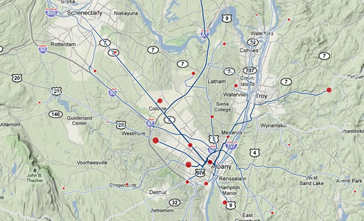
Commutes to 12210
This is fun/interesting to play around with: a designer/engineer named Harry Kao has built a visualization of commuting data for metros all across the country. You can sort the data by both zipcode and whether people are commuting from/to the zipcode.
 It'll make sense when you see it. For example, here's the map of the data for people who commute to 12210, which is in downtown Albany. And here's a map of the data for people who commute from 12065, which is in Clifton Park. The size of the dot in each zipcode represents the number of people coming from/heading to there.
You can zoom the maps, and view them on different backgrounds. It's kind of cool to view with a blank background -- the network of commuting routes look biological, like you're viewing an angiogram of the Capital Region.
Kao's mashup uses Census survey data from 2000, so it's a bit out of date (and he includes a few other caveats). But it's an interesting rough picture.
(Thanks, Amy!)
visualizations by Harry Kao
40 cent fare on CDTA Thursday
 Rides on CDTA will be 40 cents on Thursday. The transit org is offering the special fare to commemorate its 40th anniversary.
The fare is good on CDTA's regular route, STAR, and NX Northway Commuter buses. But to get the special price, you must to have exact change -- neither the drivers nor fare boxes can give change.
The Latham SPUI is now open
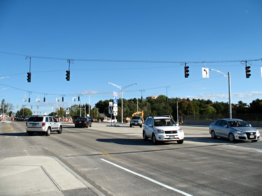
It's pronounced SPOO-ee.
The new configuration of the Exit 6 interchange in Latham opened today. It's the Capital Region's first single point urban interchange -- or, as its friends like to call it, a SPUI.
We stopped today around 5 pm to check it out. Traffic appeared to be moving through the intersection smoothly. Watching it for a few minutes, the flow has a certain grace to it, as the gently arcing lines of traffic slip past each other.
About that. Driving through the broad open area of the intersection didn't feel weird, but we could see how some people might not feel totally comfortable at first (though, really, it's not bad... just different). The state DOT has posted directions on how to the use the intersection, along with a diagram.
There are actually a few interesting bits in there. For example, the traffic lights on the "slip ramps" are there only for pedestrians (a pedestrian has to push the button to activate them).
The interchange isn't completely finished. But it looks good. More photos after the jump.
Update: Now with hot SPUI video.
(Thanks to Wendy to for the heads-up!)
For sale: one purple bookmobile
Vroom.
The Albany Public Library is selling its bookmobile, AKA "The Big Purple Bus." And it could be yours for the low, low price of just $10,000.
Here's the rundown on this very plum transport:
- Built in 1991 by Thomas, retrofitted by Matthews
- 3208 Cat engine, 8 cylinders, diesel
- 200,000 miles and 11,000 hours of use
- 36 feet long, titled as heavy truck
- Front and rear entrances
- Newer generator and 3 air conditioning units
- Can store up to 3,000 books in custom-built shelving
The APL has retired the bookmobile because it no longer needs it for outreach -- the system opened five new branch libraries over the last year.
Earlier on AOA: The best bang for your library buck
(Thanks, LB!)
photo courtesy of Albany Public Library
Should we punch the ticket for more expensive parking?
 People get very passionate about parking and seemingly all things parking-related: paying for it, permits, meters, shoveling. And these conversations almost always revolve around whether there's enough parking -- and whether it's cheap enough.
Well, in a NYT column this weekend economist Tyler Cowen pushes the case that in most places parking should be... more expensive:
Is this a serious economic issue? In fact, it's a classic tale of how subsidies, use restrictions, and price controls can steer an economy in wrong directions. Car owners may not want to hear this, but we have way too much free parking.
Higher charges for parking spaces would limit our trips by car. That would cut emissions, alleviate congestion and, as a side effect, improve land use.
Cowen goes on to talk about the work of Donald Shoup, a UCLA urban planning professor and the author of The High Cost of Free Parking. He continues the discussion on his excellent blog -- and responds to criticism.
Also via Cowen: San Francisco is testing parking meters that change the price based on current supply and demand.
By the way: Troy is considering residential parking permits for three of its neighborhoods. [TU]
Earlier on AOA:
+ Assembly passes Albany residential parking permits bill
+ Meters parked in Troy
+ The ethics of the shoveled parking spot
+ Ask AOA: Parking in Center Square
+ How the rest of us are ticketed
photo: Kim M
How much, where?
One the left, home prices as a percentage of median income. On the right, household median income.
Here's something that might help you kill time until you can leave work get a better picture of the Capital Region.
The Housing + Transportation Affordability Index is an online mapping tool that lets you apply all sorts of filters to local maps -- housing affordability, median household incomes, autos per household, transportation costs and so on. The maps are based on census data.
The index is a project of the Center for Neighborhood Technology, which promotes "more livable and sustainable urban communities." That viewpoint shows up in some of the explanations on the site.
[via Jen]
screengrab: CNT
Driving schools?
 Carl asks:
I wonder if anyone has any good experiences to share with Albany / Troy area driving schools. Because the do-it-yourself model is not working with my daughter.
We've always thought having your parent teach you how to drive is maybe not the best idea. There's just so much... baggage. (Red light! You don't have to use that tone with me. Brake! I am braking!!)
So, a suggestion here could really smooth the road. Please share!
photo: Naimi Grondin (Flickr user Naimi&virg)
Bumper gawking
 Updated with another pic!
As we've mentioned before, we plead guilty to a moving violation for dorkiness.
There are times that not only do we smile or note odd license plates around town -- we actually take photos of them, too.
Here's the most recent batch...
The car sharing conversation
 It sounds like Albany common councilwoman Leah Golby is trying to push things forward on car sharing. From an email she sent out on Friday (links added):
If you aren't sure what car sharing is -- the best way to describe it is: short-term car rental. If you've traveled to larger cities, you've likely seen ZipCar -- that's the large for-profit car sharing company. Car sharing is access to a car without the hassles of car ownership. Car sharing helps to reduce gas emissions, promotes use of public transit and can save you $ by (for example) down-sizing from a two-car household to a 1-car household. ...
I happen to be more in favor of locally-controlled non-profit car sharing for the reasons that an Austin group described on the attached.
Momentum for any car sharing company would need to work collaboratively with all of the colleges/ universities leaders from our neighborhoods with parking issues (Center Square/ Hudson Park and Pine Hills), the city's Planning Department and CDTA/ CDTC.
Golby is hoping to prompt discussion via a Twitter hashtag: #ImagineAlbanyCarShare.
Of course, something like this wouldn't have to be limited just to Albany -- there are probably a handful of neighborhoods/areas/centers in the Capital Region that might benefit from car sharing.
Updated July 29, 2010 to include link to the pdf.
Earlier on AOA:
+ Report: car sharing coming to the Capital Region. Sort of.
+ Assembly passes Albany residential parking permits bill
+ From 2008: Not-yet-councilwoman Leah Golby talked about living in the Capital Region without a car
photo: Flickr user Jason Rodriguez
Toy car
So, what is the preferred glue for sticking a figurine to one's hood?
While we're on the subject of art cars: we passed this car in the parking lot at Colonie Center this past weekend.
It's a compact Nissan with with figurines stuck to the hood. And the trunk was covered in chalkboard paint, with an accompanying bin of chalk. People had written messages all over the trunk (among them: "Freakin epic car dude!!!").
A few more pics after the jump.
The Vehigloo could be yours
The Vehigloo in 2009.
You may have seen the "Vehigloo" driving around town -- it's an art car designed to look like a rolling igloo.
And now the Vehigloo could be yours. The owners have posted it on Craigslist. For free. From their posting:
You will get more attention driving around in this super fun car than if you were driving a Ferrari. Honks, waves, screaming, mooning -- you name it. It is not for the super shy unless you are trying to come out of your shell. We counted that we were photographed 50 times during our 6 hour trip to Baltimore. That is once every 7 minutes! There is a PA system so you can make animal and siren noises. The inside is also decorated/painted including hanging icicles. This car has been in a bunch of parades. ...
We are looking to give this to someone who will either enjoy it as it is or change it into their own style of artcar. You are not going to get this car to look like a regular car again, so don't even think about it! :) PLEASE email me with your plans for the car.
As it happens, the Vehigloo is/was a 1991 Toyota Corolla -- and the owners say it needs some work.
Said Andreas, one of the creators, in a comment here on AOA last year: "I did it just for the fun of it. It is a unique experience to drive in something like this. Sometimes you feel like a rock star, and sometimes like a freak!"
(Thanks, StickFigureMan!)
NY City Bus update
Still a pretty cheap ride.
The NY City Bus line has raised its Albany-New York City fare to $20 each way. When we talked to a rep this afternoon, he said the $10 fares had been a promotional rate (not entirely surprising... it was really cheap). He said there's now a $5 discount when you book a roundtrip.
Thirty-five bucks to get to and from NYC isn't a bad deal. But it's a lost closer to the Megabus fare (anywhere from a few bucks if you're really lucky, to about $50) and the Dragon Deluxe (running its own $35 promotion right now).
Kalyn recently talked with a few people (among them, Albany Jane) about their NY City Bus experience -- and they sounded reasonably happy. Though, as a few commenters noted, the extra bucks for the Megabus do you get a few extras (air conditioning, wifi).
Good to know: NY City Bus is planning to start service from Saratoga Springs. The fare currently listed on the schedule is $20. The listed pickup point is near the Saratoga Springs Visitor Center on Broadway.
The rep we spoke with said they're hoping start the service August 1, but it could be later. He said their website would have the date when it's confirmed.
(Thanks, Andrew)
Earlier on AOA:
+ What's the new $10 bus ride to New York like?
+ NY City Bus -- competition for the MegaBus?
+ The best way to get from Albany to NYC?
photo: Albany Jane
What's the new $10 bus ride to New York like?
A cheap ride.
As of today, the NY City Bus -- which runs between Albany and New York for just $10 each way -- has been up and running for a month.
So we thought now would be a good time to track down some people who've ridden the bus to give us the scoop...
Assembly passes Albany residential parking permits bill
The approximate area covered by the 3/4 mile radius. Not every spot will be subject to the permits.
The state Assembly has passed the bill that would allow the City of Albany to run a trial residential parking permit program around the Empire State Plaza. From Albany Common Councilman Richard Conti's Facebook status last night:
Albany Permit Parking Bill just passed the Assembly, 80-45! Thanks to Assemblymembers McEneny and Canestrari for their efforts on moving this forward ... now it moves to Governor Paterson for approval.
The bill passed in the state Senate last week.
Among the bill's provisions:
+ The City of Albany would be allowed to "pilot a residential parking permit system with a two year sunset" within a 3/4 mile radius of the ESP.
+ No more than 2,750 spaces would be made available by permit in the permitted area. (The bill figures there are about 9000 spaces total in the affected area.)
+ Permit parking would not be allowed on streets where adjacent properties are zoned for "commercial, office and/or retail use."
+ At least 20 percent of the spaces in the permit would be available for non-residents to use for at least 90 minutes at a time.
(Thanks, Mike and others!)
Update: From a PEF press release:
The New York State Public Employees Federation (PEF) is disappointed state lawmakers have passed the Albany Permit Parking Plan, pandering to a small group of residents while shunning the needs of the general public.
The union is calling for Paterson to veto the legislation.
Earlier on AOA: Is the brake coming off residential parking permits near the ESP in Albany?
Is the brake coming off residential parking permits near the ESP in Albany?
Not every street within the proposed area would be subject to residential parking permits
Via Bob Conner comes word that a bill allowing residential parking permits near the Empire State Plaza is moving through the legislature again.
The bill passed in the Assembly a year ago, but died in the state Senate. Bob reports that Neil Breslin says it looks like there will be enough votes to pass it this time around in the Senate.
Among the bill's provisions:
+ The City of Albany would be allowed to "pilot a residential parking permit system with a two year sunset" within a 3/4 mile radius of the ESP.
+ No more than 2,750 spaces would be allowed in the permitted area.
+ Permit parking would not be allowed on streets where adjacent properties are zoned "commercial, office [and]/or retail use."
(The full text of the bill's provisions is after the jump.)
One possible hitch: the Assembly version of the bill differs from the Senate version in the size of the allowed area for permits -- 3/4 mile vs. 1 mile. Bob reports that CSEA dropped its opposition to the bill because of the reduced radius. Update: Albany common councilman Richard Conti stopped by in the comments to note the Senate bill is identical to the Assembly bill and includes the 3/4 mile radius (it appears the Open Senate entry for the bill hasn't been completely updated, yet).
Jerry Jennings told AOA last October that he wants permit parking -- and would pursue it if the legislature allowed it.
Report: New Yorkers are the least knowledgeable drivers
That's quite some company for New York in the slow lane.
A nationwide test/survey concluded that drivers in New York State are the least knowledgeable in the nation.
The test, which was sponsored by GMAC Insurance, asked drivers a series of 20 questions that were taken from state DMV exams. The New Yorkers' average score was a 70 -- the worst of any state (including DC) and just good enough to be considered passing (under 70 was considered failing).
Here's an explanation of the methodology.
This is the second year in a row that New York was ranked last in the nation. Other states near the bottom: New Jersey (shock), DC, California and Rhode Island. The Empire and Garden states have ranked near the bottom for the past five years.
Kansas had the top average score (82.3). The national average score was 76.2.
[via CapNews9]
Earlier on AOA: Listomania: a list of lists which list the Capital Region and New York
map: GMAC Insurance
Exit 6 closed this weekend
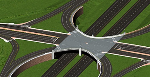
We admit it: we like to say "SPUI."
Just a reminder that Exit 6 on the Northway in Latham will be closed this weekend for construction on the SPUI. The ramps to/from I-87 are scheduled to close at 10 pm Friday night and open back up at 6 am Monday. There will also be lane closures on Route 7.
In other words: avoid, if you can. Here's a list of detours.
This weekend's work on the SPUI "marks a major milestone in the project and the approximate halfway point in this year's work," according to the state Department of Transportation. Barring any "unforeseen issues," the agency is projecting the interchanged will be open in the new Single Point Urban Interchange configuration "sometime in October 2010." The whole project is scheduled to be finished in 2011. Total cost: $41.9 million.
Oh, yeah: Not only does Exit 6 have its own website (Exit6.org) -- it's also a check-in location on Foursquare: Exit 6 Cluster F*ck. (Ouch.) The mayor is Jerry (@derryX).
Earlier on AOA:
+ Talkin' about SPUIs
+ It's pronounced "spoo-ee"
image: NYSDOT
NY City Bus -- competition for the MegaBus?
A new bus service between Albany and NYC started up today. The aptly-named NY City Bus is selling one-way rides to/from the city for $10.
That's cheap -- even cheaper than the MegaBus in many cases. A round trip ride on the MegaBus this week will cost you $60 if you bought now. (You can get it for as little as $18 if you book the same ride for a month from now.)
We had never heard of NY City Bus until recently, so we did a little bit of poking around -- and it looks like the bus line has a lot of similarities to the DragonDeluxe line. There are so many similarities that we wonder if it's connected to the Dragon. It shares the same pick-up (91 Colvin Avenue and 102 Central Ave in Albany) and drop-off (26 Canal Street and near Port Authority Bus Terminal in Manhattan). And the two services seem to use one of the same operators (All State). The NY City Bus corporation was registered this past March and the listed address in Chinatown in Manhattan is different from that of the company that runs Dragon Deluxe, according to the listing on file with the state.
The Dragon Deluxe fare is roundtrip fare is more expensive -- $40 vs. $20. The NY City Bus site doesn't list the $20 fare as a promotion or sale or anything like that.
The NY City Bus lists a handful of routes around the country. Has anyone ridden it before? Anyone have the scoop?
Earlier on AOA: We broke down the travel options between Albany and NYC by price, time and ease.
image: NY City Bus
The CDTA iPhone app
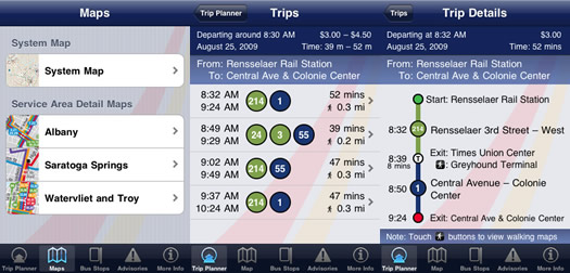
Screenshots from the app.
CDTA released an update to its iPhone app this week, so we decided to check it out. And it's pretty cool.
The app has four primary functions: map, stop finder, trip planner, advisories. The map alone would be worth a download, but the other functions are helpful, too -- especially if you don't ride the same route all the time or you're not a hardcore CDTA rider.
At the pump
The chart above is from AlbanyGasPrices.com, the crowd-sourced gas prices site. It tracks the average price for a gallon of regular gasoline in the Albany area over the past year. The price has backed off during the last week or so, but it's still just about at the high for the last year.
If you go to the Albany Gas Prices site, you can graph the price against the national average (it tracks pretty closely) and crude oil prices -- and over different time spans, too.
AAA also tracks this data for the metro area, but without the graphs (and who doesn't love a graph).
The federal Energy Information Administration forecasted today that average gasoline prices will increase about four percent over the next year.
[prompted by a tweet from @AndyArthur]
Earlier on AOA:
+ From 2008: Gas hits four dollars and everyone's squeezed
+ How many gallons per mile?
+ Save money on gas... at Price Chopper?
graph: Albany Gas Prices
Can cars and bikes coexist in the Capital Region?
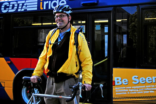
Tom Benware
Tom Benware might have passed you in traffic. On his bike. Which was on the side of a bus.
Tom appears on a CDTA bus as a part of a new initiative launched in April encouraging Capital Region motorists and cyclists to share the road.
In real life, the Delmar resident is a transportation guru, public transit advocate and 1,000-mile-a-year cyclist. He worked at the state Department of Transportation for 14 years and now he's the senior legislative analyst for the New York State Senate Transportation Committee. Just last week he helped advance new legislation that would require New York roads be designed with all users in mind - not just drivers.
I took a moment to talk with Tom about biking in the Capital Region, his favorite places to ride and what it's like to see yourself on the side of a bus.
Report: car sharing coming to the Capital Region. Sort of.
A Zipcar in Portland, Oregon. The program at UAlbany will be run by Hertz, according to the ASP.
The ASP's Jon Campbell reports that car sharing is coming to UAlbany via partnership with Hertz.
Over the last few years we've heard a handful of people -- online and off -- express their desire for car sharing here in the Capital Region.
A mixed case for street signs
Also, don't go that way on Marshall.
After D mentioned the new mixed-case street signs on the reconstructed section of Delaware Ave in Albany, B went out a took a photo (you can see the old-style all caps signs in the background of the large version).
Both D and Summer commented that the new mixed-case signs are hard to read. Wrote Summer: "It makes no sense to me, because all you see is a big "D" and the rest is tiny."
As CapHwys noted, mixed-case lettering on street signs is now a standard in the latest edition of the Manual on Uniform Traffic Control Devices, the bible for road signs. There's research from as far back as 1950 that using mixed-case, as opposed to ALL CAPS, is easier to read. (Although, the gains from lower case letters apparently drop off when people aren't sure of the word they're looking for.)
Earlier on AOA:
+ Next exit: the correct lettering?
+ Next exit: illegibility
photo: B
Next exit: the correct lettering?
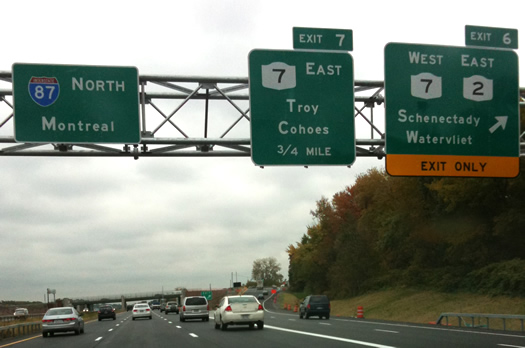
It just looks wrong.
It sounds like state Department of Transportation is finally on the case of the rogue typeface on the Northway signs near Exit 6. Said DOT spokesperson Peter Van Keuren in a quote at the TU's Getting There blog:
"... the lettering on these signs is not standard as a result of an error that was made by the consultant," he said. "New signs with the standard font will be installed at no added expense to the state."
What's odd about this situation is that there are clearly defined guidelines about how text should appear on interstate signs. Also, the new signs don't appear to use Clearview, the easier-to-read typeface being used on new interstate signs around the country.
It would be interesting to find out who this consultant is (seemingly not a font nerd) and what other projects they've been consulting on.
(Thanks, Fred!)
Earlier on AOA: Next exit: illegibility
Thruway scheduled to be widened in Albany
The NYS Thruway Authority announced today that it will be spending $110 million to reconstruct and widen the Thruway from Exit 23 (Albany, I-787) to Exit 24 (Albany, I-87). The plan is add one new lane in each direction -- which would bring to the stretch to three lanes on each side.
A mini-site for the project says construction is scheduled to start in mid-2011, with completion scheduled for 2012. It says no detours are expected -- a temporary lane will be added to the median during construction.
That stretch of Thruway runs along the back of a bunch of residential neighborhoods. The "project is not anticipated to directly impact adjacent land uses," according to the site. It does report that the extra lanes "may increase noise levels." The document says noise will be monitored and some sort of sound mitigation might be an option (example: noise walls).
The Thruway says a 2002 study reported that an average of 48,100 vehicles traveled on that stretch daily. That study concluded that northbound traffic operated at an "unacceptable Level of Service" and southbound traffic was projected to reach that point in... 2008.
Update: The TU reports the project is scheduled to start April 2011 and be finished in the fall of 2013. The project's chief engineer told the Gazette that stretch of Thruway is in "in significant disrepair."
The Thruway also announced today it will be resurfacing pavement on the following stretches:
- from milepost 121, south of Interchange 21B (Coxsackie) to milepost 141 near Interchange 23 (Albany, I-787)
- from Interchange 24 (Albany, I-87) at milepost 148.15 to west of Interchange 25 (Schenectady, I-890) at milepost 153.85
- nearly seven miles of pavement resurfacing and safety upgrades on the Berkshire Spur, from the Canaan Toll Barrier to the Massachusetts State Line, approximately $7.5 million.
Price Chopper gas discount for CDTA fares
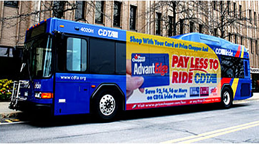
$50 at PC = $2 off a CDTA pass
Price Chopper has extended its Fuel AdvantEdge gas discount program to CDTA fares.
Here's how it works: This discount is based on 10 cents/gallon up to 20 gallon discount for gas. So for every $50 you spend at Price Chopper (while swiping your AdvantEdge card, of course), they'll knock $2 off the price of an eligible bus pass (31 day rolling, 10 day trip, Star tickets). Spend $100, save $4 on a bus pass. Spend $150, save $6. And so on. (As with the discount for gas, the credits can be used once and expire after 90 days.)
Here's a brochure that lists all the details.
The Chopper and CDTA are touting this program as maybe the first of its kind in the nation. They're running it for a 90-day trial period (now to May), "with the option to continue contingent upon its success."
photo: Price Chopper
How many gallons per mile?
 There's a bill in the state Senate that would require all new cars sold or leased in New York to come with a sticker that lists the autos' gallons-per-mile. Yep, that's gallons-per-mile -- not just miles-per-gallon.
So, why GPM?
Exit 6 construction delays
The end product. But, you know, with cars.
The construction of SPUI at Exit 6 on the Northway is set to start back up in March -- and it looks there will be delays. Lots of delays.
The DOT says it will be closing three lanes of the Rt 7 bridge. That should constrict things considerably for the 45,000 cars that pass through that point every day. The DOT is also planning a handful of weekend closures of on/off ramps at the exit, starting in March. [WTEN] [Fox23]
In other words: avoid. The Exit 6 web site includes a list of alternate routes through the surrounding area.
Earlier on AOA:
+ The Latham SPUI now has its own website
+ Talkin' about SPUIs
+ It's pronounced "spoo-ee"
The best way to get from Albany to NYC?
The Megabus wasn't an option the last time we did the math on this.
To New York City and back is a pretty common trip for people in the Capital Region. So... what's the fastest way? What's the cheapest? What's the best?
We ran the numbers almost two years ago -- but things change. So we did the math again, this time with even more detail.
The full breakdown after the jump.
Potholes ahead

Think of them as spontaneous transit art.
The condition of roads in the Albany area costs an average driver $1,145 a year, according to a research group called TRIP. The think tank came to that conclusion as part of an overall survey of New York State's surface transportation system.
Here's how TRIP breaks down the cost of the condition of the Capital Region's roads:
Final bicycle master plan presentation tonight
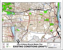 The final bicycle master plan for the City of Albany is scheduled to be presented tonight. From the flyer for the event:
The City of Albany, in partnership with the Capital District Transportation Committee (CDTC) is finishing a Bicycle Master Plan to identify a network of bicycle routes to help make cycling a more viable way of getting around the City. On Tuesday, October 27th, 2009, the final meeting will present the final plan, concept goals and priorities, maps, and detail graphics to clearly and logically incorporate bicycling into the City and region's overall transportation network.
The presentation starts at 7 pm in the large auditorium at the main branch of the Albany Public Library on Washington Ave.
CDTC has some info about past public bike plan meetings posted online, though it doesn't look like there's anything posted for tonight's presentation.
Update: here's the final draft report, via daleyplanit.
(Thanks, daleyplanit!)
Traffic on Route 7 at Exit 6
Avoid
What the state DOT is calling a "major road work event" began this week on Route 7 near Exit 6 on the Northway. The project has temporarily re-routed Route 7 west of the Northway.
If last night's traffic is any indication, the situation will be a mess all week. The westbound traffic was backed up into the box for the intersection for the off-ramp from I-87N. And people were being less than conscientious about clearing the intersection. There was honking.
You might want to avoid that stretch if you can. Route 155/Albany-Shaker (Exit 4) will take you around the south side of the airport and drop you off beyond the construction on Route 7.
Earlier on AOA: It's pronounced "spoo-ee"
Next exit: illegibility
What's that say?
Updated Tuesday evening
While we wouldn't exactly consider ourselves font nerds, we do notice typography. And the interstate signs that have gone up near Exit 6 on the Northway have been bugging us.
On time, most of the time
A few interesting local bits from a Brookings Institution report out this week about air travel delays:
Arrivals
ALB was on pace for about 1.3 million arriving passengers this year. That's down more than 5 percent from last year and almost 6 percent from five years ago. But it's up 42 percent from 10 years ago.
On time
Arrivals at ALB were on pace this year to be on time 78.5 percent of the time. That ranks #54 among the top 100 metros. And it was just about even with the national average (78.9 percent)
Delays
The average time of delay for a late arrival was on track to be 54.2 minutes this year -- that ranks 37th best among the top 100 metros.
Brookings also figured out the top 10 air corridors linking to the Capital Region. That list is after the jump...
CDTA route and stop changes
 CDTA is in the process of pruning its routes. Some lightly-used lines are being pared back. And some stops are being consolidated to "reduce travel-times and improve on-time performance."
The list of changes is after the jump. It looks like most of the stop consolidations will be in Albany and Troy.
"Driving" your bike with Tamara Flanders
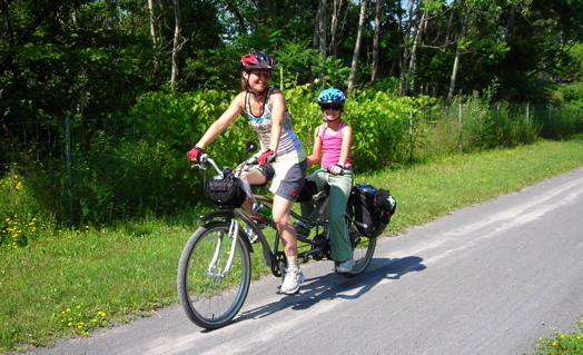
Tamara Flanders and her daughter on their tandem bike
We'd like to bike more in the Capital Region. Really, we would. But frankly, we're a bit, well, chicken. OK, maybe not exactly chicken. It's just that riding a bike in an area with few bike lanes and often-inconsiderate drivers seems a bit hazardous.
Which is why Tamara Flanders new class on how to "drive" a bike looked interesting to us. Flanders is a holistic health teacher who added a class for novice adult cyclists to her repertoire this spring.
Change in the CDTA driver's seat
We're still awaiting on official confirmation, but word is Ray Melleady, CDTA's executive director, is resigning at the end of this month to take a job in the private sector. (Melleady has apparently now confirmed this to the Daily Gazette.)
There's been a lot going on at CDTA over the last few years. The single-ride fare went up 50 cents in April. Ridership has been trending upward. And the org is working on its new Bus Rapid Transit system that will run along Rt 5 between Albany and Schenectady.
Melleady's farewell email after the jump.
(Thanks, Anonymous and others)
On tweeting while driving. And eating babies.
 From Cassie's Twitter stream Tuesday afternoon, a cautionary tale 140 characters at a time:
Tweeting a response to @B_Nut got me pulled over [on Wolf Road]. Telling the officer "I wasn't texting. I was Tweeting." is not recommended.
Happy Birthday, Thruway
![]() The New York State Thruway was born on this day in 1954 when its first section -- a 115 mile stretch between Lowell and Rochester -- opened.
The New York State Thruway was born on this day in 1954 when its first section -- a 115 mile stretch between Lowell and Rochester -- opened.
In honor of the Thruway's 55th birthday, here are a few facts about New York's ribbon of asphalt...
Ask AOA: car mechanics
 Update: We collected all the recommendations people posted into a list and map.
Emails Alex:
I've recently started to experience some car trouble. I'm relatively new to the area and none of my friends have been here long enough to recommend a good, independent mechanic. I've overpaid at chain shops for too long and I don't want to go to a dealer--can AOA recommend an honest mechanic!?
Anyone have suggestions?
photo: Flickr user Mess of Pottage
Bus error in your favor
We heard from a few people this morning that their CDTA ride was free because something was wrong with the fare boxes on the buses.
It sounds like this was just a case of the transit rider gods smiling briefly upon Albany. We checked the situation with CDTA's Margo Janack -- she emailed back this afternoon:
The issue occurred this morning (just on Albany buses) while the farebox computer system was being downloaded with updated software. It was fixed within the computer system just a few minutes after the glitch occurred, but the Albany buses were all ready out servicing customers and could not be individually probed until they came back in later this morning. The situation is completely remedied at this time.
(Thanks, Anonymous and others)
The Commuter Contest
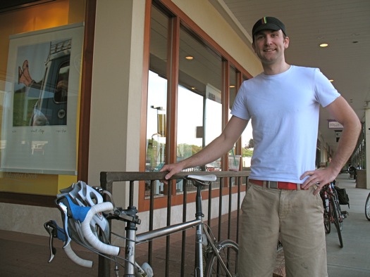
Willem Heydendael won the contest last year.
The New York Bicycling Coalition is holding its annual Commuter Contest this Thursday. From the org's press release:
This exciting competition pits bicyclists against motorists and transit riders during rush-hour traffic to determine the most efficient means of transportation. This friendly contest is designed to highlight the merits of a bicycle as a form of clean, low-cost, zero-carbon form of transportation. For the past 5 years, the bicyclist has been the winner--join us this year to see if we can make it 6 in a row!
(Results from last year's competition.)
The first 50 people to enter this year's competition will get a free safety light.
The dash starts at the Starbucks on North Pearl in downtown Albany at 5 pm and ends at the Stuyvesant Plaza Starbucks (that's 5.2 miles, according to Google).
Bonus bike fun: There's a showing of Veer, a documentary about Portland's thriving bike culture, at the Madison Theater Thursday night.
Bonus alternate transportation item: that commuter cruise between Albany and Troy is on Wednesday this week.
City treasurer received ghost tickets, it's good to be a lobbyist, problems at the Muddy Cup, Chopper uses AdvantEdge cards to notify of recall, Fallon was quizzed for final credits
Albany city treasurer Betty Barnette has testified that she had no knowledge of the ghost ticket system until she read about it in the news -- but the TU has obtained copies of seven no-fine tickets given to... Barnette. She says she has no memory of receiving the tickets. [TU] [CBS6]
Firms that lobby the state billed their clients almost $174 million last year. NYSUT spent $4.4 million -- the most of any single group. [Biz Review]
Chuck Schumer and Kirsten Gillibrand are apparently becoming BFF. He's even memorized her mobile number. [NYT]
The Saratoga County towns that had sued to hold up the Hudson dredging over concerns about their drinking water supply have dropped their suit. The dredging project is scheduled to start this month. [Daily Gazette]
What was with all the traffic?

Was it her fault?
So, yesterday wasn't exactly the best traffic day in the Capital Region.
Part of Rt 9 was shutdown near the Crescent Bridge during the morning commute because of the Saratoga Winners fire. Salt filming tied up things downtown in the evening -- and apparently Dane Cook's appearance at the TU Center didn't help. I-90 was apparently jammed, too. And Western Ave was backed up.
The downtown tie-ups are understandable. But why I-90 and Western? Anyone know the scoop?
By the way: what we call "traffic" here is what most metropolitan areas call "a few people on the road." Albany/Schenectady/Troy ranked 75th among the 100 biggest metros last year for traffic congestion. The rankings are from a firm called INRX, which uses GPS data to measure traffic. According to their data, Thursday from 5-6 pm was the worst travel hour in the Capital Region in 2007.
Here's what Google's traffic map says a typical Thursday evening commute looks like.
Traffic reports via @rmadeo, @justincresswell, @johnbulmer, @tenner, and @brianzimmel.
photo: World Economic Forum
Western Ave near Winthrop in Albany
Sure, you might call them "potholes."
But we prefer to think of them as spontaneous works of public transit art.
Art on the move
A few points about all this.
The Central Ave BID and CDTA are looking for artists to create public works for the new Bus Rapid Transit system that's being constructed along Route 5. It sounds like they're open to pretty much anything:
There are many concepts that could meet the criteria and consideration for public art. Public Art could be simply a metal insignia or representational tiles or words as concepts embedded or attched to nearby sidewalks, buildings, the bus shelter or who knows. Art for this project could even be considerd a multi-media interactive projector that displays art on nearby buildings, or it could be music or sounds. It could be tactile pads, buttons, braile or something that you touch or listen to. You are the artists, and therefor in the medium you are familiar with, tell us your ideas.
Other cities have done some really interesting stuff with transit art. The MTA has an ongoing "Arts for Transit" program. And Flickr is full of examples from around the world.
The first deadline for submissions is April 17. There are a bunch of other details posted on the project's site.
Towns sue EPA over dredging, stimulus money headed for local schools, comptroller takes up ghost ticket investigation, big hospital merger, home prices down
A handful of municipalities in Saratoga County -- including the county itself -- have sued to stop the EPA's Hudson River dredging project. The governments argue the feds have not adequately guaranteed people in the county will have a safe supply of drinking water during the project, which is scheduled to start in May. State senator Roy McDonald told a meeting last night that the EPA is "taking advantage of us" and said people should tell the feds to "go to hell." [TU] [Daily Gazette] [Post-Star]
Chuck Schumer says about $50 million in aid for schools is headed to the Capital Region from the federal stimulus bill. The Albany ($6.3 million) and Schenectady ($4.8 million) school districts are getting the biggest chunks of that money. Schumer also says $3 billion is on its way to help New York State cover planned cuts in aid from the state to local schools. [TU] [Daily Gazette] [Daily Gazette]
David Paterson has replaced many of his top advisors. On his new communications director's resume: experience with "strategic and crisis communications work." [NYT] [TU]
The state comptroller has informed the City of Albany that his office will be conducting an audit of the city's "ghost ticket" system. [TU]
Paterson aide: staff is a disaster, Albany County moves toward texting while driving ban, teacher accused of selling pot, modern dance at SPAC
With poll numbers sliding, David Paterson says he will be addressing "structural problems" on his staff. A "a source close to the governor's staff" tells the TU that Paterson's office is currently a "disaster." Adds an ex-aide: "Under David there was a 'Lord of the Flies' environment where you claim your territory and hold on to it." [AOA] [TU]
The state's leader all agree: the budget gap could top $14 billion. [Biz Review]
Yesterday during the course of a trial for an unrelated case, an Albany police officer testified that he had bought one of the infamous (and illegal) APD machine guns from the head of the Albany Police Officer's Union. [TU]
Albany police say they've id'ed the body found in an abandoned building on Broadway this past weekend as Ruel Torak of Schenectady. Police are treating the case as a homicide -- they say they're not sure if Torak was murdered at the location or taken there afterward. [TU] [Troy Record]
Steven Raucci, the Schenectady School District employee accused of arson and intimidation, was released on bail yesterday -- and then picked by Schodack police on new arson charges related to a separate incident in 2007. [TU] [Daily Gazette]
High-speed rail? Maybe not so fast.
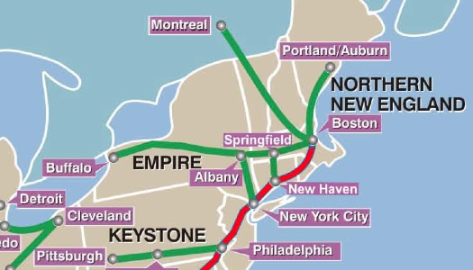
A system map from the future?
The federal stimulus bill has a lot of people talking about high-speed rail again because it includes $8 billion for such projects. The Secretary of Transportation says high-speed rail could be a "transformational issue" for the Obama Administration.
And one of the regions that supposedly will benefit is Upstate New York.
Great. We'd love to be able to hop a train in Rensselaer and be in NYC in less than two hours. But we're not ready to get our hopes us just yet.
Take that, Megabus!
 Stop. Before you book that Megabus trip to the Big Apple, you might want to check out the fares at Greyhound.com. It looks like Greyhound is trying to compete with the low, low Megabus fares.
Riding the Megabus
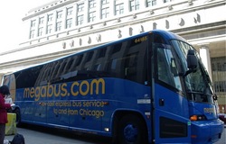 The Megabus started up service between Albany and NYC last month with the promise of (a few) one dollar fares. So how is it? Matthew Loiacono recently tried it out -- and it sounds like it went OK. From his account:
If you are looking for precise arrival times to NYC, this option may not be what you're looking for. For the trip down, the departure was exactly on time: 2:30PM, however the arrival to Penn Station was more like 5:45 instead of the expected 5:15PM. The traffic at that hour was insane, so I'd say it was in no fault to the company or the driver... more of typical NYC travel woes. The ride home was approximately 15 minutes late arriving to the Amtrak station, but one could chalk that up to the fairly inclement weather that dropped upon the northeast that weekend. It's not an exact science yet, so be prepared for a little wiggle-room on the arrivals.
If you're interested in taking the Mega, be sure to read Matthew's whole post -- he has a bunch of tips about taking it.
photo: Flickr user Andrew Ciscel
A note to CDTA
Helpful? Maybe not so much.
Dear CDTA,
We know how hard you're working to get us to ride the bus in the Capital Region. We appreciate that it's green and all -- and we love the song -- but CDTA, you gotta help us out here.
Albany's biggest parking ticket scofflaws
Let three of these slip and the city considers you a scofflaw.
So when we were looking up info on the Albany Parking Ticket Amnesty, we noticed a link at the bottom of the Parking Violations page: "CITY OF ALBANY TOP 20 SCOFFLAWS." And what do you know, there are some people who really need amnesty.
The list is after the jump.
The Megabus arrives

A Megabus in Chicago.
Check it out: a new-to-here bus company is starting up service between the Rensselaer train station and NYC.
And the lowest fares are $1. Yep, just $1
The guy on the big pink bike

We first saw The Big Pink Bike (our name for it) after Jess spotted it back in August. And since then, it seems like we've either been seeing it, or hearing about it, everywhere.
So who is this guy who rides The Big Pink Bike?
His name is Andrew Franciosa. He's a junior at UAlbany. And he was nice enough to answer a few questions we had -- most of all, why?
Bus fares and inflation

Is $1.50 to ride one of these a deal?
CDTA is currently in the process of examining a proposal to increase bus fares from $1 to $1.50. It would be the first increase since 1995. And CDTA's executive director Ray Melleady has said that when you take inflation into account, "one could argue that a $1.50 fare in 2009 is less expensive than $1 in 1995."
We could argue it -- or we could look it up. So, we did.
Money reportedly missing from DA's safe, Malta roundabout accidents up, mystery illness killing off local bats, libraries are hot
An audit by the Albany County comptroller has reportedly concluded that as much as $7,000 is missing from a safe in the Albany County DA's office. A 2005 audit of this same safe reported $25k missing -- but it later turned up in a safe deposit box. [TU]
A survey of residents in Albany's West Hill neighborhood, where Kathina Thomas was shot earlier this year, reports that more than half of the people there believe the area is unsafe and growing more violent. Seventy-five percent of the people surveyed had lived in the neighborhood less than three years. [TU]
The number of accidents along the stretch of five roundabouts in Malta is up, according to the state department of transportation. The number of serious injuries is down, though -- and rush hour travel times are a third of what they had been. A DOT official attributed the rise in accidents to people adjusting to the circles. [Daily Gazette]
Attendance for the ballet and orchestra at SPAC this past summer was down 9 percent, leaving the org $375,000 short of its budgeted goal for those performances. (Pop music attendance was up 27 percent.) Ticket sales for the ballet and orchestra don't even cover half the expense of hosting the two series. SPAC did end the season in the black, though, thanks to advertising and endowments. [TU] [Daily Gazette]
The Troy Bike Rescue
The Troy Bike Rescue's new space.
Sure, it might be getting a little chillier, but there's still plenty of bike-riding weather left. And if you don't have one of your own, the Troy Bike Rescue can help you out with that.
Fare increase for CDTA down the road?

Unofficial AOA transit correspondent, and official transit-riding superhero, This Quality Life sent along a report on today's CDTA board meeting. The short story: it really does look like fares will be going up 50 cents per ride next spring.
The slightly longer story from TQL:
Just watched today's CDTA board meeting -- the board acted to endorse the deficit reduction plan, they didn't officially vote on the budget (don't have to do that until December, I think) but this way they can move forward with informing the public about the plan to increase fares to $1.50/ ride effective 4/1/09, and again to $2/ ride in 2010, if the financial picture deems it necessary. They do not want to have to increase fares to $2/ ride in 2010, but want to leave the option open.
Apparently, 62% of transit organizations are looking at raising fares, but I wonder how many are raising them 50%??
I think such a steep increase is going to be a real hardship for most of the current bus riders, and I hope there will be plans to offset costs for those whose only reliable form of transportation is CDTA.
Update: Thursday's TU story has a few more details.
(Thanks, TQL!)
The Latham SPUI cannot be contained. The interchange project now has its own web site, complete with a news section, historical timeline and research documents. The url: exit6.org.
The most interesting part of the site is probably the "visualizations" section. It has a bunch of images depicting how the interchange will eventually look -- and it even has what looks like traffic simulation videos (we couldn't get those to load, though).
And you know what? We think we now know everything we'll ever need to know about SPUIs.
Earlier on AOA:
+ It's pronounced "spoo-ee"
+ Talkin' about SPUIs
image: NYSDOT
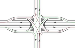
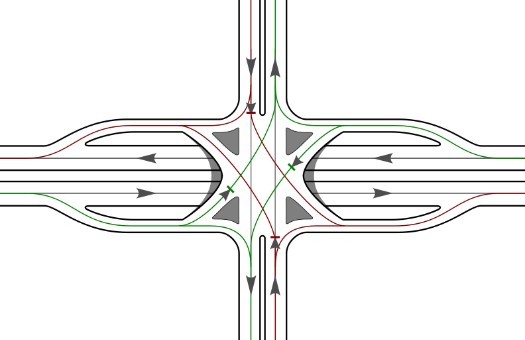
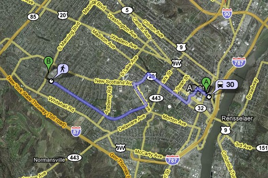
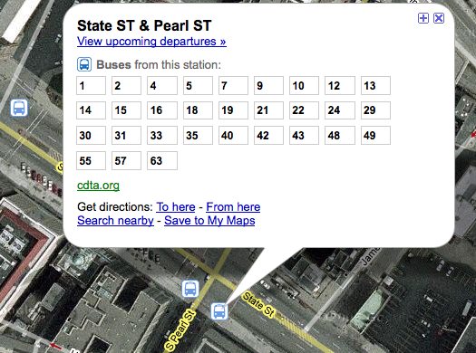
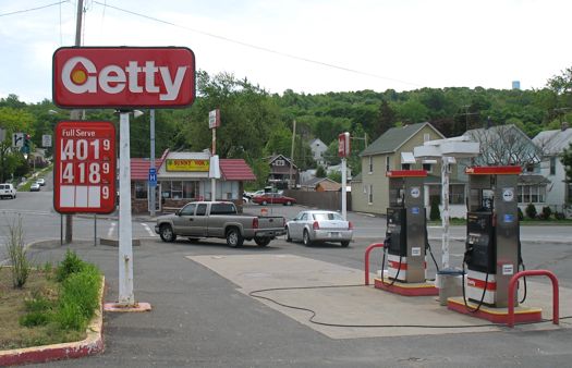
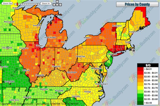
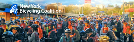
#/media/File:Inbound_train_at_Tappan_Street,_June_2014.JPG)
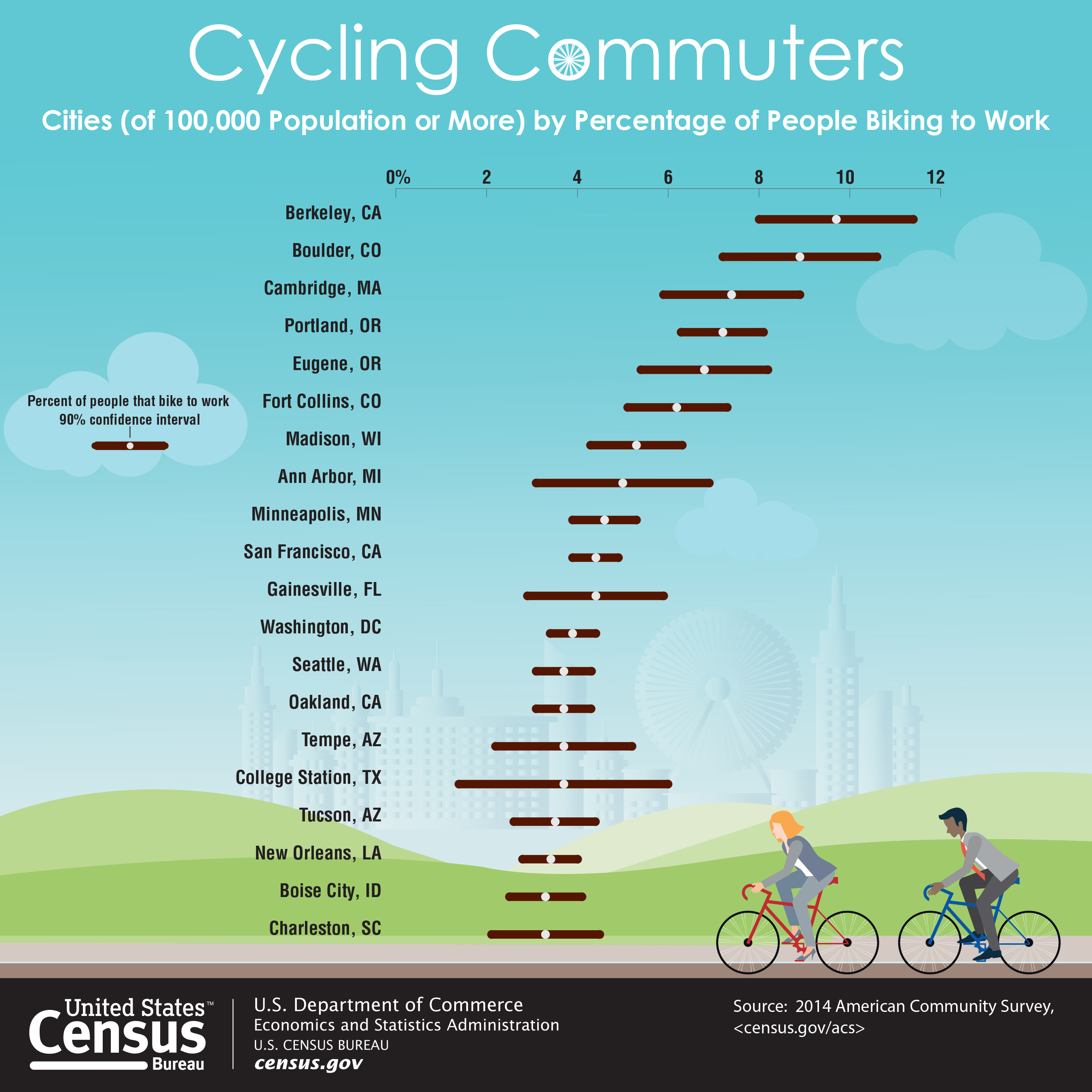
... said KGB about Drawing: What's something that brought you joy this year?